Download the Winston County Alabama map set as a ZIP containing four high-resolution A3 JPG files from the map-file box on this page. The maps cover county orientation, city locations, water features, and elevation, with Double Springs, Haleyville, Bankhead National Forest, Sipsey Fork, and Lewis Smith Lake providing the main geographic reference points.
Winston County sits in northwestern Alabama, but its internal geography is not organized around a single city. Double Springs is the county seat near the middle of the county, while Haleyville is the largest city and reaches across the Marion County line. Addison, Arley, Lynn, and Natural Bridge occupy different edges of the county, and the wide forested area between them is crossed by a dense network of streams rather than continuous development.
The supplied maps make those differences easier to see. The county reference map combines roads, places, water, and the boundary; the city view reduces the scene to six ranked communities; the water map emphasizes tributaries and the branching Smith Lake shoreline; and the elevation map shows the ridges and deeply incised valleys that shape travel across the county. The sections below use those visible features and the reference material packaged with the ZIP rather than adding places or statistics that are not supported by the source set.
Table of Contents
Winston County at a Glance
| State | Alabama |
|---|---|
| County | Winston County |
| County seat | Double Springs |
| Largest city | Haleyville |
| 2025 population estimate | 23,829 |
| 2020 land area | 613.00 square miles |
| Key roads shown | U.S. 278, Alabama 33, Alabama 195 |
| Key water features | Sipsey Fork, Lewis Smith Lake, Brushy Creek system |
| Download package | ZIP with four high-resolution A3 JPG maps |
The source material gives a July 2025 population estimate of 23,829, following a 2020 Census count of 23,540. It also lists 613.00 square miles of land and a 2020 density of 38.4 people per square mile. Those figures are consistent with what the maps show visually: relatively small population centers are separated by extensive forest, upland terrain, stream valleys, and reservoir shoreline.
Double Springs and Haleyville should be treated as different kinds of centers. Double Springs is the administrative center, with the county courthouse and government functions, while Haleyville is the larger city and a western border community. That distinction is useful because a map reader might otherwise assume that the largest city is also the county seat. In Winston County, the two roles are split between places in different parts of the county.
Six Communities Spread Across Different Parts of the County
The city-distribution map labels six communities: Haleyville, Double Springs, Lynn, Addison, Arley, and Natural Bridge. Haleyville is shown first in the ranking and lies along the northwestern edge. Double Springs is second and sits near the center. Lynn and Natural Bridge help anchor the western and southwestern side, Addison marks the northeast, and Arley provides a clear reference for the southeastern Smith Lake area.
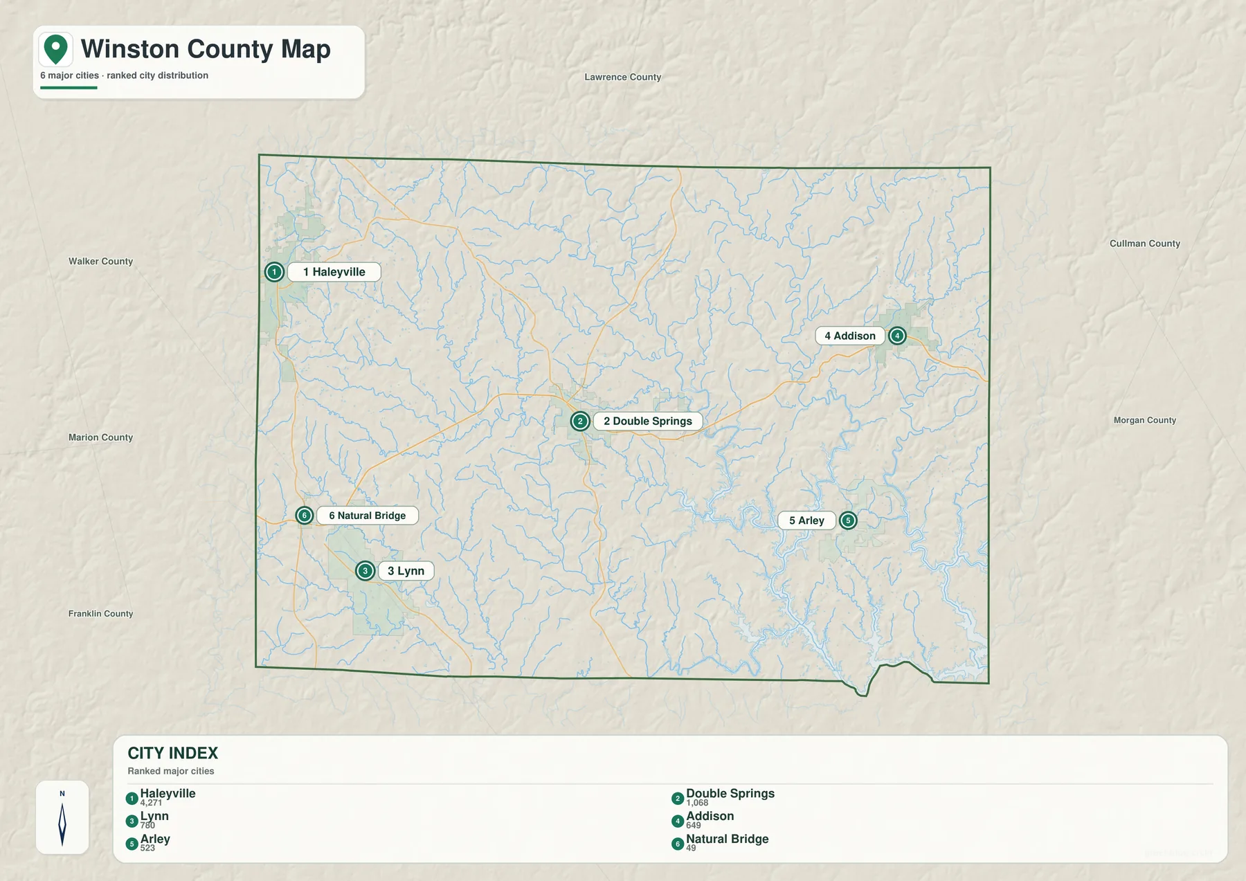
This distribution matters because Winston County does not have one continuous urban belt. The communities are separated by large rural and forested areas, and several are oriented toward county edges rather than toward Double Springs alone. Haleyville faces the Marion County side, Addison lies near the Cullman County direction, and Arley is tied geographically to the reservoir landscape in the southeast.
Haleyville also crosses the Winston–Marion county line. The existing source set notes that most of the city is associated with Winston County, but its border position explains why it functions differently from Double Springs. It is also widely known for the first 911 emergency telephone system in the United States, although for this map the more useful fact is its location: the city is a regional center placed directly on a county boundary.
Roads Between the Main Centers
U.S. 278 is the most obvious east–west route on the supplied county map. It crosses the middle of Winston County and passes through Double Springs, giving readers a simple line from the western side toward the Cullman County direction. Alabama 195 connects the Double Springs area with Haleyville to the northwest, while Alabama 33 runs through the central part of the county and provides a route toward the Bankhead forest landscape.
Additional numbered roads appear on the western side of the map, including 13, 74, 5, and 243. Their presence is a reminder that local movement is not reduced to one cross-county highway. Natural Bridge and Lynn are reached through a different part of the network from Addison or Arley, and the terrain becomes increasingly important when a straight map distance has to be converted into an actual driving route.
Boundary, Roads, Water, and Places on One Reference Map
The county reference map is the best starting point when the task is general orientation. It keeps the Winston County boundary visible while adding the principal communities, road numbers, and a light network of streams. Double Springs stands near the center, Haleyville is pushed against the northwest edge, Addison occupies the northeastern side, Arley sits in the southeast, and Natural Bridge and Lynn give the west and southwest recognizable anchors.
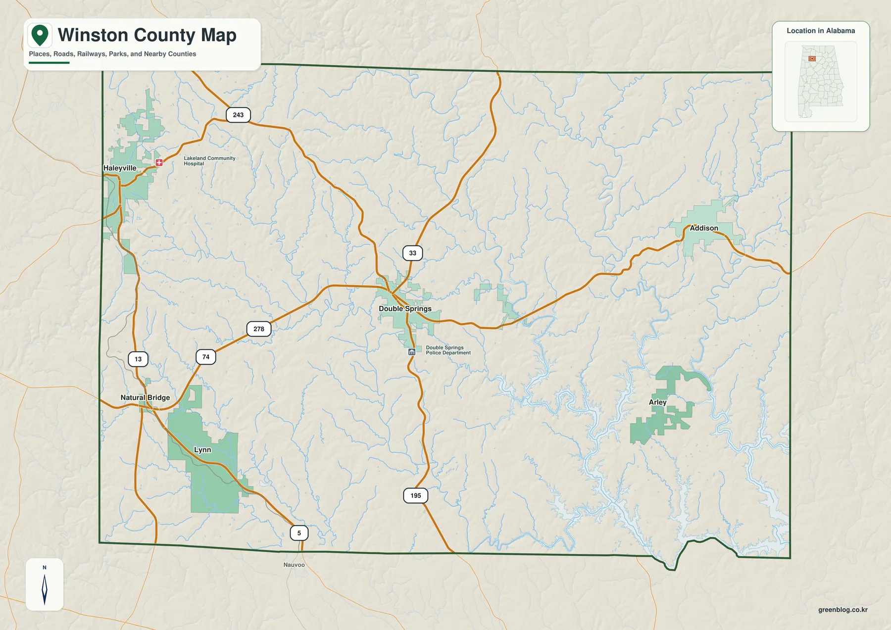
The contrast between the central road network and the stream-heavy east is especially noticeable. East and southeast of Double Springs, place labels become less frequent while drainage lines become denser. That visual difference matches the large Bankhead National Forest and Sipsey Fork landscape described in the supporting material. The absence of many city labels in that area is therefore meaningful; it reflects a broad forest-and-valley setting rather than a blank part of the map.
The source package identifies Franklin and Lawrence Counties along the northern side of Winston County, Cullman County to the east, Walker County to the south, and Marion County to the west. This county context is most useful for edge communities. Haleyville connects directly with the Marion side, Addison sits toward Cullman County, and the Smith Lake landscape extends beyond Winston into both Cullman and Walker Counties.
Sipsey Fork, Tributaries, and the Smith Lake Shoreline
The water map changes the emphasis completely. Instead of making roads and towns dominant, it shows how densely Winston County is divided by streams. Sipsey Fork is the major named feature in the southeastern half, and its channel opens into the branching Lewis Smith Lake system. The lake shoreline forms long narrow arms that reach inland, creating a much more intricate southeastern edge than the county boundary alone would suggest.
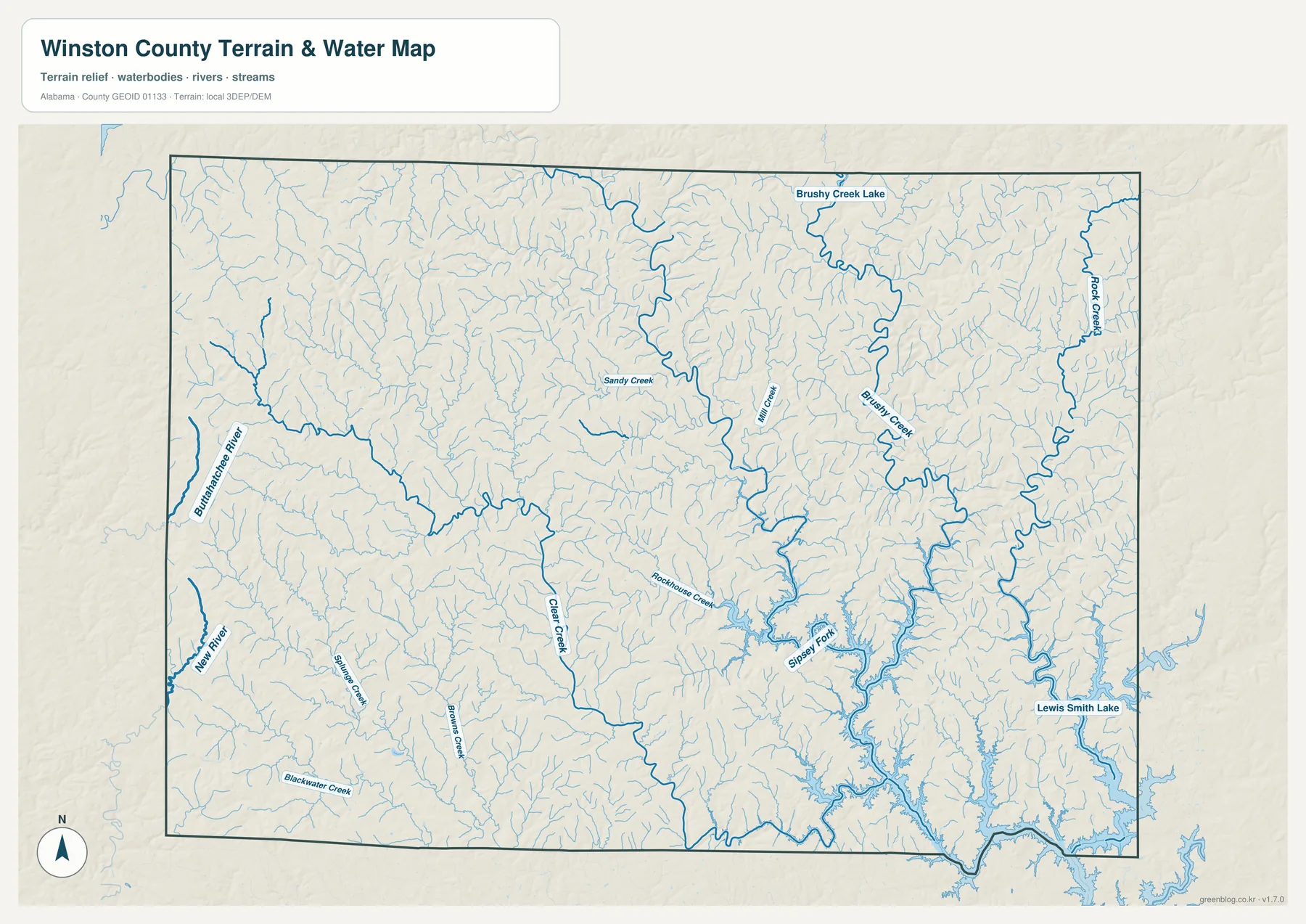
Several other names are visible on the supplied map, including Brushy Creek Lake, Brushy Creek, Rock Creek, Clear Creek, and Rockhouse Creek. A western river and additional smaller creeks show that drainage is spread across the county rather than funneled into one simple central channel. The fine tributaries are especially dense in the central and eastern terrain, where they cut through the plateau and feed larger streams.
The existing Winston County material identifies the Sipsey Fork as a defining waterway within the Bankhead National Forest area and connects it with Alabama’s National Wild and Scenic River system. Lewis Smith Lake, meanwhile, is a multi-county reservoir extending across Winston, Cullman, and Walker Counties. The Alabama Power reference in the ZIP lists Smith Reservoir at 21,200 acres, 642 miles of shoreline, and a maximum depth of 264 feet near the dam. Those numbers help explain why the lake occupies such a visually complex area on the map.
A Plateau Cut by Ridges and Stream Valleys
The elevation map explains much of the road and water pattern. Winston County is part of the Cumberland Plateau section of the Appalachian Highlands, and the supplied shaded-relief map shows a surface broken into many ridges and narrow valleys rather than a broad smooth plain. The map’s “Actual” readout gives an elevation range of roughly 149 to 310 meters, with a mean near 220 meters.
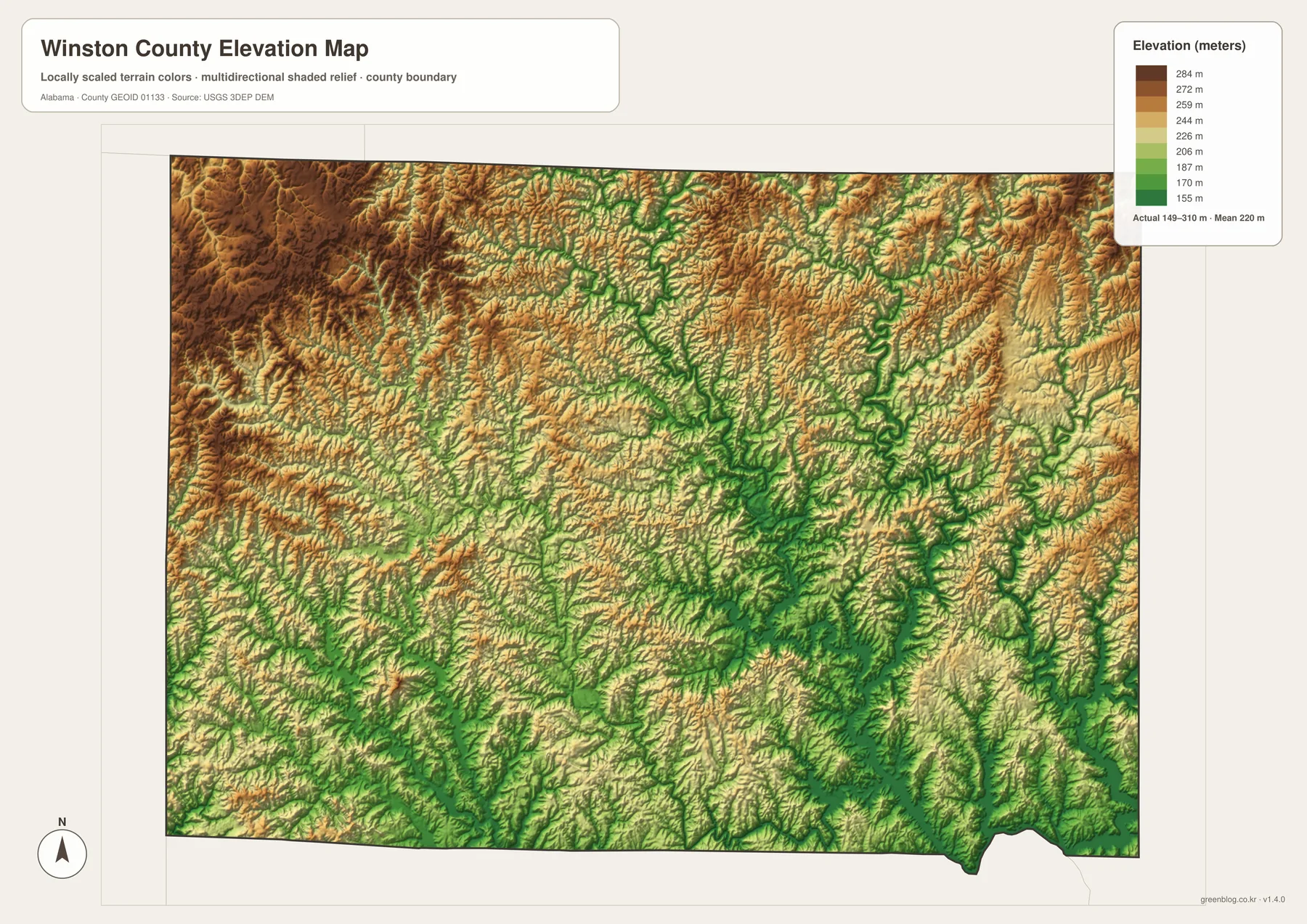
Higher ground is more prominent in the west and northwest, where brown and tan tones cover broader ridges. Lower green corridors branch through the central and eastern county along valleys, and the southeast becomes especially intricate around the Smith Lake drainage. When the elevation and water maps are compared, many of the low green lines correspond closely to the stream network.
This terrain also helps explain why roads do not always take the shortest apparent line between communities. A route may follow a ridge or a more manageable valley crossing instead of cutting directly across repeated drainage channels. For map users comparing Double Springs with Arley, Addison, or the western towns, the terrain view adds context that the city map intentionally leaves out.
Bankhead National Forest and the Large Forest Interior
William B. Bankhead National Forest occupies a major part of Winston County’s central and eastern landscape according to the supporting sources. The Bankhead Ranger District office is in Double Springs, while the forest itself extends across a broad area where streams and wooded valleys dominate the maps. This is one of the main reasons Winston County looks different from a county organized around continuous farmland or suburban development.
Within that forest setting, the Sipsey Wilderness protects part of the deeply dissected stream landscape. The existing county reference describes gorges, rock bluffs, and wooded valleys as characteristic features of the Cumberland Plateau here. Those features are not separately labeled everywhere on the maps, but their topographic expression is visible in the shaded elevation model and in the dense branching drainage network.
Putting the forest, water, and settlement layers together creates a clear four-part orientation: Double Springs provides an administrative center; Haleyville anchors the western border; the Bankhead–Sipsey landscape occupies much of the central and eastern interior; and Arley sits near the Smith Lake shoreline in the southeast. That pattern is more informative than simply listing towns because it explains why the towns are separated and why different sides of the county connect outward in different directions.
Choosing the Right Winston County Map for the Job
For a quick county overview, start with the reference map. It is the only view that combines the boundary, roads, selected communities, and water in a single frame. If the question is specifically where people and named communities are located, the city map is cleaner because it strips away much of the supporting detail and makes Haleyville, Double Springs, Lynn, Addison, Arley, and Natural Bridge easy to compare.
Use the water map when the Sipsey Fork, Smith Lake, or smaller tributaries are the main subject. Its dense blue network is useful for environmental context, watershed discussion, lake-area orientation, or simply understanding why the southeast has such an irregular shoreline. The elevation map is the better choice when the goal is to explain ridges, valleys, and why a route may curve around terrain rather than follow a direct line.
- County reference map: best for boundary, roads, communities, and overall orientation.
- City map: best for comparing the six labeled population centers without extra map clutter.
- Water map: best for Sipsey Fork, Lewis Smith Lake, Brushy Creek, and the tributary network.
- Elevation map: best for comparing uplands and incised valleys across the roughly 149–310 meter local range.
For a report or classroom handout, pairing two maps is often more useful than trying to make one map answer every question. The county reference map can establish where the towns and roads are, then the water or elevation view can explain the natural setting. The downloadable A3 JPG files preserve the larger layout for printing, while the WebP images on the page are convenient for quick viewing in a browser.
Frequently Asked Questions
Is Haleyville the county seat of Winston County?
No. Double Springs is the county seat and the administrative center used for county government. Haleyville is the larger city, but it lies on the Winston–Marion county line and serves a different geographic role on the western side of the county.
Is all of Lewis Smith Lake inside Winston County?
No. Lewis Smith Lake extends through Winston, Cullman, and Walker Counties. Within Winston County, the reservoir is most important to the southeastern Arley area and to the lower part of the Sipsey Fork system shown on the water map.
What is included in the downloadable map ZIP?
The ZIP contains four high-resolution A3 JPG files: the county reference map, the city map, the water map, and the elevation map. The WebP images embedded in the article are page previews, while the JPG files are the versions intended for larger documents and printing.
Map File Information
Winston County A3 map files
- Included Files: county map, city map, water map, and elevation map
Related Maps
- Abbeville, Headland, and Lake Eufaula on the Henry County Alabama Map
- Athens to Wheeler Reservoir on the Limestone County Alabama Map
- Autauga County Alabama Land Cover Map
Sources and Reference Material
The article uses the county-specific and official reference links supplied in the rewrite package. The county and encyclopedia pages provide local administrative and geographic context, while the Forest Service, Alabama Power, Census Bureau, and USGS resources support the forest, reservoir, population, water, and elevation information used alongside the maps.
- U.S. Census Bureau QuickFacts — Winston County, Alabama — population, land area, and basic county statistics
- Winston County, Alabama official website — county government and Double Springs administrative context
- U.S. Forest Service — National Forests in Alabama — Bankhead National Forest and the Sipsey area
- Alabama Power — Smith Dam — Lewis Smith Lake and Smith Reservoir information
- Encyclopedia of Alabama — Winston County — county geography, communities, roads, and regional background
- USGS National Hydrography — official hydrography reference
- USGS 3D Elevation Program — elevation data reference used for terrain mapping
Green Map creates custom-edited map images using open geographic data sources such as geoBoundaries, Natural Earth, OpenStreetMap, and government open data. These maps are edited visual materials, not raw data files, and are provided for education, documents, presentations, and graphic reference.