Hunt County sits northeast of the Dallas area, with Greenville near the middle of the county and several smaller cities spread toward Commerce, Caddo Mills, Quinlan, West Tawakoni, and Wolfe City. This page brings together a county road-and-place map, a focused city-distribution map, and a terrain-and-water map. The high-resolution JPG versions of all three maps are available in one downloadable ZIP, so visitors can move from a quick on-page preview to larger files for printing, comparison, or detailed reference.
The county is easiest to understand by following the contrast between its central road hub and its more dispersed northern, eastern, and southern communities. Greenville connects several important routes, Commerce forms a distinct northeastern center, and the towns near the northern edge of Lake Tawakoni occupy a different setting from both. The water map adds another layer: the South and Middle Sulphur rivers cross the north, while Caddo Creek and Sabine River tributaries organize drainage farther west and south. Those specific features make Hunt County more useful to describe as a set of connected local areas than as one uniform block.
Table of Contents
Greenville at the Center of the Road Network
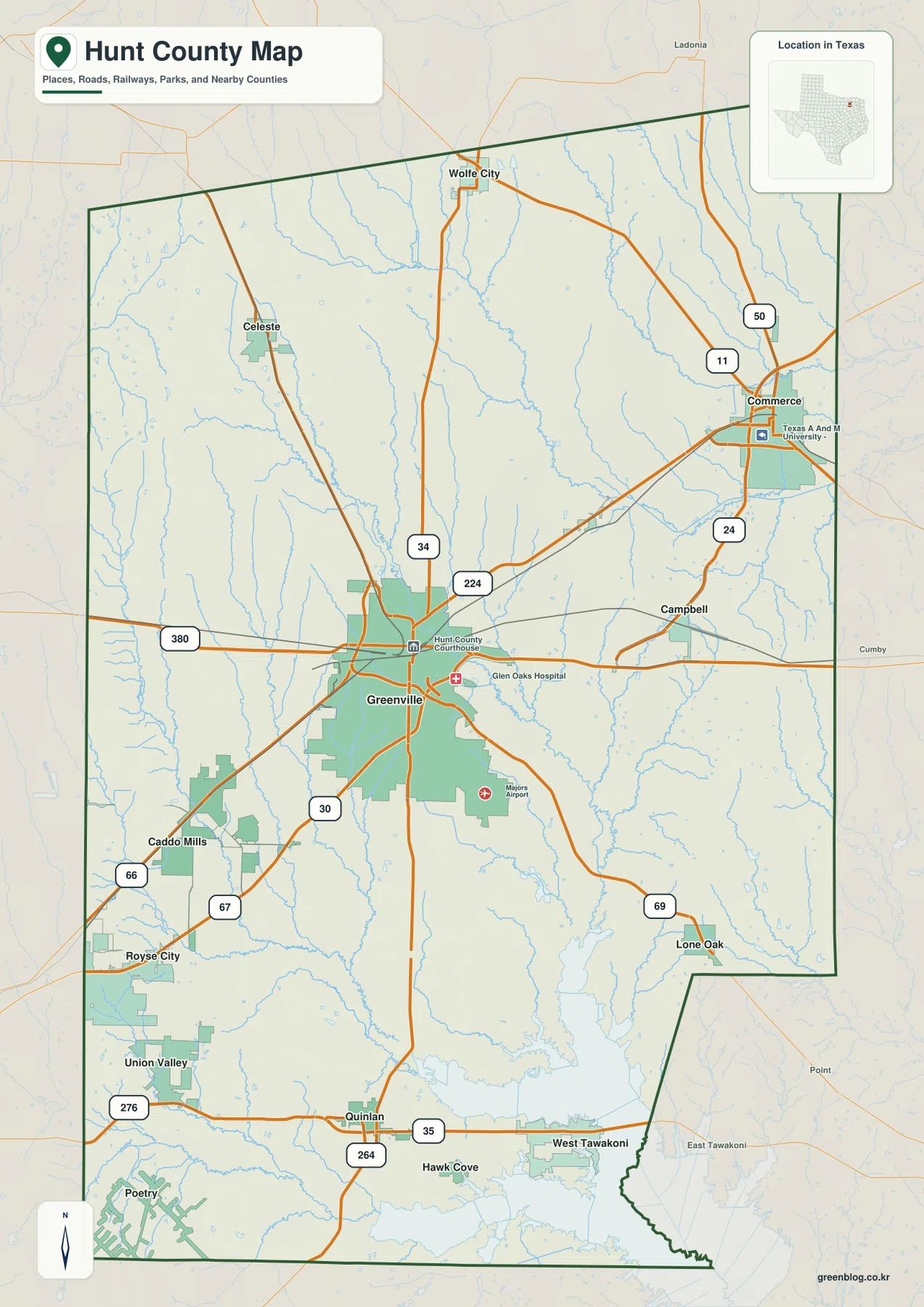
Greenville appears slightly south of the county’s midpoint and is the clearest starting point on the general map. Interstate 30 runs through the city from the Caddo Mills and Royse City side and continues eastward. U.S. 69 leaves Greenville toward Lone Oak, State Highway 34 heads north toward Wolfe City, and State Highway 224 connects Greenville with Commerce. Because these routes leave the city in several directions rather than following one dominant corridor, Greenville functions as a practical orientation point for the rest of the map.
Commerce stands out in the northeast, where the map also labels Texas A&M University-Commerce. Campbell and Lone Oak occupy the eastern and southeastern side of the county, while Quinlan, West Tawakoni, and Hawk Cove sit much closer to the large water body along the southern edge. Caddo Mills and Union Valley are positioned to the southwest, near the route toward Royse City and the Dallas region. The spacing among these places is as important as the labels themselves because it shows that local activity is distributed across several corridors.
I-30 and State Routes Connect Different Parts of the County
Interstate 30 is the most obvious east-west route on the map, especially on the western side of Hunt County. It links the Caddo Mills area with Greenville and continues toward communities beyond the county. From Greenville, State Highway 224 reaches Commerce, while State Highway 34 extends north toward Wolfe City. Around Commerce, State Highways 24, 11, and 50 create additional connections. South of Greenville, U.S. 69 provides a direct route toward Lone Oak and the southeastern side.
The county outline also places these roads in a wider regional setting. Collin and Rockwall counties lie to the west, Fannin County is to the north, and Delta and Hopkins counties are on the eastern side. The southeastern and southern edges approach Kaufman and Rains counties. Reading the roads together with the boundary makes it much easier to see which Hunt County communities face toward Dallas-area connections and which are more closely tied to the northeast Texas network around Commerce and the Sulphur River system.
Six Highlighted Cities Show a Widely Spaced Settlement Pattern
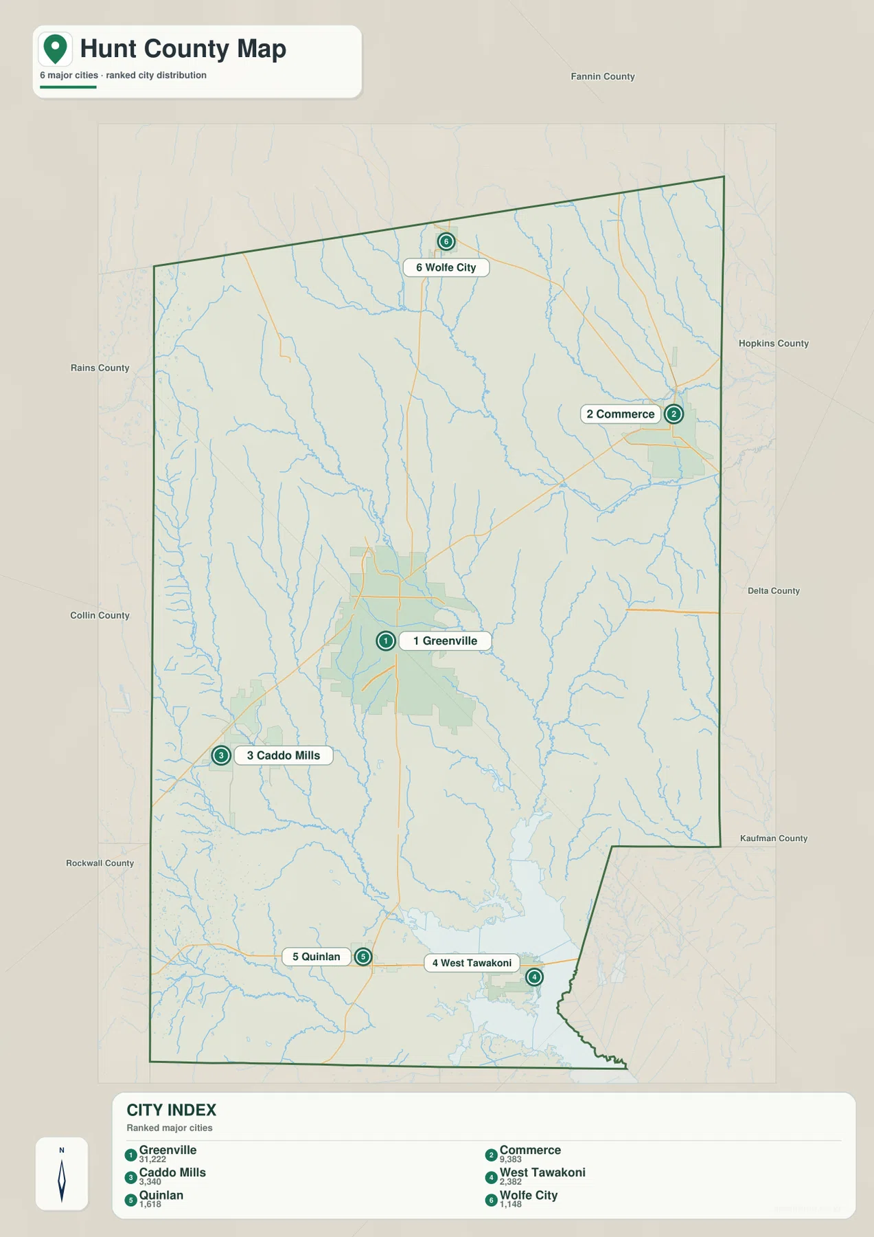
The city map highlights six places rather than trying to give every settlement equal visual weight: Greenville, Commerce, Caddo Mills, West Tawakoni, Quinlan, and Wolfe City. Its City Index displays values of 31,222 for Greenville, 9,383 for Commerce, 3,340 for Caddo Mills, 2,382 for West Tawakoni, 1,618 for Quinlan, and 1,148 for Wolfe City. The image does not state a reference year, so these numbers are best treated as the index values printed on the supplied map rather than as a claim about the latest population estimate.
The positions tell an even clearer story. Greenville is central, Commerce is near the northeastern edge, and Wolfe City is well to the north. Caddo Mills marks the southwest, while Quinlan and West Tawakoni form a southern pair close to the large reservoir. This pattern gives Hunt County several recognizable directions: a central administrative and transport center, a northeastern university city, a southwest approach toward the Dallas region, and a southern lake-oriented area.
Commerce and the Lake-Side South Occupy Different Geographic Settings
Commerce is visually distinct from Greenville because it sits farther northeast and is accompanied by the Texas A&M University-Commerce label. State Highway 224 provides a direct mapped connection between the two cities, while several smaller streams cross the land around that corridor. Wolfe City adds another northern reference point, so the upper half of the county is not simply an extension of Greenville’s built-up area; it contains separated communities connected by roads across open land and drainage lines.
The southern pattern is different. Quinlan and West Tawakoni are close to the northern reach of Lake Tawakoni, with Hawk Cove nearby and several smaller settlements extending westward. The general map shows a broad water area along the southern edge, and the city map places West Tawakoni almost directly against that shoreline environment. Anyone comparing Greenville with the southern communities should therefore keep the reservoir in view because it is a much stronger geographic reference there than it is in the center of the county.
South and Middle Sulphur Rivers Define the Northern Water Network
The terrain-and-water map makes the northern drainage network much easier to see. South Sulphur River crosses the upper part of the county, while Middle Sulphur River runs through the northeast. Wolfe City Reservoir No. 2 is labeled near the north, and Round House Pond appears farther east. Numerous smaller tributaries feed these larger lines, giving the northern third of Hunt County a dense pattern of branching streams that is much less obvious on the road map.
Farther south and west, the named waterways change. Cuthbert Fork Sabine River forms a long, prominent line through the middle of the county. Hickory Creek lies to its west, and West Caddo Creek and East Caddo Creek descend through the western side. Elm Creek and Brush Creek are also labeled, while South Fork Sabine River appears near the southwestern edge. The supplied map therefore shows Hunt County crossing more than one recognizable drainage system rather than sending all local water toward a single river.
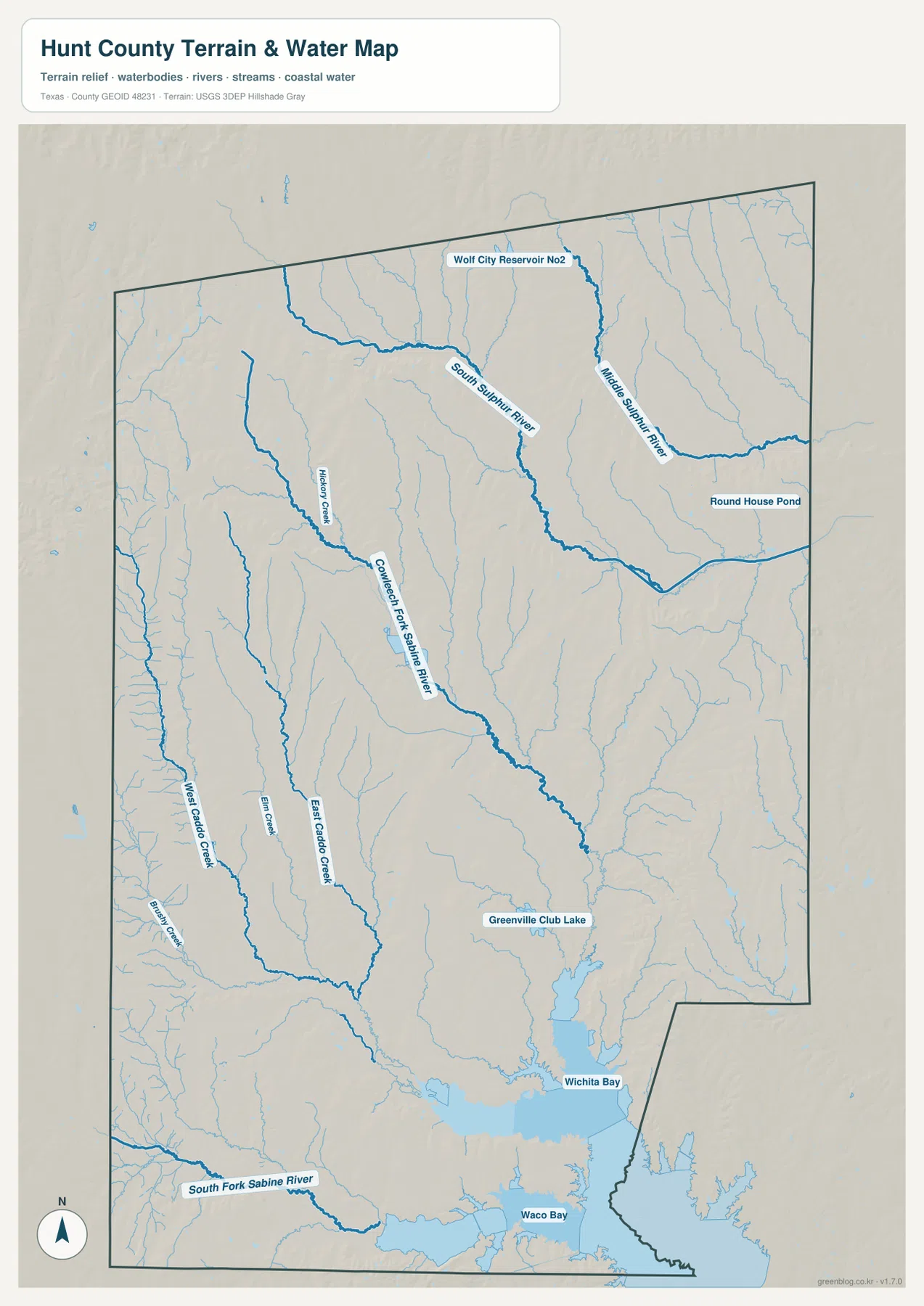
Wichita Bay and Waco Bay Mark the Lake Tawakoni Edge
At the southern end of the water map, the large reservoir is accompanied by labels for Wichita Bay and Waco Bay. Greenville Club Lake is marked just to the north. When those features are compared with the city map, the location of West Tawakoni and nearby communities makes more sense: they occupy a lake-side setting that differs sharply from the road-focused center around Greenville and the river-crossed northeast around Commerce.
This map should be read as a geographic reference for the position of rivers, creeks, ponds, reservoirs, and shorelines. It is not a flood-risk map, legal property map, depth chart, or navigation product. A visitor who needs flood zones, surveyed boundaries, boating depth, or engineering measurements should use the appropriate official source. Here, the useful task is simpler: compare the named waterways with the county’s cities and road corridors.
Choose the Map That Matches the Question
The general county map is the best choice when roads, places, and neighboring counties need to be seen together. It is especially useful for locating Greenville relative to Commerce, Caddo Mills, Lone Oak, Quinlan, and Wolfe City. The city map is cleaner when the main goal is to compare the six highlighted communities without the distraction of every smaller label. For rivers and reservoir features, the terrain-and-water map is the stronger option because it names the Sulphur River branches, Sabine tributaries, Caddo Creek system, and lake-side bays.
These are three views of the same county, not three interchangeable designs. A printed handout about regional roads will usually benefit from the general map, while a community comparison may work better with the city map. A discussion of the Lake Tawakoni shoreline or the difference between northern and southern drainage needs the water map. Selecting one based on the subject keeps labels readable and avoids crowding a page with information that is not needed.
Frequently Asked Questions
How can I quickly distinguish Greenville from Commerce on the map?
Greenville is the larger central road hub where I-30, U.S. 69, State Highway 34, and State Highway 224 are easy to identify. Commerce is northeast of Greenville and is marked near Texas A&M University-Commerce. Following State Highway 224 between them is a simple way to establish their relative positions.
Which map is best for the Lake Tawakoni side of Hunt County?
The city map is useful for locating Quinlan and West Tawakoni, but the terrain-and-water map is better when the shoreline, Wichita Bay, Waco Bay, and nearby streams matter. The water map is a location reference only and should not be used as a flood or navigation chart.
What is included in the downloadable Hunt County map file?
The ZIP contains three original high-resolution JPG files corresponding to the county road-and-place map, the city-distribution map, and the terrain-and-water map. They are larger source files than the WebP previews used in the article and are more convenient for saving, printing, or zooming in.
Map File Information
Download the original high-resolution JPG files for all three Hunt County maps shown on this page in one ZIP archive.
- File Type: ZIP containing 3 JPG files
Related Maps
- Rains County Texas map
- Rockwall County Texas map
- Van Zandt County Texas map
- Red River County Texas map
- Wood County Texas map
Map Data and Reference Sources
For official boundary, road, and place-file context, see the U.S. Census Bureau TIGER/Line Shapefiles. Official hydrography information is available through USGS National Hydrography, and the USGS The National Map Viewer provides a convenient way to compare multiple geographic layers.
Green Map creates custom-edited map images using open geographic data sources such as geoBoundaries, Natural Earth, OpenStreetMap, and government open data.
These maps are edited visual materials, not raw data files, and are provided for education, documents, presentations, and graphic reference.