You can download high-resolution Hutchinson County map files from this page while comparing four complementary views of the county: roads and settlements, major-city connections, waterways and terrain, and elevation. The maps place Borger, Stinnett, Fritch, and Sanford in a landscape that is much less flat than a quick glance at the Texas Panhandle might suggest. The Canadian River cuts a broad low corridor across the southern half of the county, tributaries descend into it from both sides, and Lake Meredith lies close to the southwestern side of the mapped area.
Stinnett is the county seat, but the city-connections map uses Borger as its hub. That difference is useful rather than confusing: one map emphasizes civic geography, while another shows the largest local population center and its relationship to nearby communities. State Highway 136 links Borger and Stinnett, State Highway 152 crosses Stinnett, and the river system occupies the lower ground between upland surfaces. Reading those features together gives Hutchinson County a clear north-south and upland-canyon structure before any smaller labels are considered.
Table of Contents
Borger on the south, Stinnett on the upland north
The county map gives Borger and Stinnett two very different visual settings. Borger sits near the southern edge of the mapped county where several roads and developed-area symbols are concentrated. Stinnett appears farther north at the meeting of SH 136 and SH 152. Fritch and Lake Meredith Estates are off to the southwest, while Sanford lies west of the main Borger-Stinnett line. The pattern is therefore not a single cluster with suburbs spreading evenly in every direction. Instead, the named communities occupy separate parts of the county and are connected by a small number of obvious road corridors.
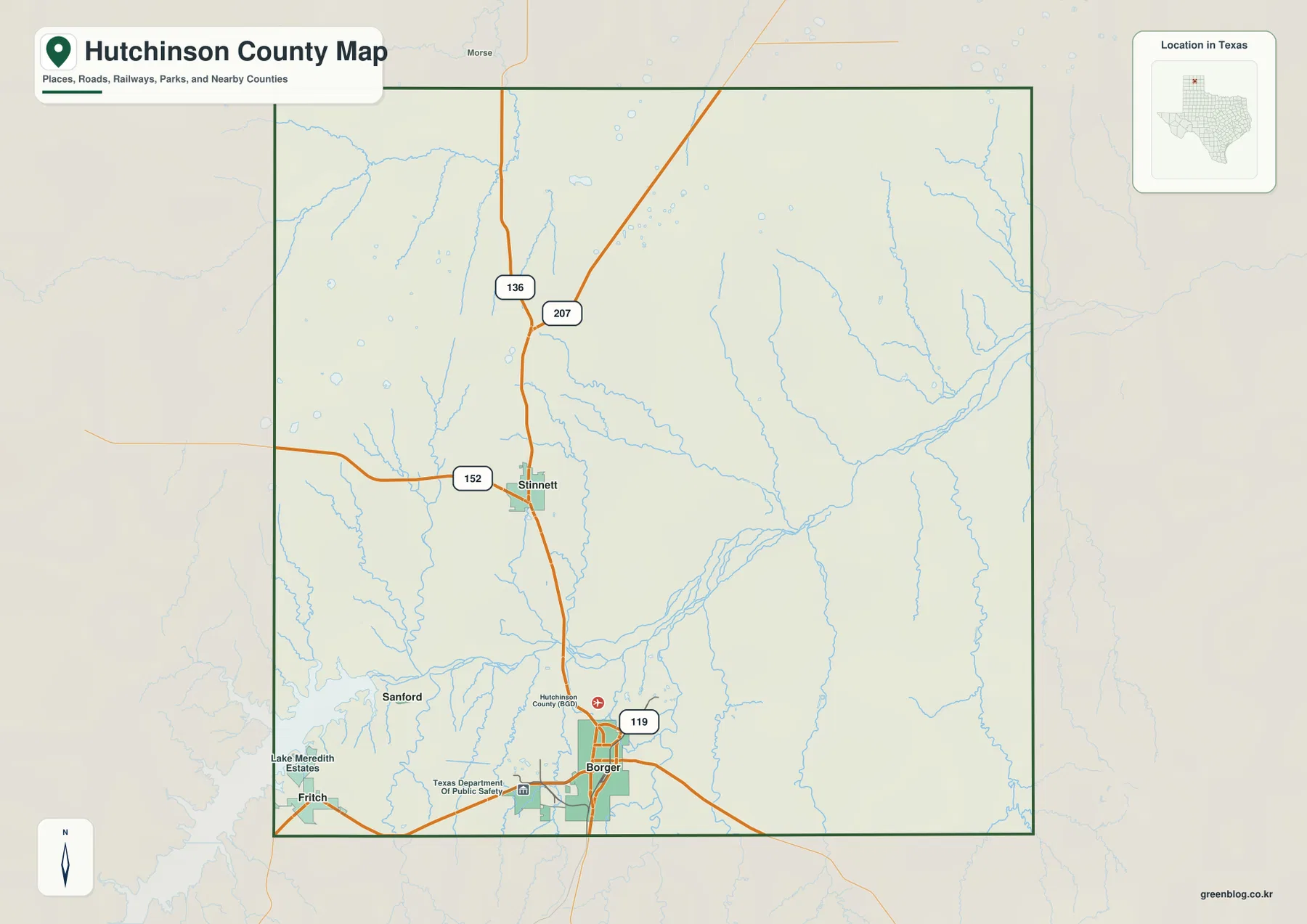
SH 136 provides the clearest internal north-south line. It leaves Borger, passes toward Stinnett, and continues north, while SH 207 is labeled farther north and SH 152 extends west and east from the Stinnett area. Around Borger, SH 119 is also marked. Those roads help explain why the two main centers are easy to locate on the county map even though the Canadian River valley and its tributaries create a much more irregular natural surface around them. For a visitor trying to orient quickly, Borger is the strongest southern landmark and Stinnett is the strongest northern civic landmark.
Four communities within a short radius of Borger
The city-connections map simplifies the county to four highlighted communities and uses Borger as the hub. Its distance labels are straight-line distances, not driving mileage. Stinnett and Fritch are each shown at about 12 miles from Borger, while Sanford is about 8 miles away. Those similar numbers do not imply identical travel routes. Stinnett is north of Borger, Fritch lies to the southwest, and Sanford sits west of the main north-south corridor, so each trip leaves the hub in a different direction and meets a different part of the local road and drainage network.
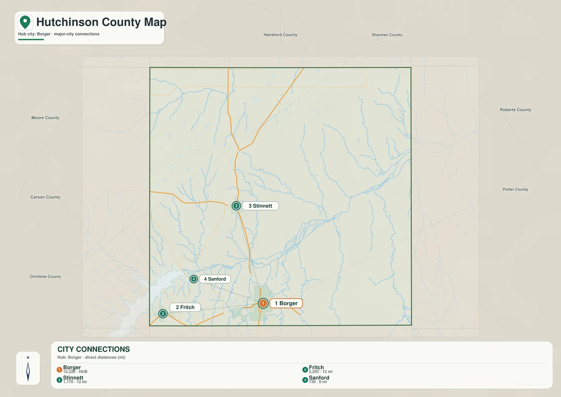
The index on the map lists Borger at 12,226 people, Fritch at 2,293, Stinnett at 1,170, and Sanford at 130. These figures are most useful as a map-reading aid because they explain why Borger receives the hub treatment even though Stinnett is the county seat. The distinction also prevents a common mistake when reading county maps: the administrative center does not have to be the largest population center. On this map pair, Stinnett identifies county government and a major road junction, while Borger anchors the larger urban concentration in the south.
The Canadian River collects a wide fan of Panhandle tributaries
The terrain-and-water map changes the character of the county immediately. The Canadian River is the dominant blue line, entering from the Lake Meredith side and running eastward through the lower half of the county. Cottonwood Creek descends from the north-central area to the river. South Palo Duro Creek is labeled across the far north. South and east of the Canadian River, Spring Creek, Bear Creek, Dixon Creek, and White Deer Creek form additional branches. Instead of a featureless sheet of plains, the map shows a network of channels that repeatedly cuts into the surrounding uplands.
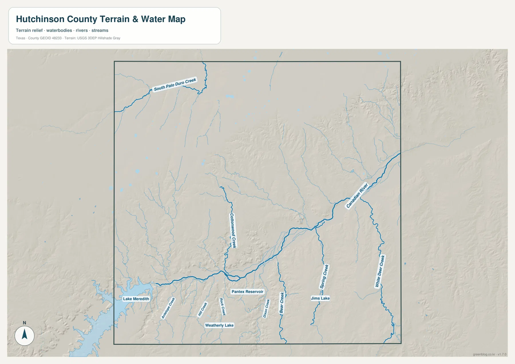
Lake Meredith is the largest water body visible near the southwestern side of the map. Smaller labeled waters include Weatherly Lake, Pantex Reservoir, and Jims Lake. Their presence helps separate the southwestern reservoir country from the more dissected creek network farther east. This is a reference map for the location of water and terrain; it is not a flood-risk map, legal water-boundary product, or navigation chart. Its strongest use is to show why a road or community that appears close in straight-line distance may still sit on the opposite side of a river valley or branching drainage.
About 240 meters of relief inside the county boundary
The elevation map reports an actual range of roughly 791 to 1,031 meters, with a mean near 935 meters. The lowest colors form a long green corridor that closely follows the Canadian River. Narrow green fingers extend away from that corridor where tributaries have cut into the surrounding land. Higher surfaces appear in tan, orange, and brown, particularly across broad upland areas away from the main river. A vertical difference of about 240 meters is substantial enough to make the river breaks visually dominant even within this part of the Texas Panhandle.
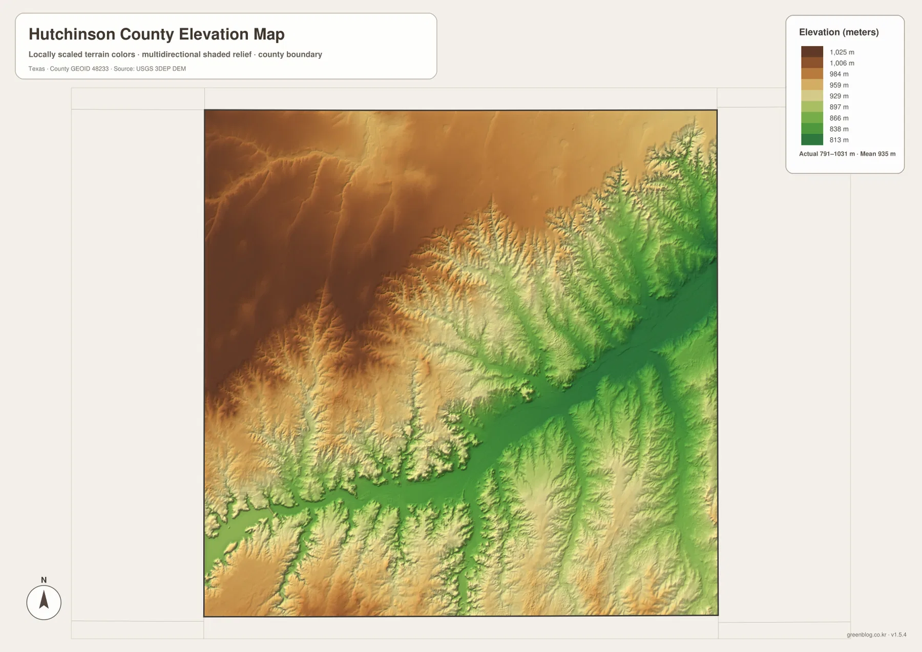
Comparing the elevation map with the water map is especially revealing. Many of the named creeks occupy the same narrow lower-color valleys, and the Canadian River follows the broadest low band. The relief shading also shows steep, closely spaced valley walls where tributaries join the main river. The surface is generalized from elevation data and should not be treated as survey-grade or engineering-grade measurement, but it works well for county-scale interpretation, classroom comparison, trip planning, and understanding why the river corridor looks so different from the open upland surface.
Choosing the clearest view for roads, water, or terrain
For road orientation, the county map is the most direct choice because it keeps Borger, Stinnett, Fritch, Sanford, SH 136, SH 152, SH 119, and the county boundary in one frame. For a quick comparison of settlement positions, the city-connections map removes much of the extra detail and adds straight-line mileage from Borger. The terrain-and-water map becomes more useful when the Canadian River, Lake Meredith, Cottonwood Creek, Spring Creek, or the smaller tributaries are the subject. The elevation map is the best match for explaining the canyon-like breaks and the contrast between low river valleys and higher plains.
A practical way to use the set is to trace one place across all four views. Start with Borger on the county map, note its relationship to Stinnett and Fritch on the city map, move to the Canadian River just north of the southern urban area on the water map, and then locate the same low corridor on the elevation map. Repeating that process with Fritch and the Lake Meredith side makes the connection between settlement, reservoir water, tributaries, and relief much easier to see than any one map can show by itself.
The WebP images above are sized for efficient viewing on the page. The downloadable archive below contains the matching high-resolution JPG originals for printing, enlargement, offline study, or use in a personal reference collection.
Frequently Asked Questions
Why does the city map use Borger as the hub if Stinnett is the county seat?
The two labels describe different things. Stinnett is the county seat, while the city-connections map highlights Borger as the hub and lists it as the largest of the four indexed communities. Use Stinnett when locating county government and the SH 136/SH 152 junction; use Borger when comparing the larger southern population center with Fritch, Sanford, and Stinnett.
Are the 8-mile and 12-mile city distances driving distances?
No. The city-connections legend states that the distances from Borger are direct, straight-line distances. The road mileage can be longer because Stinnett, Fritch, and Sanford lie in different directions and the Canadian River drainage introduces terrain that roads must cross or work around.
Where is the strongest elevation contrast visible?
The strongest contrast follows the Canadian River corridor. The map reports an actual county range of about 791 to 1,031 meters, and the low green band along the river is bordered by higher tan and brown uplands. Tributary valleys produce additional narrow low strips that connect to the main river corridor.
Sources and reference data
Official reference sources include the U.S. Census Bureau TIGER/Line Shapefiles for boundaries and mapped features, USGS National Hydrography for rivers and streams, and the USGS 3D Elevation Program for elevation data. The USGS The National Map Viewer can be used to compare multiple official geographic layers in one interface.
Map File Information
Download the high-resolution JPG originals for the Hutchinson County road-and-settlement, city-connections, terrain-and-water, and elevation maps in one ZIP archive.
- File Type: ZIP containing JPG images
Related Maps
- Ochiltree County Texas map
- Roberts County Texas map
- Sherman County Texas map
- Armstrong County Texas map
- Potter County Texas map
Green Map creates custom-edited map images using open geographic data sources such as geoBoundaries, Natural Earth, OpenStreetMap, and government open data.
These maps are edited visual materials, not raw data files, and are provided for education, documents, presentations, and graphic reference.