Taylor County Florida Map files on this page can be previewed in the article and downloaded as high-resolution A3 JPG images in one ZIP archive. For orientation, start by separating inland Perry from the long, low Big Bend coast: Perry is the county seat and clearest road hub, where US 19, US 98, US 27, and US 221 provide the main regional directions. The coast works differently, with Steinhatchee, Keaton Beach, Dekle Beach, river mouths, marshes, and boat-access points spread along separate branch roads rather than one continuous beachfront highway.
The county reference map is best for roads and boundaries, the city map isolates Perry as the incorporated city shown in the ranking, and the terrain-and-water map highlights rivers, creeks, lakes, ponds, and the Gulf shoreline. The downloadable JPG originals are larger than the WebP previews and are suited to printing, lessons, presentations, and offline reference.
Table of Contents
Perry is the easiest place to begin reading the county
Perry sits in the north-central interior and gives the county map its strongest road reference. US 19 and US 98 share the main corridor south of the city, US 27 leaves toward the northeast, and US 221 runs north toward the Madison County direction. State and local routes around Perry add shorter connections, but those four federal highways explain most of the county’s regional movement at a glance.
South of Perry, the US 19/98 corridor leads toward Tennille and the southeastern part of Taylor County. From that general area, SR 51 continues toward Steinhatchee at the Steinhatchee River. Keaton Beach and Dekle Beach are farther west and use separate coastal access roads. That road pattern is important because places that appear close when measured along the shoreline can require a much longer inland drive around marshes and tidal channels.
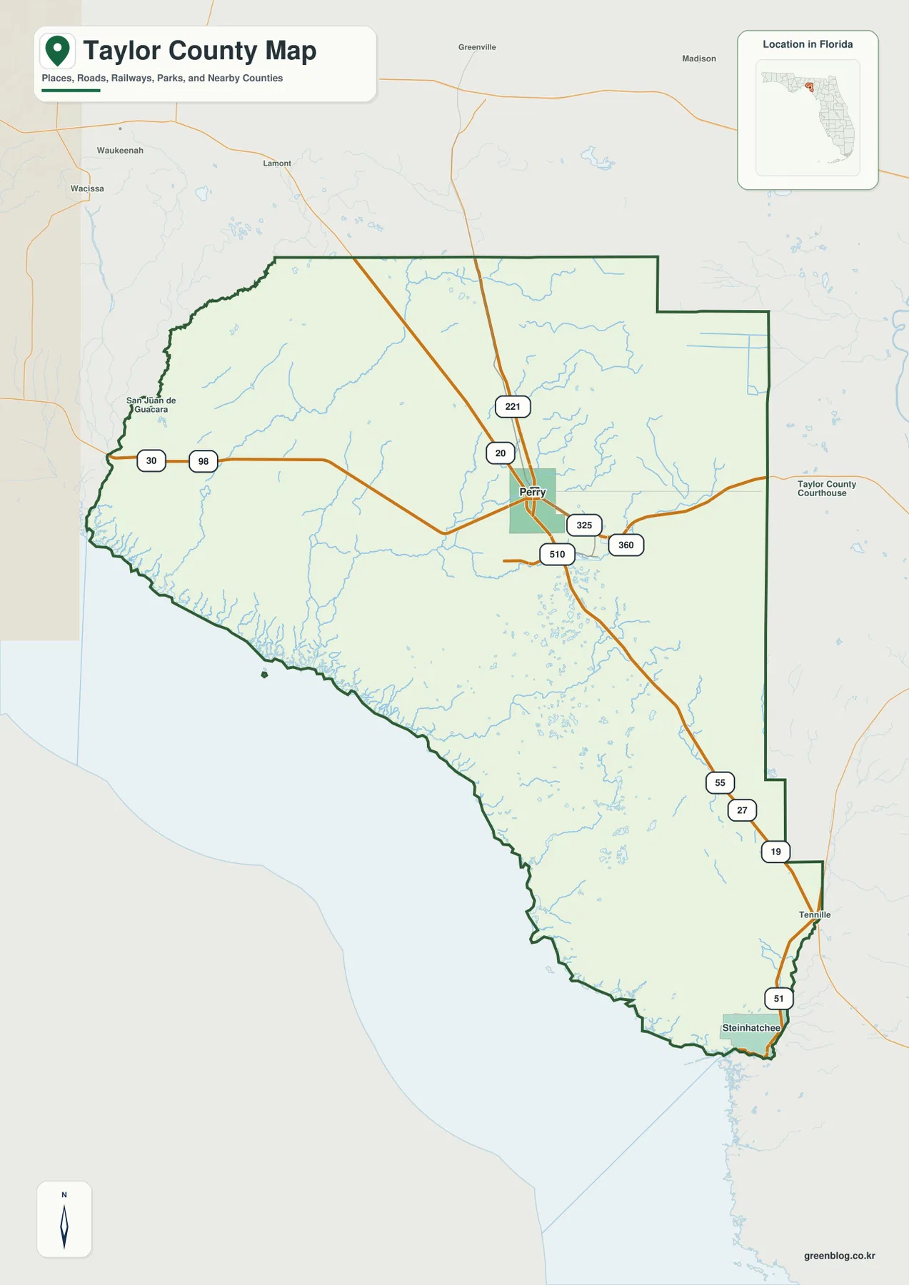
The county outline reinforces that inland-to-coast contrast. Madison County lies to the north, Jefferson County to the northwest, Lafayette County to the east, and Dixie County to the southeast. Along the southwest side, the boundary opens to the Gulf on Florida’s Big Bend. Parts of the eastern boundary look relatively straight, while the western and southern edge becomes irregular where rivers, marsh, and the coast shape the county’s outline.
Why the city map shows only Perry
The city-ranking map is unusually simple because Perry is the only incorporated city shown for Taylor County. Steinhatchee, Keaton Beach, Dekle Beach, Shady Grove, Salem, and other named communities remain important geographic references, but they do not appear in the same incorporated-city category. Comparing the city map with the full county map is therefore useful for separating legal municipal status from the much broader pattern of settlement.
The simplicity also makes the size of the county more obvious. Perry occupies one compact spot while broad areas of forest, wetland, river country, and coast surround it. The city index prints Perry as the first-ranked city, but the more useful lesson for a map reader is that a single incorporated municipality serves as the administrative center of a county with many dispersed communities and coastal destinations.
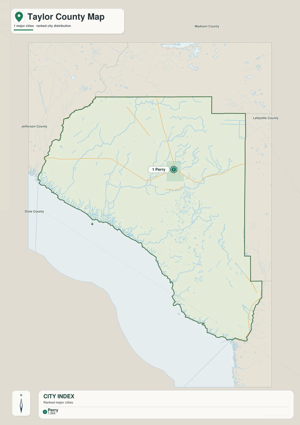
The difference between Perry and the coastal communities also shows up in how visitors use the map. Perry functions as the county seat and the principal inland service center. Steinhatchee has a strong river-and-coast identity in the southeast, while Keaton Beach and Dekle Beach are separate shoreline communities reached by other roads. A useful Taylor County map therefore needs more than one city label; it needs roads and water features that explain how those places are actually connected.
Econfina and Fenholloway rivers define the western water map
The terrain-and-water map shifts attention away from highways. The Econfina River is labeled in the northwestern coastal section, while the Fenholloway River reaches the Gulf farther south. Rocky Creek and Spring Creek appear in the interior, and Andrews Lake is marked near the north. South and southeast of Perry, smaller named waters include Bird Pond, Bear Harbor Lake, George Ann Lake, Big Lilly Lake, Big Trail Pond, Adams Pond, and Horse Pond.
Those features help explain why Taylor County’s interior and coast are not visually empty even where towns are sparse. Many small creeks, ponds, wet areas, and river corridors cross the broad forested landscape. Near the Gulf, the waterways open into a deeply indented Big Bend shoreline rather than a simple straight beach. Existing county and Florida coastal material describes this coast as dominated by shallow water, salt marsh, seagrass, tidal creeks, and river mouths, with very little broad sandy beach.
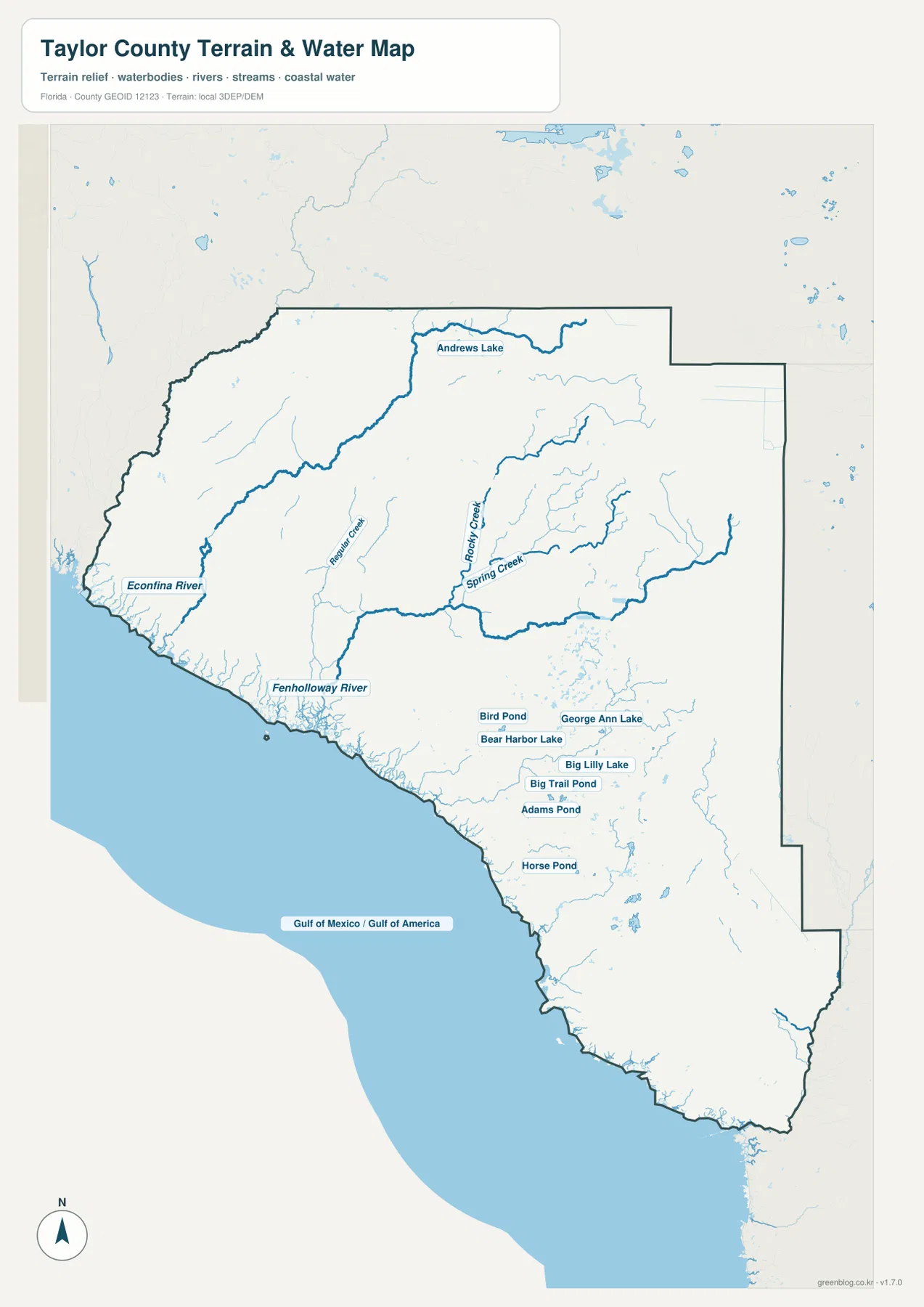
The shaded background gives broad terrain context, but it is not a survey-grade or engineering elevation model. Likewise, the blue water features are location references rather than a flood map, nautical chart, parcel map, or live river-stage product. Before boating, fishing, or visiting low coastal roads, use this map to understand where a destination sits and then check current tide, weather, ramp, and road information from the responsible agency.
Taylor County’s coast is reached by separate branch roads
The Big Bend shoreline is not connected by one continuous coastal highway. Steinhatchee lies at the southeastern edge near the Steinhatchee River and is reached from the inland highway corridor through SR 51. Keaton Beach and Dekle Beach sit farther west and use a different road network from the Perry side. Marsh, river mouths, and tidal channels divide the shoreline between them.
That separation is one of the most practical things to learn from the county map. Keaton Beach and Steinhatchee may look fairly close in a straight line, yet a driver cannot simply follow the coast between them. The road route moves inland around wetland and waterways. The same branch-road pattern appears at other coastal access points, where a county road or local road leaves the main US highway and ends near a river, ramp, or small coastal settlement.
Econfina River State Park in the northwestern coastal section is a good example of that geography. Its river-and-marsh setting is reached from inland roads rather than a continuous beach strip. Taylor County also lists boating access at several dispersed coastal locations, which is another reason a map should be read by road approach and river mouth rather than by shoreline distance alone.
Which Taylor County map should you use?
Choose the county reference map when you need Perry, neighboring counties, highway directions, or the overall relationship between the inland center and the coast. The city map is useful when you specifically want the incorporated-city layer without extra road and water labels. Use the terrain-and-water map for the Econfina River, Fenholloway River, Rocky Creek, Spring Creek, named lakes and ponds, and the broad shape of the Gulf shoreline.
For a classroom exercise, you can begin by locating Perry and the county boundaries, then trace the highways toward different coastal destinations, and finally switch to the water map to see why those road branches are separated. For trip planning, the same sequence gives good geographic background, but it does not replace live navigation or current closure and weather information.
Frequently Asked Questions
Is Perry the only incorporated city shown in Taylor County?
Yes. The supplied city map shows Perry as the incorporated city. Steinhatchee, Keaton Beach, Dekle Beach, and other named places are important communities, but they are not shown in the same incorporated-city category.
What is the clearest road pattern from Perry toward Steinhatchee?
The easiest pattern to follow is the US 19/98 corridor southeast from Perry toward Tennille, then SR 51 toward Steinhatchee. Current traffic or road-condition information should still be checked separately before travel.
Are Keaton Beach and Steinhatchee connected by one coastal road?
No. They use separate access-road systems, and wetlands and waterways lie between them. Driving generally requires an inland route rather than following the shoreline directly.
Does an Interstate highway cross Taylor County?
No. The main regional network shown in the county material is built around US 19, US 27, US 98, and US 221. Interstate access requires continuing north into neighboring counties.
Map File Information
Download the Taylor County reference map, city map, and terrain-and-water map as high-resolution A3 JPG files.
- Included Files: County map JPG, city map JPG, terrain-and-water map JPG
- File Type: Three JPG files in one ZIP archive
Related Maps
- A Sumter County Florida Map
- Arcadia Roads and Peace River | DeSoto County Florida Map
- Baker County Florida Map
Sources and References
These public sources provide additional context for Taylor County population, roads, coastal access, parks, and local facilities.
- U.S. Census Bureau – Taylor County QuickFacts
- FDOT County General Highway Maps
- Taylor County official website
- Taylor County parks and boat facilities
- Florida DEP coastal access guide – Taylor County
- Econfina River State Park
Green Map creates custom-edited map images using open geographic data sources such as geoBoundaries, Natural Earth, OpenStreetMap, and government open data.
These maps are edited visual materials, not raw data files, and are provided for education, documents, presentations, and graphic reference.