Suwannee County Map readers can orient themselves quickly by starting with Live Oak in the northern half of the county and Branford near the southern end. Live Oak is tied to I-10, US 90, and US 129, while US 129 provides the clearest internal route south toward Branford. Around the western and southern edges, the Suwannee River creates a winding natural boundary that looks very different from the straighter county line on the east.
This page combines a county reference map, a city map, and a terrain-and-water map. The county view is best for roads and neighboring places, the city view isolates Live Oak and Branford, and the water view shows the Suwannee River together with Little River, Rocky Creek, lakes, ponds, and smaller streams. The same three subjects are available farther down the page as high-resolution A3 JPG files in one ZIP download for printing, classroom work, presentations, or offline reference.
Table of Contents
Live Oak is the clearest road reference in the county
The county map places Live Oak at the most obvious cluster of major roads. US 90 crosses the city from east to west, US 129 runs north and south, and I-10 passes just north of the urban area. These routes make Live Oak a practical starting point when reading the map because almost every other direction in Suwannee County can be described relative to it.
I-75 requires a little more care. It does not pass through downtown Live Oak. Instead, it runs along the county’s eastern side, and its interchange with I-10 is near the Columbia County line. On a regional map that junction may appear close to Live Oak, but the county map makes clear that the city center and the interstate interchange are separate locations. That distinction matters when estimating a drive from Live Oak to I-75.
South of Live Oak, US 129 continues toward McAlpin and Branford. Other numbered roads visible on the map include SR 51, SR 249, SR 247, US 27, and SR 20. Near Branford, the road network changes from the north-south emphasis of US 129 to an east-west connection along US 27 and SR 20. This makes the county easier to understand as a sequence: an interstate-oriented northern center, a long interior corridor, and a smaller southern town close to the river boundary.
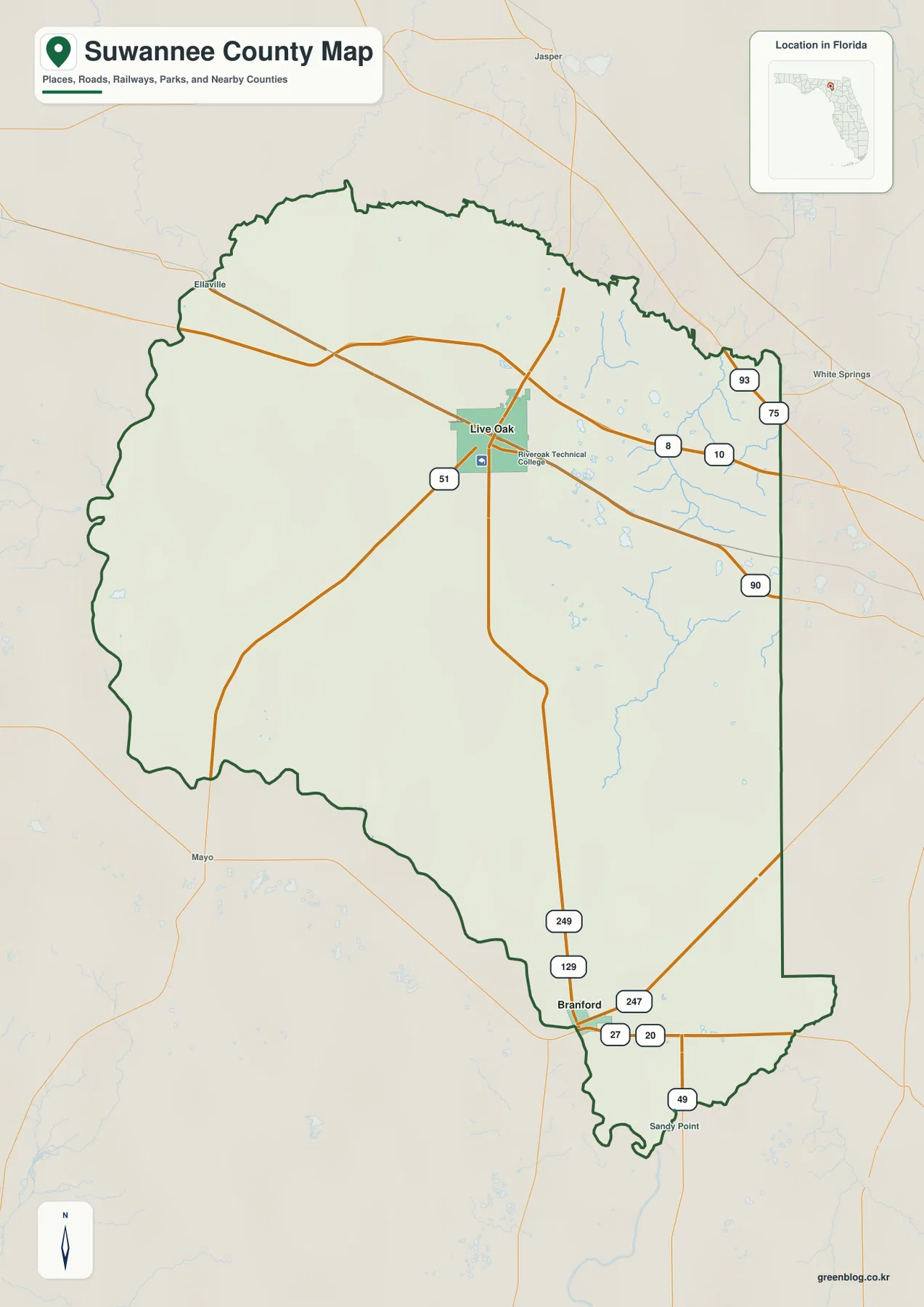
Places outside the boundary also help with orientation. Jasper appears to the north, White Springs to the east, and Mayo to the southwest. Those labels give a quick sense of the directions toward Hamilton, Columbia, and Lafayette counties. The western and southern edges are much less geometric because the Suwannee River forms a large part of the boundary, producing long bends instead of a simple straight line.
The city map shows how far apart Live Oak and Branford sit
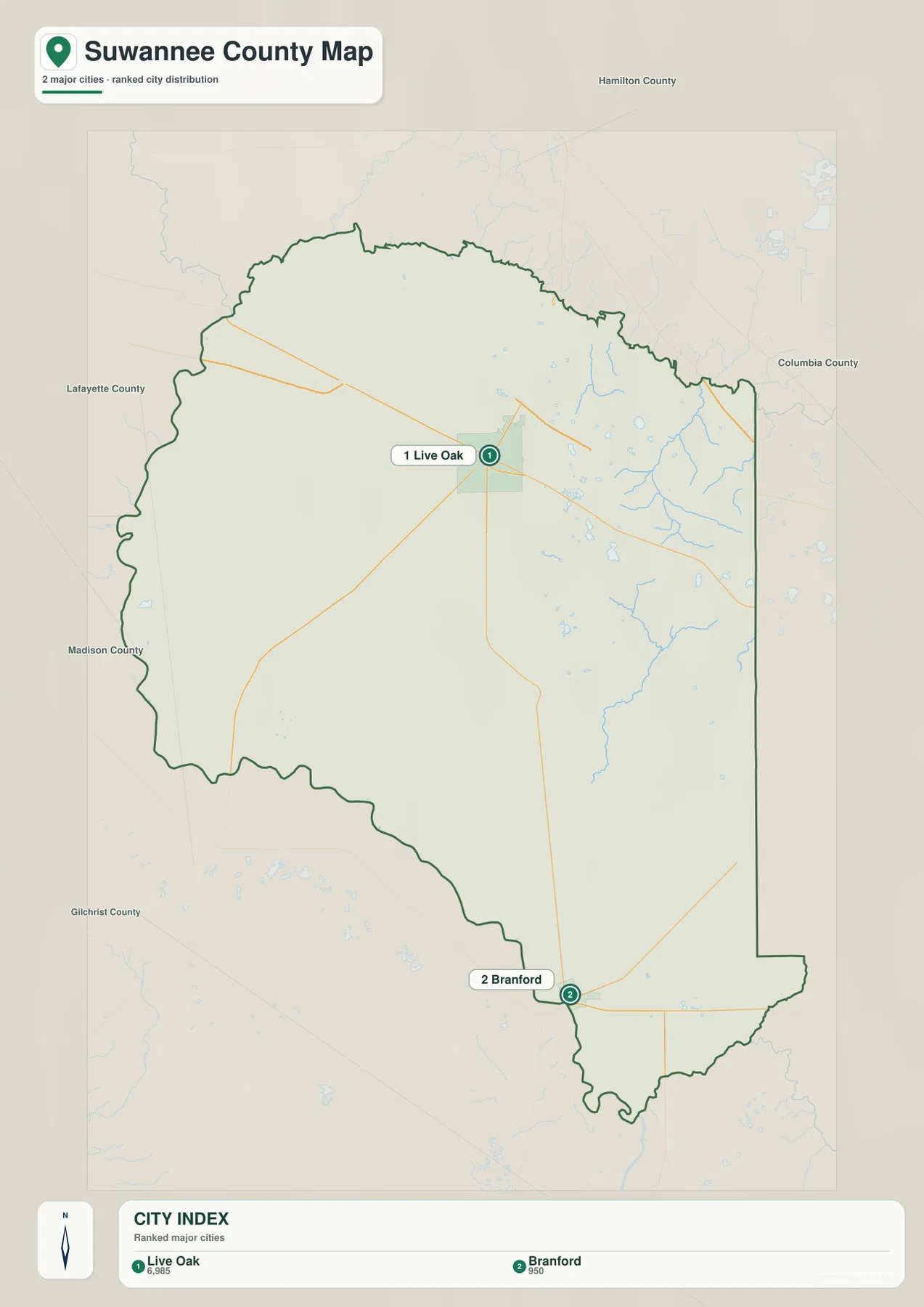
The city map removes most of the extra labels and focuses on the county’s two incorporated municipalities. Live Oak is marked in the northern half, while Branford sits close to the southern tip. Even without a distance label, the large amount of county land between the two markers makes it clear that these are not neighboring town centers. They serve different parts of a county with a broad rural interior.
The ranking printed on the map places Live Oak first and Branford second. The purpose of that view is not to replace the road map but to simplify the settlement pattern. Live Oak is the county seat and largest city, whereas Branford is a much smaller incorporated town near the southern river corridor. When the city map is compared with the county reference map, the importance of US 129 becomes especially obvious because it links the two municipal points across the length of the county.
Smaller communities still matter for understanding the space between those two cities. Existing county material identifies Wellborn southeast of Live Oak, McAlpin along the route toward Branford, O’Brien in the southeastern rural section, and Dowling Park on the Suwannee River to the west. These places help prevent the county from looking empty when the incorporated-city layer is simplified to only two labels.
Lakes and streams are concentrated in the eastern half of the water map
The terrain-and-water map changes the emphasis completely. In the northeast, the Suwannee River is labeled near the county edge. Moving south through the eastern interior, the map names Hare Lake, Lake Louise, Suwannee Lake, White Lake, and Peacock Lake. Rocky Creek bends through the same general area, creating a more intricate water network than the simpler road pattern suggests.
Farther south, Low Lake, Sand Pond, and Blue Lake appear around Crab Creek and Little River. The labels are useful because the names are spread across several small water features rather than one large central lake. Sears Lake stands farther to the southwest, showing that named water bodies are not limited to the eastern cluster even though that part of the map carries the densest set of stream and lake labels.
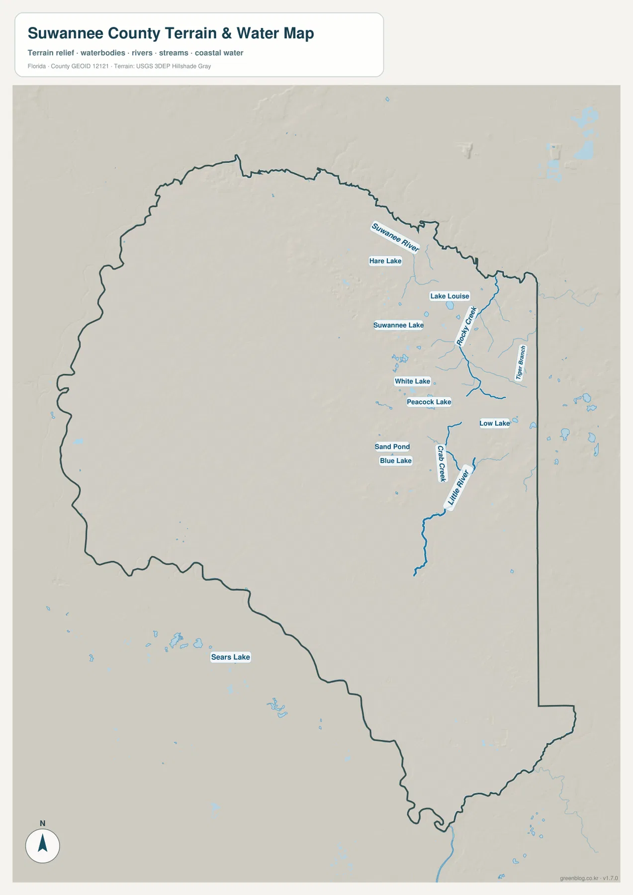
The shaded background is useful for broad terrain context, but it should not be treated as a survey or engineering elevation model. The blue features identify mapped water bodies and streams; they do not show live water levels, flood zones, navigation hazards, or property boundaries. For field use, the map works best as a location reference that is followed by current information from the relevant public agency.
South of Branford, river geography becomes the better guide
Near the southern end of Suwannee County, the boundary is easier to understand through rivers than through city names. Existing county material identifies the Santa Fe River joining the Suwannee south of Branford. The Ichetucknee River enters the Santa Fe farther east before that confluence. Keeping those relationships separate helps explain why several county directions come together in a relatively small area south of Branford.
Dowling Park and Branford are both useful Suwannee River references, but they are far apart within the county. Dowling Park is on the western side, while Branford is near the southern end. A straight-line glance at the river can therefore be misleading for travel: crossings are limited to particular roads and bridges, so a destination directly across the water may require a longer road route than the map distance suggests.
This river-defined boundary is one reason neighboring county maps are useful. Roads and waterways continue beyond Suwannee County into Hamilton, Columbia, Lafayette, Gilchrist, and other nearby counties. When a route or river leaves the page, comparing the adjoining county map helps preserve that geographic continuity instead of treating the county line as the end of the feature.
Choose the map by the question you need to answer
Use the county reference map when your main question involves roads, neighboring places, county boundaries, or the overall relationship between Live Oak and Branford. Use the city map when you only need the two incorporated municipalities without the visual clutter of every highway and water label. The terrain-and-water map is the better choice for the Suwannee River, Little River, Rocky Creek, Crab Creek, and the named lakes scattered through the eastern interior.
For a geography lesson or presentation, it can be useful to begin with the county reference map, locate Live Oak and Branford, and then switch to the water map to see how settlement and transportation relate to the river boundary and interior streams. For trip planning, the same comparison is useful as background, but the maps are not substitutes for live navigation, road-closure notices, parcel records, or current river conditions.
Frequently Asked Questions
Do I-10 and I-75 meet in downtown Live Oak?
No. I-10 passes north of Live Oak, while the I-10/I-75 interchange is farther east near the Columbia County line. Downtown Live Oak and the interstate junction should be treated as separate locations.
Which road gives the clearest route from Live Oak to Branford?
US 129 is the main north-south reference. It runs from Live Oak through the McAlpin area to Branford, where it meets the US 27 and SR 20 corridor.
Are Branford and Dowling Park both on the Suwannee River?
Yes, but they are in different parts of the county. Dowling Park is on the western side, while Branford is near the southern end, so they work as two separate riverfront reference points rather than one local cluster.
Which river joins the Suwannee south of Branford?
The Santa Fe River joins the Suwannee south of Branford. The Ichetucknee River enters the Santa Fe farther east before the Santa Fe reaches the Suwannee, so the three rivers should not be treated as one confluence point.
Map File Information
Download the Suwannee County reference map, city map, and terrain-and-water map as high-resolution A3 JPG files.
- Included Files: County map JPG, city map JPG, terrain-and-water map JPG
- File Type: Three JPG files in one ZIP archive
Related Maps
- A Sumter County Florida Map
- Arcadia Roads and Peace River | DeSoto County Florida Map
- Baker County Florida Map
Sources and References
These public resources provide additional context for Suwannee County population, roads, communities, and river recreation.
- U.S. Census Bureau – Suwannee County QuickFacts
- Florida Department of Transportation – I-10 Exit Information
- Florida Department of Transportation – I-75 Exit Information
- Suwannee County Communities
- Florida State Parks – Suwannee River Wilderness Trail
Green Map creates custom-edited map images using open geographic data sources such as geoBoundaries, Natural Earth, OpenStreetMap, and government open data.
These maps are edited visual materials, not raw data files, and are provided for education, documents, presentations, and graphic reference.