Bamberg County is easier to understand when the small towns, numbered roads, and rivers are viewed together rather than as separate facts. This Bamberg County Map page shows Denmark, Bamberg, Ehrhardt, Olar, and Govan within the county outline, then adds a city-connections view centered on Denmark and a terrain-and-water view built around the South Edisto and Salkehatchie river systems. The map files shown here can also be downloaded as high-resolution JPGs from the file box below.
The three supplied maps answer different practical questions. The general county map is best for seeing the boundary, settlements, and the numbered routes that connect them. The city-connections map measures straight-line distance from Denmark to Bamberg, Govan, Olar, and Ehrhardt, which makes the spacing of the county’s small communities easier to compare. The terrain-and-water map removes most of the road emphasis and brings forward the South Edisto River, Little Salkehatchie River, Salkehatchie River, named creeks, branches, swamps, and a small pond. Used together, the maps give a much fuller picture than the older outline-only article.
Table of Contents
Denmark and Bamberg organize the northern half of the county
On the county map, Denmark sits toward the northwest side of Bamberg County, while Bamberg is farther east in the northern central part of the county. Route 78 connects the two labeled places across the top half of the map, so their relationship is immediately visible. Around Bamberg, routes spread south and southeast as well as back toward the west. Denmark, by contrast, appears at a crossing of north–south and east–west roads, giving it a strong visual role even though the county bears the Bamberg name.
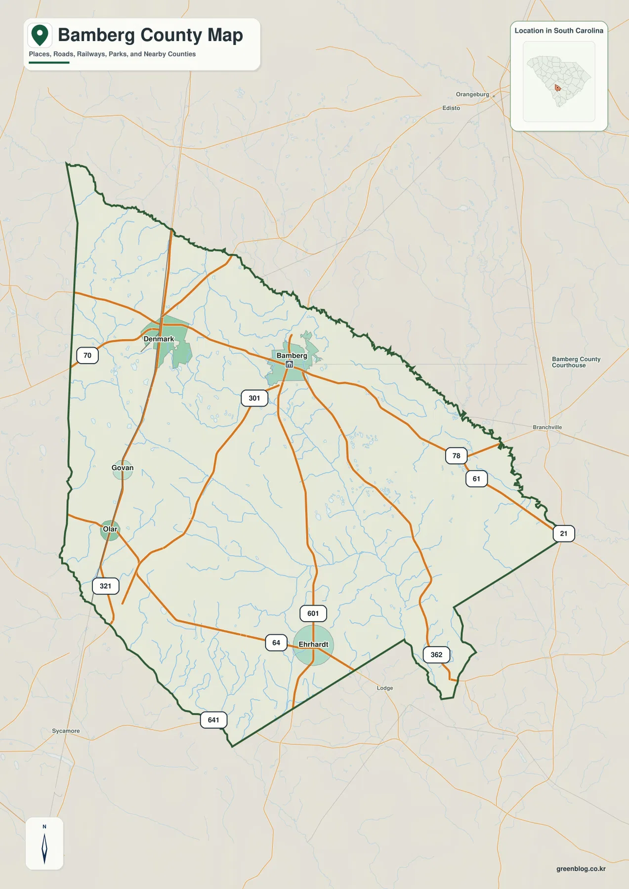
Ehrhardt provides a southern reference point. It appears near the junction of routes 64 and 601, well below Bamberg. Olar and Govan lie nearer the western side of the county, with route 321 running through that part of the map. Farther east, route 21 approaches the county edge, while route 61 and route 362 provide additional references southeast of Bamberg. The pattern is not one large urban center surrounded by continuous development. Instead, several small communities are separated by rural land and connected by a loose network of numbered roads.
The labels outside the boundary are useful too. Orangeburg County, Dorchester County, Hampton County, Barnwell County, Allendale County, and Colleton County appear around Bamberg County on the city-connections map. Those labels help place the county within the broader South Carolina landscape without requiring a separate state map. They also make it easier to understand why some roads continue beyond the county line in several directions. The northern boundary is irregular, while parts of the southern boundary are much straighter, so the shape itself changes noticeably from one side of the county to another.
Routes 78, 301, and 601 reveal how the small towns connect
The road pattern is most useful when read as a set of links between specific towns. Route 78 runs between Denmark and Bamberg and continues eastward. Route 301 passes through the northern central part of the county near Bamberg, while route 601 extends south from that area toward Ehrhardt. On the western side, route 321 gives Olar and nearby places a clear north–south reference. Other numbered routes, including 70, 61, 64, 362, and 641, fill in the network and make the county map far more informative than a simple boundary outline.
These roads should be used for county-scale orientation, not turn-by-turn navigation. The map does not attempt to show every local street, driveway, current construction zone, or traffic restriction. What it does well is answer questions such as whether Ehrhardt lies south of Bamberg, whether Olar and Govan are on the same side of the county, and how Denmark relates to the main east–west route across the north. For a report, school project, or county comparison, those relationships are often more important than a dense street layer.
The map also shows many small blue drainage lines crossing the road network. Even before switching to the dedicated water map, it is clear that roads repeatedly cross creeks and branches throughout the county. This is a useful reminder that Bamberg County’s transportation pattern and its waterways occupy the same landscape. The graphic should not be used to judge bridge condition or road access during a storm, but it does help a reader see why a road map and a water map tell complementary stories.
Straight-line distances from Denmark put the towns in perspective
The city-connections map chooses Denmark as the hub and places numbered markers on Bamberg, Ehrhardt, Olar, and Govan. Its table lists Bamberg at about 7 miles from Denmark, Govan at about 7 miles, Olar at about 10 miles, and Ehrhardt at about 17 miles. These are straight-line distances, not driving distances. A road trip between the same places may be longer because the route has to follow the road network rather than a direct line across the map.
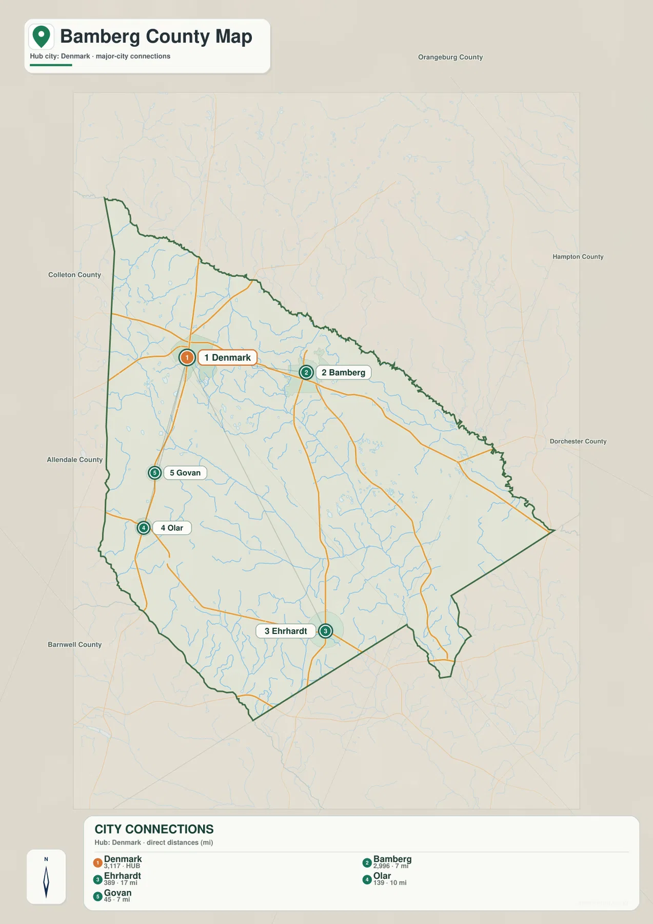
Those values add useful scale to what the eye sees. Bamberg and Govan are both relatively close to Denmark by the direct-distance measure, but they lie in different directions. Olar is farther south along the western side, and Ehrhardt is the most distant of the four labeled connections, positioned well into the southern half of the county. That combination of direction and distance is especially helpful in a county where the main settlements are small and spread out rather than merged into one continuous urban area.
The surrounding county names on this map also help explain outward travel. Orangeburg County appears above Bamberg County, while Allendale and Barnwell are labeled on the western and southwestern side; Hampton and Dorchester appear to the east, and Colleton is labeled to the west or northwest side of the frame. The purpose is not to give a complete regional highway plan, but to show that the county sits among several neighboring jurisdictions and that its local roads continue into a wider network.
Denmark’s role as the hub is a design choice of this particular city map, not a claim that every trip in the county begins there. If you want the administrative and road context around Bamberg itself, the general county map is more appropriate. If you want a quick comparison of town spacing, the Denmark-centered connection map is the clearer choice. Keeping those purposes separate prevents the distance labels from being mistaken for travel times or official routing information.
The South Edisto and Salkehatchie systems frame a dense water network
The terrain-and-water map changes the emphasis completely. Along the northeastern side of the county, the South Edisto River forms one of the clearest named water features. On the southwestern side, the Salkehatchie River provides another major reference, while the Little Salkehatchie River runs through the interior toward the south. These rivers give the county a water-based framework that is difficult to appreciate on the road map alone.
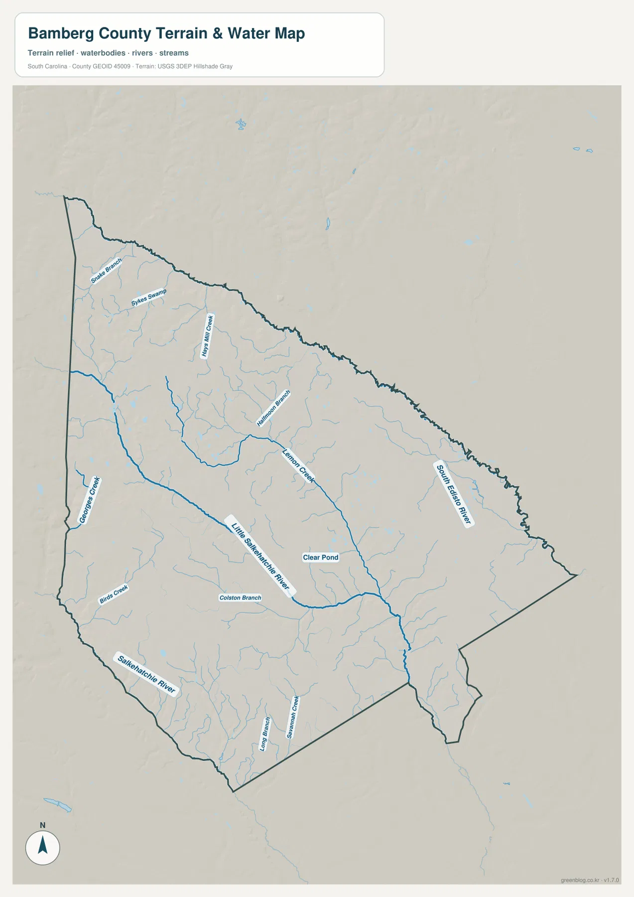
Several smaller names make the map county-specific. Kings Mill Creek and Halfmoon Branch appear in the northern and central parts of the county, Lemon Creek is labeled farther east, and Georges Creek provides a western reference. The northwest includes Snake Branch and Sykes Swamp, while Clear Pond is marked near the middle of the county. These names show that Bamberg County is not defined only by three large rivers; smaller creeks, branches, swampy areas, and ponds are spread across the same space where the towns and roads sit.
The South Edisto River is particularly useful for orienting the northeast side of the boundary. The Salkehatchie River, in contrast, helps define the southwest side, and the Little Salkehatchie River gives the interior a strong north-to-south water reference. Looking back at the county map after studying the water map makes many of the faint blue lines more meaningful. A road that first looked like a simple connection between towns can be seen crossing a series of smaller drainage channels before reaching another settlement.
This is a reference map of terrain and water, not a flood-hazard map, parcel map, navigation chart, or legal determination of a water boundary. The shaded surface is useful for seeing broad relief, but it is not survey-grade elevation information. If a decision depends on flood zones, property limits, engineering elevation, or current water conditions, use the appropriate official dataset. For ordinary map reading, however, this view provides a clear way to connect named rivers and creeks with the shape of Bamberg County.
Choosing the right Bamberg County view for the question you have
A reader looking for Denmark, Bamberg, Ehrhardt, Olar, or Govan should start with the general county map because the settlements and main numbered routes are visible together. Someone comparing the relative spacing of those towns should switch to the city-connections map, where the Denmark-based direct distances make the differences easier to quantify. For the South Edisto River, Little Salkehatchie River, Salkehatchie River, or named creeks and branches, the terrain-and-water map is the most direct source.
The maps are also useful side by side. Put the county map next to the water map and you can compare where route corridors cross drainage lines. Add the city-connections map and the location of each small town becomes easier to relate to those crossings. Denmark and Bamberg dominate the northern discussion, but Ehrhardt, Olar, and Govan prevent the county from being reduced to a two-town story. The southern and western parts of the county matter just as much when the full set is viewed together.
For printing, the downloadable JPG files preserve the original high-resolution versions. The WebP images in the article are intended as convenient previews, while the ZIP is the better choice when the map needs to be kept offline, inserted into a document at larger size, or compared with another county map. Because all three files cover the same county, a reader can move between road, settlement, and water information without having to reinterpret a different boundary each time.
| State | South Carolina |
|---|---|
| County | Bamberg County |
| Mapped communities | Denmark, Bamberg, Ehrhardt, Olar, Govan |
| City-map hub | Denmark |
| Major named waterways | South Edisto River, Little Salkehatchie River, Salkehatchie River |
| Download | ZIP with three original high-resolution A3 JPG maps |
The table is a quick index to the elements discussed above rather than a substitute for the maps. Use the county map when a numbered road or town is the target, the city-connections map when direct distance from Denmark matters, and the terrain-and-water map when a river, creek, branch, swamp, or pond is the target. That simple choice usually gets a reader to the right information faster than trying to force every question onto one crowded map.
Frequently Asked Questions
Why does the city-connections map use Denmark instead of Bamberg as the hub?
Denmark is the hub selected in the supplied city-connections map. Its distance table measures Bamberg, Govan, Olar, and Ehrhardt from that same point so the town spacing can be compared consistently. The figures are straight-line distances, not road mileage or travel time, so driving directions should be checked with a current road service.
Which map is best for finding the South Edisto and Salkehatchie rivers?
Use the terrain-and-water map. It labels the South Edisto River, Little Salkehatchie River, and Salkehatchie River along with smaller features such as Lemon Creek, Kings Mill Creek, Halfmoon Branch, Georges Creek, Sykes Swamp, and Clear Pond. The general county map contains many blue drainage lines, but the water-focused map makes the names and relationships much easier to follow.
What is included in the Bamberg County download ZIP?
The ZIP contains the three map types actually supplied for this county: the general county map, the Denmark-centered city-connections map, and the terrain-and-water map. Each is provided as an original high-resolution A3 JPG. The WebP images in the article are preview versions for quick viewing on the page.
Map File Information
The county map, city-connections map, and terrain-and-water map shown on this page are available as the original high-resolution A3 JPG files. The ZIP contains the three JPG maps supplied for this county.
- Included Files: county map, city-connections map, terrain-and-water map
- Printable Size: original high-resolution A3
- File Type: JPG
Related Maps
Sources and Reference Data
The article is based primarily on the three Bamberg County maps supplied in the package. The following official sources are useful for checking county information, boundary data, and water features in more detail.
- South Carolina Association of Counties – County Information
- SCAC County Directory Pages
- U.S. Census Bureau TIGER/Line Shapefiles
- USGS National Hydrography
- South Carolina Geological Survey
Green Map creates custom-edited map images using open geographic data sources such as geoBoundaries, Natural Earth, OpenStreetMap, and government open data.
These maps are edited visual materials, not raw data files, and are provided for education, documents, presentations, and graphic reference.