You can use the Barnwell County Map on this page as a quick reference and then download the matching high-resolution A3 JPG files in a single ZIP. Barnwell is the easiest place to orient yourself because several major numbered roads meet near the county seat, while Williston, Blackville, Hilda, Elko, Snelling, and Kline spread across the northern, central, and southern parts of the county. The three provided views are not duplicate designs: one emphasizes roads and the county boundary, one simplifies the scene so the main towns are easier to compare, and one focuses on rivers, creeks, ponds, and broad terrain relief.
Barnwell County lies in inland southwestern South Carolina. Its outline is irregular on the west and south rather than forming a simple rectangle, and Barnwell itself sits east of the county’s geographic center. The road-and-town detail becomes denser around Barnwell, Hilda, and Blackville, while the western side is visually quieter on the general map and much more distinctive on the water map because of Par Pond and nearby ponds. Moving between the three maps makes the county easier to understand than relying on the boundary alone.
Table of Contents
Barnwell as the road reference for the county
Start with Barnwell on the general county map. Route 70 heads toward Hilda, Routes 3 and 278 continue south toward the Kline area, and Route 64 reaches toward the southeastern edge. Route 37 provides an important northbound reference through the interior, while Routes 78 and 304 are prominent near Blackville. Farther southwest, Route 125 crosses a much less urban-looking part of the county. The value of the map is not in memorizing every route number; it is in seeing how the roads fan away from Barnwell and connect the county seat with towns that are otherwise separated by long rural stretches.
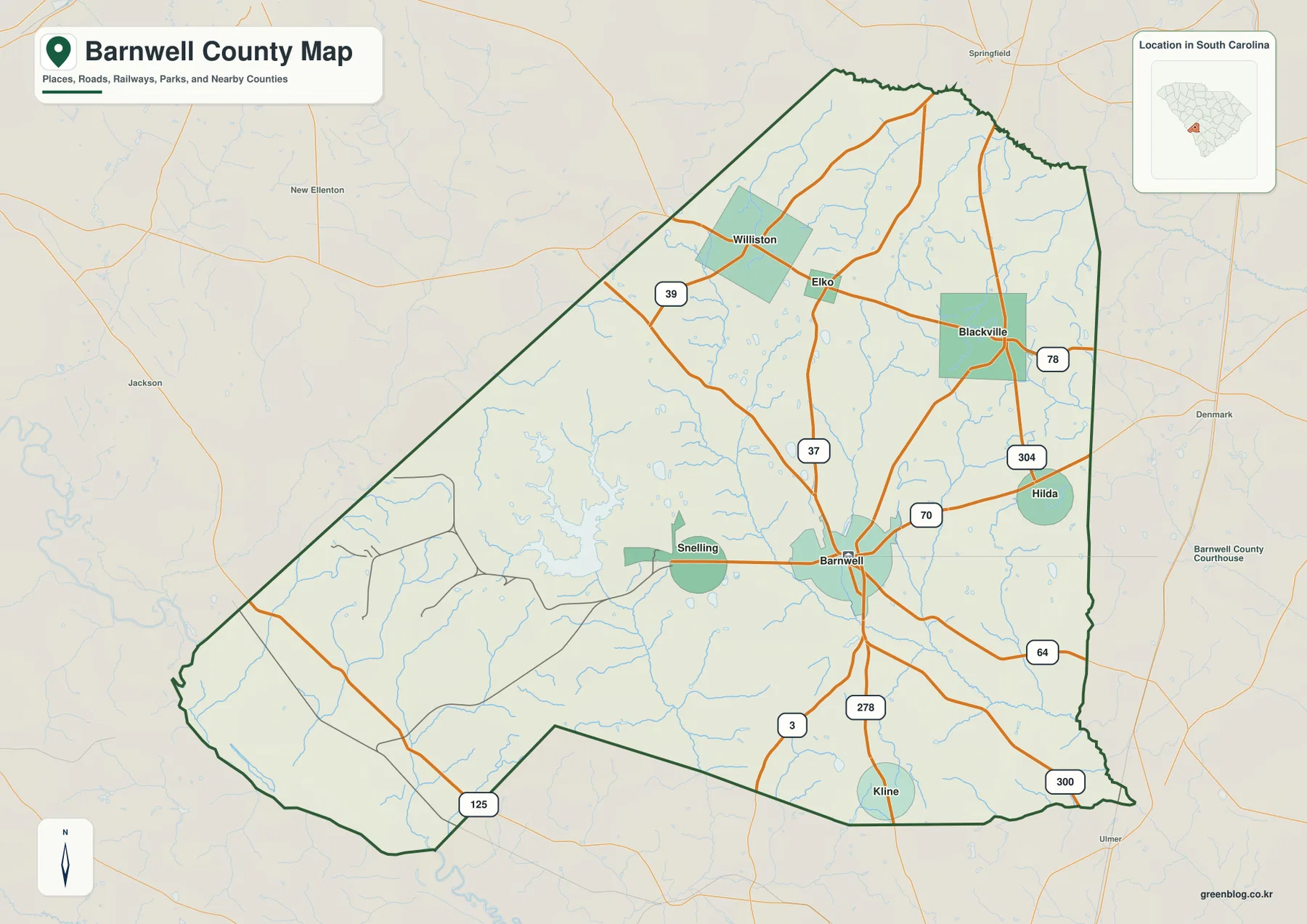
The neighboring county labels help place Barnwell County within the region. Aiken County lies beyond the northwestern side, Allendale County is to the west, Bamberg County is on the eastern side, and Orangeburg County reaches the southeast. The western boundary bends inward before widening again, and the southern edge has several changes in direction. Those features make the outline recognizable when Barnwell County is viewed beside other South Carolina counties. On the eastern half of the map, the towns and roads approach the boundary more closely, which makes Blackville and Hilda useful landmarks when comparing Barnwell with Bamberg County.
This is a locator map rather than a street-by-street navigation map. It works best for questions such as where Barnwell sits relative to Williston, how Blackville connects back toward the county seat, or which major route reaches the southern part of the county. For a report, classroom handout, or county comparison, the combination of boundary, place names, and major roads gives enough context without the visual clutter of every local road.
The town pattern from Williston to Snelling
The city distribution map reduces road detail and gives more space to six ranked places. Barnwell is marked as number 1, followed by Williston, Blackville, Hilda, Elko, and Snelling. The city index printed at the bottom lists values of 4,613 for Barnwell, 2,870 for Williston, 1,778 for Blackville, 468 for Hilda, 296 for Elko, and 219 for Snelling. These figures are best treated as the ranking values used in the map rather than as a substitute for a current population table. Their main purpose here is to explain why some place labels receive more visual emphasis than others.
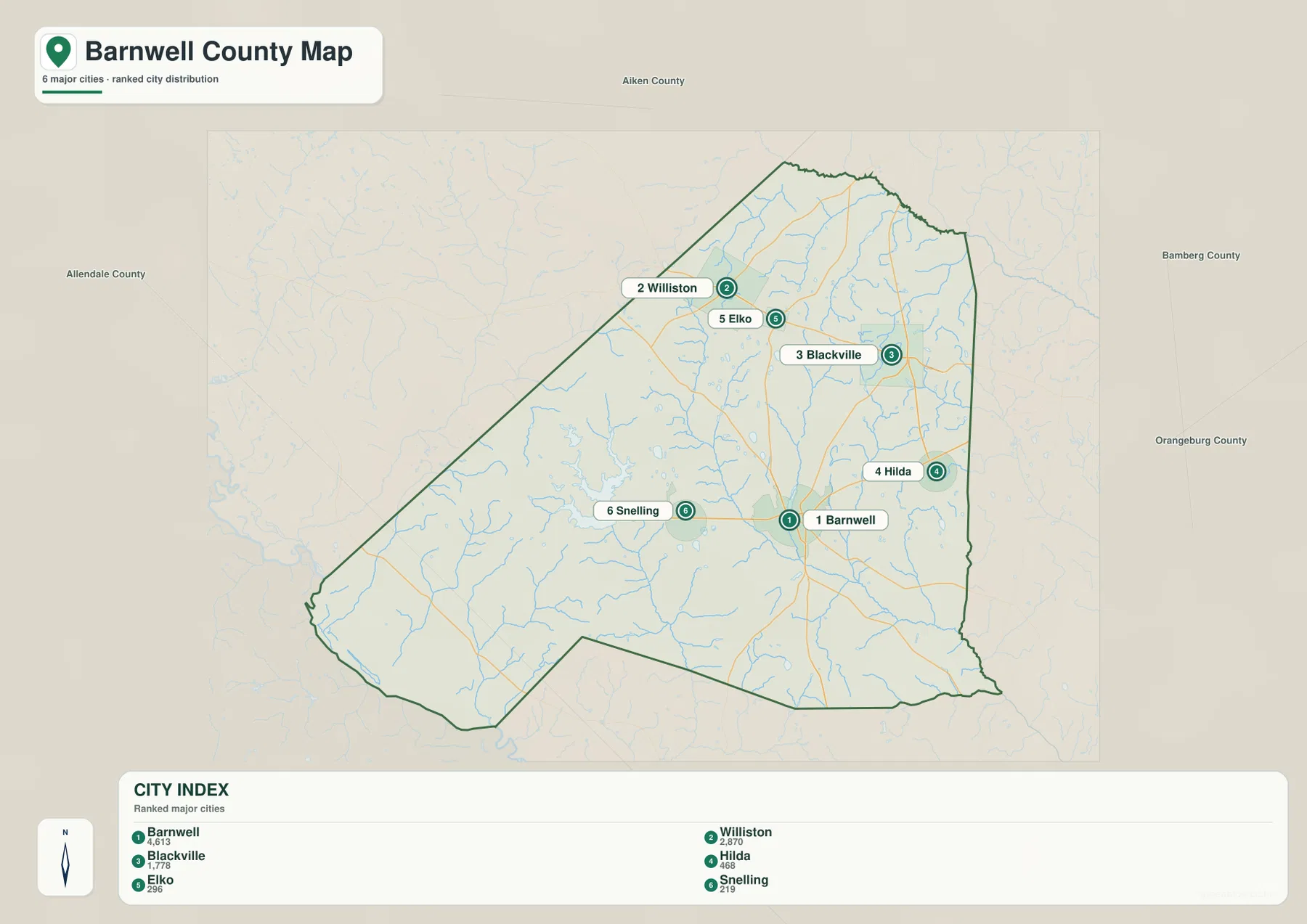
The six labels form two loose groups that are easy to recognize. Williston and Elko sit near one another in the north, with Blackville farther east. Barnwell is well south of that group, Hilda is a short distance to its northeast, and Snelling lies close to the west. Kline appears on the general county map near the southern edge but is not included in the six-place ranking, so comparing the two maps also shows the difference between a full locator map and a selected city summary.
The neighboring county names printed around the map provide another layer of orientation without adding more roads. Aiken is beyond the northwestern side, Allendale lies west, Bamberg east, and Orangeburg southeast. Readers who are unfamiliar with Barnwell County can therefore find Barnwell first, move up to the Williston–Elko–Blackville group, and then relate the entire county to its neighbors. That sequence is often easier than trying to learn the towns from an alphabetical list.
Par Pond, the Edisto branch, and the Salkehatchie waterways
The terrain-and-water map changes the visual hierarchy completely. The South Fork Edisto River crosses the northern part of the county, while the Salkehatchie River curves through the middle and continues toward the southeastern boundary. Tinker Creek and Toby Creek are clearly labeled on the eastern side, Fountain Branch appears at the western edge, and Steel Creek is marked in the southwest. Numerous smaller blue lines connect to these named waterways, making it clear that areas that look relatively empty on the road map are actually divided by a dense drainage network.
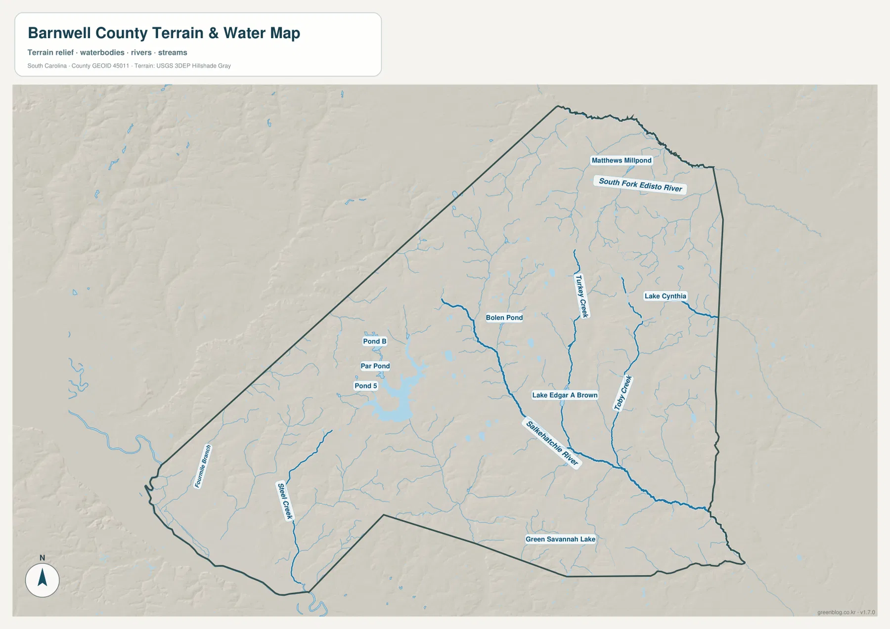
The most obvious group of larger water bodies is in the west-central part of the county. Par Pond sits close to Pond 5 and Pond B, creating a cluster that remains easy to identify even when the map is viewed at a smaller size. Bolen Pond lies northeast of that group. Farther east, Lake Edgar A Brown and Lake Cynthia provide separate named references, while Green Savannah Lake appears near the southern boundary and Matthews Millpond is labeled in the north. The result is not a county with one dominant lake; instead, several named ponds and lakes are spread across different parts of the map, with the Par Pond group forming the strongest visual concentration.
The shaded relief is gentle rather than mountainous. Broad tonal changes suggest low rolling terrain, with somewhat stronger relief visible outside the western and northwestern edges, but there are no contour lines or spot elevations on this map. It is therefore useful for understanding how the water network sits within the landscape, not for measuring the exact elevation of a road, house, or stream crossing. For precise elevation work, a separate elevation dataset would be required.
Using the previews and the downloadable A3 files
Choose the map according to the question you need to answer. The general county map is the fastest reference for the boundary, Barnwell, major towns, and numbered routes. The ranked city map is cleaner when the goal is to compare the positions of Williston, Blackville, Barnwell, Hilda, Elko, and Snelling. The water map is the better choice for the South Fork Edisto River, Salkehatchie River, creeks, Par Pond, and the other named water bodies. Because the emphasis changes from one file to the next, using the right map is more effective than forcing one view to answer every type of question.
The WebP images embedded in the article are optimized for browser viewing. The download box below provides the matching A3 high-resolution JPG versions, so readers who need to print the maps, enlarge small route labels, inspect thin stream lines, or place the maps in a report can work from the original files instead of taking screenshots. You can preview the subject first and then download the ZIP only when you know which file you need.
Frequently Asked Questions
Where is Williston in relation to Barnwell?
Williston is well north of Barnwell and is close to Elko in the northern part of the county. The general county map is useful when you also want to see the major road connections, while the ranked city map makes the separation between the northern towns and Barnwell easier to compare without as much road detail.
Why is Par Pond easy to find on the water map?
Par Pond is part of a noticeable west-central cluster with Pond 5 and Pond B. Those broader water shapes stand out from the finer creek network elsewhere in the county, so the group remains visible even at a reduced map size. Bolen Pond is labeled northeast of the cluster.
What is included in the Barnwell County download ZIP?
The package contains three A3 high-resolution JPG files: the general county map, the ranked city map, and the terrain-and-water map. They correspond to the WebP previews shown on this page but are better suited to printing, enlarging labels, and placing the maps in documents or presentations.
Map File Information
The ZIP contains high-resolution A3 JPG versions of the Barnwell County general map, city distribution map, and terrain-and-water map. Use the originals when you need a larger image than the WebP previews shown on this page.
- Included Files: county map JPG, city map JPG, terrain-and-water map JPG
- Printable Size: high-resolution A3
- File Type: ZIP containing three JPG files
Related Maps
Sources and reference data
- South Carolina Association of Counties – County Information: county background and administrative reference.
- U.S. Census Bureau TIGER/Line Shapefiles: official boundary, road, and place-reference data.
- USGS National Hydrography: official reference for rivers, streams, lakes, and ponds.
- USGS 3D Elevation Program: elevation reference used for shaded terrain.
- South Carolina Geological Survey: statewide physical-geography and mapping reference.
Green Map creates custom-edited map images using open geographic data sources such as geoBoundaries, Natural Earth, OpenStreetMap, and government open data.
These maps are edited visual materials, not raw data files, and are provided for education, documents, presentations, and graphic reference.