Download the high-resolution Steuben County JPG maps in one ZIP from the file box below. The archive contains the general county, city, terrain-and-water, and elevation views at 3638×2572 pixels each. On the page, the maps show Angola at the center of the road network, Fremont and the lake country to the north, Orland to the northwest, Clear Lake at the northeastern edge, and Hamilton in the southeast. They also show how Lake James, Jimmerson Lake, Crooked Lake, Snow Lake, western creeks, and a 266–366 meter relief surface fit together across the county.
This Steuben County Indiana Map set is easiest to follow from Angola. I-69 runs north–south near the city, while US 20 crosses east–west. Fremont lies north along the interstate side, Orland is farther northwest, Clear Lake occupies the northeastern corner, and Hamilton sits well to the southeast. The major lake cluster northwest of Angola gives the county a second reference system that is just as important as the roads.
The elevation map shows why the northern lake district is not simply flat lake country. Its legend reports an actual range of about 266 to 366 meters and a mean of 305 meters. Lower green ground is common across the west and parts of the south, while tan and brown hills become much more extensive through the northeast and north-central interior. Lakes and stream valleys occupy lower corridors between those ridges.
Table of Contents
Angola ties I-69 and US 20 to the county’s outer communities
Angola is the clearest starting point on the general county map. I-69 runs north–south through the central part of the county, while US 20 crosses through Angola from west to east. Once those two roads are located, Fremont, Orland, Clear Lake, Hudson, Ashley, and Hamilton fall into clear directions around the county center.
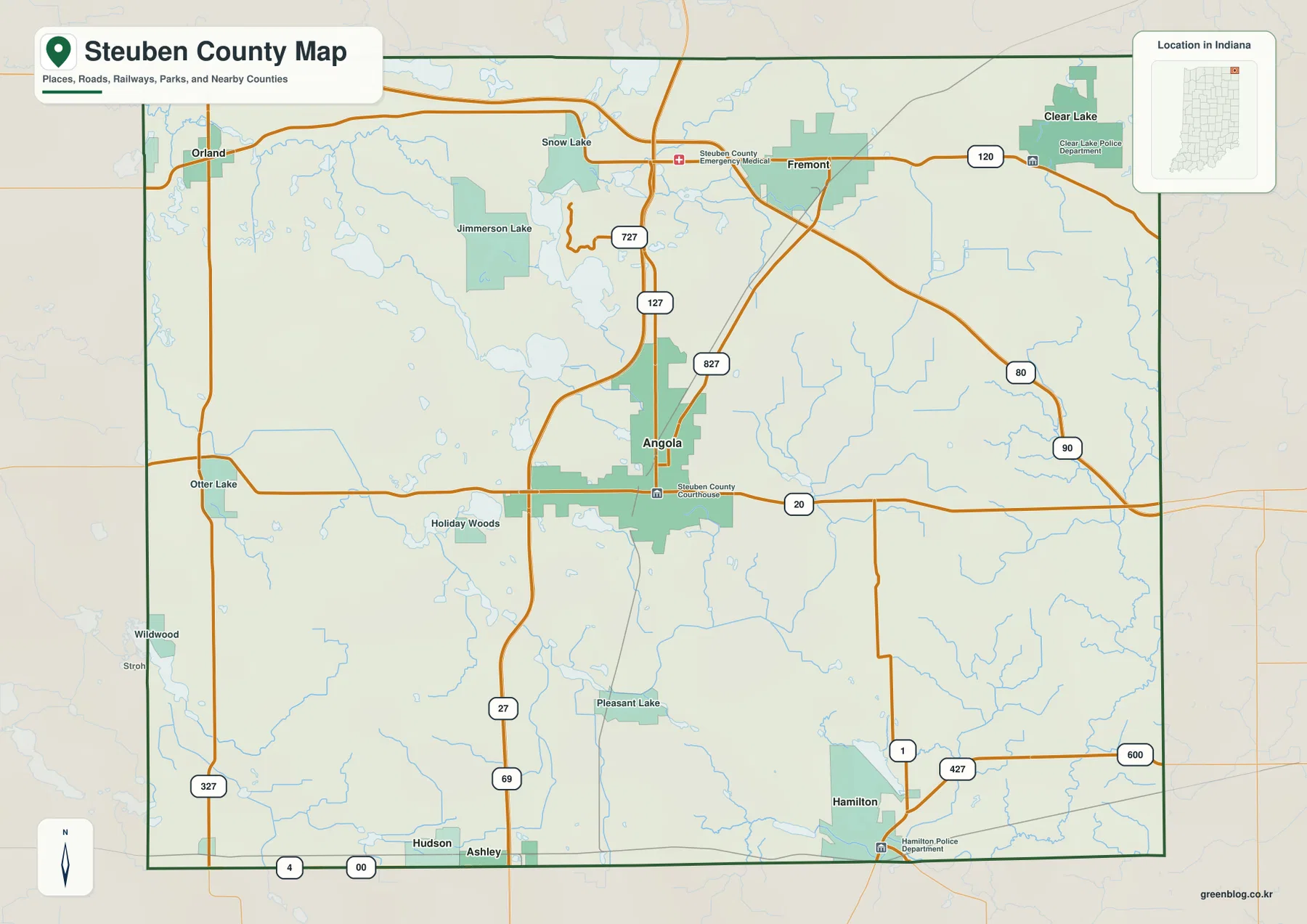
Fremont is the main northern road reference because it sits close to I-69. Orland is farther west, and Clear Lake stands apart near the northeastern edge. Although all three are northern communities, they occupy different directions rather than forming one continuous settlement line. That spread becomes obvious when Fremont is used as the middle reference.
South of Angola, Hudson and Ashley lie close to the county line, while Hamilton is farther southeast. Roads marked 1 and 427 appear near Hamilton, with Otter Lake and Wildwood providing additional western references. The southern half has wider gaps between major place labels and fewer large lakes than the north.
The general map is useful for route direction, place names, county boundaries, and nearby lakes, but it is not a live traffic product. Current construction, closures, and travel restrictions should be checked with a current transportation source. Here, the map is best used to understand how Angola connects with the outer communities.
The highlighted communities spread outward from Angola in nearly every direction
The city map highlights Angola, Fremont, Hamilton, Hudson, Clear Lake, and Orland. Angola sits near the center, Fremont lies north, Clear Lake is northeast, and Orland is northwest. Hamilton is far to the southeast, while Hudson sits near the southern boundary. This produces a broad countywide distribution rather than one narrow urban corridor.
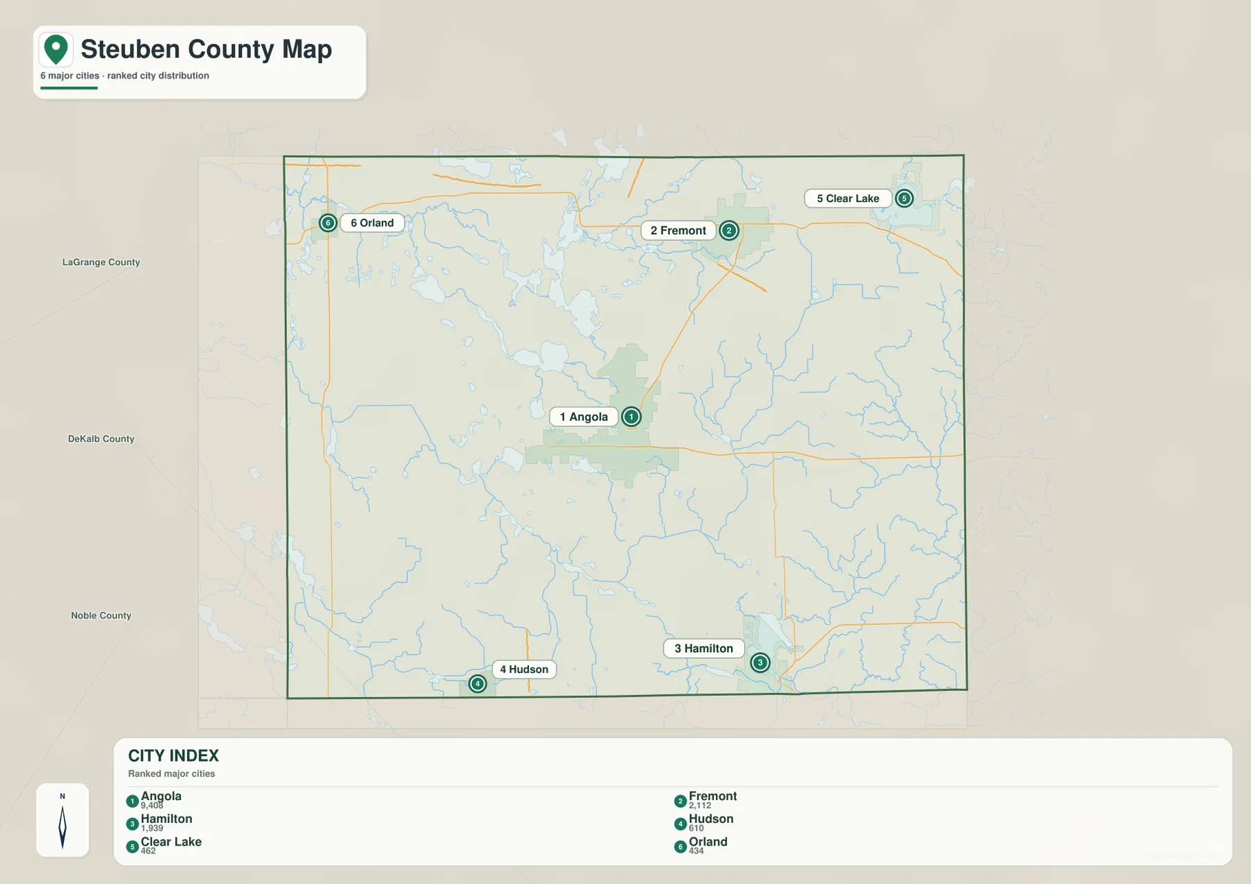
The CITY INDEX includes numeric values beside the six place names, but the supplied package does not identify the year or provide a separate statistical source. This article therefore does not present those numbers as current official population. A current U.S. Census product should be used when up-to-date population is required; here, the city map is used for the verified location of the highlighted communities.
LaGrange County is labeled to the west and northwest, with DeKalb and Noble counties farther south and southwest in the surrounding view. Orland lies close to the western edge, Clear Lake reaches the northeastern side, and Hamilton approaches the southeastern boundary. Those edge communities make the county’s full extent easier to understand.
The same city pattern helps place the lake country. Jimmerson Lake, Lake James, and Crooked Lake lie northwest of Angola, Snow Lake is farther north toward Fremont, and Clear Lake stands apart in the northeast. Hamilton is closely associated with Hamilton Lake in the southeast. Remembering the town locations makes the water map much easier to organize.
Lake James, Snow Lake, and Crooked Lake define the northern lake district
The terrain-and-water map is dominated by the concentration of lakes across the north and northwest. Lake Pleasant is labeled near the northern edge, with Snow Lake farther south. Jimmerson Lake, Lake James, and Crooked Lake form a close cluster northwest of Angola. They sit near one another but are shown as separate named water bodies rather than one continuous lake.
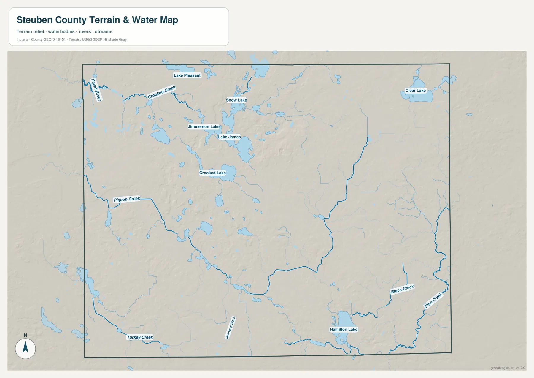
Clear Lake is separated from the main northern cluster in the northeast, while Hamilton Lake is the strongest southeastern water reference. The western side contains more linear water features: Fawn River follows the northwestern side, Crooked Creek crosses the upper interior, Pigeon Creek runs through the west-central area, and Turkey Creek appears farther south.
Black Creek and Fish Creek are labeled near the Hamilton Lake area, while Wilson Ditch appears farther west in the southern interior. The county therefore combines a dense lake district with natural creeks and a named drainage ditch. A practical way to read the map is to separate the northern lakes, western creek country, and Hamilton Lake side before looking at smaller water features.
This is a county-scale water reference rather than a flood map, parcel map, legal water-boundary product, depth chart, drainage-engineering plan, or navigation guide. It is useful for locating the named lakes, rivers, creeks, and ditch and comparing them with roads and communities. Current flood conditions, boating questions, or site-specific water decisions require dedicated agency data.
The 266–366 meter surface places the highest broad terrain in the north and northeast
The elevation legend reports an actual Steuben County range of about 266 to 366 meters and a mean of 305 meters. Green represents lower terrain within the county-scale display, shifting through yellow and tan to brown at higher elevations. The west and parts of the south are broadly lower, while the northeast and north-central interior contain the most extensive brown high ground.
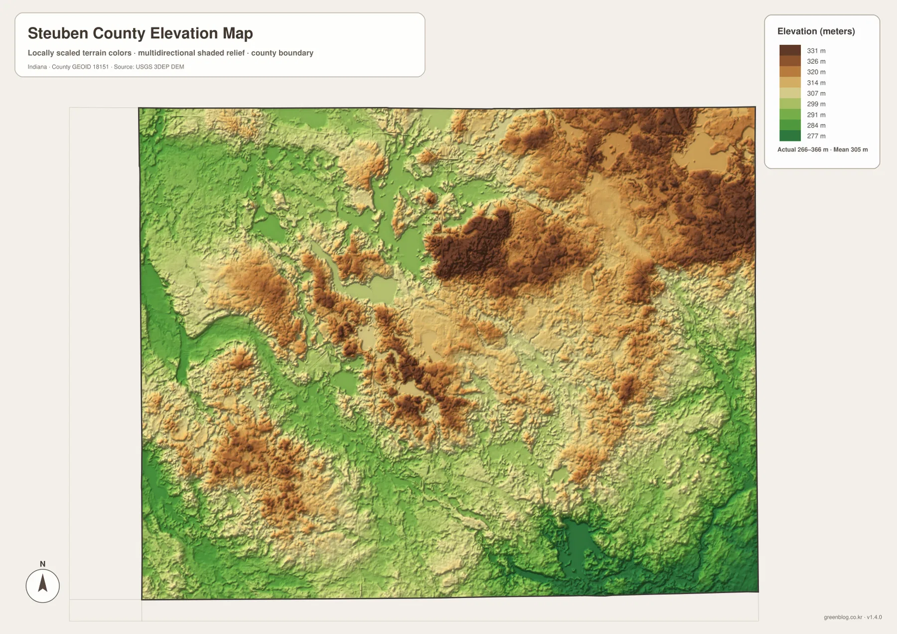
The northern lake district contains repeated short-distance changes in height. Around Lake James, Jimmerson Lake, and Crooked Lake, lower green basins lie immediately beside tan and brown ridges. Farther east and northeast, the high terrain becomes broader and darker. The result is a landscape of lake basins and rolling hills rather than a flat lake plain.
Western Steuben County is lower overall, with stream valleys associated with Fawn River, Pigeon Creek, and Turkey Creek. The south also contains broad lower ground, including the Hamilton Lake area. The county is therefore better understood as a mix of western and southern lowlands beside higher northern and northeastern ridges.
The elevation map is intended for county-level comparison rather than survey-grade measurement. It should not be used to assign an exact elevation to a building, road point, parcel, or construction site. The range and mean are useful regional reference values, but precise site elevations require source data or professional survey measurements.
Use Angola as the fixed point when comparing roads, lakes, and relief
For ordinary orientation, begin with the general county map and locate Angola, Fremont, I-69, and US 20. The city map is cleaner when the goal is simply to compare Orland, Clear Lake, Hamilton, Hudson, and Fremont around the county center. Returning to the road view after that makes the outer routes easier to place.
For water features, use the terrain-and-water map to locate Lake James, Jimmerson Lake, Crooked Lake, Clear Lake, Fawn River, and Pigeon Creek. Then find the same areas on the elevation map. The northern lake district contains short-distance changes between low lake basins and higher ridges, while the western creek corridors remain broadly lower.
The WebP previews are optimized for browser viewing. The downloadable ZIP contains the original high-resolution JPG versions of the general county map, city map, terrain-and-water map, and elevation map. Each file is a landscape image measuring 3638 by 2572 pixels, making the originals better for enlarging small route and creek labels or preparing an A3 print.
A practical comparison routine is to keep Angola fixed as the reference point. Find I-69 and US 20 on the general map, compare Fremont, Orland, Clear Lake, and Hamilton on the city view, then trace the northern lake district and western creeks on the water map. Finish with the elevation image and compare the lower western greens with the higher northeastern browns.
Frequently Asked Questions
What is the easiest place to use as a starting point on the Steuben County maps?
Angola is the most useful starting point because I-69 and US 20 are easy to identify there. Fremont lies to the north, Orland to the northwest, Clear Lake to the northeast, and Hamilton to the southeast. Keeping Angola fixed also makes the northern lake district easier to place.
Are Lake James, Jimmerson Lake, and Crooked Lake one connected lake?
No. The supplied water map labels Lake James, Jimmerson Lake, and Crooked Lake separately, even though they occupy the same broad northern lake district. Snow Lake and Lake Pleasant are farther north, while Clear Lake stands apart in the northeast.
Where does the elevation map show the highest-looking terrain?
The broadest brown high ground appears in the northeast and north-central interior. The west and parts of the south are lower and greener. The legend reports an actual range of about 266–366 meters and a mean of 305 meters.
Map File Information
Download the high-resolution JPG originals for the Steuben County general map, city map, terrain-and-water map, and elevation map in one ZIP. Use the originals when small road or creek labels need to remain clear or when preparing an A3 print.
- Printable Size: 3638×2572 px each
Related Maps
Sources and References
The road, settlement, water, and elevation descriptions above are based on the supplied Steuben County maps and asset information. The official resources below are useful when source boundary, hydrography, or elevation data is needed.
- U.S. Census Bureau TIGER/Line Shapefiles – official county boundary, road, and place reference data
- USGS National Hydrography – official river, creek, lake, and ditch data information
- USGS 3D Elevation Program – elevation source data and program information
Green Map creates custom-edited map images using open geographic data sources such as geoBoundaries, Natural Earth, OpenStreetMap, and government open data.
These maps are edited visual materials, not raw data files, and are provided for education, documents, presentations, and graphic reference.