Webster County is a rural county in north-central Mississippi where the most useful map references are not all in the same place. Eupora stands out in the south-central part of the county because US 82 passes through it, while Walthall, the county seat, is a smaller community a few miles to the north near MS 9. Mathiston lies farther east along the US 82 corridor, and Mantee provides a reference point near the northeastern side of the county.
This page is both a map guide and a download page. You can compare the county boundary and road network, Eupora-centered community connections, Big Black River headwaters and named creeks, and the county’s ridge-and-valley elevation pattern on screen. If you need files for printing, class materials, a presentation, or a local reference document, one downloadable ZIP contains four high-resolution A3 JPG maps. The download box appears below the map guide, so you can identify the view you need and then save the full-resolution JPG files rather than relying on the WebP previews.
Table of Contents
Use Walthall and Eupora to orient the county
The county map shows an outline that is broad across the west and more stepped and irregular along the eastern side. Eupora is marked in the south-central portion, with Mathiston to the east, Mantee close to the northeastern edge, and Walthall north of Eupora. Neighboring county names around the frame include Calhoun, Chickasaw, Oktibbeha, Clay, Choctaw, Montgomery, and Grenada, which makes it easier to understand Webster County’s position without switching immediately to a statewide map.
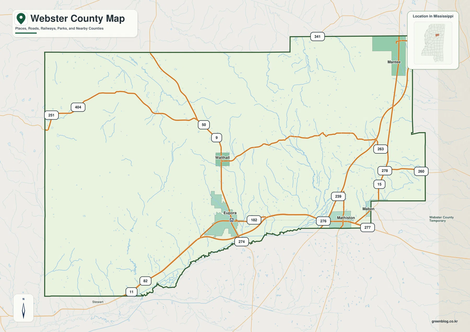
US 82 is the strongest east-west reference across the southern part of Webster County. It enters from the west, reaches Eupora, and continues toward Mathiston and eastern Mississippi. MS 9 runs north from the Eupora area toward Walthall, while MS 15 provides a north-south reference near the eastern side. The map also labels routes such as MS 50 and MS 341. In a county with many rural addresses and relatively few large settlements, these numbered roads can be more useful than town names when the goal is to identify a particular side of the county.
- County seat: Walthall
- Prominent mapped communities: Eupora, Walthall, Mathiston, and Mantee
- 2020 census population: 9,926
- July 2025 population estimate: 10,167
- 2025 Gazetteer land area: 421.158 square miles
- 2025 Gazetteer water area: 2.071 square miles
Those figures come from different reference dates, so the population count, later estimate, and land-area value should not be treated as one single-year snapshot. They still provide useful scale. The relatively small listed water area is also consistent with what the physical maps show: Webster County’s water geography is dominated by narrow creeks and branching tributaries rather than a large lake occupying a major part of the county.
Eupora connects the southern road corridor to smaller communities
The city-connections map treats Eupora as the hub and compares it with three other named communities. Mathiston is shown about 8 miles east of Eupora, Walthall about 4 miles north, and Mantee about 17 miles to the northeast. These figures are straight-line distances between mapped points. They are useful for understanding direction and relative spacing, but they are not road mileage and should not be used to estimate travel time without checking the actual route.
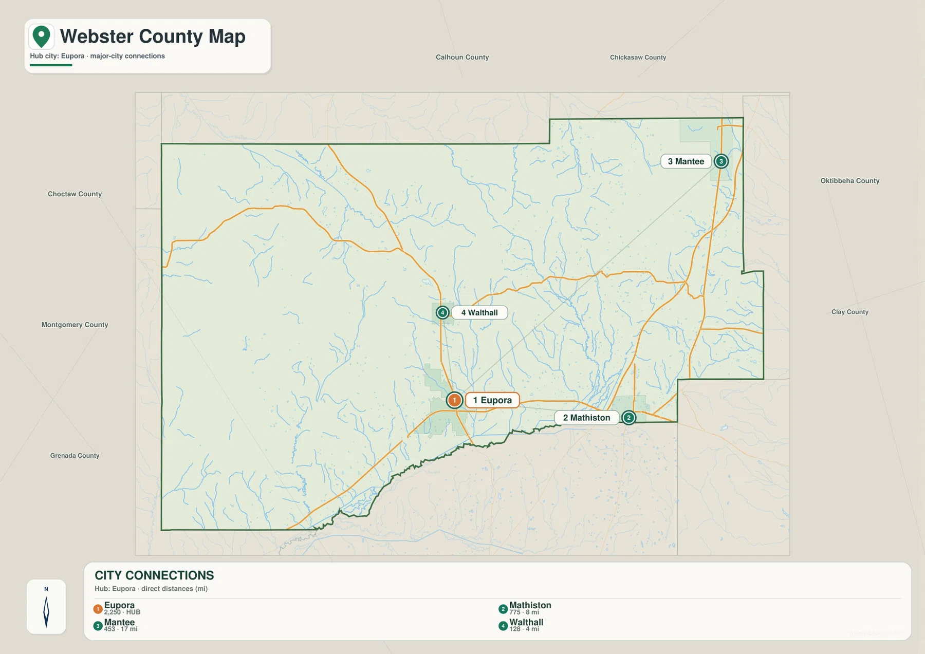
Eupora looks prominent because it is the larger settlement and lies directly on US 82, not because it is the county seat. Walthall has the administrative role but sits away from the main east-west highway. That distinction matters when reading local addresses or planning a visit. A courthouse or county-government destination can direct a visitor toward Walthall, while through travel and many everyday community references are easier to understand from Eupora and the US 82 corridor.
Mathiston gives the southeastern side another clear landmark along US 82, while Mantee helps define the northeastern side of the county. The western half has fewer large community labels, so a rural location there may be easier to place by matching a numbered road with a creek or the county boundary. Using the road map and the city map together is therefore more helpful than expecting every rural place to be represented by a town name.
Small creeks lead toward the Big Black River headwaters
The water map is filled with fine tributary lines. The Big Black River is the strongest named channel near the southeastern and southern side, but the interior of Webster County is shaped by many smaller streams that descend through the hills. Sabougla Creek crosses the north-central area, Little Black Creek runs south through the middle, Whites Creek follows a nearby valley, and Spring Creek descends through the eastern interior toward lower ground near the Big Black River. Numerous unnamed tributaries branch away from those channels.
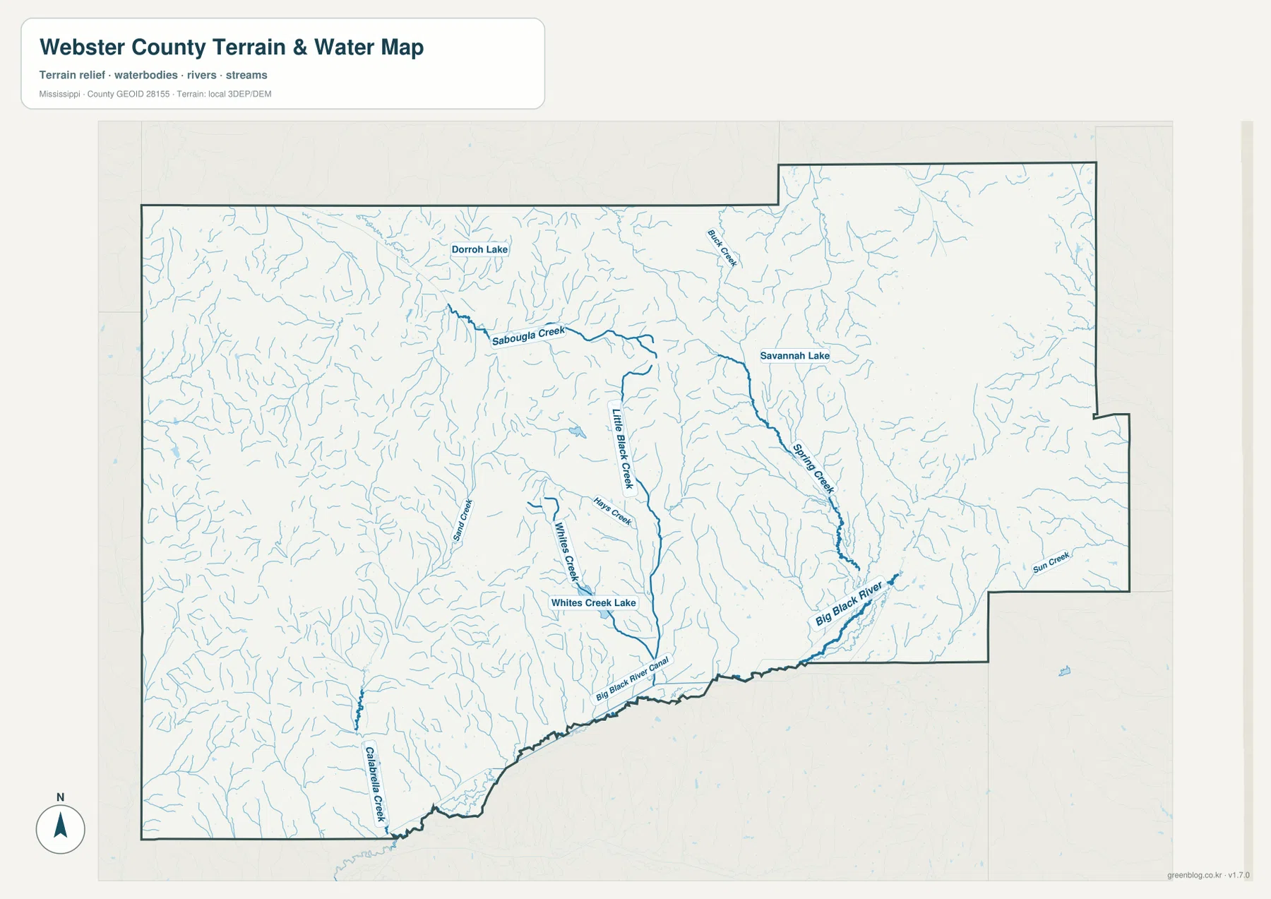
Dorroh Lake, Savannah Lake, and Whites Creek Lake are labeled as local water features, but none appears large enough to dominate the county map. The practical value of this view is therefore in tracing creek direction rather than measuring broad areas of open water. Several interior channels lead generally toward the lower southern and southeastern ground. When this map is compared with the elevation view, the reason for that branching network becomes much easier to see.
This water map is intended for geographic orientation. It does not define flood zones, legal stream boundaries, parcel lines, navigable waters, or current channel conditions. A creek that appears close to a road or property should not be treated as a survey measurement. Floodplain decisions, engineering work, water-right questions, and site-specific drainage checks require the appropriate current agency data.
Ridges and creek valleys repeat across the 75–202 meter elevation range
The elevation map shows why Webster County does not look like one broad flat plain. The displayed actual range is about 75 to 202 meters, with a mean near 126 meters. Brown and orange ridge areas appear in several central, northern, eastern, and southwestern clusters, while lower green corridors extend through creek valleys and toward the southern edge. The relief is broken into many short ridges rather than concentrated in one mountain or a single continuous highland.
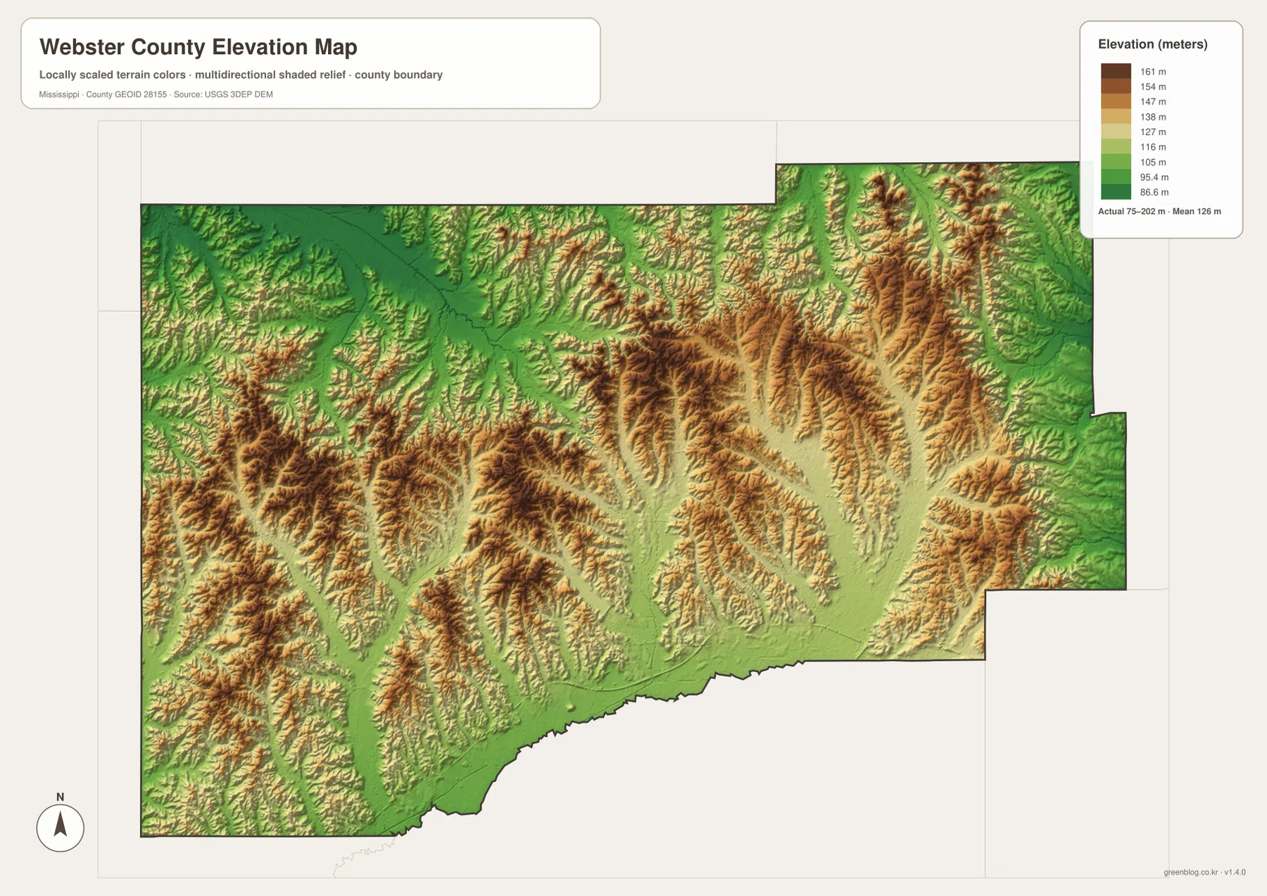
The relationship with the water map is especially clear in the interior. Many of the narrow lower corridors align with the branching creeks, while higher ground separates one small drainage valley from the next. Near the Big Black River, lower terrain becomes easier to follow along the southern side. Roads crossing the interior must work through this repeated ridge-and-valley terrain, which helps explain why a straight-line distance between communities can differ from the distance driven on local roads.
The color scale is designed to reveal local relief within Webster County. It is useful for understanding county-wide terrain and for comparing higher ridges with lower creek corridors, but it is not survey-grade elevation data. Construction, drainage design, property work, or any task requiring an exact elevation at a specific point should use current USGS source data, engineering information, or a professional survey.
Match each map to the information you need
A useful way to read Webster County is to begin with the county map, where the boundary, settlements, and numbered highways remain visible in one view. Once Eupora, Walthall, Mathiston, and Mantee are located, the city-connections map makes their direction and straight-line spacing easier to compare. The water map then adds the creek system that is mostly hidden behind road labels, and the elevation map explains how those channels fit into the county’s repeated ridges and valleys.
- Road and county orientation: use the county map for Eupora, Walthall, Mathiston, Mantee, US 82, MS 9, MS 15, and the county outline.
- Community direction and spacing: use the city map when comparing the highlighted places from Eupora.
- Rivers, creeks, and small lakes: use the water map for the Big Black River, Sabougla Creek, Little Black Creek, Whites Creek, Spring Creek, and the named lakes.
- Relief and valley position: use the elevation map to compare low creek corridors with surrounding ridges across the approximately 75–202 meter range.
The on-page WebP images are convenient for quick viewing, but the downloadable JPG files are better suited to printing, enlarging, or placing in another document. The ZIP includes the high-resolution A3 county map, city-connections map, water map, and elevation map together. That makes it practical to keep the whole set and choose the most useful image later rather than saving each preview individually.
Frequently Asked Questions
Why is Eupora more noticeable on the map if Walthall is the county seat?
Walthall is the county seat, but Eupora is the larger community and lies directly on US 82, the county’s clearest east-west road reference. That makes Eupora more visually prominent on a general road map. Use Walthall for county-government destinations and Eupora when orienting yourself to the southern highway corridor.
Which creeks are useful to follow besides the Big Black River?
Sabougla Creek, Little Black Creek, Whites Creek, and Spring Creek are the clearest named interior channels on the water map. Following them shows how many narrow valleys drain toward lower ground. Dorroh Lake, Savannah Lake, and Whites Creek Lake are useful local landmarks, but the county-wide water pattern is defined more by branching creeks than by large open-water areas.
Can the 75–202 meter elevation range be used for a specific property or construction site?
No. The range describes the county-wide elevation represented on this map and helps show relative ridges and valleys. An exact site elevation for surveying, construction, drainage design, or property work should come from current source data or a professional survey rather than this generalized county map.
Sources and reference data
The maps are simplified for readable web and print use. Population and area figures, roads, hydrography, elevation, and county information can be checked against the official sources below when a newer or more detailed dataset is needed.
- U.S. Census Bureau QuickFacts – Webster County, Mississippi
- U.S. Census Bureau Gazetteer Files
- Mississippi Department of Transportation official highway map
- USGS National Hydrography
- USGS 3D Elevation Program
- Webster County, Mississippi official website
Map File Information
The ZIP contains high-resolution A3 JPG versions of the Webster County boundary map, city-connections map, water map, and elevation map for printing, presentations, classroom use, and local reference work.
- Included Files: county map, city map, water map, and elevation map
- File Type: JPG
Related Maps
Green Map creates custom-edited map images using open geographic data sources such as geoBoundaries, Natural Earth, OpenStreetMap, and government open data. These maps are edited visual materials, not raw data files, and are provided for education, documents, presentations, and graphic reference.