Osceola County in northwestern Iowa is a compact county centered on Sibley, with Ocheyedan, Ashton, Melvin, and Harris spread around it. The general map shows numbered routes 60, 9, 59, 313, and 52, while the water map highlights Ocheyedan River, Little Ocheyedan River, Little Rock River, Otter Creek, and several smaller drainage features. The elevation sheet shows a clear contrast between higher north-central ground and lower river valleys to the southeast and west. High-resolution JPG versions of the supplied maps are available in a ZIP near the end of the page. High-resolution map files are available for download in the section below.
Sibley is the easiest place to use as a starting point. Ocheyedan lies to the east, Harris farther northeast, Ashton to the southwest, and Melvin appears on the city-connections map in the south. The relief map shows the highest terrain concentrated across the north-central and west-central interior, while the Ocheyedan River system cuts a broad lower corridor toward the southeast.
Table of Contents
Road references place Sibley between Ashton and Ocheyedan
The general county map makes Sibley the clearest western-central landmark. Route 60 passes just south of the city and continues toward Ashton. Route 9 appears near Harris in the northeast, while routes 59 and 313 are labeled close together in the southern-central part of the county. Route 52 is shown near the northern edge.
Ocheyedan provides a strong east-central reference and helps divide the county between Sibley and Harris. The rural road grid is dense and mostly straight, but the waterways bend independently through the fields. Learning the town and route positions first makes the later water and elevation maps much easier to read.
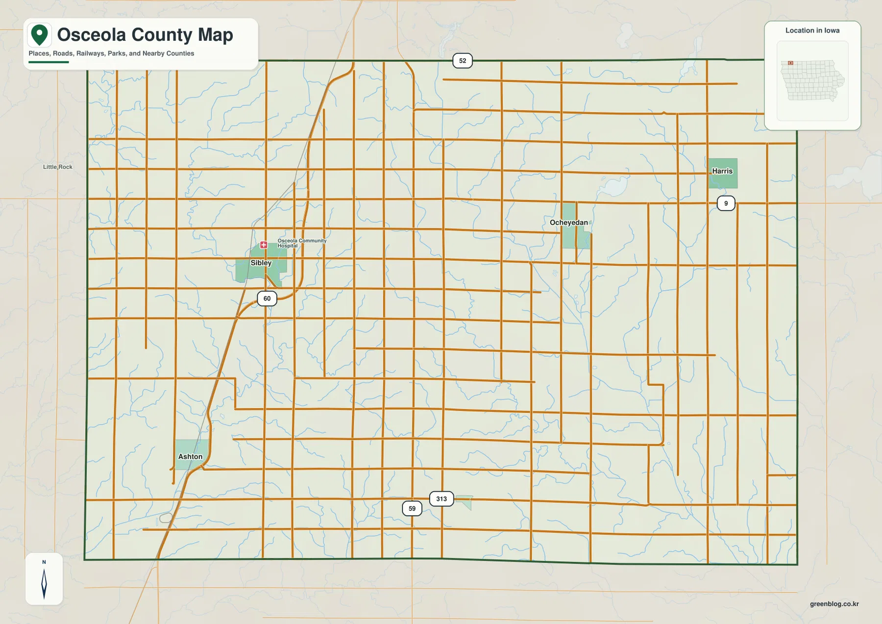
Osceola Community Hospital is also labeled in Sibley and provides another fixed landmark near the county’s main population center. This county map is intended for geographic orientation rather than live navigation. Current road construction, closures, and turn-by-turn routing should be checked with an up-to-date transportation source.
Sibley is the hub for four straight-line city connections
The city-connections map uses Sibley as the hub and links it to Ocheyedan, Ashton, Melvin, and Harris. The mapped population values are 2,803 for Sibley, 511 for Ocheyedan, 461 for Ashton, 230 for Melvin, and 222 for Harris. Those labels make the relative scale of the five highlighted communities easy to compare.
The map gives straight-line distances rather than driving distances. Ocheyedan is about 10 miles from Sibley, Ashton about 7 miles, Melvin about 11 miles, and Harris about 16 miles. Ashton is the closest of the four highlighted connections, while Harris is the farthest and sits on the northeastern side.
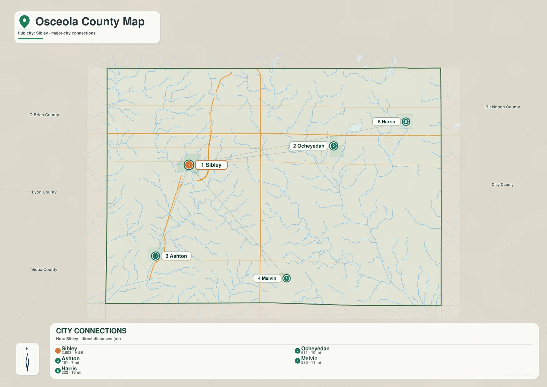
The connection map is especially useful when paired with relief. Sibley and Ashton sit nearer lower western terrain, while Ocheyedan and Harris are closer to the Ocheyedan River drainage and more varied eastern uplands. Melvin lies along the southern side where the central high ground grades toward lower valleys.
Ocheyedan River forms the main eastern drainage corridor
Ocheyedan River is the dominant named waterway on the eastern half of the terrain-and-water map. It descends from the north-central area toward the southeast and forms a long, clearly defined low corridor. Little Ocheyedan River joins the same drainage farther south, creating another branch through the southeastern interior.
Ocheyedan Creek and Rush Lake Outlet are labeled near the upper part of this system. Rush Lake and Iowa Lake provide standing-water references in the northeastern quarter. Judicial Ditch No 64, Dry Run, and Dugout Creek identify additional lower routes that break up the eastern uplands.
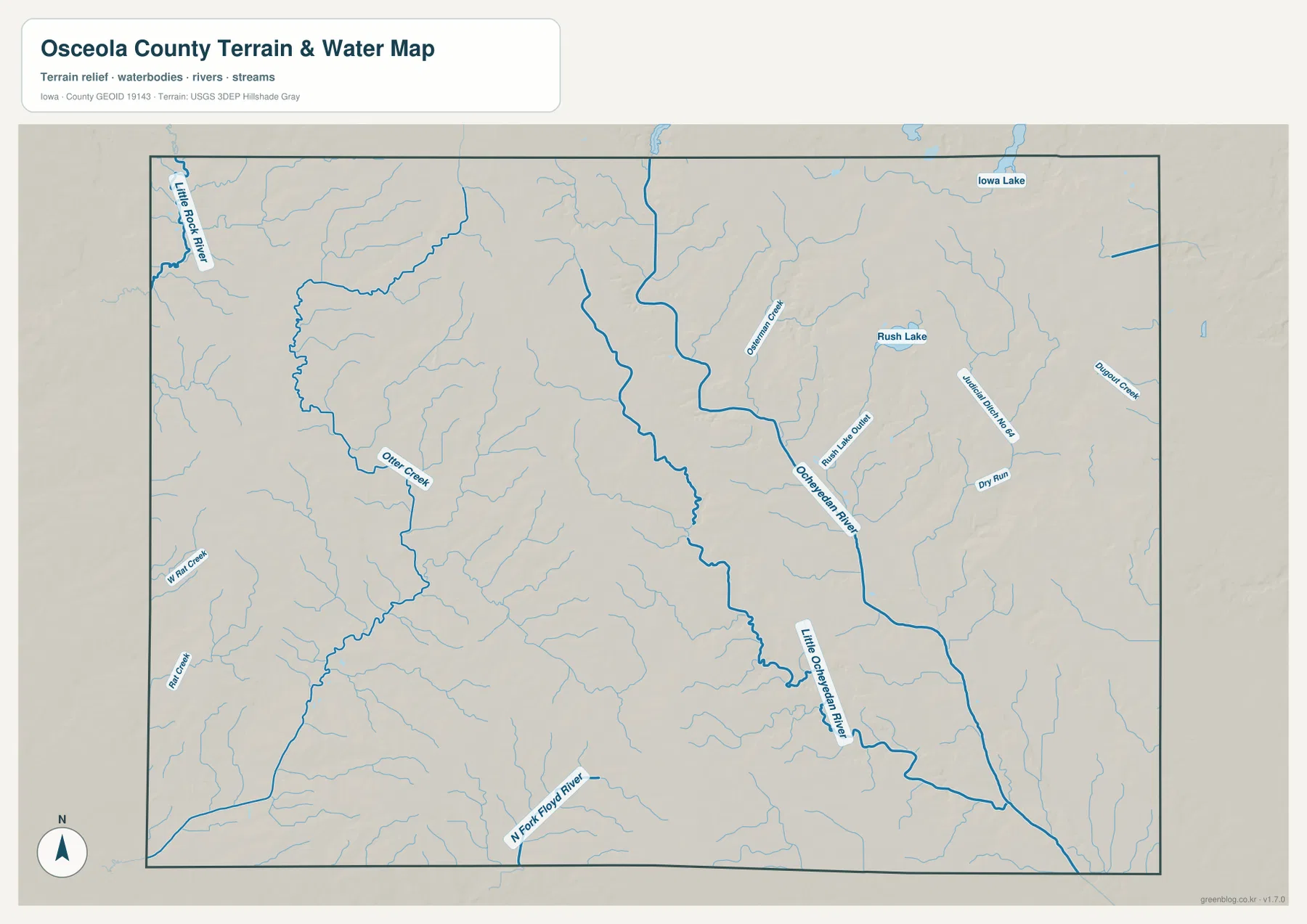
This map is intended for geographic reference rather than flood forecasting, navigation, legal water boundaries, or current water-level reporting. Its value is in showing how the named rivers, creeks, lakes, and drainage channels fit together across the county.
Little Rock River and Otter Creek mark the western valleys
Little Rock River follows the northwestern edge of the supplied water map, while Otter Creek winds through the western interior. W Flat Creek is labeled farther southwest, and N Fork Floyd River appears near the southern boundary. These waterways provide useful references for the lower terrain west of the county’s central uplands.
The western valleys are generally narrower than the large southeastern Ocheyedan River corridor, but they still show up clearly on the elevation map as lower green strips. Around Sibley and Ashton, the contrast between creek valleys and adjacent higher ground is easier to see when the water and elevation sheets are viewed together.
The county therefore has important drainage on both sides of the central high ground. Ocheyedan River and Little Ocheyedan River dominate the east and southeast, while Little Rock River and Otter Creek organize the western side. This two-sided pattern helps explain the shape of the relief map.
Elevation ranges from 423 to 509 meters
The supplied elevation map shows an actual county range of about 423 to 509 meters, with a mean elevation of 466 meters. The darkest brown high ground is concentrated across the north-central and west-central interior. From there, terrain drops toward the western valleys and more strongly toward the Ocheyedan River system in the southeast.
The southeastern drainage corridor is the clearest low feature and appears in dark green. Lower ground also occurs along western waterways, while the northeastern corner contains more moderate terrain between the high central ridge and the deeper river valleys. The mapped difference between the high and low ends is about 86 meters.
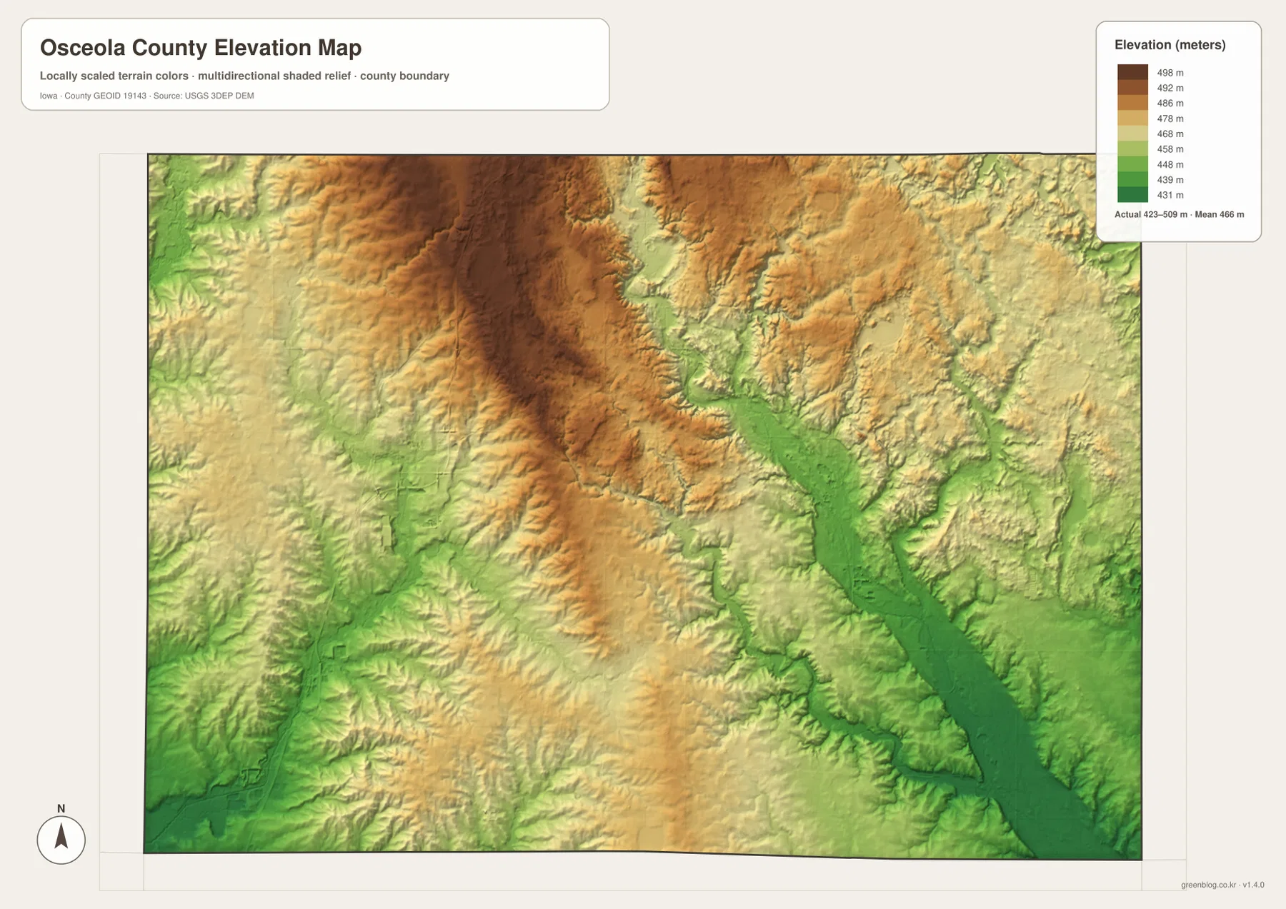
The elevation colors are designed for county-scale comparison rather than survey-grade measurement. Exact parcel elevation, road grade, engineering design, or construction work requires original elevation data or professional surveying. For ordinary map reading, the important feature is the contrast between the central uplands and the surrounding drainage valleys.
Sibley and Ocheyedan provide two useful terrain anchors
Sibley is a practical anchor for the western road network and the lower creek country around Little Rock River and Otter Creek. Ocheyedan provides the opposite reference on the eastern side, where Ocheyedan River and nearby tributaries begin to cut more deeply into the landscape. The high ground between those areas explains why some short city connections cross noticeably different terrain.
Harris works well for the northeastern lakes and smaller drainage features, while Ashton is useful for the southwestern route 60 corridor and lower western relief. Melvin provides a southern reference for the gradual descent from the central uplands. Comparing the same towns across the road, city, water, and elevation maps makes the county’s geography easier to understand.
Choose the Osceola County map that matches the question
Use the general county map when the goal is to locate Sibley, Ocheyedan, Harris, Ashton, and the numbered routes. The city-connections map is better for comparing Sibley with Ocheyedan, Ashton, Melvin, and Harris by straight-line distance and mapped population size.
Use the terrain-and-water map for Ocheyedan River, Little Ocheyedan River, Little Rock River, Otter Creek, Rush Lake, Iowa Lake, and the smaller named creeks and drainage channels. The elevation map adds the 423–509 m range and is the clearest choice for comparing the north-central high ground with lower southeastern and western valleys.
The WebP images in the article are optimized for quick browser viewing. For printing, classroom use, presentations, or closer comparison, the ZIP below contains the county, city-connections, terrain-and-water, and elevation maps as high-resolution JPG files. They are general-reference graphics and do not replace legal boundary records, current transportation data, flood information, or precise survey measurements.
Frequently Asked Questions
What do the Sibley city-connection distances represent?
They are straight-line distances, not driving distances. The supplied map shows about 10 miles to Ocheyedan, 7 miles to Ashton, 11 miles to Melvin, and 16 miles to Harris from Sibley. Road travel may be longer depending on the route.
Where is the clearest low terrain in Osceola County?
The Ocheyedan River and Little Ocheyedan River corridor in the southeast is the strongest low feature on the elevation map. Western valleys along Little Rock River and Otter Creek are also lower than the broad north-central uplands.
How should the 423–509 m elevation range be used?
It is useful for comparing relative relief across the county, and the supplied map gives a mean elevation of 466 meters. Exact site elevations for parcels, roads, or engineering work should be checked against original elevation data or a professional survey.
Map File Information
The ZIP contains four high-resolution JPG maps for Osceola County, Iowa: county, city connections, terrain and water, and elevation.
- Included Files: Use only the versions confirmed in the article and supplied images
- File Type: Use the confirmed download contents
- Intended Use: Printing, education, presentations, and map-based projects
Related Maps
Sources and reference data
The links below provide authoritative U.S. government source data for county boundaries, hydrography, and elevation represented in the supplied map set.
These maps are intended for general geographic reference, learning, printing, and visual comparison. Legal boundaries, ownership, current road conditions, flood risk, water levels, and precise elevations should be checked against the responsible agency’s current records.
Green Map creates custom-edited map images using open geographic data sources such as geoBoundaries, Natural Earth, OpenStreetMap, and government open data.
These maps are edited visual materials, not raw data files, and are provided for education, documents, presentations, and graphic reference.