Butte County is overwhelmingly open country on the supplied 2025 classification. Shrubland accounts for 78.09% of the county, while forest covers 8.27%, agriculture 5.27%, barren ground 3.96%, and grassland 2.83%. The important detail is where those smaller classes interrupt the shrubland. Forest is concentrated in mountain belts, cultivated blocks occupy selected valleys around the Big Lost River setting, and a pale barren zone stands out in the southwest. This Butte County Idaho Land Cover Map is built around those contrasts rather than a simple ranking of percentages.
The page includes four views: current land cover, forest and farmland, impervious surface with developed land, and a 1985–2025 endpoint comparison. The WebP images can be examined with the explanation, and the four original 2480 × 1754-pixel JPGs are grouped in one ZIP below. The set makes it possible to compare a cultivated valley, a forested ridge, a small developed node, and a long-term classification patch without shrinking every layer into one crowded graphic.
Table of Contents
Shrubland forms the countywide base while forest, farms, and barren ground occupy distinct pockets
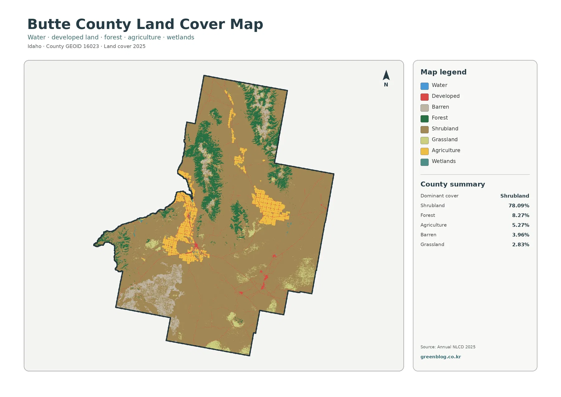
Forest creates the strongest break in that tan background. Although forest is only 8.27% of the county summary, dark-green areas form long irregular belts in the northern and west-central highlands. Additional forest appears along elevated terrain farther east. The pattern is clustered rather than evenly scattered, so the county’s forest percentage understates how dominant trees can appear within specific mountain sections.
Agriculture is smaller at 5.27%, but its yellow blocks are visually prominent because they are concentrated. The largest cultivated areas occur in the central-western portion of the county and extend along a narrow north–south valley. Separate farm blocks appear farther north and east. Their rectangular texture contrasts with the irregular forest edges and broad shrubland, making the working-land footprint easy to distinguish from naturally open vegetation.
Barren ground covers 3.96% and is especially noticeable in the southwest, where pale patches form a much larger cluster than elsewhere. The Bureau of Land Management describes the Craters of the Moon region on central Idaho’s Snake River Plain as a volcanic landscape of lava fields, fissures, craters, and cinder cones. That regional description provides useful context for the sparsely vegetated surfaces in southwestern Butte County, but the image does not contain monument boundaries. The barren class therefore should not be treated as a map of the protected area itself.
Agricultural blocks follow selected valleys instead of spreading across the open plain
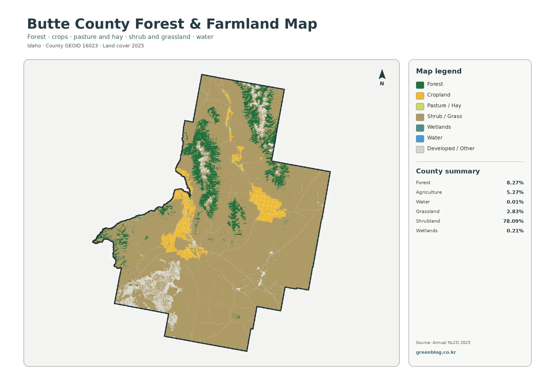
Removing several minor classes makes the cultivated areas much easier to compare with forest. Yellow fields occupy a long central-western corridor and several compact blocks rather than forming a continuous agricultural plain. To the west and north, dark-green forest follows higher terrain; to the east and south, shrub and grass cover dominates. The result is a county where farming is locally important but geographically limited.
Idaho National Laboratory hydrogeologic material describes the Big Lost River leaving the basin-and-range mountains and flowing onto the eastern Snake River Plain at Arco. That regional water setting helps explain why agriculture is concentrated in selected valley bottoms rather than distributed uniformly through Butte County. The land-cover image itself does not label the river or individual farms, so the relationship should be read at the regional scale rather than assigning every yellow cell to a named irrigation district.
Hard surfaces are rare countywide but form recognizable nodes and thin connections
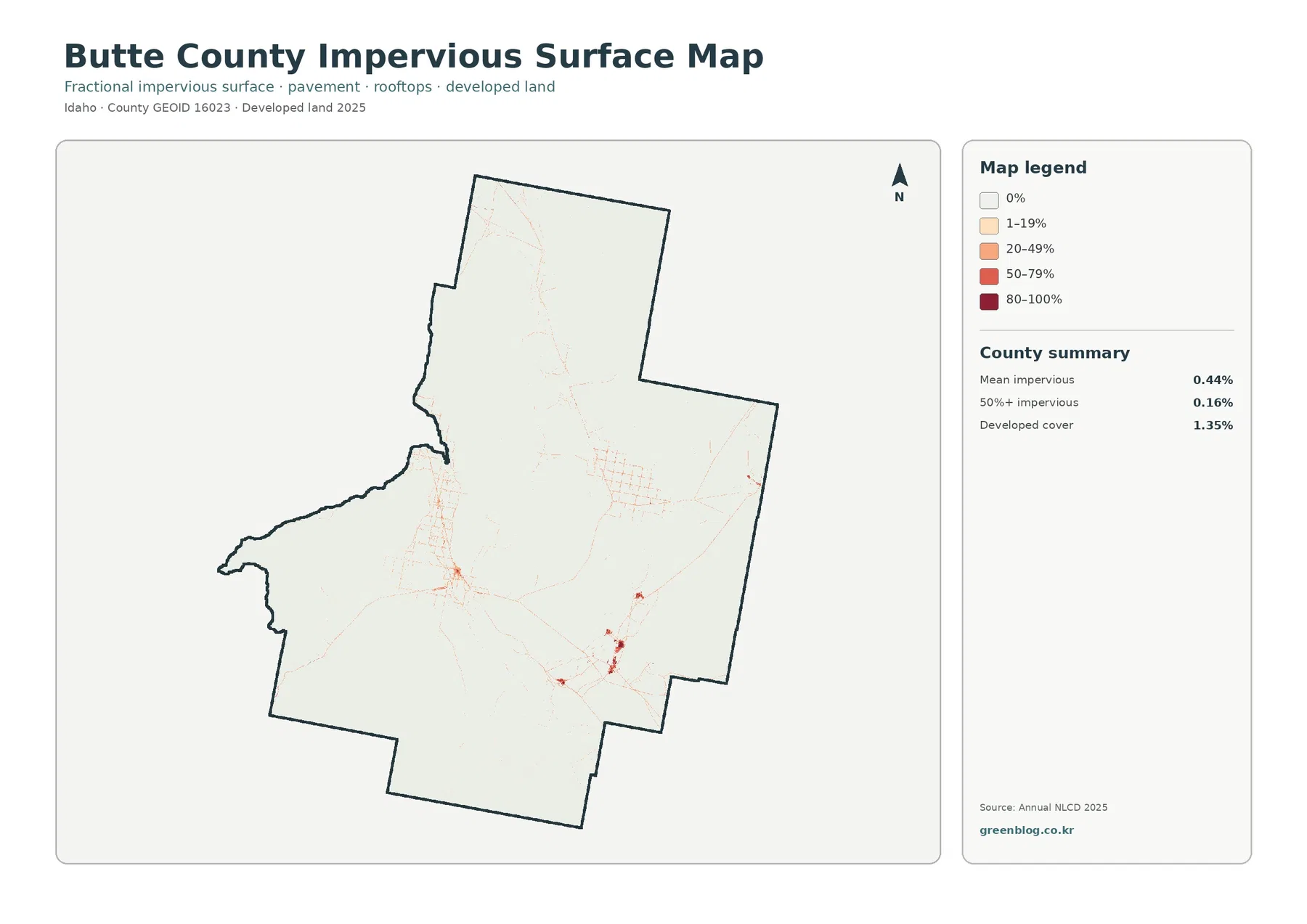
Mean impervious cover is 0.44%, and only 0.16% of the county lies in cells with at least 50% impervious surface. Developed cover is 1.35%. These values fit the visual impression of a county where shrubland, mountain vegetation, agricultural ground, and barren surfaces occupy almost all of the area. Most of the impervious layer is nearly white because rooftops and pavement are sparse outside a few localized concentrations.
The stronger orange and red marks are not evenly distributed. A central-western concentration sits near the major agricultural corridor, while another set of darker nodes appears toward the southeast. Thin traces connect some of these concentrations across otherwise pale ground. The layer identifies where hard surfaces are more abundant, but it does not name towns, facilities, highways, or access routes. Specific transportation and facility questions require dedicated current maps.
Only 7.91% of cells differ between the 1985 and 2025 endpoint classifications
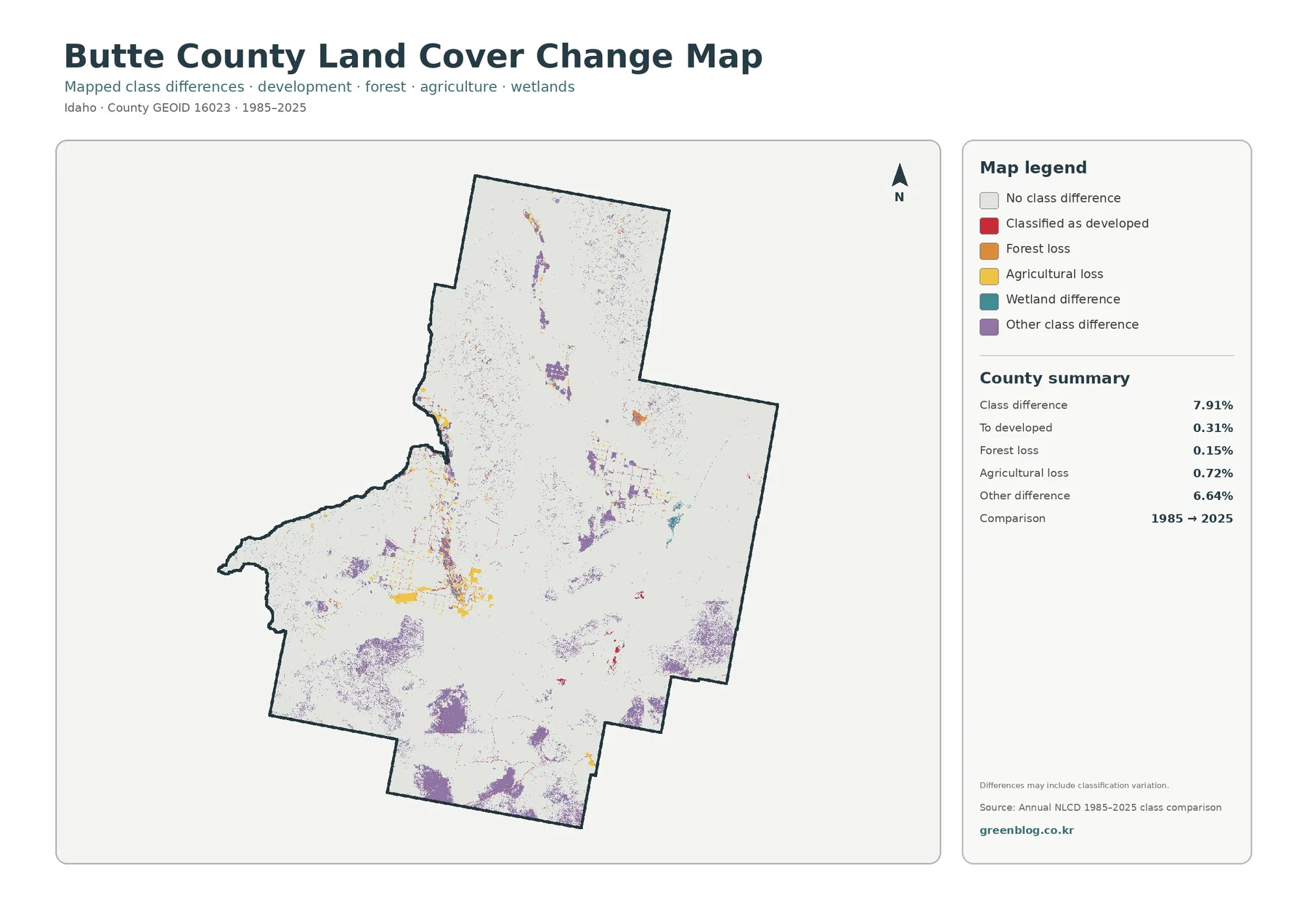
The 1985–2025 comparison marks 7.91% of the county as having a different class at the two endpoints. Only 0.31% is listed as classified to developed, forest loss is 0.15%, and agricultural loss is 0.72%. Other class difference accounts for 6.64%, by far the largest category. The total therefore cannot be described as 7.91% urban growth or 7.91% physical disturbance.
Purple other-difference patches are scattered through southern and central shrubland and appear as additional narrow or compact areas farther north. Yellow agricultural-loss cells are most visible near current agricultural blocks in the central-western corridor. Red developed-difference marks are sparse and localized. The distribution emphasizes that most of Butte County retains the same broad classification at the two endpoints even though selected patches changed class.
The southwest barren zone and Big Lost River setting explain two very different parts of the county
Butte County contains a sharp environmental contrast between cultivated valley ground and sparsely vegetated volcanic or rocky surfaces. The BLM description of Craters of the Moon identifies a broad central Idaho volcanic landscape with lava flows and other young volcanic features. In the land-cover image, pale barren ground is concentrated in the southwest while the strongest agricultural blocks lie farther north and east. Those patterns should be compared as separate surface environments rather than merged under a general label such as “open land.”
The Big Lost River setting provides a second reference. INL studies describe the river crossing from mountain basins onto the eastern Snake River Plain near Arco and continuing into internal sinks. That regional hydrology is relevant to the central valley where agricultural blocks and small developed concentrations appear. The land-cover product, however, is not a hydrology or irrigation map, so river flow paths, diversions, and water rights require specialized sources.
Compare the same location across layers to separate current cover from long-term difference
Start with the 2025 overview when the goal is to explain the county as a whole. It establishes the shrubland majority and identifies the main exceptions: forested mountains, agricultural corridors, barren ground, and small developed areas. The forest-and-farmland version then removes several minor classes so the cultivated blocks and forest belts can be compared more directly.
Thirty-meter raster cells set a clear limit on parcel-level interpretation
The download contains four original JPG files
The ZIP includes one original JPG for 2025 land cover, forest and farmland, impervious surface and developed land, and 1985–2025 land-cover change. The package keeps the shrubland majority, cultivated valley blocks, mountain forest, barren surfaces, hard-surface concentrations, and endpoint differences available as separate full-size images.
Frequently Asked Questions
What is the largest land-cover class in Butte County?
Shrubland is the largest class at 78.09% in the supplied 2025 summary. Forest is 8.27%, agriculture 5.27%, barren ground 3.96%, and grassland 2.83%. The shrubland majority is visible across nearly every major part of the county.
Why is developed cover visible when mean impervious cover is only 0.44%?
Hard surfaces are concentrated in a few small nodes rather than spread across the county. Developed cover is 1.35%, and that class can include permeable lawns, trees, or soil around buildings, while the impervious percentage isolates rooftops, pavement, and other hard surfaces.
Does the 7.91% class difference mean that much of the county was developed?
No. Only 0.31% is listed as classified to developed. The total also includes 0.15% forest loss, 0.72% agricultural loss, and 6.64% other class difference, so the endpoint comparison includes several non-development class changes.
Sources and Reference Data
- MRLC Annual NLCD CONUS Collection 1.2 – official MRLC release confirming the 2025 product year and 1985–2025 coverage for the conterminous United States
- USGS Annual NLCD Land Cover Classification – class definitions for shrubland, forest, agriculture, barren ground, developed land, and related categories
- BLM Craters of the Moon National Monument – official regional description of central Idaho lava fields and volcanic surfaces
- Idaho National Laboratory Hydrogeologic Study – regional context for Arco, the Big Lost River, and the eastern Snake River Plain
Map File Information
The ZIP contains four original JPGs for comparing Butte County's 78.09% shrubland, agricultural corridors, mountain forest, barren ground, limited hard surfaces, and 1985–2025 endpoint differences.
- Included Files: Four JPG land-cover maps described on this page
- File Type: ZIP containing four JPG maps
- Intended Use: Printing, education, presentations, and map-based projects
Related Maps
Green Map creates custom-edited map images using open geographic data sources such as geoBoundaries, Natural Earth, OpenStreetMap, and government open data. These maps are edited visual materials, not raw data files, and are provided for education, documents, presentations, and graphic reference.