The high-resolution Claiborne County Tennessee Map files are available as an A3 JPG ZIP in the download box below. The set separates county roads and places, city connections, waterways, and elevation so you can use the layer that matches the question instead of squeezing every detail onto one image. Claiborne County sits at Tennessee’s northeastern edge, where the Cumberland Gap area, Tazewell and New Tazewell, and the river country toward the southwest occupy noticeably different parts of the county.
A useful way to orient yourself is to start at the northern border rather than at the county seat. Cumberland Gap and Harrogate sit close together near the top of the county, while Tazewell and New Tazewell lie farther south and east. The physical maps then add the reason this arrangement matters: ridges rise sharply on the northwest and southeast sides, while Powell River, Clinch River, and numerous creeks occupy lower corridors between them. The elevation surface ranges from about 305 to 952 meters, with a mean near 452 meters.
Table of Contents
The northern border holds a different cluster from the Tazewell area
On the general county map, Cumberland Gap occupies a small projection along the northern edge. Harrogate lies immediately below it, and the main road network fans southward from that area. Tazewell and New Tazewell form another close pair in the southeastern half of the county. This creates a clear two-cluster pattern: one group is tied to the gap and state-line approaches, while the other is tied to the county seat and the interior road network.
The road labels reinforce that layout. Route 63 descends from the Harrogate area toward Tazewell, while US 25E appears near Tazewell and continues toward the southern side. Routes 190, 90, and 132 are visible in the west and northwest; 345, 33, and 32 appear toward the east and southeast. The map is most useful when those numbers are read as approaches to valleys and border crossings rather than as an isolated road list.
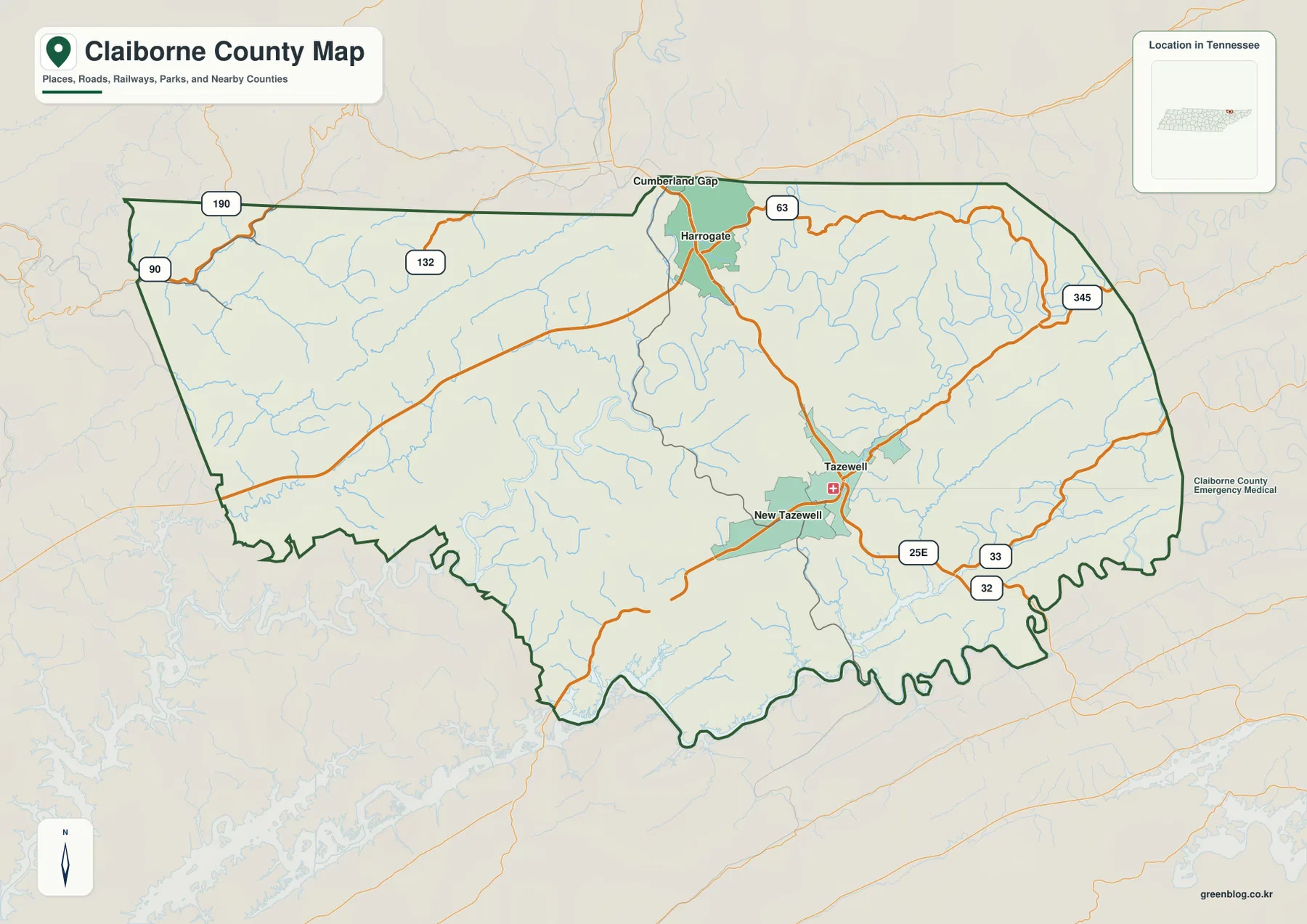
Because Claiborne County touches more than one state, edge labels deserve extra attention. Tennessee neighbors include Campbell, Union, Grainger, and Hancock counties, while Kentucky and Virginia lie immediately beyond parts of the northern and northeastern boundary. A road or community that appears close to the outline may continue into another jurisdiction, so the dark county line should be checked before assigning a feature to Claiborne County.
Harrogate makes a practical reference point for the four highlighted communities
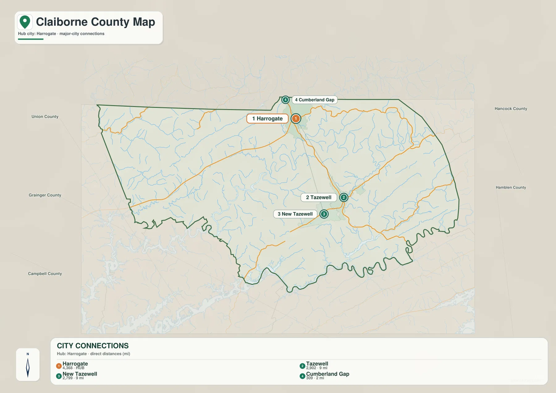
The city-connections map intentionally strips away many secondary labels. Harrogate is the hub, Cumberland Gap is the closest highlighted place to its north, and Tazewell plus New Tazewell form the southern pair. That simplified view is helpful because the more detailed county map can make the short Cumberland Gap–Harrogate relationship easy to overlook among roads, streams, and terrain.
The map gives straight-line reference distances of roughly 2 miles from Harrogate to Cumberland Gap and about 9 miles to both Tazewell and New Tazewell. Those numbers are not driving distances. In a ridge-and-valley landscape, a short geometric separation can still require a longer road approach, so the distance graphic works best as a location comparison rather than a travel-time guide.
Countywide figures provide scale without replacing the map. The 2020 census counted 32,043 residents, and the Census material included with the package gives a July 2025 estimate of 33,229. The 2025 Gazetteer lists about 434.6 square miles of land and 6.9 square miles of water. These are county totals; they do not say that people are distributed evenly between the northern gap communities, Tazewell, rural valleys, or higher ridge country.
Powell River and Clinch River anchor the southwest water network
The terrain-and-water map is dense with named streams, but the larger pattern is easy to follow once Powell River is found. It bends across the southwestern part of the county, with Davis Creek entering from the interior. Clinch River appears farther south. In the northwest, Greer Fork and Straight Creek descend through narrow terrain, while Old Town Creek, Tackett Creek, and Big Creek occupy the north-central part of the map.
The southeastern side has its own drainage pattern. Little Sycamore Creek and Big Sycamore Creek run along elongated valleys, and smaller channels branch toward them. Fern Lake and Templin Pond are labeled in the north-central area, while Miracle Pond and Greer Lake sit farther south. The combination of many small creeks and a few larger river corridors explains why the county’s water geography is better understood as a network than as a single dominant lake feature.
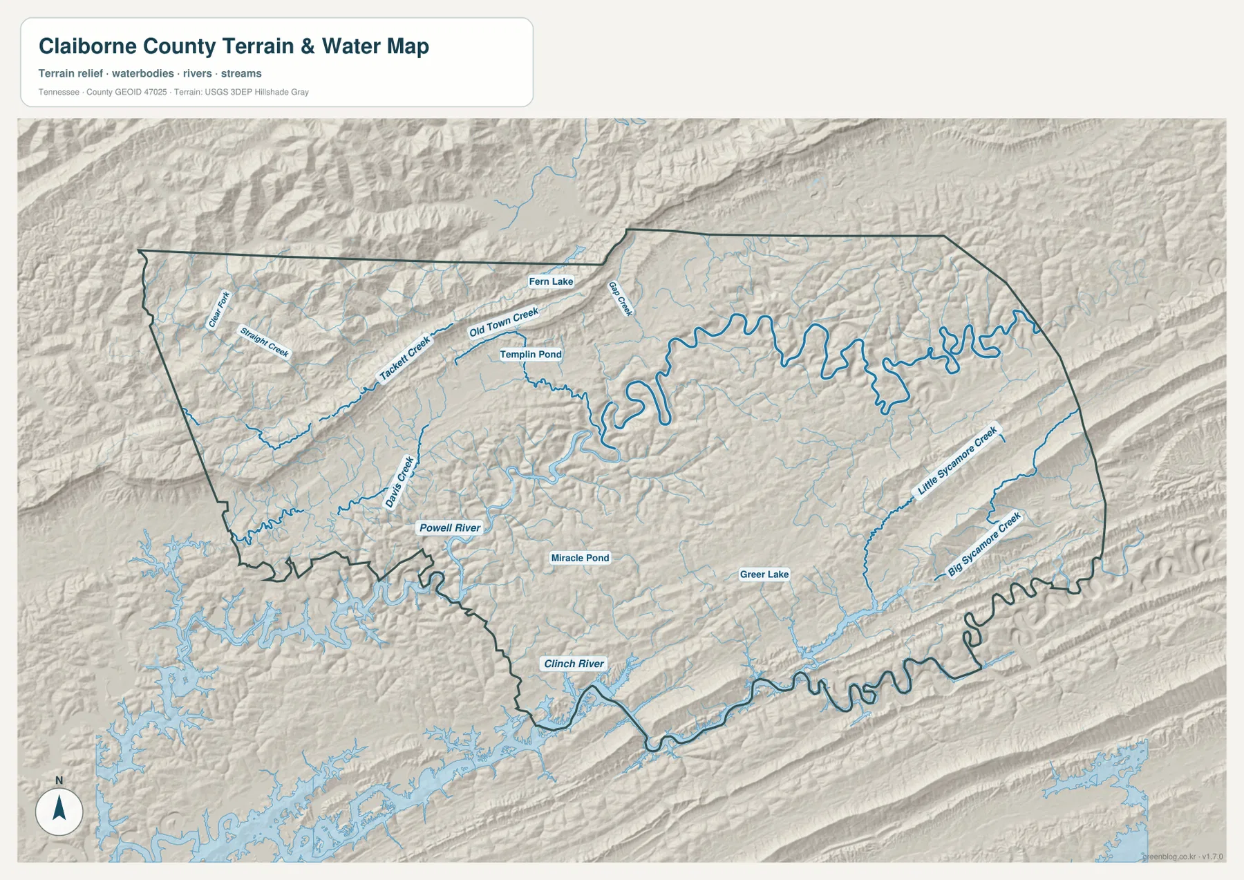
This is an orientation map of water features, not a flood-depth, water-quality, or navigation chart. Reservoir shorelines and stream conditions can change, and the map does not indicate current boat ramps, bridge restrictions, or access rules. Its strength is showing which valleys carry water and where those valleys sit in relation to roads and the county boundary.
A 305–952 m elevation range separates the ridge belts from the interior lows
The elevation map reports an actual range of about 305 to 952 meters and an average near 452 meters. The highest terrain is concentrated in the rugged northwest and along a pronounced ridge belt on the southeastern side. The center of the county contains more green and yellow-green terrain, showing lower elevations cut by branching valleys rather than one continuous high plateau.
The northwest is especially distinctive because several narrow ridges stack closely together near the border. A second long high belt runs diagonally across the southeast, leaving lower ground between the two. When this surface is compared with the water map, many creeks occupy the green corridors between higher slopes. The same comparison also makes it easier to understand why road lines bend around ridges instead of following direct county-scale straight lines.
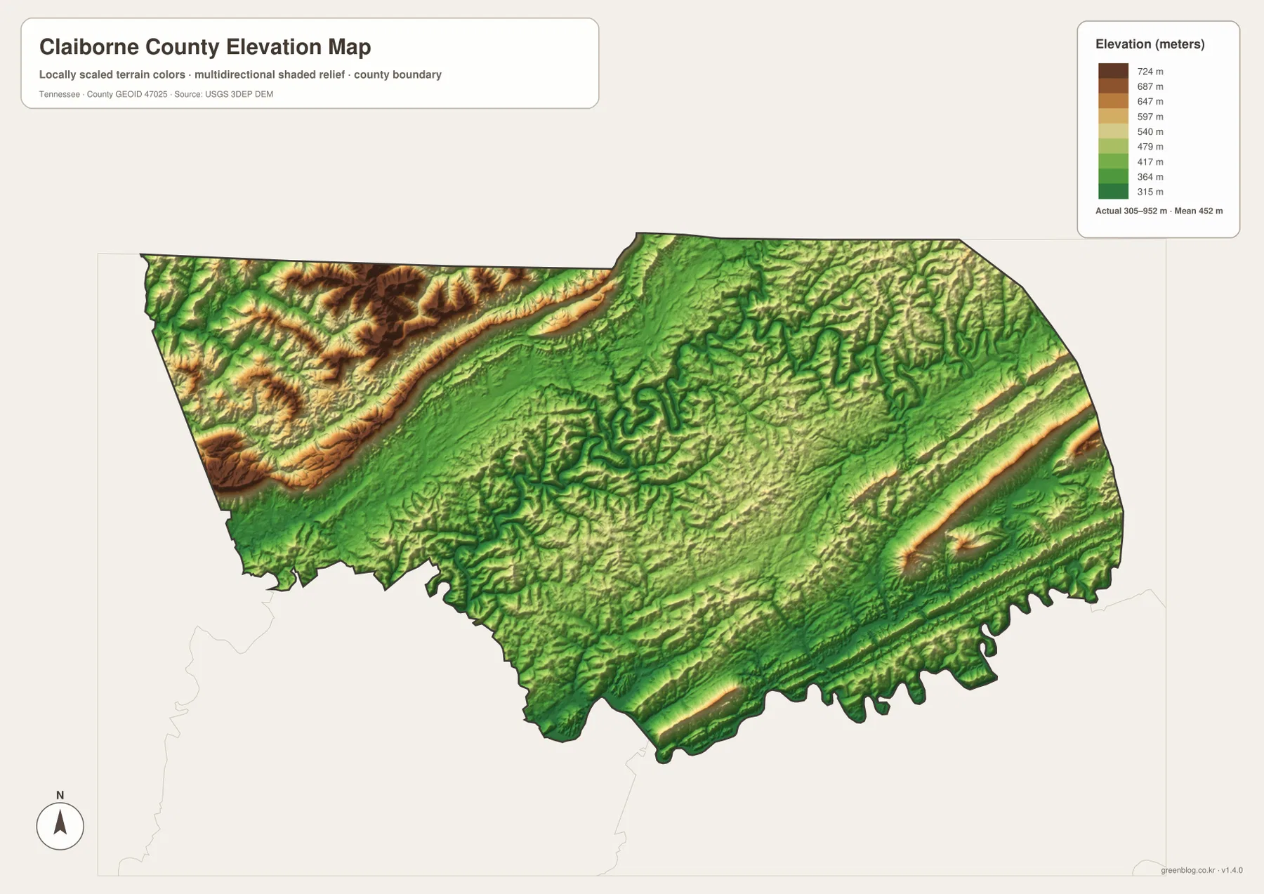
The colors are locally scaled to Claiborne County, so they should be read against the meter legend on this image. A dark high-elevation color here is not automatically equivalent to the same color on another county map. The surface is appropriate for county-level terrain comparison but not for property surveying, construction grades, or exact trail elevations.
Roads make more sense after the ridge and river maps are compared
Tazewell is the county seat, but the route network is not a simple wheel centered on it. Route 63 provides the clearest connection toward Harrogate and the northern gap area, while US 25E and the routes around Tazewell open toward other parts of East Tennessee. On the east, 345, 33, and 32 approach different boundary sectors; on the west, 190, 90, and 132 serve another set of valleys and exits.
For a classroom or planning annotation, a useful sequence is to mark Tazewell as the administrative center, then add Harrogate and Cumberland Gap to establish the northern edge, followed by New Tazewell and the main roads. After that, add Powell River and the major ridge belts. This order keeps the map readable because each new label explains a different part of the county rather than duplicating the same city information.
The county’s position is easier to understand in a three-state setting
Claiborne County was established in 1801, with Tazewell serving as the county seat. Its modern map is unusual in that Tennessee, Kentucky, and Virginia context is visible within a short distance of the northern communities. Bell and Whitley counties lie on the Kentucky side of the broader border area, Lee County lies in Virginia, and Tennessee neighbors include Hancock, Grainger, Union, and Campbell counties.
Cumberland Gap is therefore more than a label at the top of the county image. It marks the part of the landscape where high ridges, state boundaries, and historic travel corridors come together. Harrogate sits immediately south of that setting, while Tazewell lies deeper inside the county. Keeping those roles separate helps avoid treating a well-known park or gap name as if it were the county’s administrative center.
Choose the file by the question you need to answer
Use the county overview when you need communities, route numbers, and the boundary on one page. The city-connections map is cleaner for explaining how Harrogate, Cumberland Gap, Tazewell, and New Tazewell relate to one another. The water map is the better choice for Powell River, Clinch River, and named creeks, while the elevation map is the clearest way to compare the high ridge belts with the lower interior valleys. The downloadable archive keeps these as separate JPG files so you can print or reuse only the map you need.
For printed notes, the county overview works well for route and place labels, while the water and elevation sheets are better kept less crowded so creek names and ridge colors remain legible. If you are building a presentation, showing one map at a time also makes the contrast between the northern gap area, the Tazewell cluster, and the southwest river country much easier to explain.
Frequently Asked Questions
Where is Cumberland Gap on the Claiborne County map?
Cumberland Gap is shown at the narrow northern projection of the county, immediately north of Harrogate. Tazewell and New Tazewell are farther south, so the county and city-connection maps make it easy to compare the border-area cluster with the interior county-seat area.
Which map is best for Powell River and Clinch River?
Use the terrain-and-water map. Powell River is labeled in the southwest and Clinch River farther south, while several named creeks show how smaller valleys feed the larger river system. The map is for location comparison rather than flood forecasting or boating conditions.
What does the elevation map show about Claiborne County?
It shows a countywide range of roughly 305 to 952 meters, with an average near 452 meters. The northwest and southeast contain the most prominent high ridge belts, while lower interior valleys occupy much of the area between them.
Sources and Reference Data
County history and background are available from the Tennessee State Library and Archives Claiborne County fact sheet. The northern gap landscape and park setting can be checked with the National Park Service page for Cumberland Gap National Historical Park.
Boundary and base geography are referenced against U.S. Census Bureau TIGER/Line, while county population and area figures use U.S. Census Bureau QuickFacts and Gazetteer material. Water-feature naming can be cross-checked with USGS National Hydrography, and the elevation reference comes from the USGS 3D Elevation Program.
Map File Information
The ZIP contains the Claiborne County overview, city-connections map, terrain-and-water map, and elevation map as high-resolution A3 JPG files. Use the archive when you need larger originals than the WebP previews shown in the article.
- Included Files: County map, city map, water map, elevation map
- File Type: ZIP containing 4 JPG files
Related Maps
Green Map creates custom-edited map images using open geographic data sources such as geoBoundaries, Natural Earth, OpenStreetMap, and government open data. These maps are edited visual materials, not raw data files, and are provided for education, documents, presentations, and graphic reference.