Bertie County sits in northeastern North Carolina, where a widely scattered group of communities meets a dense network of creeks, swamps, and larger coastal waters. Windsor is the county seat and the easiest place to begin reading the maps, but the county extends far beyond it toward Aulander, Roxobel, Lewiston Woodville, Powellsville, and Colerain. The maps on this page separate those relationships into a county road-and-boundary view, a six-community distribution view, and a water-and-terrain view. High-resolution JPG versions of all three maps are also available together in the downloadable ZIP near the end of the article.
The county does not have one compact urban center that fills most of its area. Windsor lies in the south-central part of the mapped county, while most of the other highlighted communities are farther north or west. That separation is important because a Windsor-only description would miss the northern arc formed by Aulander, Powellsville, and Colerain, as well as the western references provided by Roxobel and Lewiston Woodville. Looking at those places together makes the shape of Bertie County easier to understand before turning to the waterways.
Water provides the other strong geographic reference. Cashie River is labeled in the southeast, while smaller named waterways and swamps spread across the county. The eastern side opens toward Edenton Bay and Albemarle Sound, and the map also labels features such as Salmon Creek, Hoggard Mill Creek, Cucklemaker Creek, Roquist Creek, Indian Creek, Chinkapin Swamp, Beaverdam Swamp, and Connaritsa Swamp. This is therefore a county where settlement, roads, and drainage need to be read together rather than as separate subjects.
Table of Contents
Windsor stands where several mapped routes come together
The general county map makes Windsor the clearest orientation point because several numbered routes converge around it. Route numbers 11 and 42 appear in the western part of the county, 13 runs north from the Windsor area, 17 continues south, 305 serves the north-central corridor, 308 crosses the southeastern side, and 45 appears near the eastern edge. The map is not meant to replace a turn-by-turn road map, but these route labels are enough to show how different parts of Bertie County connect to the county seat.
Moving north from Windsor, Askewville appears before the map reaches the broader northern tier. Aulander lies near the northwestern side of that tier, Powellsville is farther east, and Colerain sits close to the northeastern edge. To the west, Lewiston Woodville provides a useful middle reference before Kelford and Roxobel near the northwest. Because the communities are separated by substantial open areas, the map does not read like a suburban road network. Instead, it shows small settlements connected by a limited set of main routes across a broad county.
The county outline itself is also worth noticing. Bertie County has an irregular western and southern boundary with repeated bends, projections, and narrow sections. The eastern side changes again where the land meets broad water. Those shapes matter when comparing nearby places because a point that looks close across a blank area may sit on the other side of a boundary or water corridor. For a first pass, it is more useful to follow the county edge and the labeled routes than to estimate travel from straight map distance alone.
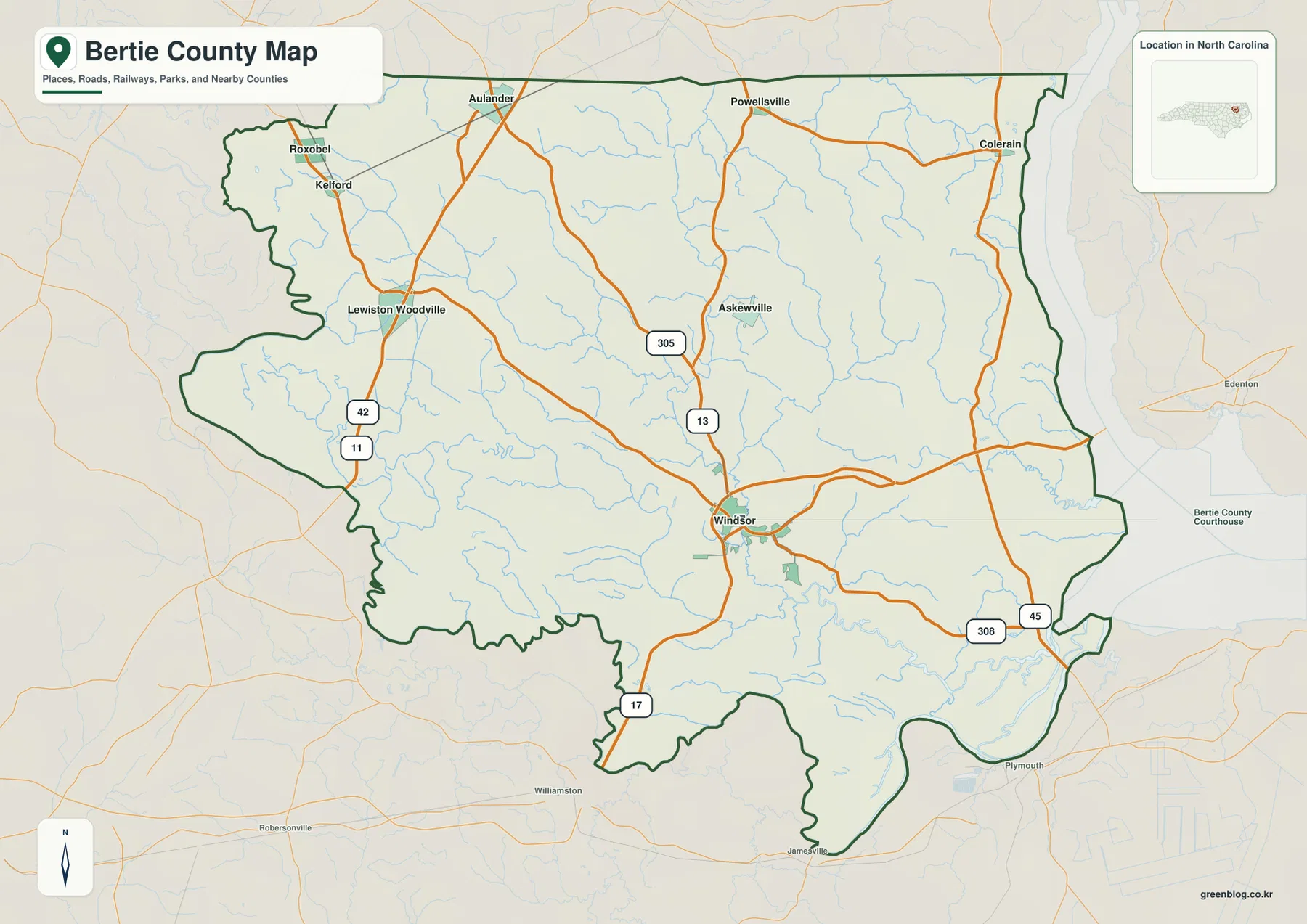
This view works best when the question is about orientation rather than detailed navigation. It can show whether Colerain is generally east or northeast of Windsor, how Lewiston Woodville relates to the western side, where Aulander and Powellsville sit near the north, and which labeled routes provide the broad connections between those areas. It also gives enough surrounding context to see that Bertie County is part of a larger northeastern North Carolina landscape rather than an isolated shape on the page.
Six highlighted communities form a northern arc around Windsor
The settlement-distribution map strips away much of the extra detail and emphasizes six named places: Windsor, Aulander, Lewiston Woodville, Roxobel, Powellsville, and Colerain. Windsor is marked as the leading place in the index and appears well south of most of the other highlighted communities. That single contrast tells an important story about the county. The administrative center is not positioned in the middle of a tight cluster; instead, it sits apart from a group of smaller northern and western communities.
Roxobel occupies the northwest, while Aulander is east of it along the northern side. Lewiston Woodville is farther south and west, giving the western half of the county a second reference point. Powellsville sits in the north-central to northeastern part of the map, and Colerain is closest to the eastern water side. These locations create a loose arc across the upper half of Bertie County. Windsor, by contrast, lies below that arc and closer to the network of waterways that becomes denser toward the south and east.
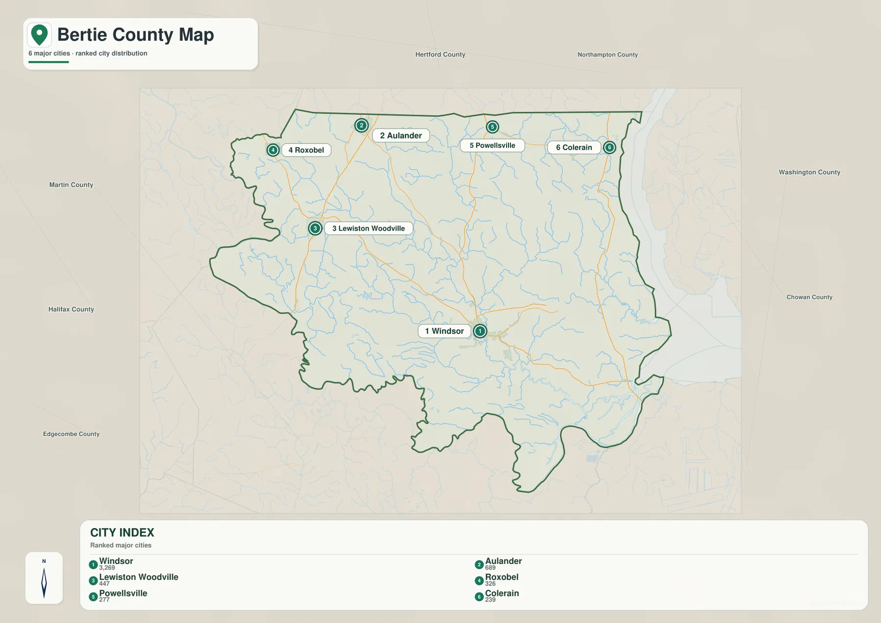
The ranking shown on the map is useful as a visual ordering device, but the most valuable information is still geographic placement. Windsor is labeled first, Aulander second, and Lewiston Woodville, Roxobel, Powellsville, and Colerain follow. The map does not need the reader to memorize those ranks. What matters is that the six points are spread across a large area, and most are not close enough to blend into a single continuous urban zone. That makes the map useful for explaining the county’s settlement pattern without adding unnecessary street-level detail.
Each place also gives a different directional reference. Colerain represents the northeastern side near the larger waters to the east. Lewiston Woodville helps locate the western interior, and Roxobel and Aulander divide the northwest into more than one recognizable point. Powellsville fills the northern area between Aulander and Colerain, while Windsor anchors the south-central part of the county. A reader can therefore use the six locations as a simple framework when matching schools, roads, historical sites, or other county information to a general part of Bertie County.
Cashie River and the Albemarle waters reveal the county’s drainage pattern
The water-and-terrain map changes the emphasis from roads and settlements to rivers, creeks, swamps, and open water. Cashie River is the most prominent named river on the southeastern side of the county. It is surrounded by many smaller channels, showing that this part of Bertie County is not defined by a single isolated river line. The drainage network is broad and branching, with numerous small waterways feeding through low-lying terrain toward the larger coastal waters to the east.
On the eastern side, Salmon Creek appears close to the broad water edge, and the map labels Edenton Bay, Albemarle Sound, and Swan Bay beyond or along that side. Albemarle Sound is especially useful as a regional reference because it explains why the eastern edge looks so different from the inland western boundary. The map is not a legal shoreline survey, but it clearly shows that eastern Bertie County belongs to a landscape shaped by bays, sound waters, and many small tributaries.
The interior names add another layer of detail. Chinkapin Swamp, Beaverdam Swamp, and Connaritsa Swamp appear in the northern and central parts of the map. Cucklemaker Creek and Hoggard Mill Creek cross the interior, while Indian Creek is shown farther west and Roquist Creek appears in the southwestern to south-central area. These names help explain why so much of the county outline and internal geography looks irregular. Water is not confined to the edge; it runs through the interior in many smaller branches.
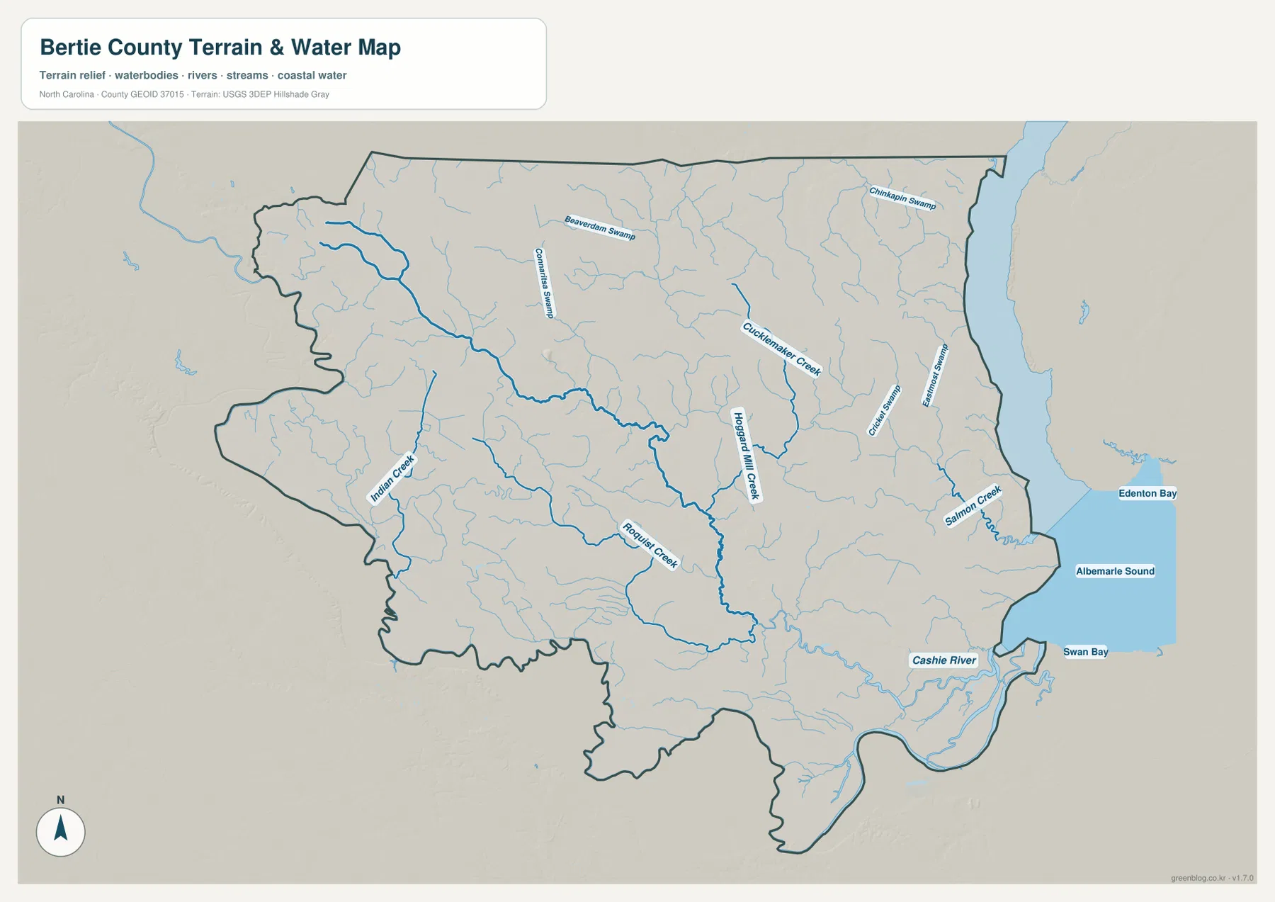
This water view should be treated as a geographic reference rather than a flood, navigation, parcel, or engineering map. It does not provide water depth, flood probability, property ownership, or safe boating routes. Its strength is orientation. It lets a reader place Cashie River relative to the southeastern county, see the larger eastern waters beside Colerain’s part of the county, and understand that the northern interior also contains named swamp and creek systems rather than being uniformly dry land.
Choose the map by the question you are trying to answer
If the goal is to identify county boundaries, route numbers, and the direction from Windsor to another community, start with the general county map. If the main question is how the highlighted settlements are distributed, the six-community map is cleaner because it removes much of the surrounding detail. When the subject is Cashie River, creeks, swamps, or the county’s relationship to Albemarle Sound, the water map gives those features the space they need. Using the views in that order often works well because each map answers a narrower question than the one before it.
For example, a reader comparing Windsor and Colerain can first use the road-and-boundary map to establish direction and route context. The settlement map then makes their separation easy to see without other labels competing for attention. Finally, the water map explains that Colerain lies on the side of the county closest to broad eastern waters, while Windsor is associated more directly with the Cashie River corridor. The same method works in the west: Roxobel and Lewiston Woodville can be located on the first two maps and then compared with Indian Creek and Roquist Creek on the water view.
For printed county summaries, classroom material, local-history notes, or personal map collections, the three images can also be used together. The first establishes the county framework, the second simplifies settlement distribution, and the third explains the waterways that are easy to miss on a road-focused view. They should not be stretched into uses they were not designed for: none of the maps is a parcel survey, address finder, flood insurance map, or turn-by-turn navigation product.
The body images are optimized for web viewing, while the ZIP is intended for readers who want the separate JPG files. Keeping the county name and state in the archive filename also makes it easier to organize this download alongside maps for other North Carolina counties. Check the on-page previews first, choose the view that fits your purpose, and then use the matching JPG from the archive.
Frequently Asked Questions
Which map is best for comparing Windsor and Aulander?
The six-community distribution map is the quickest choice because Windsor is clearly marked in the south-central part of the county while Aulander is near the northern side. If you also need route context or nearby places such as Askewville and Powellsville, follow it with the general county map.
What should I look for when reading Cashie River and the Albemarle side of the county?
Start with Cashie River in the southeast and then move east toward Salmon Creek, Edenton Bay, Albemarle Sound, and Swan Bay. After that, look back into the county for Chinkapin Swamp, Beaverdam Swamp, Cucklemaker Creek, Hoggard Mill Creek, Indian Creek, and Roquist Creek. Together they show how widespread the drainage network is.
What files are included in the Bertie County download ZIP?
The ZIP contains three high-resolution JPG files corresponding to the maps shown in the article: the county boundary-and-road map, the six-community distribution map, and the terrain-and-water map. The on-page WebP images are previews, so use the JPG archive when you need the separate full-size files.
Map File Information
The ZIP contains A3 high-resolution JPG versions of the Bertie County boundary-and-road map, city distribution map, and terrain-and-water map shown on this page.
- File Type: ZIP archive
Related Maps
Sources and References
These references provide county background and authoritative boundary or hydrography information relevant to the map content.
- NCpedia – Bertie County geography and county information
- U.S. Census Bureau – TIGER/Line boundary and road data
- USGS National Hydrography – U.S. water data
Green Map creates custom-edited map images using open geographic data sources such as geoBoundaries, Natural Earth, OpenStreetMap, and government open data.
These maps are edited visual materials, not raw data files, and are provided for education, documents, presentations, and graphic reference.