Bladen County is easier to understand as a broad county of separated towns, lakes, rivers, and road corridors than as a place organized around one large urban center. The maps on this page show Elizabethtown together with Bladenboro, White Lake, Clarkton, East Arcadia, Dublin, major numbered roads, the county boundary, and a much wider water network than the Cape Fear River alone. The three A3 high-resolution JPG maps used for these views are also available in one ZIP file below, so the page works both as a geographic guide and as a source for printable map files.
Elizabethtown is the county seat and a useful first reference point, but it does not sit in the middle of every feature that matters. Bladenboro lies well to the southwest, Clarkton is close to the southern boundary, Dublin is northwest of Elizabethtown, White Lake is northeast of it, and East Arcadia appears near the southeastern end of the county. The water map adds another layer: Cape Fear River, South River, Black River, several named creeks, and a group of lakes are spread across different parts of the county. Reading those layers separately prevents the map from becoming a simple list of place names and makes the long north-to-southeast shape of Bladen County much easier to follow.
Table of Contents
Roads and settlements radiating beyond Elizabethtown
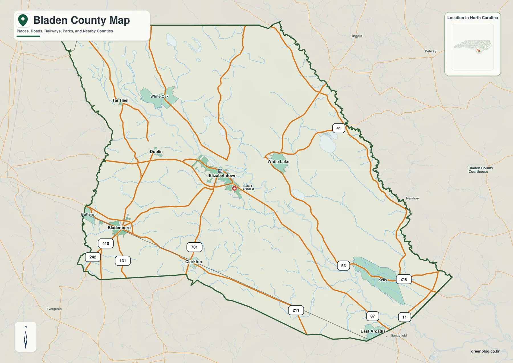
The general county map provides the clearest overview of travel orientation. Elizabethtown appears slightly west of the county’s visual center, with several roads approaching or leaving the area. West of it, Bladenboro forms another prominent settlement reference, while Butters is shown closer to the western edge. Dublin, Tar Heel, and White Oak occupy the northwestern side of the map. Clarkton sits near the south-central boundary, and the eastern half stretches toward White Lake, Kelly, and East Arcadia. Because these places are separated by substantial open areas, a visitor should not assume that an address described as being in Bladen County is necessarily close to Elizabethtown.
The numbered highways help turn that settlement pattern into a practical orientation map. U.S. 701 is shown on the Elizabethtown–Clarkton side of the county. Routes 242, 410, and 131 are visible around the southwestern area near Bladenboro, while 41 appears toward the east and northeast. The southeastern half includes 53, 210, 211, 87, and 11, creating several ways to approach the long lower-right portion of the county. The map is not a substitute for current navigation or road-condition information, but it is useful for seeing which communities share the same general corridor and which ones sit on different sides of the county.
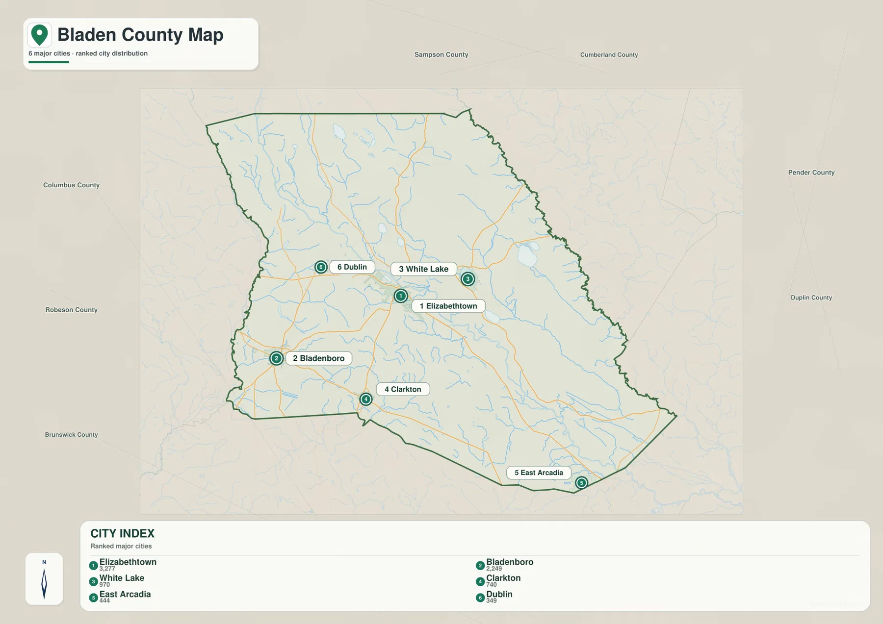
The neighboring-county labels on the city-distribution view are also useful for regional context. Sampson County and Cumberland County are shown to the north, Pender County and Duplin County to the east, Brunswick County to the southwest, and Robeson County and Columbus County to the west. Those labels make Bladen County easier to place within southeastern North Carolina without requiring a full state map. They also explain why roads in the eastern and southeastern parts of the county continue in several different directions rather than funneling through Elizabethtown.
Six labeled places reveal a dispersed county pattern
The city map removes much of the visual competition from the road network and emphasizes six labeled settlements. Its city index lists Elizabethtown at 3,277, Bladenboro at 2,249, White Lake at 970, Clarkton at 740, East Arcadia at 444, and Dublin at 349. Those figures are best read as the values attached to this supplied city index rather than as a replacement for a current census table. What matters most for map reading is the location pattern: the six markers are not clustered together, and each one provides a useful reference for a different part of Bladen County.
Elizabethtown and White Lake are relatively close compared with some of the other pairs, but even they represent different kinds of landmarks. Elizabethtown is the county-seat reference, while White Lake links a named settlement directly to one of the county’s visible lakes. Bladenboro sits well to the southwest and is a better marker for that side of the county than Elizabethtown. Clarkton helps define the southern edge, East Arcadia marks the far southeastern area, and Dublin gives the northwestern side its own labeled point. The result is a county that reads as several separated local areas rather than one continuous built-up zone.
The earlier material preserved in this package also gives a 2025 estimated population of 30,007 and a total area of about 888 square miles. When those summary figures are considered beside the city map, the dispersed arrangement becomes easier to appreciate. A county-wide school project, local-history handout, or regional presentation can therefore benefit from keeping several settlement labels visible instead of enlarging only the county seat. If the task requires individual streets, parcels, buildings, or neighborhood detail, however, a more detailed local map should be used because these files are designed for county-scale orientation.
A water map shaped by more than the Cape Fear River
The terrain-and-water map changes the emphasis completely. Cape Fear River is labeled in the northwestern part of the county, but it is only one of several major water references. South River follows the northeastern side, while Black River appears in the southwest. Harrison Creek, Ellis Creek, Turnbull Creek, and Colly Creek occupy separate corridors through the interior, and Crawley Swamp is labeled farther southwest. Numerous smaller blue channels fill the spaces between the named waterways. This makes Bladen County look less like a county divided by one dominant river and more like a broad low-relief landscape containing many connected and semi-independent water features.
The lakes are just as important for orientation. Little Singletary Lake and Horseshoe Lake appear in the northern interior, with Salters Lake farther south. White Lake is positioned east of the county’s central area and is the lake name most clearly tied to a labeled settlement on the other maps. Bay Tree Lake lies farther east, while Singletary Lake is shown south of White Lake. Because these lakes are distributed across several parts of the county, a map focused only on White Lake would miss much of the supplied water information. For environmental context, recreation planning at a broad scale, or simple geographic study, the full water map gives a more complete picture.
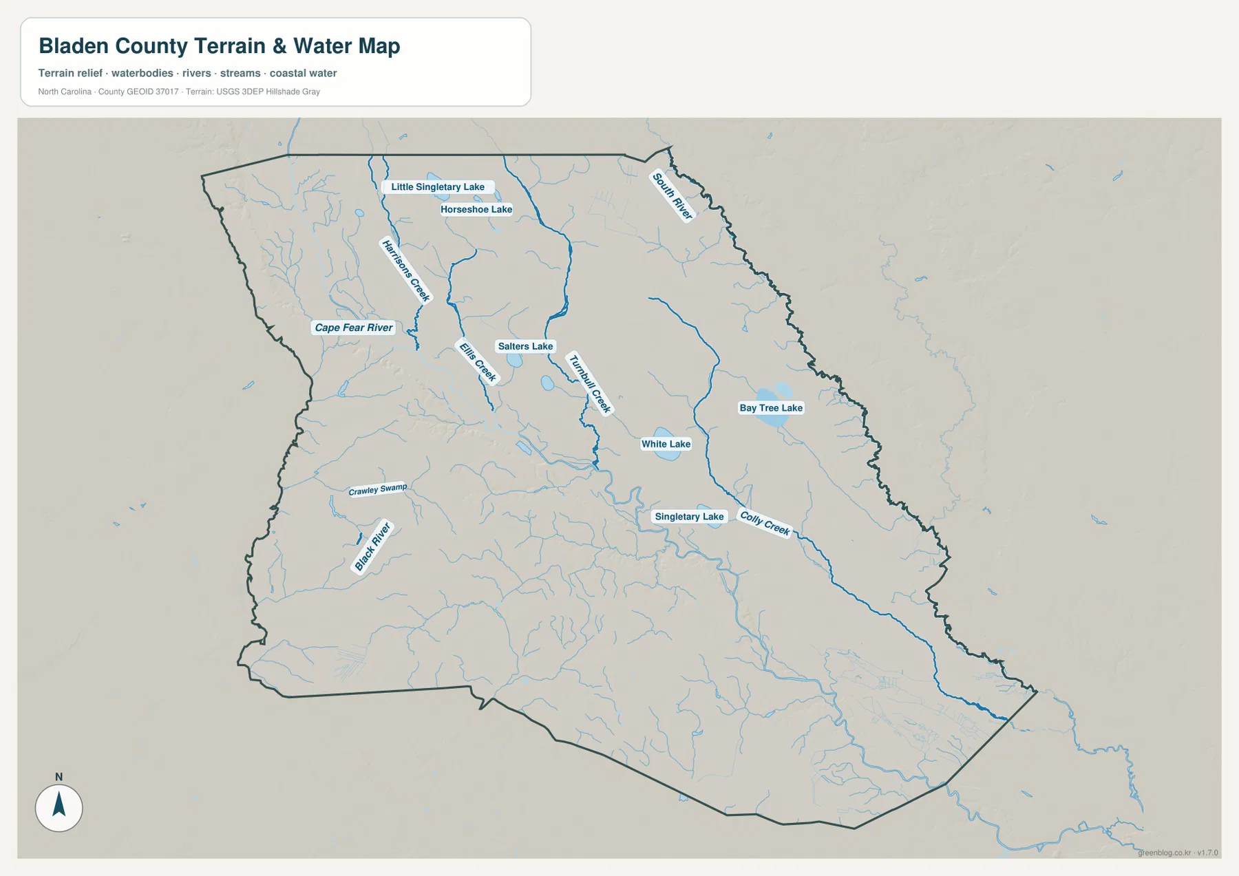
The shaded terrain backdrop helps separate water features from the surrounding surface, but this is not a contour map, flood-hazard map, or parcel-level elevation product. It should not be used to determine whether a particular property floods or to calculate an exact elevation. Its strength is regional comparison: readers can see where major rivers sit relative to the county boundary, where the named lakes are located, and how the many creek lines occupy the interior. The southeastern reach toward East Arcadia is especially useful to compare with the road map because the area contains both long road connections and an extensive network of small watercourses.
Choosing the view that matches the question
Use the general county map first when the question involves roads, the county boundary, or the direction from one community to another. It is the best single view for locating Elizabethtown and then tracing outward toward Bladenboro, White Lake, Clarkton, Kelly, or East Arcadia. The road labels also make it practical for a broad travel overview, especially when the goal is to understand which side of the county a destination occupies rather than to obtain turn-by-turn directions.
Use the city-distribution map when the place names themselves are the main subject. With six ranked markers and fewer competing labels, it is easier to compare the position of Elizabethtown with Bladenboro or to explain why East Arcadia belongs to a very different part of the county from Dublin. The water map is the better choice when rivers, lakes, creeks, or terrain context matter. Its combination of Cape Fear River, South River, Black River, multiple lakes, and smaller waterways makes it especially useful for showing that the county’s natural geography is not centered on the same places as its settlement pattern.
For printing, classroom use, presentations, or close inspection of labels, use the downloadable JPG files rather than relying only on the WebP previews in the article. The previews are optimized for page display, while the ZIP contains three A3 high-resolution JPGs: the county map, the city-distribution map, and the terrain-and-water map. Keeping the files separate also lets you choose a clean settlement view for one project and a more detailed water view for another without placing every layer on the same page.
Frequently Asked Questions
Does White Lake represent the county’s full lake pattern?
No. White Lake is an important and easy-to-find reference because it appears as both a place name and a lake feature, but the supplied water map also labels Singletary Lake, Bay Tree Lake, Little Singletary Lake, Horseshoe Lake, and Salters Lake. For a water-focused view of Bladen County, those lakes should be considered together with Cape Fear River, South River, Black River, and the named creeks.
Which map is best for comparing Elizabethtown and Bladenboro?
The city-distribution map is the fastest option because both places are clearly numbered and the surrounding road detail is reduced. It shows Elizabethtown in the central-western part of the county and Bladenboro farther southwest. If you also need to see the main road connections or compare them with Clarkton, Dublin, and White Lake, follow with the general county map.
Map File Information
Download the Bladen County county map, city-distribution map, and terrain-and-water map as three A3 high-resolution JPG files in one ZIP archive.
- Included Files: Use only the versions confirmed in the article and supplied images
- File Type: Use the confirmed download contents
- Intended Use: Printing, education, presentations, and map-based projects
Related Maps
Sources and references
These references cover Bladen County background and the types of boundary, hydrography, and elevation data used for county-scale mapping. The article itself prioritizes the features visible in the supplied map package and the verified items preserved with the existing post.
- NCpedia – Bladen County geography and county information
- U.S. Census Bureau – TIGER/Line boundary and road data
- USGS – National Hydrography
- USGS – 3D Elevation Program
Green Map creates custom-edited map images using open geographic data sources such as geoBoundaries, Natural Earth, OpenStreetMap, and government open data.
These maps are edited visual materials, not raw data files, and are provided for education, documents, presentations, and graphic reference.