Download the high-resolution Union County JPG maps in one ZIP from the file box below. The package includes the general county, city, terrain-and-water, and elevation views at 2572×3638 pixels each. Liberty sits near the middle-west of the county, West College Corner lies close to the southeastern edge, and Brownsville marks the Whitewater side. The physical maps add East Fork Whitewater River, Whitewater Lake, Brookville Lake, several named creeks, and a steep 226–347 meter relief change between the western valley and the higher eastern interior.
This Union County Indiana map set is easiest to follow from Liberty. Route 44 heads east from town, Route 27 angles southeast toward West College Corner, and Route 101 extends south. Route 9 provides another north–south reference farther east. The road grid looks fairly orderly through the center and east, but the western side becomes more irregular as roads approach the Whitewater valley.
The elevation image shows why the western side feels so different. Dark green low ground follows East Fork Whitewater River and the Whitewater Lake–Brookville Lake corridor, while tan and brown terrain spreads across much of the east and northeast. Silver Creek, Hanna Creek, Indian Creek, and other streams cut narrow lower valleys into the higher interior.
Table of Contents
Liberty connects the county’s eastward and southeast road lines
Liberty is the clearest starting point on the general county map. Route 44 leaves the town toward the east, Route 27 angles toward West College Corner, and Route 101 continues south. Fayette Regional Emergency Medical is labeled near Liberty, giving another visible landmark. Once those three road directions are fixed, the rest of the county becomes much easier to scan.
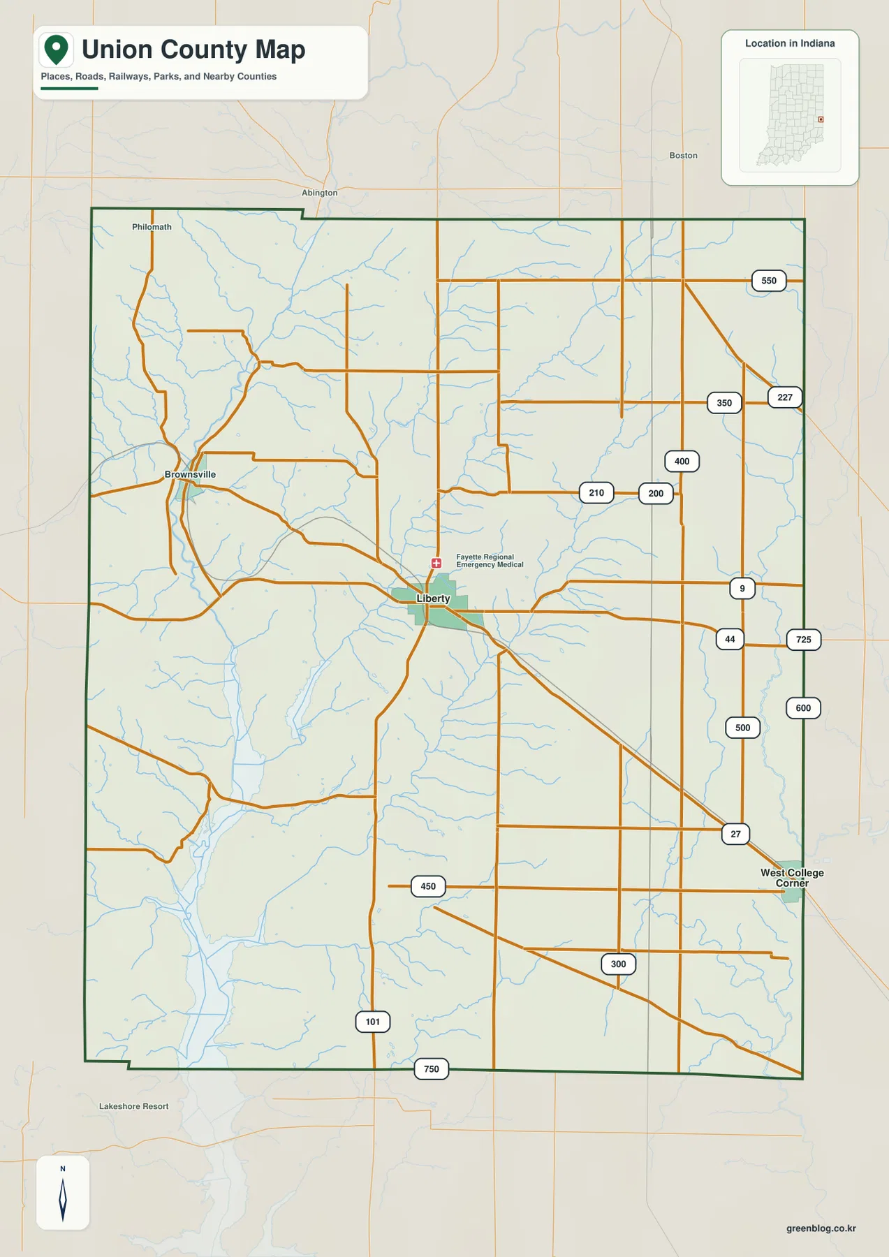
On the eastern side, Route 9 creates a separate north–south line, while roads marked 200, 210, 350, 400, 500, 550, 600, and 725 subdivide the interior. West College Corner sits at the southeastern edge and is easiest to find by following Route 27. The straight road pattern here contrasts with the western Whitewater side.
Brownsville lies much closer to East Fork Whitewater River. Roads bend more often as they approach the valley, and the county edge becomes less visually regular than the eastern grid. This road change matches the physical maps, where the western terrain drops sharply into the river and lake corridor.
The general view is useful for county-scale orientation, named places, and major road directions. Temporary road work, closures, or changing restrictions are not tracked here, so actual travel planning should use a current transportation source.
Liberty and West College Corner mark the county center and eastern edge
The city view simplifies the county to Liberty and West College Corner. Liberty lies slightly west of the center, while West College Corner sits close to the eastern boundary. The large gap between the two makes it clear that the county’s highlighted communities are not clustered in one compact urban area.
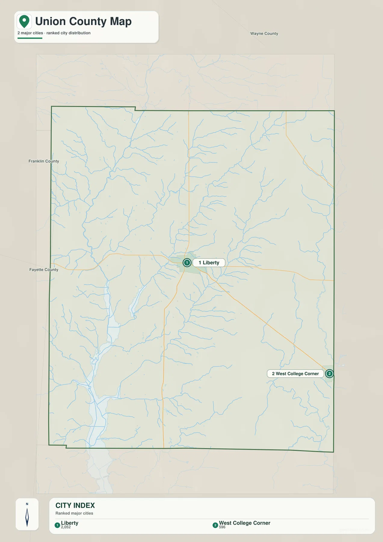
The CITY INDEX also prints numeric values beside the two names, but the supplied graphic does not identify their statistical year or provide a separate source. This page therefore does not present those figures as current official population. A current U.S. Census release should be used when up-to-date population counts are needed.
Wayne County is labeled to the north, Franklin County to the west and southwest, and Fayette County along the western side. Those neighboring labels help place Union County within eastern Indiana and make West College Corner’s edge position easier to understand.
The two-community layout also helps organize the water map. Silver Creek and Richland Creek occupy the area west and northwest of Liberty, while Hanna Creek and Indian Creek become more important across the central and eastern interior. The creeks divide the higher ground into a series of narrow valleys.
East Fork Whitewater River and the reservoir corridor dominate the west
East Fork Whitewater River is the strongest water feature on the terrain-and-water map. It runs through the western side of the county and aligns with the broad low valley that also contains Whitewater Lake and Brookville Lake. The same corridor appears as the darkest green area on the elevation view.
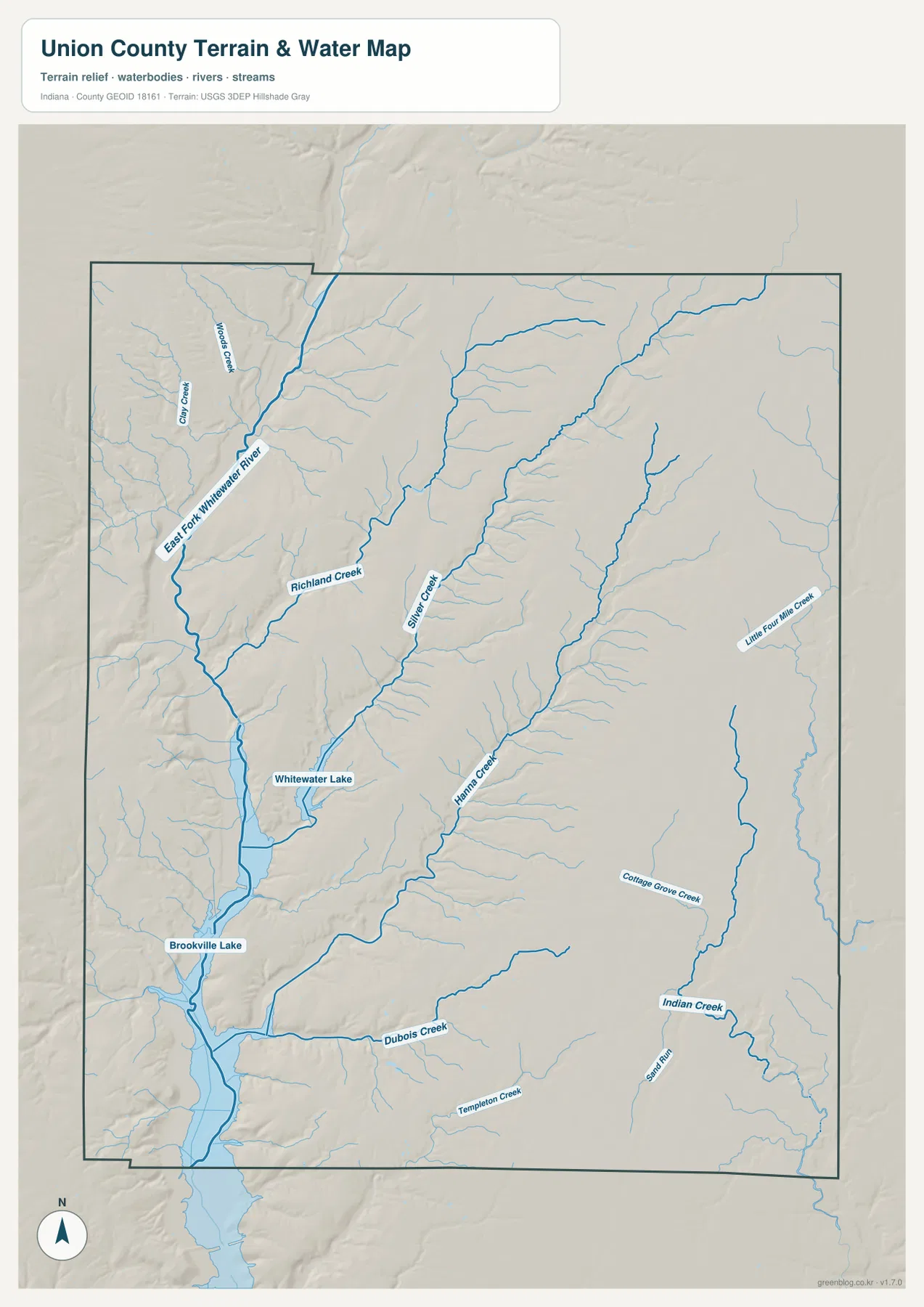
Wood Creek and Owl Creek appear near the northwestern Whitewater side, while Richland Creek extends farther toward the middle of the county. Silver Creek forms a long interior valley that reaches southward through the higher terrain. These tributaries make the western half much more dissected than the road grid suggests.
Hanna Creek, Indian Creek, Dubois Creek, Templeton Creek, College Grove Creek, and Little Four Mile Creek appear across the central, southern, and eastern portions of the map. They occupy separate valleys rather than one single drainage line, so locating them by name is useful for understanding the interior terrain.
This water view is intended to locate rivers, lakes, and named creeks at county scale. It does not define flood limits, parcel boundaries, legal water lines, water depth, or navigation conditions; those questions require current agency data created for those purposes.
The 226–347 meter surface rises sharply from the Whitewater valley to the east
The elevation legend reports an actual Union County range of about 226 to 347 meters and a mean of 299 meters. The deepest green follows the western river-and-lake corridor, while yellow, tan, and brown become increasingly common toward the center, east, and northeast. The county therefore has a much stronger relief contrast than the road map alone suggests.
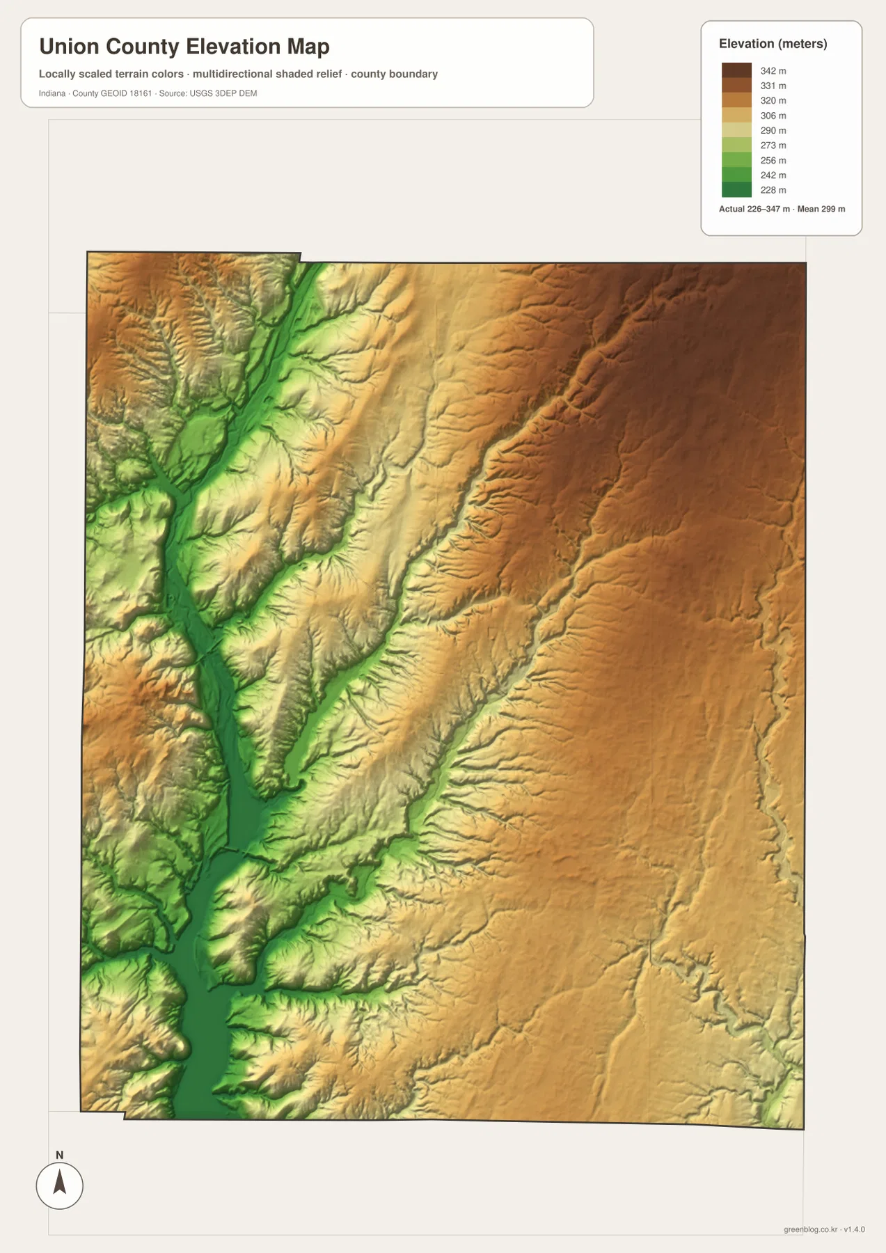
The eastern uplands are not flat. Silver Creek, Hanna Creek, Indian Creek, and smaller tributaries appear as green or light-green incisions through the higher brown surface. Short ridges repeat between those valleys, giving the interior a rolling and locally steep appearance.
Near Whitewater Lake and Brookville Lake, the change is even stronger because the valley floor sits immediately beside higher ridges. Moving east from the Whitewater corridor brings a rapid increase in elevation before the terrain opens into the broader high interior.
The relief image is intended for broad countywide comparison rather than surveyed point elevations. For an exact height at a building, road location, field, or parcel corner, consult source elevation data or a professional survey.
Keep Liberty fixed while comparing roads, streams, and elevation
For basic orientation, start with Liberty and Routes 44, 27, and 101. The city view is cleaner when the only question is how Liberty and West College Corner are positioned relative to one another. Once those locations are familiar, Brownsville and the eastern road grid become easier to place.
For the physical landscape, find East Fork Whitewater River, Whitewater Lake, Silver Creek, and Hanna Creek on the water map. Then open the elevation image at the same locations. The western valley remains low and green, while the eastern interior rises sharply and is cut by narrow creek valleys.
The page uses smaller WebP previews for quick browser viewing. The ZIP contains the full-resolution JPG originals for the general county, city, terrain-and-water, and elevation views, each measuring 2572 by 3638 pixels. These originals are better suited to A3 output and close inspection of road or creek labels.
A simple comparison routine is to keep Liberty fixed, locate the main numbered roads, trace the Whitewater corridor and interior creeks, and finish by comparing the western green valley with the eastern tan-brown uplands.
Frequently Asked Questions
What is the easiest place to use as a starting point on the Union County maps?
Liberty is the most useful starting point because Routes 44, 27, and 101 are easy to locate nearby. From Liberty, West College Corner lies southeast and Brownsville lies west toward the Whitewater valley.
Are Whitewater Lake and Brookville Lake the same lake?
No. They are labeled as separate water bodies within the same Whitewater valley corridor. East Fork Whitewater River connects the broader valley system, but the map treats Whitewater Lake and Brookville Lake as distinct named waters.
Where does the elevation map show the strongest terrain difference?
The strongest contrast is between the low western Whitewater valley and the high eastern and northeastern interior. The legend reports an actual range of about 226–347 meters and a mean of 299 meters.
Map File Information
The ZIP contains four high-resolution JPG originals for Union County: the general county map, city map, terrain-and-water map, and elevation map. Use these files when you need a closer look at route numbers or creek labels or when preparing an A3 print.
- Printable Size: 2572×3638 px each
Related Maps
Sources and References
The place, road, water, and relief descriptions above are based on the supplied Union County maps and asset information. The official references below can be used when more detailed source data are needed.
- U.S. Census Bureau TIGER/Line Shapefiles – official county boundary, road, and place geometry
- USGS National Hydrography – official river, creek, and inland-water information
- USGS 3D Elevation Program – official elevation-source and program information
- Indiana DNR – Whitewater Memorial State Park – official information for Whitewater Lake and the surrounding park
Green Map creates custom-edited map images using open geographic data sources such as geoBoundaries, Natural Earth, OpenStreetMap, and government open data.
These maps are edited visual materials, not raw data files, and are provided for education, documents, presentations, and graphic reference.