Download the high-resolution A3 JPG ZIP for Dickson County directly from this page; it contains the matching county, city, water, and elevation maps used below. Dickson is the largest city and the clearest southern road hub, while Charlotte, farther north, is the county seat. White Bluff and Burns form a second cluster toward the east, and Vanleer and Slayden mark the more lightly settled northwest, so the Dickson County Map is especially useful for comparing the county’s different road, settlement, water, and terrain patterns.
A good way to orient yourself is to find Dickson first, then move north to Charlotte. The southern part of the county carries I-40, US 70, and several connecting routes, so it looks busier on the road map. Charlotte sits away from that interstate band and acts as a different kind of center: roads spread from it toward Vanleer, Slayden, the northeastern side of the county, and back toward Dickson. That contrast is more useful than treating every labeled place as if it had the same role.
Table of Contents
Dickson is the population center; Charlotte remains the county seat
The city map ranks six labeled communities. Dickson is first at 16,424, followed by White Bluff at 4,080, Charlotte at 2,164, Burns at 1,884, Vanleer at 666, and Slayden at 189. Those numbers immediately explain why the southern part of the county feels different from the northwestern side. Dickson is clearly the largest urban reference, while the smaller communities are separated by longer stretches of roads, creeks, and rolling ground.
Charlotte matters for a different reason. It is the county seat, so a visitor looking for the administrative center should not simply choose the largest dot on the map. The city lies north of Dickson and near a set of routes that branch in several directions. White Bluff, by contrast, sits close to the eastern boundary, while Burns lies between the Dickson area and White Bluff. Vanleer and Slayden help define the northwest rather than the interstate-oriented south.
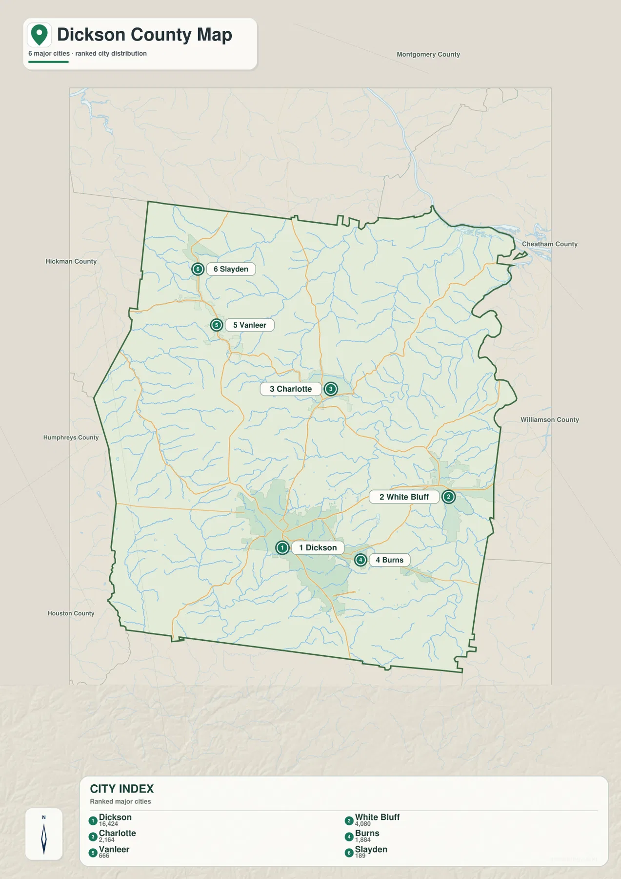
The surrounding county labels provide another useful frame. Montgomery County is to the north, Cheatham County is along the northeast and east, Williamson County touches the eastern side, and Hickman, Humphreys, and Houston counties lie around the western and southwestern edges. This matters most for places near the boundary: White Bluff is oriented toward the eastern side, while Slayden and Vanleer are much closer to the northwest edge.
The southern highway belt and the roads that fan north
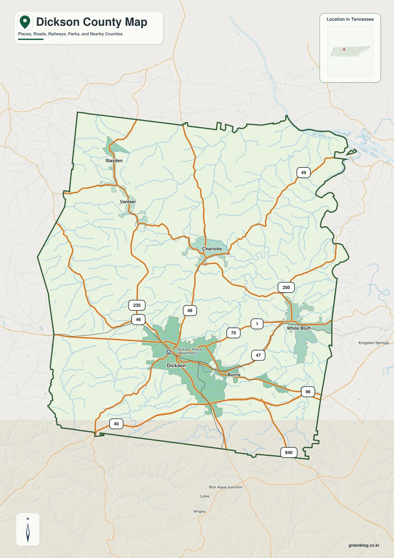
The basic county map makes the road pattern easy to see. I-40 crosses the southern part of Dickson County, south of the city of Dickson, creating a strong east-west reference line. US 70 runs through the Dickson–Burns–White Bluff side of the county, while Route 46 heads north from the Dickson area toward Vanleer and Slayden. Route 48 links the Dickson area with Charlotte, making the two principal centers easy to compare on one page.
Charlotte has its own branching pattern. Route 49 heads toward the northeast, Route 250 bends toward the White Bluff side, and other local and state routes spread west and northwest. The result is not a single corridor from one end of the county to the other. Instead, the southern road network is anchored by Dickson and I-40, while the middle of the county is organized around Charlotte and the roads radiating from it.
Farther southeast, Routes 47 and 96 appear around Burns and the approach to White Bluff, and 840 is shown near the southern edge. For ordinary map reading, there is no need to memorize every number. Mark I-40, US 70, Dickson, and Charlotte first; then add the route that serves the part of the county you actually need. That keeps a printed copy readable without losing the structure of the network.
From the Cumberland edge to the Piney River system
Water in Dickson County is split between several distinct drainage areas rather than dominated by one feature. The Cumberland River touches the northeastern edge of the county, with Jones Creek running through the eastern interior toward that side. In the southwest, West Piney River and East Piney River form a separate set of low corridors before meeting the Piney River near the southern boundary. The contrast gives the water map a clear northeast-versus-southwest structure.
Yellow Creek is another useful western reference. It follows a long valley near the western side of the county and helps separate the terrain west of the main Dickson–Charlotte axis. On the eastern half, Jones Creek stands out because its winding course can be followed through the lower ground toward the Cumberland side. Numerous smaller tributaries branch into these named streams, showing that the spaces between towns are cut by many short valleys rather than being broad, flat blocks.
Several smaller lakes are labeled around the more populated south-central area. Upper City Lake and City Lake sit near Dickson, with Luther Lake, Twin Lake, and Lake Woodhaven farther east. Indian Pond appears to the west, and Stewart Lake lies farther north. These are not county-scale barriers like a large river, but they are useful landmarks when comparing the water map with local roads or when marking a printed map for reference.
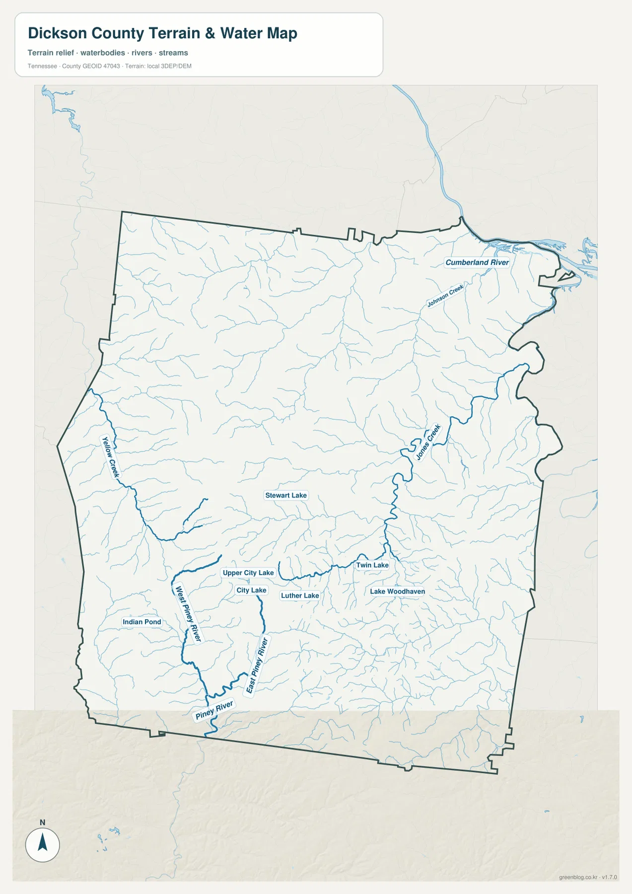
This water layer is meant for geographic orientation. It does not show flood zones, parcel boundaries, channel depth, or navigation conditions. Its value is in showing where the named streams and lakes lie relative to Dickson, Charlotte, the county boundary, and the main roads. For flood, boating, or property decisions, a purpose-built official source should be used instead.
Relief changes from 114 to 290 meters across the county
The elevation map reports an actual county range of about 114 to 290 meters, with a mean of 216 meters. The lower green tones are especially noticeable in the northeastern river area and along major creek valleys. Higher brown terrain occupies broad parts of the west, west-central interior, and portions of the south. Dickson County is not shown as a high mountain county, but the close spacing of ridges and valleys makes the surface much more broken than a flat plain.
West and southwest of Charlotte, the hillier ground is easy to distinguish from the lower drainage paths. Jones Creek creates a lower route on the eastern side, while the West Piney River valley cuts through higher terrain in the southwest. Around Dickson, the surface also rises and falls repeatedly outside the built-up area. These changes help explain why some roads bend along valleys or around ridges instead of following straight lines between towns.
The northeast is the strongest low-elevation contrast because of the Cumberland River side of the county. Elsewhere, narrow green fingers extend up the creek valleys into higher brown and tan ground. Comparing the elevation image with the water image is especially useful: many of the low strips align with named streams, making it easier to see how the drainage network fits into the terrain.
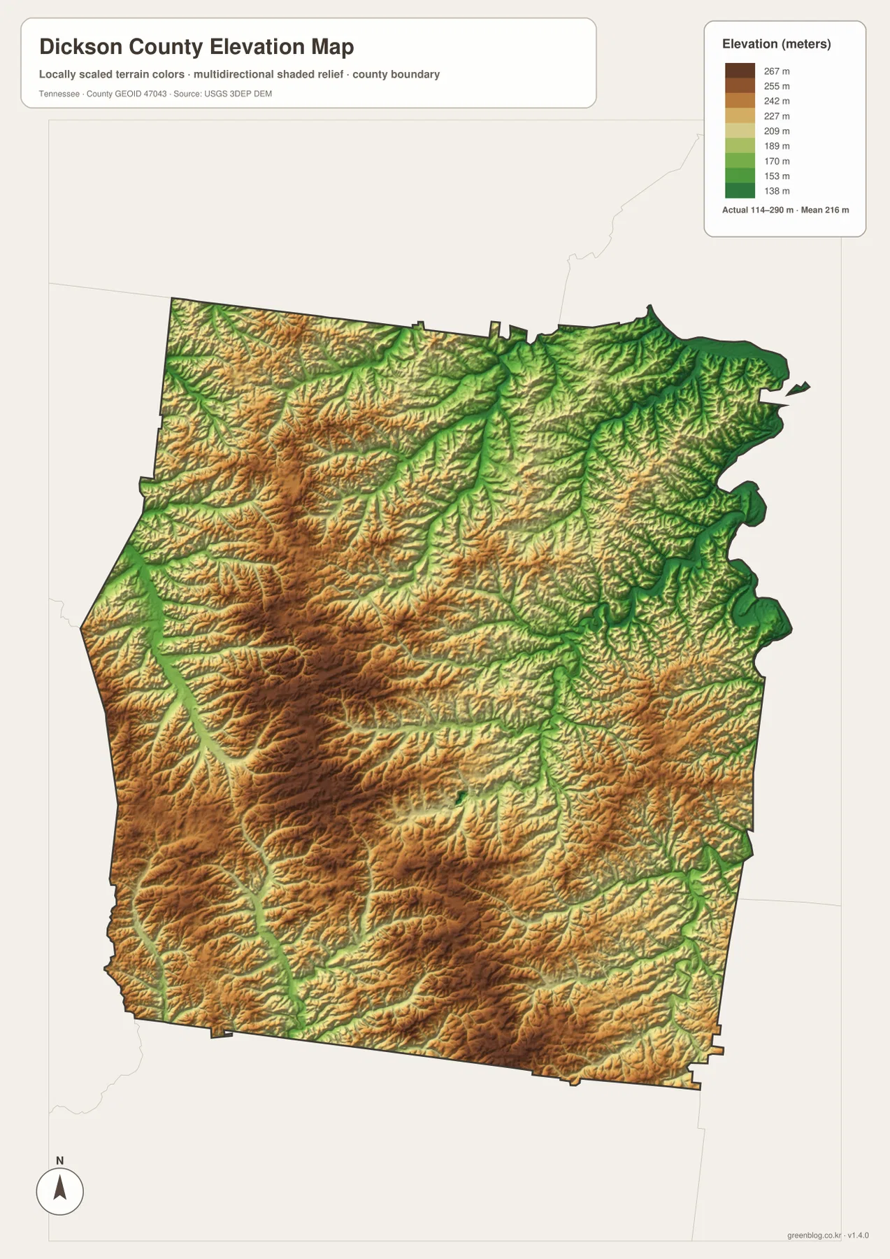
The elevation surface is a county-scale comparison, not a survey for a building site or parcel. The colors are best used to see relative highs and lows across the county. If an exact elevation is needed for engineering, construction, or property work, the generalized map should be replaced with a more detailed source.
What the four supplied maps add when read together
The county map is strongest for roads, boundaries, and the broad relationship between Dickson and Charlotte. The city map adds a different piece of information: Dickson is much larger than the other labeled communities, while Charlotte remains the administrative center. The water map then divides the county into recognizable creek and river areas, and the elevation map explains why those water lines occupy lower corridors between ridges.
Consider the Dickson-to-White Bluff side of the county. On the road map, US 70 makes the connection look like a simple east-west line through Burns. Adding the water layer reveals numerous tributaries and low areas around that corridor, while the city map shows that White Bluff is the second-largest labeled community and sits close to the eastern edge. Each image answers a different part of the same location question.
The northwest tells a different story. Vanleer and Slayden are small, widely separated labels, and the surrounding road network is less dense than the Dickson area. The terrain map shows more rolling ground across much of the west, and the water map adds Yellow Creek and many short tributaries. That combination makes the northwest look less like an extension of the I-40 corridor and more like its own rural part of the county.
Choosing the right file for print, reference, or annotation
For a quick road and boundary reference, start with the county map. If the main question is where the larger communities sit relative to one another, the city map is cleaner because it reduces the visual weight of smaller features. The water map is better for following the Cumberland edge, Jones Creek, Yellow Creek, and the Piney River system. The elevation map is the best choice when the difference between creek valleys and higher rolling land is the subject.
A3 printing gives enough room to add notes without covering the county outline. A road-focused copy can be marked with Dickson, Charlotte, I-40, and US 70 first, then the route needed for an outer community. A water-focused copy can keep the Piney River system and Cumberland side separate. For the elevation image, color printing is useful because the distinction between the lower green valleys and higher brown ridges carries most of the information.
The downloadable archive contains the same county, city, water, and elevation subjects shown in the page previews, supplied as high-resolution A3 JPG files. The WebP images are convenient for reading on the page, while the JPG originals are better suited to printing, enlargement, and offline storage.
Frequently Asked Questions
Is Dickson the county seat because it is the largest city?
No. The supplied city map ranks Dickson first at 16,424, but Charlotte is the county seat. Dickson is the stronger reference for the southern road network and I-40 side of the county, while Charlotte is the correct reference for county government and the roads branching through the central area.
Where should I look for the Cumberland River and the Piney River system?
The Cumberland River appears along the northeastern edge of the county. The Piney River system is concentrated much farther south and southwest, where West Piney River and East Piney River run through lower valleys before reaching the Piney River near the county boundary. Jones Creek is the main named eastern stream connecting the interior toward the Cumberland side.
Sources and reference data
County boundary and base geography can be checked against the U.S. Census Bureau TIGER/Line. County-specific background is available from Dickson County Government and the Tennessee State Library and Archives Dickson County fact sheet.
For detailed hydrography, see USGS National Hydrography. The elevation reference can be compared with the USGS 3D Elevation Program. The discussion on this page is centered on the place relationships visible in the supplied county maps.
Map File Information
The county, city, water, and elevation maps shown on this page are packaged as high-resolution A3 JPG files for printing, enlargement, or offline reference.
- Included Files: county map, city map, water map, elevation map
- File Type: ZIP containing 4 JPG files
Related Maps
- Coffee County Tennessee map | Manchester–Tullahoma Corridor
- Alamo to Gadsden: A Crockett County Tennessee Map
- Bedford County Tennessee Map
Green Map creates custom-edited map images using open geographic data sources such as geoBoundaries, Natural Earth, OpenStreetMap, and government open data. These maps are edited visual materials, not raw data files, and are provided for education, documents, presentations, and graphic reference.