Callahan County sits east of Abilene in west-central Texas, and its maps show a county with two very different settlement patterns. Clyde, Baird, and Putnam line up across the north near Interstate 20, while Cross Plains stands well to the southeast, away from that main east-west corridor. Streams and small lakes cut through the open land between the towns, and the elevation map shows a broad difference between higher western and central ground and lower terrain toward much of the east. This page uses those visible features to explain the county rather than simply listing map types. High-resolution A3 JPG versions of all four supplied maps are available together in the ZIP download near the end of the article.
The northern corridor is the easiest place to begin. Clyde lies on the western side of the county, close to the Abilene side of the map. Baird, the county seat, is a short distance east, and Putnam continues the same general line toward the eastern boundary. Cross Plains does not fit that row. It lies in the southeast and is reached through a different set of roads, so a trip across northern Callahan County looks quite different from a trip into the southern half. That contrast is useful for understanding why the county map, city map, water map, and elevation map each reveal something different about the same area.
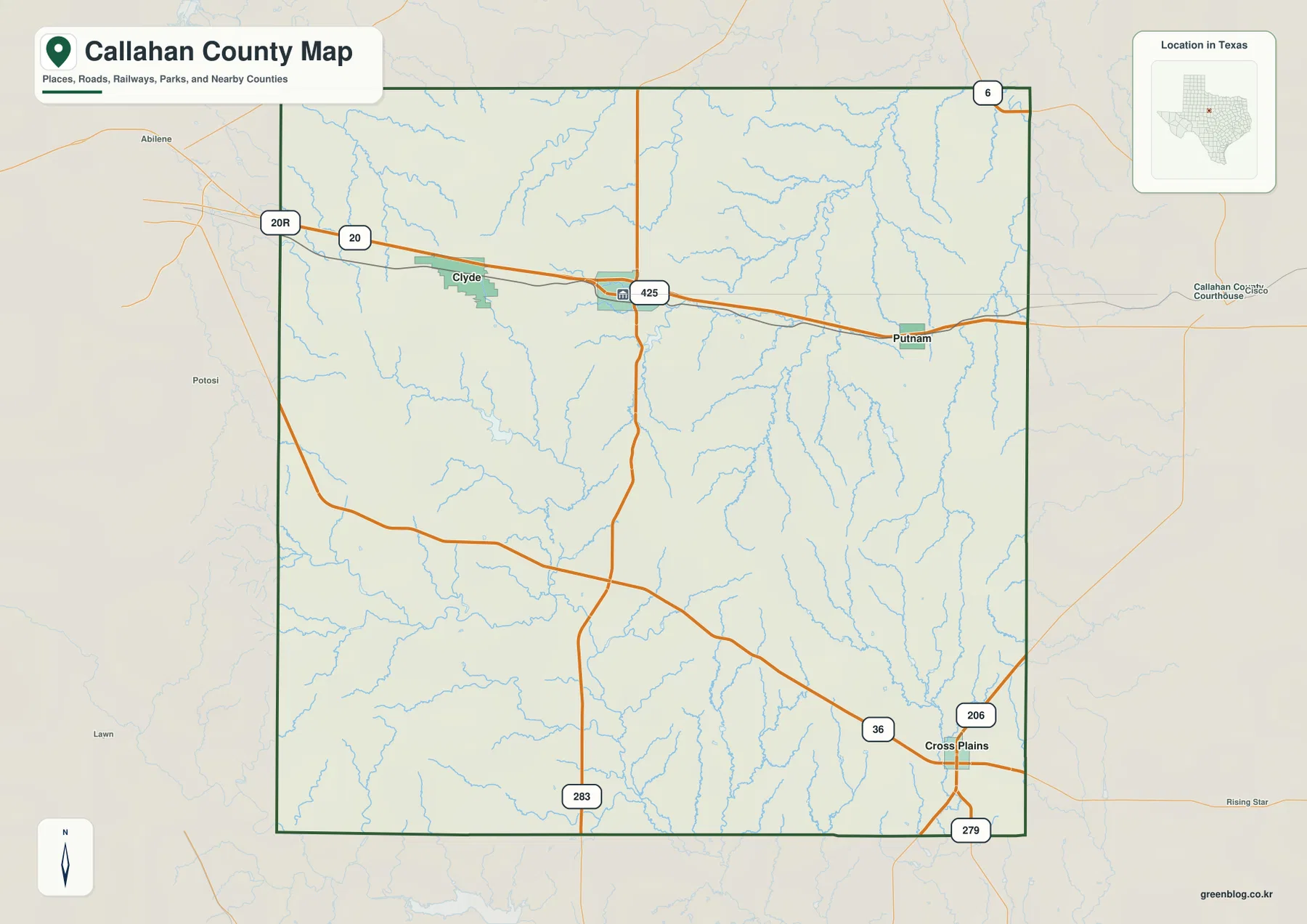
Table of Contents
Clyde, Baird, and Putnam along the northern corridor
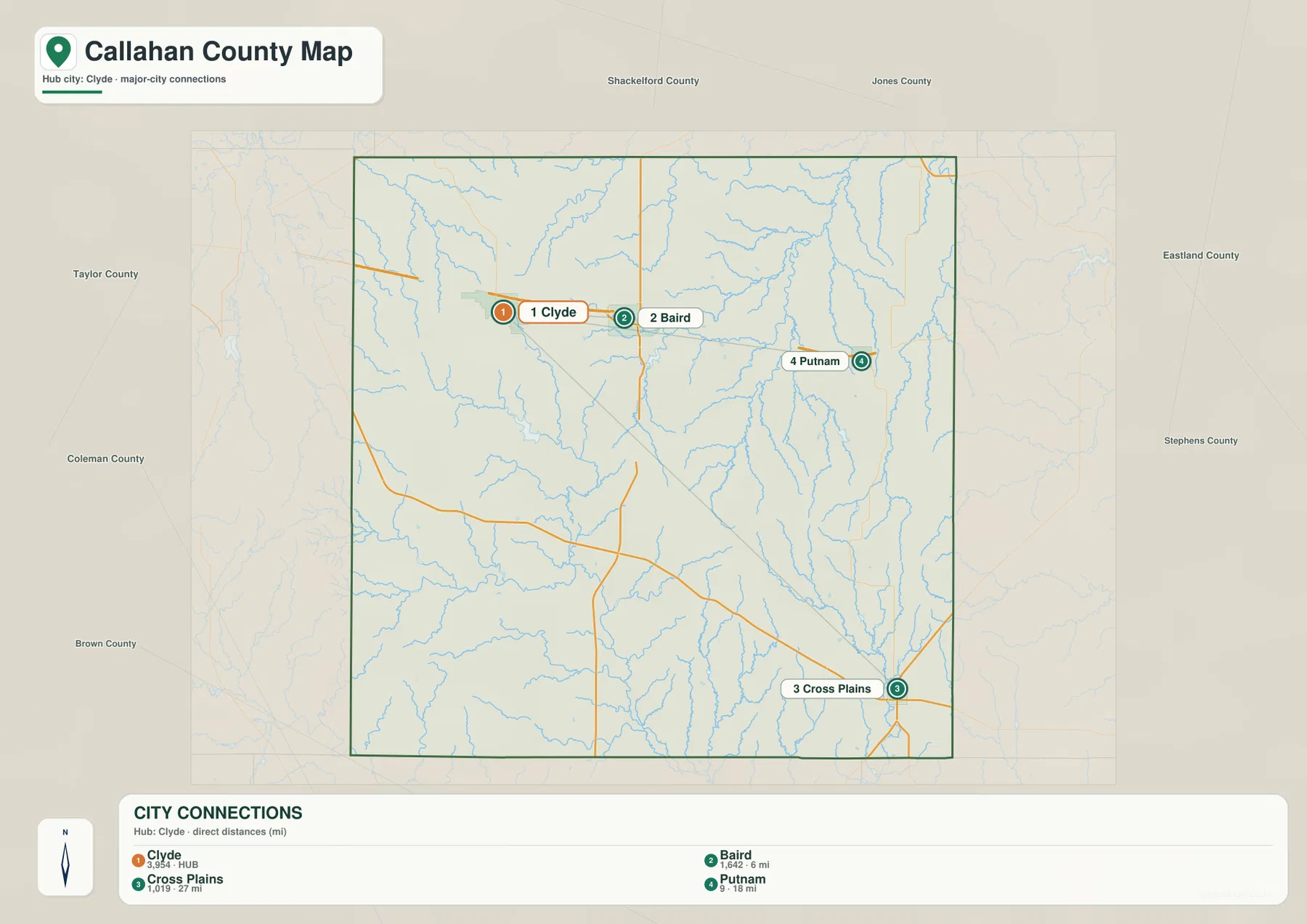
The city map uses Clyde as its hub, which makes the spacing of the county’s main labeled communities especially clear. Baird appears about 6 miles away on the same northern line, while Putnam is about 18 miles from Clyde. Cross Plains is farther away at roughly 27 miles and sits to the southeast. These distances are direct map distances rather than driving directions, but they are useful for seeing the county’s basic shape: three communities form a relatively close east-west chain in the north, whereas Cross Plains belongs to a separate southern route pattern.
Interstate 20 reinforces that northern pattern. On the general county map it runs across the upper part of Callahan County, passing the Clyde and Baird area before continuing toward Putnam and the eastern side of the county. West of Clyde, the route continues toward Abilene. East of Putnam, the map points toward the Cisco side of the region. The highway therefore provides an immediate reference for visitors who know the larger Texas road network but are less familiar with the smaller communities inside Callahan County.
Why Cross Plains belongs to a different road pattern
Cross Plains is the clearest exception to the northern arrangement. State Highway 36 crosses the southern part of the county and reaches the Cross Plains area, while routes 206 and 279 are also visible nearby. The result is a road network that serves the southeast from several directions instead of simply feeding into I-20. Someone traveling between Clyde and Baird can follow the obvious northern corridor, but a visitor heading to Cross Plains has to think about the county’s southern roads and the greater distance between settlements.
The county edges help explain those routes. The city map labels Taylor County to the west, Shackelford County and Jones County to the north, Eastland County and Stephens County to the east, Brown County to the south, and Coleman County to the southwest. These surrounding names turn the boundary into a useful orientation tool. Clyde is closest to the Abilene-facing side, Putnam is near the eastern side, and Cross Plains occupies a southeastern position that makes Brown and Eastland County directions more relevant than they are for the I-20 towns.
There is also a local historical reason the northern line of towns deserves attention. The Handbook of Texas notes that the Texas and Pacific Railway was built through the county in 1880–81 and that stations at Putnam, Baird, and Clyde helped those places develop. A modern highway map should not be treated as a railroad map, yet the shared east-west placement of those three communities is easier to understand with that history in mind. It is a county-specific pattern rather than a generic feature that could be copied to any rural Texas map.
Small lakes and branching creeks across Callahan County
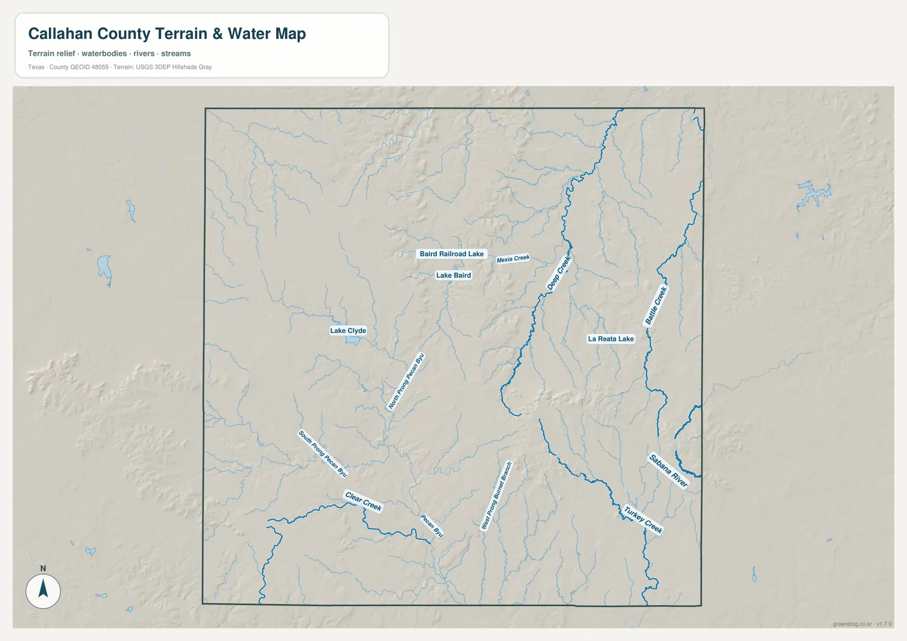
The terrain-and-water map shifts attention away from highways and toward the numerous channels crossing the county. Lake Clyde is labeled in the western part of the map, while Lake Baird and Baird Railroad Lake sit closer to the Baird area. These named lakes are relatively small compared with the large reservoirs found elsewhere in Texas, but they are valuable local reference points because they connect familiar community names with the county’s drainage network.
Farther east, Deep Creek and Battle Creek stand out as longer, more prominent blue lines. Turkey Creek appears in the southeast, and Clear Creek is labeled toward the southwest. In the southern half, Pecan Bayou and its North Prong and South Prong labels make it possible to follow a family of connected waterways rather than viewing each stream as an isolated mark. The dense collection of smaller tributaries around these named channels is one reason the water map looks much more detailed than the general road map.
The shaded relief behind the streams adds another layer of information. Creek valleys appear between ridges and rolling ground, so the water lines can be compared with the shape of the terrain instead of being treated as flat symbols. Around Deep Creek and Battle Creek, several channels run for long distances through the eastern side. In the south, the Pecan Bayou branches spread across a wider area. Around Lake Clyde and the Baird lakes, shorter local drainage lines provide a different pattern. These contrasts help explain why a single description such as “flat ranch country” would miss much of what the map actually shows.
A 410–699 meter elevation range and a clear west-to-east change
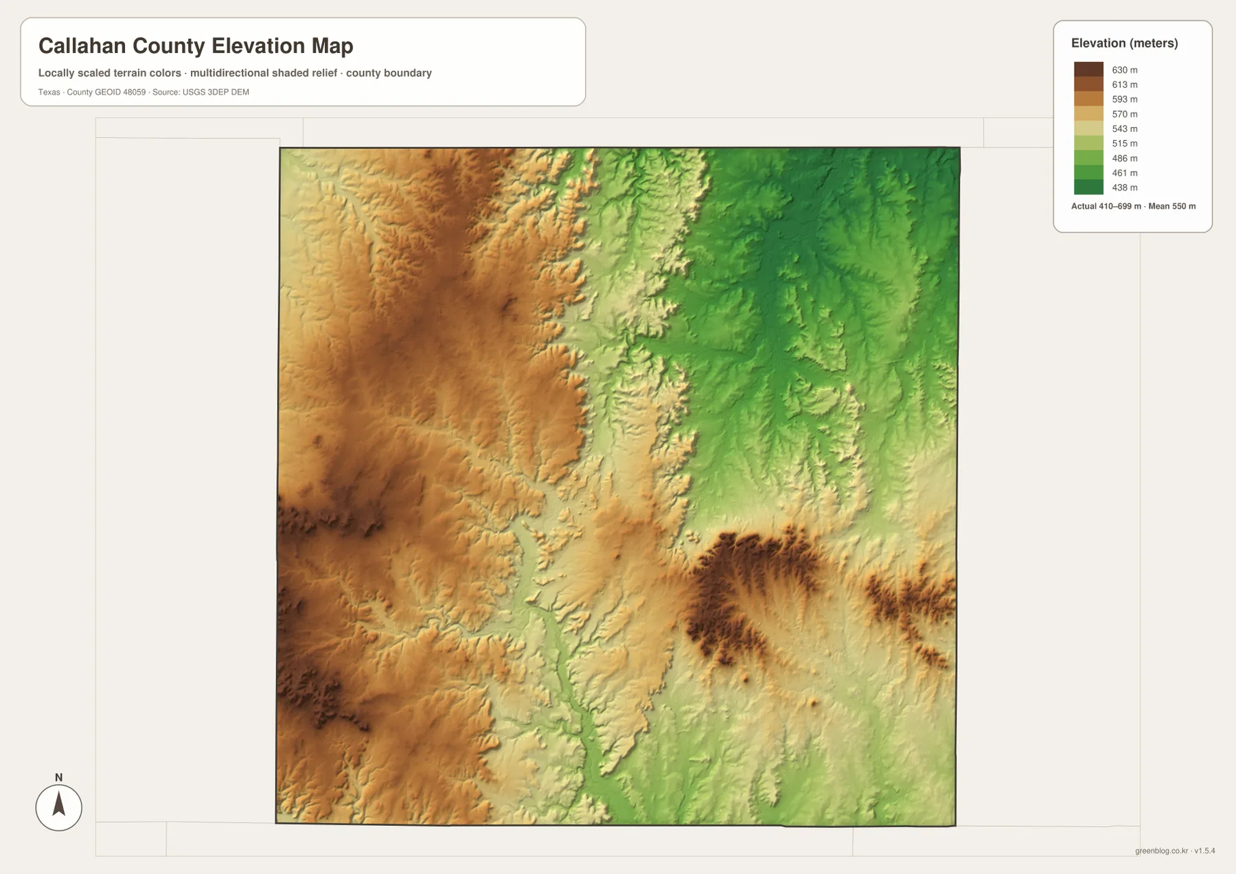
The elevation map gives the strongest visual explanation for the county’s uneven terrain. Its legend shows an actual range of about 410 to 699 meters, with a mean elevation of roughly 550 meters. Browns and oranges dominate much of the west and west-central area, indicating higher ground. Greens become more common across the eastern side, where elevations are generally lower. Between those broad zones, the center of the county contains a broken transition of ridges, slopes, and lower corridors rather than one perfectly straight dividing line.
A noticeable high ridge also appears in the southeast, surrounded by lower green terrain. That feature is useful when comparing the elevation map with the road map around Cross Plains. Roads in this part of the county cross a landscape with more relief than a plain road diagram suggests. In the northeast and east, the lower green areas correspond more closely with the long creek systems seen on the water map. The relationship is not a one-to-one rule for every stream, but the two maps together make the valley-and-upland pattern much easier to recognize.
The difference between the mapped minimum and maximum is close to 289 meters. For a county map page, that number matters because it prevents the terrain from being reduced to a vague description. A reader can see that the western side is not merely colored differently for decoration; it represents substantially higher ground than many eastern areas. The elevation map is therefore the best choice when the question is not “Where is Baird?” or “Which road reaches Cross Plains?” but “How does the land rise and fall across the county?”
Match the map to the question you are trying to answer
Use the general county map when you need the broadest combination of boundaries, towns, highways, and surrounding places. It is the fastest way to locate I-20, State Highway 36, the Cross Plains road cluster, and the county outline on one page. The city map is better when settlement spacing is the main concern. Its Clyde-centered layout makes the relative positions of Baird, Putnam, and Cross Plains easy to compare without the extra detail of every minor stream.
Choose the water map for lakes, creeks, and bayou branches. It is the only supplied image that labels Lake Clyde, Lake Baird, Baird Railroad Lake, Deep Creek, Battle Creek, Turkey Creek, Clear Creek, and the Pecan Bayou branches together against shaded relief. Choose the elevation map when height is the main topic. Its color scale makes the higher western ground, the lower eastern areas, and the southeastern ridge visible even before you read the meter values in the legend.
Some questions require more than one map. A Cross Plains trip can begin with the city map to establish direction, continue with the county map to identify Highway 36 and routes 206 and 279, and then use the elevation and water maps to understand the surrounding ridges and drainage. Around Clyde and Baird, the road map can be paired with the water map to locate Lake Clyde, Lake Baird, and nearby streams. This is more useful than forcing every detail onto one crowded image, and it lets each map remain readable for printing.
Printing and practical reference
The downloadable files are high-resolution A3 JPGs, so they work well when the smaller web preview is not enough. For a classroom activity about transportation, the general or city map keeps town and road relationships easy to see. A lesson on local drainage can use the water map to trace named creeks and Pecan Bayou branches. The elevation map works best in color because the transition from green to tan, orange, and brown carries much of the information. If the page is being used for a report or presentation, selecting only the map that supports the point will usually produce a clearer result than placing all four images on the same slide.
For field reference, these maps should be treated as geographic orientation rather than live navigation. They do not show current closures, construction, private-property access, or changing road conditions. Their value is in showing how the county is organized: the I-20 communities across the north, Cross Plains in the southeast, the many creek systems crossing the interior, and the substantial elevation change from one side of the county to the other. That combination gives a reader a useful mental map before checking more specialized or real-time sources.
Frequently Asked Questions
How are Clyde, Baird, and Putnam arranged on the map?
They form an east-west sequence across the northern part of Callahan County near I-20. On the city map, Baird is shown about 6 miles from Clyde and Putnam about 18 miles from Clyde, while Cross Plains is separated from that line in the southeast.
What elevation range does the Callahan County map set show?
The elevation map legend gives an actual range of roughly 410 to 699 meters and a mean near 550 meters. Much of the west and west-central county is higher, many eastern areas are lower, and a distinct higher ridge appears in the southeast.
Which map should I use to find named lakes and creeks?
Use the terrain and water map. It labels Lake Clyde, Lake Baird, Baird Railroad Lake, Deep Creek, Battle Creek, Turkey Creek, Clear Creek, and Pecan Bayou branches, while also showing shaded terrain around those waterways.
Map File Information
The ZIP contains high-resolution A3 JPG files for the Callahan County general map, city map, terrain and water map, and elevation map. Use these larger files when you need more detail than the web previews provide.
- File Type: ZIP containing 4 JPG files
Related Maps
- Shackelford County Texas map
- Taylor County Texas map
- San Saba County Texas map
- Runnels County Texas map
- Palo Pinto County Texas map
Sources and references
- Handbook of Texas – Callahan County for county history and the development of Baird, Clyde, and Putnam.
- U.S. Census Bureau TIGER/Line Shapefiles for official boundary, road, and place reference data.
- USGS National Hydrography for U.S. water and drainage reference data.
- USGS 3D Elevation Program for official elevation and terrain data.
Green Map creates custom-edited map images using open geographic data sources such as geoBoundaries, Natural Earth, OpenStreetMap, and government open data.
These maps are edited visual materials, not raw data files, and are provided for education, documents, presentations, and graphic reference.