Possum Kingdom Lake and Brazos River Relief on a Palo Pinto County Map

You can download four high-resolution A3 JPG maps of Palo Pinto County, Texas, in one ZIP directly from this page. The package includes a general county map, a Mineral Wells-centered city-connections map, a terrain-and-water map, and an elevation map. The supplied maps show Mineral Wells, Graford, Palo Pinto, Strawn, Mingus, Santo, roads such as 533, 254, 337, 16, 180, 108, 193, 80, 281, and 20, plus Possum Kingdom Lake, Brazos River, Palo Pinto Creek, several named tributaries, and an actual elevation range of about 219 to 465 meters.

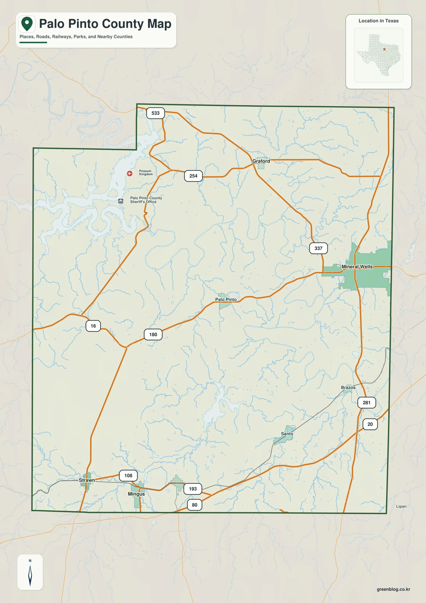
Palo Pinto County is defined as much by relief and water as by its towns. Mineral Wells anchors the eastern side, Graford lies north of the center, and Palo Pinto sits farther southwest along Route 180. Strawn and Mingus occupy the rugged southwestern corner. Possum Kingdom Lake fills a deeply cut northwestern valley, while Brazos River winds through the central and eastern interior. The elevation map makes those relationships especially clear: high western and southwestern ridges stand well above the broad river and creek valleys.

Route 180 links Mineral Wells with Palo Pinto across the county’s central relief

Mineral Wells is the largest developed area on the general county map and provides the easiest first orientation. Route 337 runs through the eastern side, while Route 180 extends west toward Palo Pinto. Farther west, Route 16 continues toward the county edge. This east-west corridor is useful because it crosses several terrain zones rather than remaining within one flat urban belt.

Graford lies north of the central corridor near Route 254. Route 533 appears closer to the northwestern boundary, where the road network begins to interact with the highly irregular Possum Kingdom Lake country. The space between Graford and Mineral Wells contains many stream lines and winding roads, making the northern interior feel much more dissected than the general settlement pattern suggests.

Santo sits in the south-central part of the county, while Strawn and Mingus occupy the southwest. Roads 108, 193, and 80 provide useful references around those two towns. Along the eastern edge, roads 281 and 20 help locate the Brazos side. These southern communities lie among stronger ridges and valleys than the eastern Mineral Wells area, which becomes obvious once the elevation layer is added.

Palo Pinto County Texas map showing Mineral Wells, Graford, Palo Pinto, Strawn, Mingus, Santo, and major numbered roads
General Palo Pinto County map showing Mineral Wells, Graford, Palo Pinto, Strawn, Mingus, and the principal road references

Direct distances from Mineral Wells show how far the southwestern towns sit from the eastern hub

The city-connections map uses Mineral Wells as the hub and links it to Graford, Gordon, Mingus, and Strawn. The labels show about 12 miles to Graford, 24 miles to Gordon, 26 miles to Mingus, and 29 miles to Strawn. These are straight-line distances between mapped points, not driving distances or travel-time estimates.

Direction adds useful context. Graford is northwest of Mineral Wells, while Gordon, Mingus, and Strawn form a broader southwestern group. The large gap to Strawn and Mingus helps explain why the southwest feels geographically separate even though the towns remain within the same county. Returning to the general map after viewing the direct connections makes Route 180 and the southern road network easier to interpret.

The lower CITY CONNECTIONS panel also prints 15,244 for Mineral Wells, 654 for Graford, 522 for Strawn, 460 for Gordon, and 380 for Mingus. No year is visible on the supplied image, so this article treats those figures only as values printed on the map rather than confirmed current population counts. The main value of the layer is the direction and distance comparison.

Palo Pinto County city-connections map using Mineral Wells as the hub with Graford about 12 miles, Gordon 24 miles, Mingus 26 miles, and Strawn 29 miles away
Mineral Wells-centered connections showing the direct distance to Graford, Gordon, Mingus, and Strawn

Possum Kingdom Lake fills the county’s most dramatic northwestern water-and-relief setting

Possum Kingdom Lake is the strongest water feature in the northwest. Its long branching shoreline reaches through deeply incised terrain and creates numerous narrow coves and peninsulas. The water map makes the irregular northwestern boundary much easier to understand, while the elevation layer shows steep relief around many parts of the lake.

Dark Valley Creek extends southeast of the lake area. Elm Creek occupies another central drainage corridor farther east, and Turkey Creek lies beyond it. These three named creeks help trace the transition from the rugged lake country into the lower Brazos River system.

Brazos River and Palo Pinto Creek divide the central and southern interior

Brazos River follows a broad series of bends through the central-eastern part of the county. Its course is far from straight, and wide lowlands appear around several meanders. On the elevation map, the river corridor is consistently greener than the higher ridges to the west and southwest.

Palo Pinto Creek crosses the southern part of the county and is associated with a cluster of named water bodies, including Lake Palo Pinto, Johnson Lake, and James Lake. Lake C B Long and Tucker Lake lie farther west. Big Sunday Creek and Buck Creek provide additional southeastern drainage references, creating a complicated network of lower valleys below the central uplands.

Eagle Creek is labeled in the west-central interior and helps separate the Possum Kingdom drainage from the southern Palo Pinto Creek system. The terrain-and-water map is intended for geographic reference rather than flood mapping, parcel boundaries, or legal water limits. Its best use is matching named rivers, creeks, and lakes to towns and roads on the general map.

Palo Pinto County water map showing Possum Kingdom Lake, Brazos River, Palo Pinto Creek, Dark Valley Creek, Elm Creek, Turkey Creek, and Lake Palo Pinto
Terrain-and-water map showing Possum Kingdom Lake, the Brazos River meanders, Palo Pinto Creek, and major tributary valleys

Western ridges rise more than two hundred meters above the major river valleys

The elevation map reports an actual range of about 219 to 465 meters and a mean elevation of about 319 meters. The highest brown terrain is concentrated in the west and southwest, with additional high ridges in the north. Brazos River and many of the creek corridors appear as broad or narrow green lowlands through the center and east.

The Possum Kingdom Lake area contains some of the strongest short-distance relief changes. High ridges surround deeply cut lake arms and tributary valleys, so tan, brown, and green colors alternate rapidly. This terrain explains why the northwestern road and shoreline pattern looks so irregular on the general map.

Brazos River creates another major low corridor. Its large bends occupy low green terrain, with long narrow ridges rising on either side. Palo Pinto Creek and Big Sunday Creek form smaller but still distinct valleys farther south. The southwestern Strawn-Mingus side remains much higher overall than the eastern river country.

The difference between the displayed minimum and maximum elevation is about 246 meters. The elevation layer is best used to compare the relative height of Mineral Wells, Graford, Palo Pinto, Strawn, Possum Kingdom Lake, and the Brazos River system rather than for site-level engineering or survey measurements.

Palo Pinto County elevation map showing an actual range from about 219 to 465 meters and a mean elevation of 319 meters
Elevation map showing high western and southwestern ridges descending into Possum Kingdom Lake, Brazos River, and major creek valleys

The Strawn-Mingus uplands contrast sharply with the Mineral Wells and Brazos lowlands

The southwest around Strawn and Mingus is one of the best places to see the county’s rugged high ground. Roads 108, 193, and 80 cross a landscape of closely spaced ridges and drainage cuts. On the terrain map, several creek valleys break through the higher surfaces, making the area much rougher than a road-only view suggests.

Moving east toward Mineral Wells and the Brazos side changes the pattern. The river meanders occupy broader low terrain, and roads 281 and 20 pass through a generally lower eastern setting. Comparing the same east-west direction on the general, water, and elevation maps gives Palo Pinto County a distinct identity built around lake country, river valleys, and rugged western relief.

A practical reading order is to locate Mineral Wells, Graford, Palo Pinto, and the southwestern towns first, match Possum Kingdom Lake, Brazos River, and Palo Pinto Creek to the same positions, and then compare elevation. Small labels such as Dark Valley Creek and Big Sunday Creek are often easier to inspect in the downloadable high-resolution JPG files than in the browser previews.

Frequently Asked Questions

What direct distances are shown from Mineral Wells?

The city-connections map shows about 12 miles from Mineral Wells to Graford, 24 miles to Gordon, 26 miles to Mingus, and 29 miles to Strawn. These are straight-line map distances, not driving distances.

Which water features are the best starting points?

Possum Kingdom Lake is the clearest northwestern reference, while Brazos River organizes much of the central and eastern drainage. Palo Pinto Creek and Lake Palo Pinto are useful in the south, and Dark Valley Creek, Elm Creek, and Turkey Creek help locate the northern interior.

What elevation range is shown for Palo Pinto County?

The supplied elevation map reports an actual range of about 219 to 465 meters and a mean elevation of about 319 meters. The west and southwest are generally higher, while Brazos River and many creek valleys occupy lower terrain.

Sources and Reference Data

Map File Information

Download four high-resolution A3 JPG maps of Palo Pinto County, Texas, in one ZIP file.

  • Included Files: county map, city-connections map, terrain and water map, elevation map
  • File Type: JPG
Download Map Files

Green Map creates custom-edited map images using open geographic data sources such as geoBoundaries, Natural Earth, OpenStreetMap, and government open data.

These maps are edited visual materials, not raw data files, and are provided for education, documents, presentations, and graphic reference.
Leave a Comment

Your email address will not be published. Required fields are marked *

Scroll to Top