Lee County sits in southwestern Georgia, with Leesburg near the middle of the county and Smithville close to the northwestern edge. The maps on this page separate four kinds of information that are easy to lose when everything is placed on one image: the county boundary and roads, the two incorporated cities, named creeks and ponds, and the county’s elevation. You can review each WEBP preview below and download a ZIP containing four high-resolution A3 JPG maps when you need a larger file for printing, classwork, reports, or local-reference projects.
The most useful feature of this set is the way the maps can be compared. The road map places Leesburg among routes labeled 19/3, 32, and 195, while the water map shows Muckalee Creek running through the county and Kinchafoonee Creek farther west. On the elevation map, those creek corridors line up with lower ground, while broader areas in the north and northeast rise above them. That connection between towns, roads, water, and relief gives a more complete view of Lee County than a single outline or city marker could provide.
Table of Contents
Leesburg at the Center of Lee County
The general county map is the best starting point because it combines the boundary, selected places, roads, and visible water features. Leesburg stands near the center-south portion of the county, where several numbered routes meet. The map labels 19 and 3 along the north-south corridor through Leesburg, 32 crossing the area, and 195 connecting into the same central network. Smithville appears much farther north and west, close to route 118. Additional route labels around the county include 82, 520, 133, 91, and 377, giving the reader several fixed points for comparing the northern, central, and southern parts of Lee County.
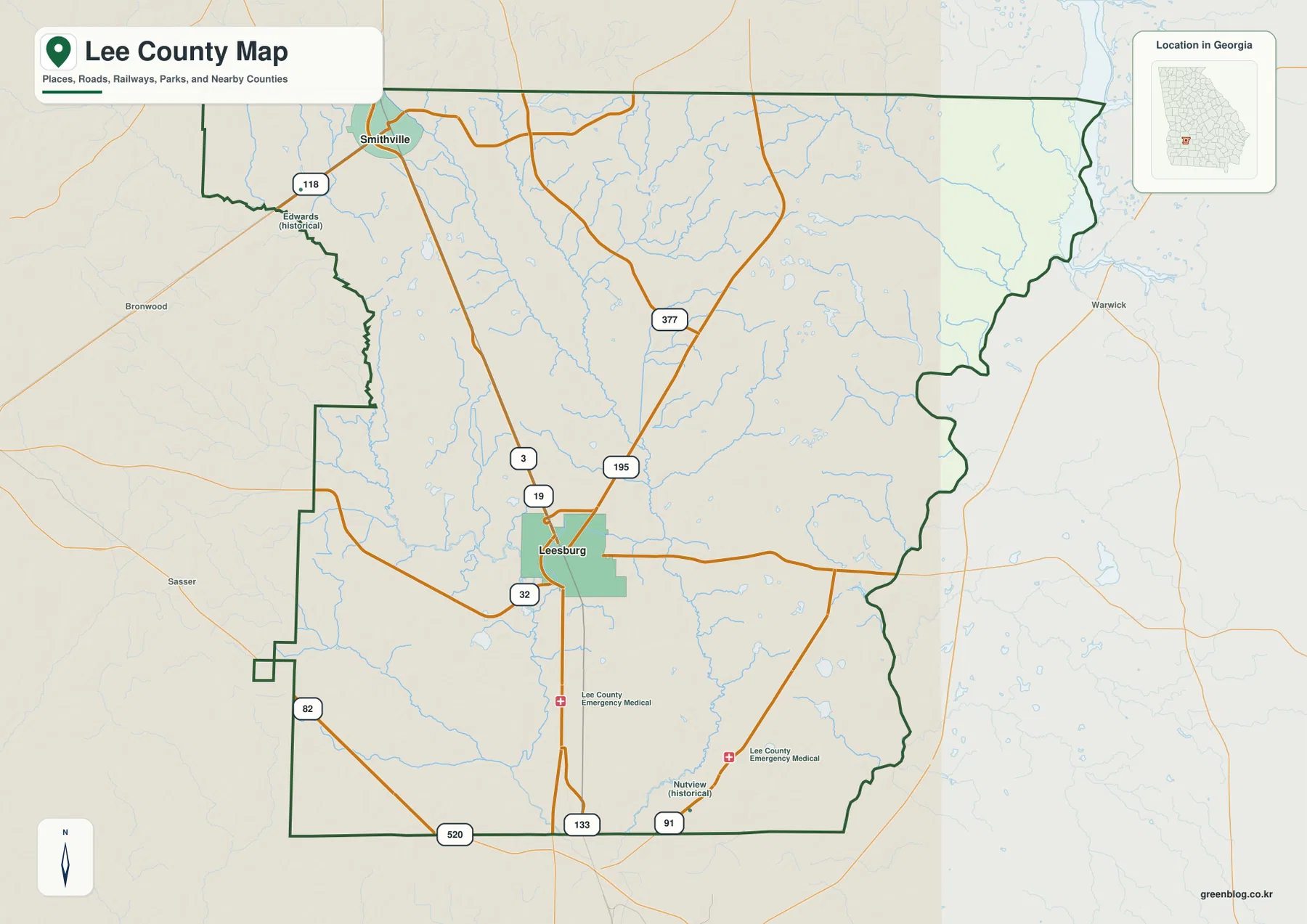
The county outline itself is worth noticing. The western side has several steps and notches rather than one straight boundary, and the eastern side also bends around an irregular edge. Nearby labels such as Brownwood, Sasser, and Warwick help place Lee County within the surrounding part of southwest Georgia. The map also marks historical labels including Edwards and Nutview, which can be useful when a local name appears in older records or family-history research even though it is not one of the county’s two incorporated cities shown on the city map.
| State | Georgia |
|---|---|
| County | Lee County |
| County seat | Leesburg |
| Incorporated cities shown | Leesburg and Smithville |
| Named water features | Muckalee Creek, Muckaloochee Creek, Kinchafoonee Creek, ponds and smaller streams |
| Elevation map range | About 55–117 m; mean about 81 m |
| Download | Four high-resolution A3 JPG maps in one ZIP |
The existing county material also identifies 1825 as Lee County’s establishment year. For reading the maps, however, the most important local relationship is present-day location: Leesburg is the county seat and central reference point, while Smithville marks the northwestern part of the county. The maps also place Lee County beside Sumter County to the north, Terrell and Dougherty counties to the west, Worth County to the east, and Crisp County toward the southeast. Those neighboring labels make the county easier to orient without needing a separate statewide map.
Two Incorporated Cities and a Road Network Focused on Leesburg
The city map strips away much of the road detail and makes the separation between Leesburg and Smithville obvious. Leesburg is ranked first on the map and sits in the central part of the county, while Smithville is ranked second near the northwestern boundary. This is not a street map of either city; its purpose is to show where the two incorporated places sit inside the full county outline and how far apart they are in relation to the surrounding counties.
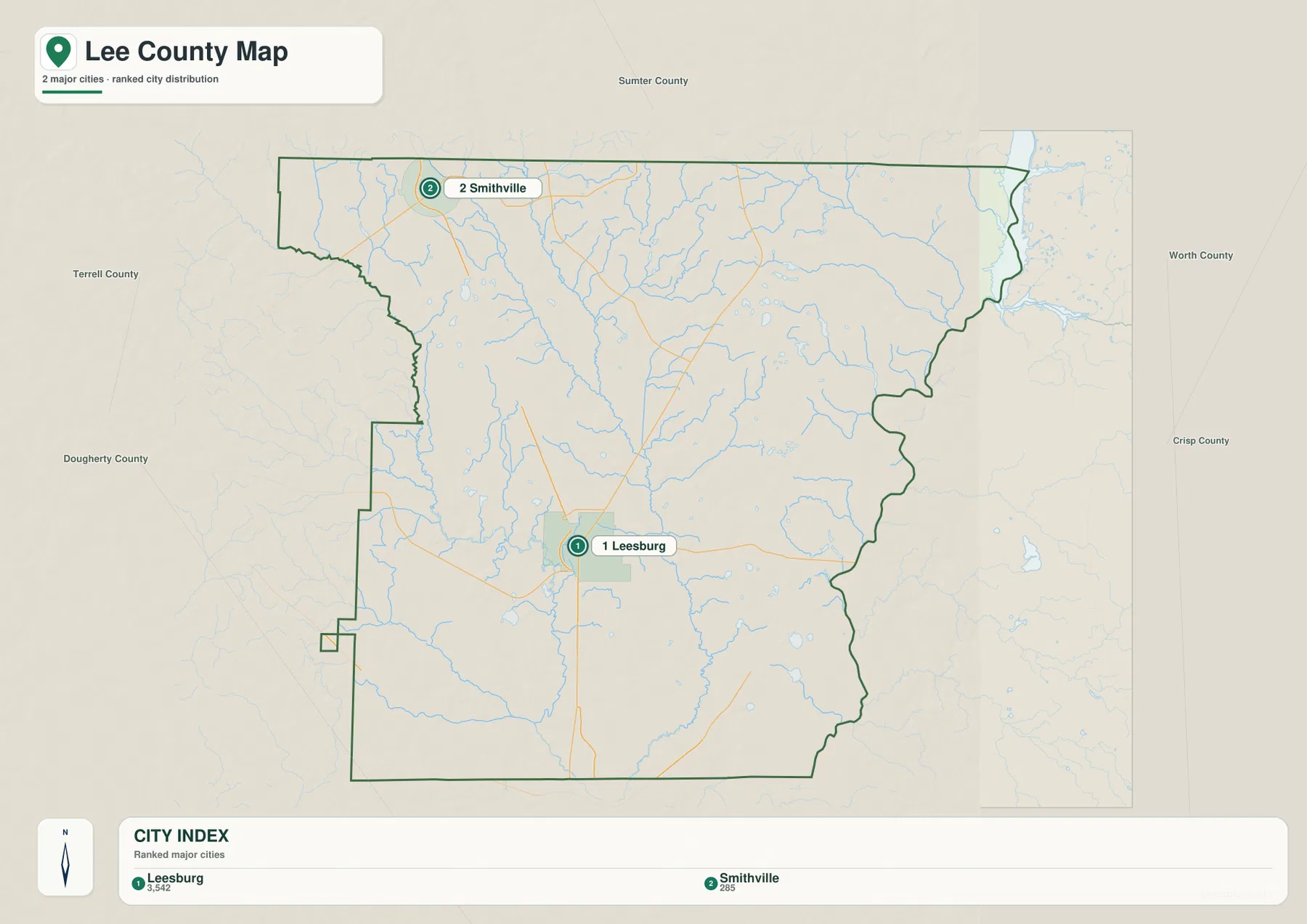
The city map also provides a clean view of the county’s regional orientation. Sumter County lies beyond the northern edge. Terrell County and Dougherty County are shown to the west, Worth County is on the east side, and Crisp County appears farther southeast. Because Leesburg is close to the middle of the county, it works well as the main reference point when comparing directions. Smithville, by contrast, is useful for identifying the northwestern corner and the approach toward the Sumter and Terrell county sides.
When the city map is compared with the general map, Leesburg’s role in the road pattern becomes clearer. Routes labeled 19/3 run north-south through the Leesburg area, route 32 crosses the central part of the county, and 195 connects into the same network. Smithville is associated with route 118 farther north. The southern portion contains labels such as 82, 520, 133, and 91. These maps are not intended to replace navigation software or a complete road atlas, but they are useful when a reader needs to know which part of Lee County a town or major numbered route occupies.
Muckalee and Kinchafoonee Creeks Define the Water Map
Water becomes the dominant feature on the hydrography map. Muckalee Creek enters from the north and continues through the central part of Lee County toward the south. Muckaloochee Creek runs through the northwestern portion of the county, while Kinchafoonee Creek follows the western and southwestern side. Fowlstown Creek is labeled in the southwest, and Chokee Creek appears in the northeast near Sadlers Millpond. Many smaller tributaries branch between these named streams, so the county’s drainage is much more detailed than the pale blue lines on the general map first suggest.
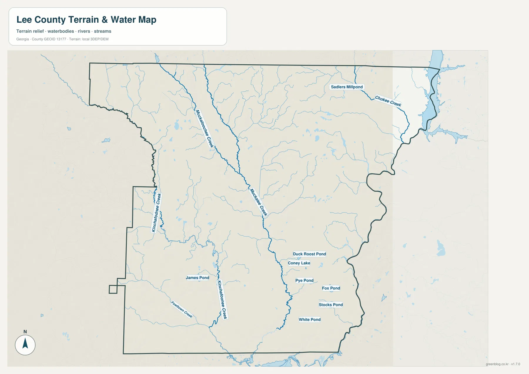
The southeastern part of the county contains a cluster of named small water bodies, including Duck Roost Pond, Coney Lake, Pye Pond, Fox Pond, Stocks Pond, and White Pond. James Pond is labeled farther west, and smaller unnamed or lightly labeled water features are scattered throughout the map. These features matter because they show that Lee County’s water geography is not limited to one major channel. Instead, creeks, tributaries, millponds, and ponds are distributed across much of the county.
This water map should be used as a location reference, not as a flood-hazard or water-quality map. It does not identify regulatory flood zones, property boundaries, stream setbacks, or current water conditions. For a classroom project, local-history description, or general geographic overview, however, it gives a much clearer picture of the named waterways than the road map. It is also especially useful beside the elevation map, because several of the most prominent creek corridors correspond to lower ground.
A 55–117 Meter Elevation Range Reveals Creek Lowlands
The elevation map reports an actual range of about 55 to 117 meters across Lee County, with a mean near 81 meters. Those numbers describe a county without mountains, but the shaded relief still shows meaningful local differences. Higher ground is concentrated across broad parts of the north and northeast, where brown and tan colors are more common. A long green lowland follows Muckalee Creek through the middle of the county, and another lower corridor traces Kinchafoonee Creek on the western side.
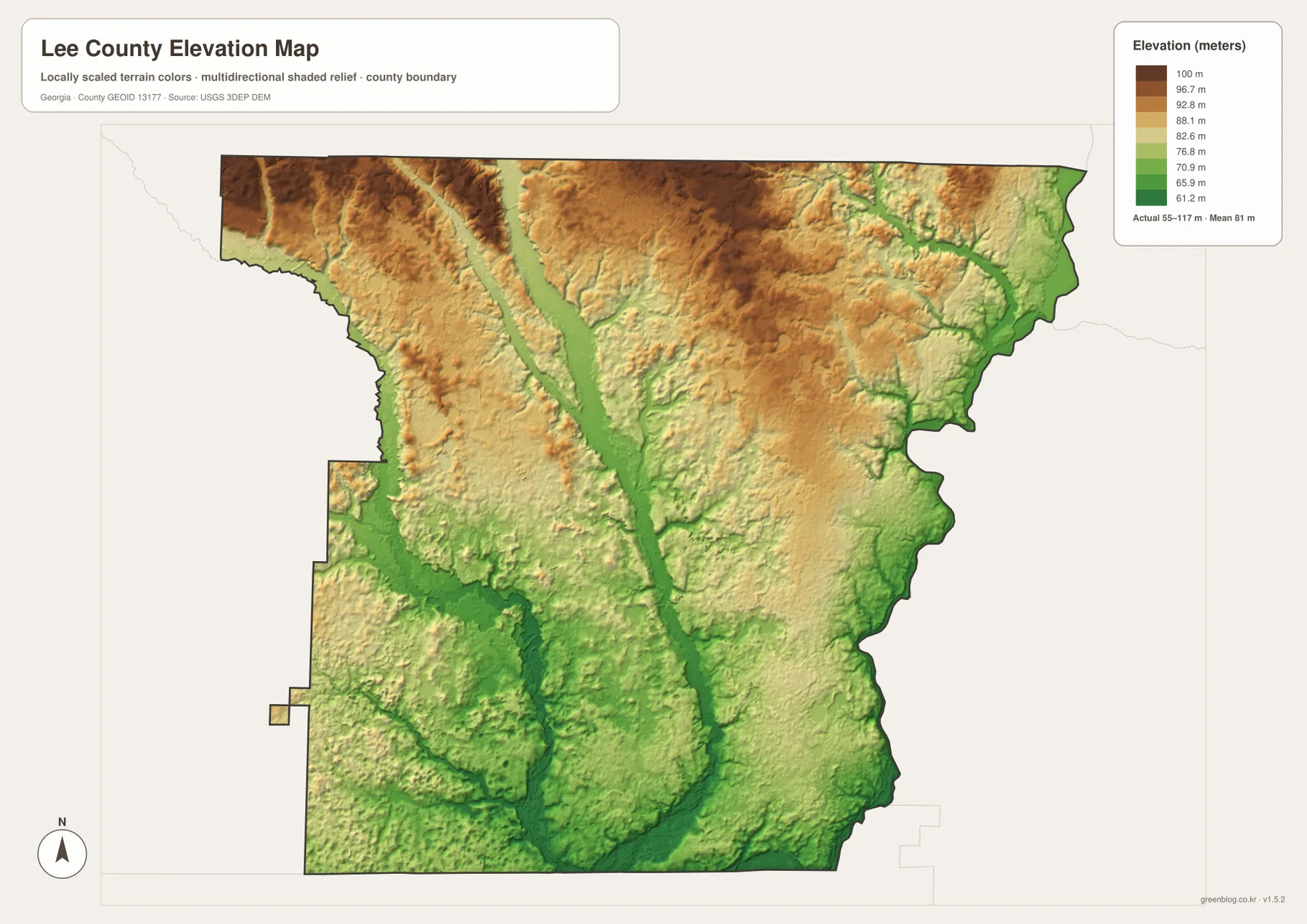
The central lowland is one of the clearest features in the entire four-map set. On the water map it appears as the Muckalee Creek corridor; on the elevation map it becomes a continuous band of lower terrain. The same relationship is visible on the western side where Kinchafoonee Creek passes through a lower valley. Farther north, the ground rises into a more uneven surface, and the northeastern part of the county contains several higher ridges cut by smaller drainage lines.
Near the south, lower ground spreads across a broader area where streams continue toward the county boundary. The difference between this southern lowland and the higher northern terrain is gradual rather than mountainous, which is why it may be easy to miss on a conventional road map. The shaded elevation image is useful for seeing those subtle changes. It should not be treated as a parcel-level survey or a substitute for engineering elevation data, but it provides an effective countywide picture of where land is relatively high or low.
Choosing the Right Lee County Map
Each image is designed for a different question. The general map is the quickest choice for a reader who needs the county boundary, Leesburg, Smithville, and major numbered roads on one page. The city map removes much of that detail and emphasizes the two incorporated cities and the counties around Lee County. The water map is better for locating named creeks, tributaries, and ponds, while the elevation map is the clearest choice for comparing the higher north and northeast with lower creek corridors through the center, west, and south.
- County map: use it for boundaries, Leesburg and Smithville, major road numbers, and general orientation.
- City map: use it to compare the two incorporated cities and neighboring county directions without extra detail.
- Water map: use it for Muckalee Creek, Kinchafoonee Creek, Muckaloochee Creek, smaller streams, and named ponds.
- Elevation map: use it to compare the approximately 55–117 m range and see lower terrain along creek corridors.
For reports or presentations, it can be helpful to pair two maps instead of trying to explain every feature from one image. The general map plus the city map works well for settlement and road orientation. The water map plus the elevation map is more useful when the subject is terrain, drainage, or the relationship between creeks and lower land. Keeping those topics separate also makes labels easier to read.
The images displayed in the article are WEBP previews optimized for the page. The ZIP uses the larger JPG versions, so the downloadable files are the better choice when you need to zoom in, place a map in a document, or print it at a larger size.
Frequently Asked Questions
Where are Leesburg and Smithville within Lee County?
Leesburg is near the central part of the county and serves as the county seat. Smithville is much farther northwest, close to the northern and western sides of the county. The city map makes the separation between the two places especially easy to see.
Which creeks stand out on the Lee County water map?
Muckalee Creek is the main named channel running through the central part of the map. Muckaloochee Creek appears in the northwest, and Kinchafoonee Creek follows the western and southwestern side. The map also labels Fowlstown Creek, Chokee Creek, several ponds, and many smaller tributaries.
How much does elevation vary across Lee County?
The elevation map gives an actual range of about 55 to 117 meters and a mean near 81 meters. Higher ground is more common in the north and northeast, while lower terrain follows Muckalee Creek and Kinchafoonee Creek and becomes broader toward parts of the south.
What is included in the Lee County map download?
The ZIP includes four high-resolution A3 JPG files: a county map, city map, water map, and elevation map. The WEBP images in the article are previews, while the JPG files in the ZIP are intended for larger viewing, documents, and printing.
Sources and Reference Data
The following official and county-specific resources are useful for checking the boundary, hydrography, elevation, and local background used with this map set. These maps are designed as geographic reference images, so parcel, regulatory, engineering, or hazard decisions should be based on the latest source data from the responsible agency.
- Lee County Government – county overview and history
- U.S. Census Bureau QuickFacts – Lee County, Georgia
- New Georgia Encyclopedia – Lee County
- U.S. Census Bureau TIGER/Line Shapefiles – boundary reference
- USGS National Hydrography – water features
- USGS 3D Elevation Program – elevation data
Map File Information
The download contains four high-resolution A3 JPG files for Lee County: the county map, city map, water map, and elevation map. They are packaged together in one ZIP so you can choose the image that fits your project or print the larger files when the WEBP previews are not enough.
- Included Files: County map JPG, city map JPG, water map JPG, elevation map JPG
Related Maps
Green Map creates custom-edited map images using open geographic data sources such as geoBoundaries, Natural Earth, OpenStreetMap, and government open data. These maps are edited visual materials, not raw data files, and are provided for education, documents, presentations, and graphic reference.