Liberty County stretches from the Hinesville–Fort Stewart area across a low, water-rich landscape toward the Atlantic side of southeastern Georgia. The four maps on this page separate the county into useful layers instead of forcing roads, cities, rivers, and relief onto one crowded graphic. The county reference map is best for Hinesville, Fort Stewart, major routes, and the county outline; the ranked city map makes the western settlement cluster easier to compare; the water map follows inland creeks into the complex coastal river system; and the elevation map shows how the higher northwest gives way to very low terrain near the eastern waterways. All four maps are also available together as high-resolution A3 JPG files in one downloadable ZIP.
That inland-to-coast contrast is the most useful way to read Liberty County. Hinesville sits in the western half and serves as the county seat. Fort Stewart is labeled immediately to its north, while Flemington lies close to Hinesville and Walthourville and Allenhurst remain nearby to the southwest and west. Midway and Riceboro extend the chain of places toward the east and southeast. Farther toward the coast, city names become less useful as landmarks and the winding Jerico, Medway, and Newport river channels become much more prominent. Looking at the maps together therefore reveals a county whose western side is organized visually by settlements and roads, while its eastern side is defined more strongly by water and low elevation.
Table of Contents
Hinesville and Fort Stewart anchor the inland side of the county
On the county reference map, Hinesville is the clearest urban label in west-central Liberty County. Fort Stewart appears just to the north, Flemington sits close to Hinesville on the east, and Walthourville lies to the southwest. Gumbranch is labeled near the western edge, Midway is farther east, and Riceboro appears south of Midway. The pattern is not one of evenly spaced towns across the county. Instead, several places gather around Hinesville before the spacing opens up toward the coastal half. That makes Hinesville a practical orientation point even for a reader who is unfamiliar with southeastern Georgia.
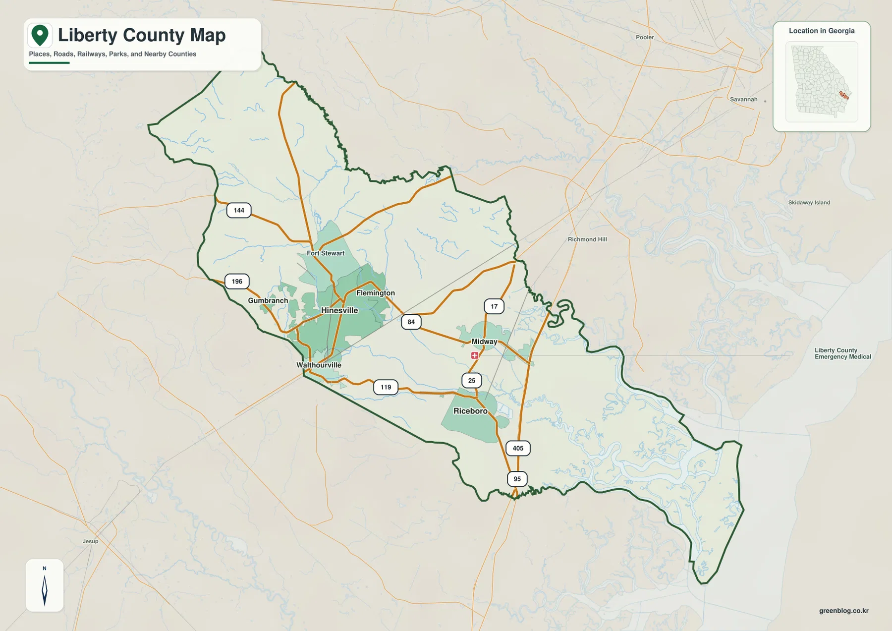
The numbered highways add a second layer of orientation. Route 84 runs from the Hinesville area toward Midway, while 119 crosses the southern part of the populated western half. Labels 144 and 196 appear on the west side, and 17, 25, and 95 are shown farther east in a more north–south arrangement. These labels are useful for understanding where the major places sit in relation to the larger road network, but this is not a turn-by-turn driving map and it does not attempt to show every local street, intersection, or access point. For route planning, the county map should be paired with a current road-navigation source.
The outline also helps explain why the maps look so different from west to east. The county is broad around the Hinesville and Fort Stewart side, then continues southeast into a long coastal section. The background map includes regional labels such as Richmond Hill and Savannah to the northeast and Jesup to the southwest. Those are outside reference points rather than a list of Liberty County communities, but they make the county’s location within southeastern Georgia easier to understand. The county map is therefore most useful when the first question is “where is this place?” rather than “what is the terrain like?” or “which river is this?”
| State | Georgia |
|---|---|
| County seat | Hinesville |
| Prominent places on the maps | Fort Stewart, Hinesville, Flemington, Walthourville, Midway, Riceboro |
| Major water labels | Canoochee River, Jerico River, Medway River, North and South Newport River |
| Elevation note on map | Actual range about -1 to 43 m; mean 10 m |
| Download | ZIP with four high-resolution A3 JPG maps |
A six-city view shows how strongly settlement leans west
The city map strips away much of the road detail and ranks six places with numbered markers. Its CITY INDEX lists Hinesville at 35,679, Walthourville at 3,823, Midway at 2,185, Flemington at 1,571, Allenhurst at 804, and Riceboro at 742. The preview does not state a year for those figures, so they are best treated as the values used by this specific ranked-city graphic rather than as a stand-alone statement about the latest population. Even with that limitation, the scale difference is obvious: Hinesville is visually and numerically separated from the smaller municipalities around it.
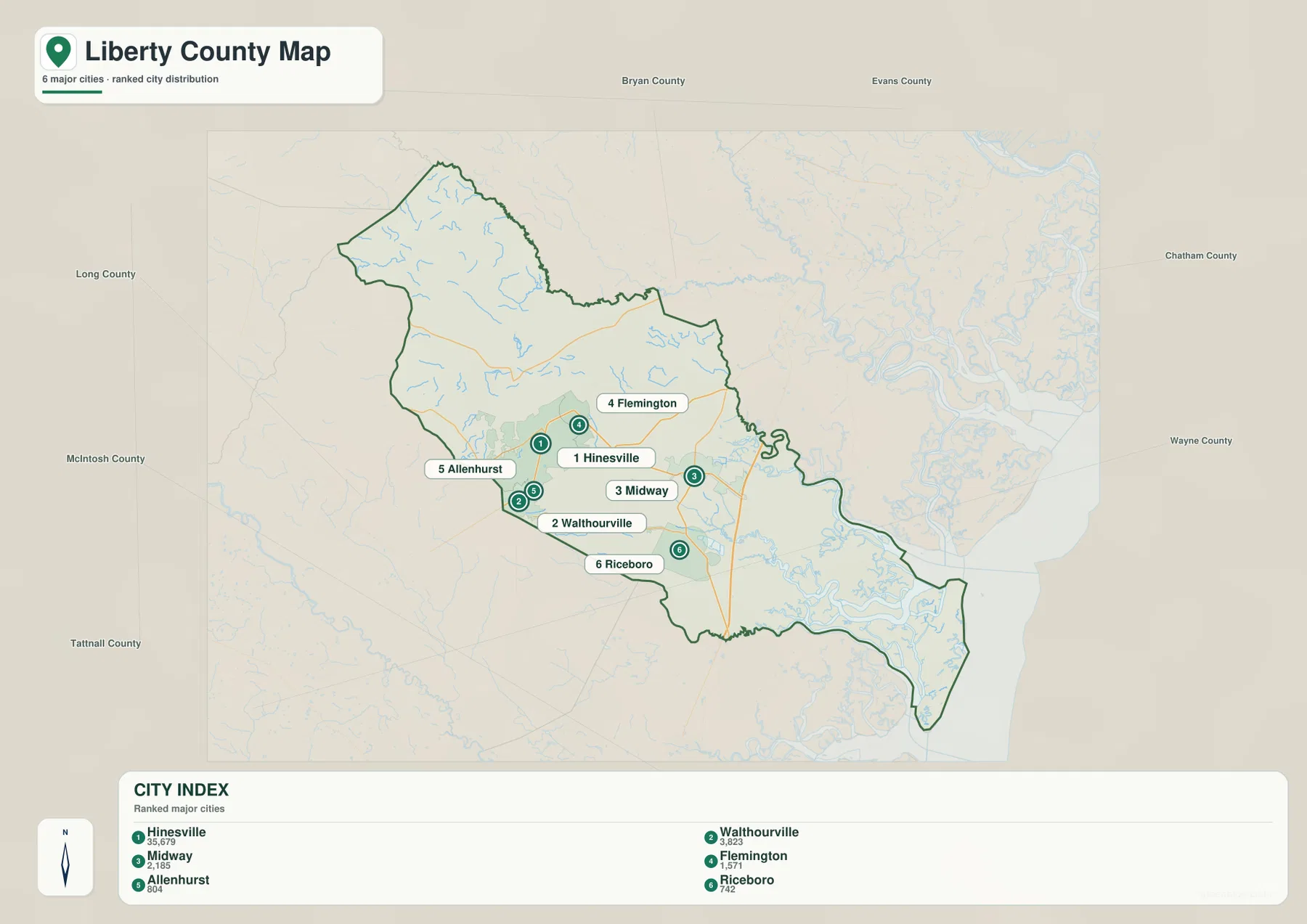
The numbered points also clarify the county’s internal spacing. Hinesville, Flemington, Allenhurst, and Walthourville sit relatively close together in the western center. Midway is distinctly farther east, and Riceboro lies to the southeast. That arrangement matters when the maps are used for a report or classroom reference because it prevents the common assumption that every labeled municipality is separated by a similar distance. The western group is compact, while the two eastern places help bridge the transition toward the water-dominated coastal side.
County names placed outside the outline provide additional orientation. Long County is labeled to the west, Bryan County to the north, Chatham County to the east, and other surrounding county names appear around the frame. These labels should be read as regional context rather than as a precise legal-border diagram. Their main value is helping the viewer understand which direction is inland and which direction leads toward the Atlantic side. In that sense, the city map complements the county reference map: one emphasizes named roads and places, while the other makes the pattern of settlement easier to see at a glance.
Inland creeks expand into a dense coastal water network
The water map changes the visual story of Liberty County almost completely. In the northwest, Canoochee River is the most prominent labeled river, with smaller waterways such as Taylors Creek and Mill Creek nearby. Peacock Creek appears farther toward the middle of the county. South of the Hinesville–Fort Stewart area, Riceboro Creek and Payne Creek are labeled as they run toward the lower and eastern portions of the map. Compared with the city map, there are far more small blue branches than named settlements, which immediately shows how important drainage and coastal waterways are to the county’s physical layout.
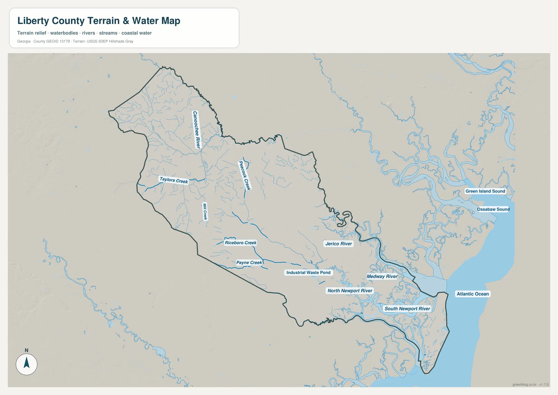
The network becomes markedly more complex toward the east. Jerico River winds along the eastern side of the county, and Medway River occupies the lower-eastern area with broad bends and connected channels. North Newport River and South Newport River appear farther south, surrounded by numerous smaller waterways. Just offshore and to the east of the county, the map labels Green Island Sound, Ossabaw Sound, and the Atlantic Ocean. Those names make the transition from inland drainage to coastal water explicit without requiring the reader to infer where the ocean-facing side lies.
This east–west contrast is important when choosing a landmark. Near Hinesville, a road number or city name usually provides the fastest reference. Near the southeast, the river system is often a more informative visual anchor because the water channels occupy so much of the map. Midway and Riceboro sit in the transition between those two kinds of geography: they are still useful settlement labels, but they are also much closer to the branching river and coastal network than the Hinesville area.
The supplied water map is a reference map of named rivers, creeks, connected channels, and coastal water. It should not be used as a flood-hazard map, a wetland jurisdiction map, a parcel boundary source, or a navigation chart. A blue channel on this map tells the reader that water is mapped there; it does not provide safe boating depth, flood probability, ownership, or legal access information. Those questions require the appropriate current official source.
A low county still has a clear inland-to-coast elevation change
Liberty County is not a mountainous county, yet the elevation map shows a strong internal contrast. The map annotation reports an actual elevation range of about -1 to 43 meters and a mean of 10 meters. Brown and tan tones dominate much of the northwest and western side, indicating the relatively higher ground. Across the middle of the county those colors give way to broad areas of green, and the eastern and southeastern sections are largely represented by the lower end of the local scale.
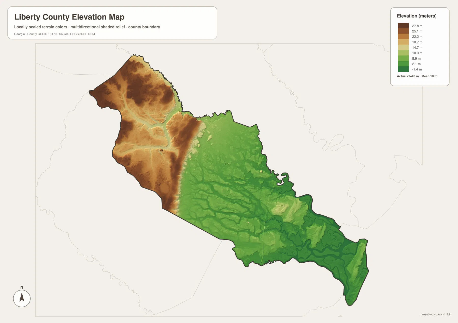
The low eastern colors line up visually with the area where the water map becomes most intricate. Jerico River, Medway River, and the Newport channels occupy terrain that is mostly shown in green. In the northwest, the higher brown surface is cut by lower drainage lines, which keeps the map from looking like a single flat plateau. This relationship between relief and water helps explain why the coastal half has such a different texture from the Hinesville–Fort Stewart side even though the county’s total elevation range is modest.
Because the colors are scaled to highlight variation within Liberty County, they should not be treated as a universal elevation legend for other county maps. The map is also generalized and is not survey-grade. It is useful for comparing broad higher and lower areas, illustrating the transition toward the coast, and placing the river network in terrain context. It is not appropriate for determining a parcel elevation, designing drainage, establishing a construction grade, or evaluating a specific flood risk.
Roads explain the west; water and relief explain the east
Placing the county, water, and elevation maps side by side makes the county’s internal geography much easier to remember. Hinesville and Fort Stewart sit on the inland side where labeled roads form a clear framework. Route 84 points east from the Hinesville area toward Midway, and the other route labels help connect Walthourville, the western edge, and the north–south corridor farther east. The water map then adds a second framework that grows in importance after the settlement cluster thins out.
By the time the viewer reaches the Jerico and Medway river area, the road network is no longer the only useful way to describe position. The dense channels, low terrain, and long southeastern county outline become just as important. That is why a single “Liberty County map” can be technically correct yet still leave out much of what makes the county distinctive. The four-map set separates those functions: roads and named places for orientation, ranked cities for settlement pattern, rivers and sounds for water geography, and a locally scaled relief map for higher-versus-lower terrain.
The Fort Stewart label also helps show why the western side should not be described simply as “urban” while the east is “coastal.” Fort Stewart occupies a large labeled area north of Hinesville, small communities appear around the western and central county, and waterways are present throughout the interior as well. The stronger conclusion supported by the maps is not a hard division but a gradual shift: settlement and road labels dominate the west visually, while channels and very low terrain increasingly dominate toward the east and southeast.
Choose the map that matches the question before downloading the set
For a quick location check, start with the county map. It provides the boundary, Hinesville, Fort Stewart, Midway, Riceboro, Walthourville, Flemington, and the main labeled routes in one view. When the question is specifically about how the municipalities are arranged, the city map is cleaner because the six ranked markers remove much of the other detail. The water map should be the first choice for Canoochee River, Jerico River, Medway River, the Newport rivers, and the coast. The elevation map is the best companion when the goal is to explain why the northwest and the low eastern water country look different.
- County boundary, Hinesville, Fort Stewart, and major route orientation: use the county map first.
- Relative positions of Hinesville, Walthourville, Midway, Flemington, Allenhurst, and Riceboro: use the city map.
- Canoochee River, Jerico River, Medway River, Newport River channels, sounds, and Atlantic context: use the water map.
- Broad higher-versus-lower terrain from the northwest to the coast: use the elevation map.
- Printing, offline study, or high-resolution viewing: download the ZIP containing all four A3 JPG originals.
The page previews use WebP so the maps can be viewed efficiently in a browser. The archive linked below contains the four original A3 high-resolution JPG versions instead. Keeping all four files together is useful when a project needs more than one geographic layer—for example, a report may use the county map to establish location and the water or elevation map to explain the physical setting. The files remain general reference maps, so legal boundaries, engineering elevations, flood hazards, and navigation decisions should always be checked against the appropriate current authoritative data.
Frequently Asked Questions
Why does the eastern side of the Liberty County water map look so much more complex?
The east and southeast contain the Jerico River, Medway River, North Newport River, South Newport River, and many smaller connected channels. The map also shows Green Island Sound, Ossabaw Sound, and the Atlantic Ocean to the east. That concentration of waterways creates a much denser blue network than the inland side. The map shows water locations only; it is not a flood-risk or navigation product.
Which map is best for locating Hinesville and Fort Stewart?
Start with the county map. Hinesville is labeled in the west-central portion of Liberty County and Fort Stewart appears immediately to the north, with Route 84 and nearby communities providing additional orientation. The city map is a useful second view when the goal is to compare Hinesville with Walthourville, Flemington, Allenhurst, Midway, and Riceboro.
Can the elevation map be used to determine flood risk or a construction elevation?
No. The supplied elevation map is a generalized county reference that highlights broad differences and reports an actual range of about -1 to 43 meters with a mean of 10 meters. It is not survey-grade and does not replace parcel-level elevation, engineering, drainage, or official flood-hazard data.
Sources and Reference Data
The article is grounded in the supplied Liberty County map set and the existing county-page material. The following official or established resources are useful for checking county information, population data, boundaries, hydrography, and elevation in more detail.
- Liberty County government
- U.S. Census Bureau QuickFacts — Liberty County, Georgia
- New Georgia Encyclopedia — Liberty County
- U.S. Census Bureau TIGER/Line Shapefiles
- USGS National Hydrography
- USGS 3D Elevation Program
Map File Information
The WebP images on this page are lightweight previews. The downloadable ZIP contains four original high-resolution A3 JPG files for printing, saving, or detailed reference.
- File Type: ZIP containing four high-resolution A3 JPG files
Related Maps
Green Map creates custom-edited map images using open geographic data sources such as geoBoundaries, Natural Earth, OpenStreetMap, and government open data. These maps are edited visual materials, not raw data files, and are provided for education, documents, presentations, and graphic reference.