Doniphan County occupies the northeastern corner of Kansas, where the Missouri River wraps around much of the northern and eastern boundary. Troy provides a useful central reference, Wathena and Elwood sit close to the river on the east, Highland and White Cloud lie in the northwest, and Severance and Denton mark the western side. U.S. 36, K-7, K-20, and K-120 help organize these places on the general map. High-resolution JPG files corresponding to the supplied web maps can be downloaded together from the ZIP box later on this page. High-resolution map files are available for download in the section below.
The county’s relief is pronounced for northeastern Kansas. The elevation surface ranges from about 238 to 366 meters, with a mean near 300 meters. Green lowlands follow the Missouri River and the larger interior streams, while yellow, tan, and brown ridges occupy much of the western and central uplands. Wolf River, Cedar Creek, Mill Creek, Peters Creek, Rock Creek, and many smaller tributaries cut through those uplands and create the tightly dissected terrain visible on the shaded-relief map.
The Kansas Historical Society places Doniphan County in the Glaciated Region and notes the Glacial Hills Scenic Byway. The county’s tourism material also emphasizes Missouri River views, rolling farmland, bluffs, and the Glacial Hills landscape. Those descriptions fit the map set well: the river forms an unusually curved county edge, and the interior is divided into repeated ridges and creek valleys rather than broad flat plains.
Table of Contents
Troy and U.S. 36 as the first orientation points
Troy is close to the center of the county and works well as the first place to locate on the general map. U.S. 36 approaches from the east through the Wathena and Elwood area before continuing toward Troy and the western road network. K-7 runs north and south through the central portion and continues toward Atchison outside the county. K-20 and K-120 provide additional reference points around Denton and Severance on the west side.
White Cloud sits near the Missouri River at the northwestern tip, while Highland lies farther inland to the south. Leona, Severance, Denton, and Bendena are distributed across the western half, where the road grid crosses rolling terrain and many small streams. By contrast, Wathena and Elwood occupy a much tighter area near the eastern river bends. This split between river-edge communities and inland upland settlements is one of the easiest patterns to recognize on the county map.
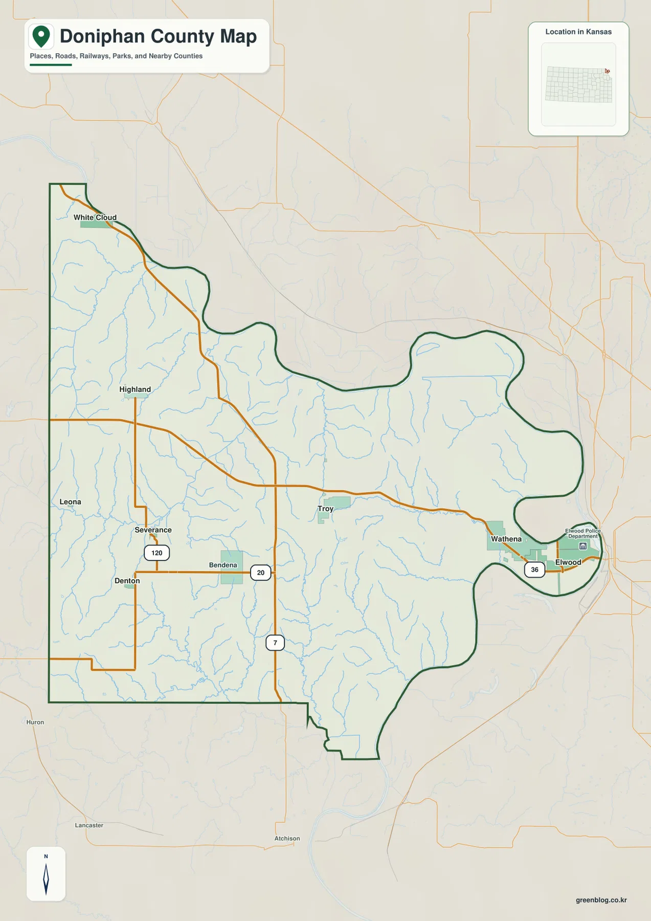
The shape of Doniphan County is itself an important geographic clue. The Missouri River creates broad curves along the north and east instead of the straight borders common to many Kansas counties. Elwood and Wathena are close to those river bends, while Troy, Highland, and the western communities sit deeper in the uplands. The map is intended for county-scale orientation rather than live navigation, so current closures, construction, and travel conditions should be checked with up-to-date road information.
How Wathena, Highland, Elwood, and Troy are distributed
The city distribution map simplifies the background and ranks six major communities. Wathena appears first in the city index, followed by Highland and Elwood, while Troy is fourth even though it is the county seat. White Cloud and Denton are much smaller in the map’s city index. This is a useful reminder that administrative importance and population ranking do not always point to the same place.
Spatially, Wathena and Elwood are grouped near the eastern Missouri River corridor. Troy lies west of them in the central part of the county, Highland is farther northwest, White Cloud is near the river at the northern tip, and Denton lies in the southwest. The result is a dispersed settlement pattern with separate river and upland centers rather than one continuous urban strip.
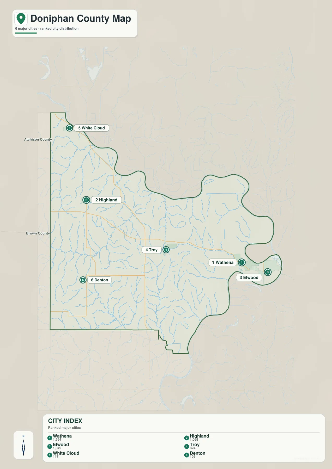
The Kansas Historical Society identifies Troy as the county seat, and the county’s tourism pages highlight the courthouse and other historic resources there. That makes Troy a strong administrative and geographic anchor even though Wathena, Highland, and Elwood rank higher in the supplied city index. For travel planning, the distribution map should be paired with the general road map because the city symbols do not show the full set of routes between communities.
Missouri River bends and the interior creek network
The terrain and water map is dominated by the Missouri River. It curves around the northern and eastern sides of the county and forms broad lowlands near White Cloud, Wathena, and Elwood. The river’s sweeping boundary explains why Doniphan County has a much more irregular outline than the rectangular counties farther west in Kansas. The contrast between the river bottom and the adjacent bluffs is also clearly visible in the terrain shading.
Inland, Wolf River crosses the northwestern and central area and is joined by or associated with a dense network of smaller creeks. Cedar Creek and Mill Creek mark the northwest, while Mosquito Creek and Peters Creek drain toward the east. Farther south, Walnut Creek, Brush Creek, Rock Creek, Jordan Creek, and branches of Independence Creek cut into the uplands. The many narrow valleys divide the county into ridges that are much more apparent on the water and elevation maps than on the road map.
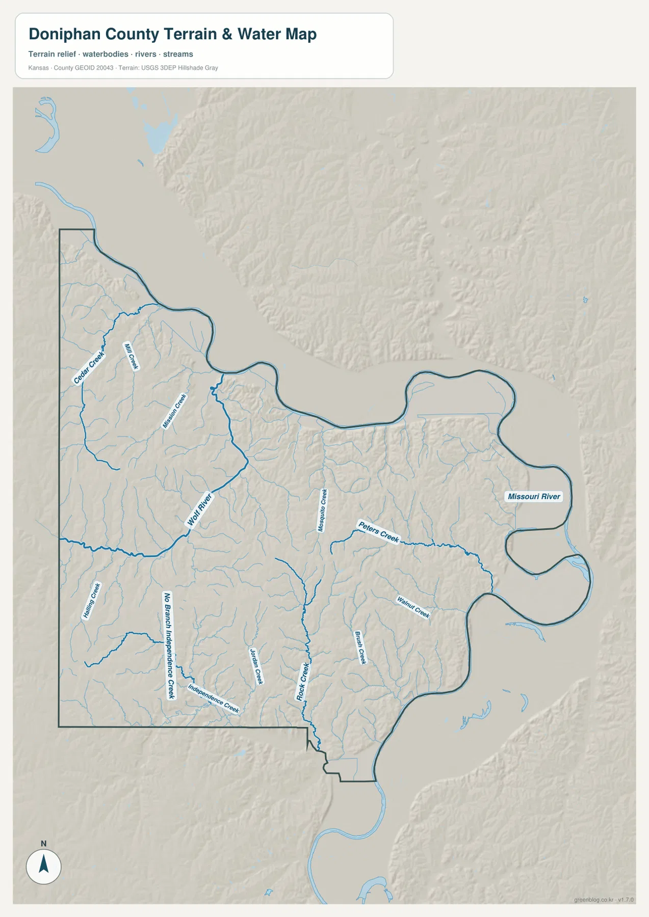
This map is a geographic reference for stream location and terrain context. It is not a live flood map, stream-gauge display, water-quality product, or navigation chart. Current Missouri River stages or local creek conditions should be checked with USGS or the appropriate local authority. For this page, the most useful comparison is between the low river corridors and the higher ridges separating the tributaries.
From 238-meter river bottoms to 366-meter uplands
The elevation map shows an actual range of roughly 238 to 366 meters and a mean elevation of about 300 meters. The lowest green colors follow the Missouri River and several of the major interior drainage corridors. Yellow and tan uplands occupy broad areas away from the river, while darker brown ridges appear across the western and central parts of the county.
The relief is especially clear where the Missouri River lowland meets the interior hills. Elevation rises quickly from the river edge into a heavily dissected landscape, and small tributaries create narrow green lines between higher ridges. Similar patterns appear around Wolf River and Rock Creek. Rather than a landscape dominated by one mountain or escarpment, Doniphan County consists of many closely spaced hills and valleys.
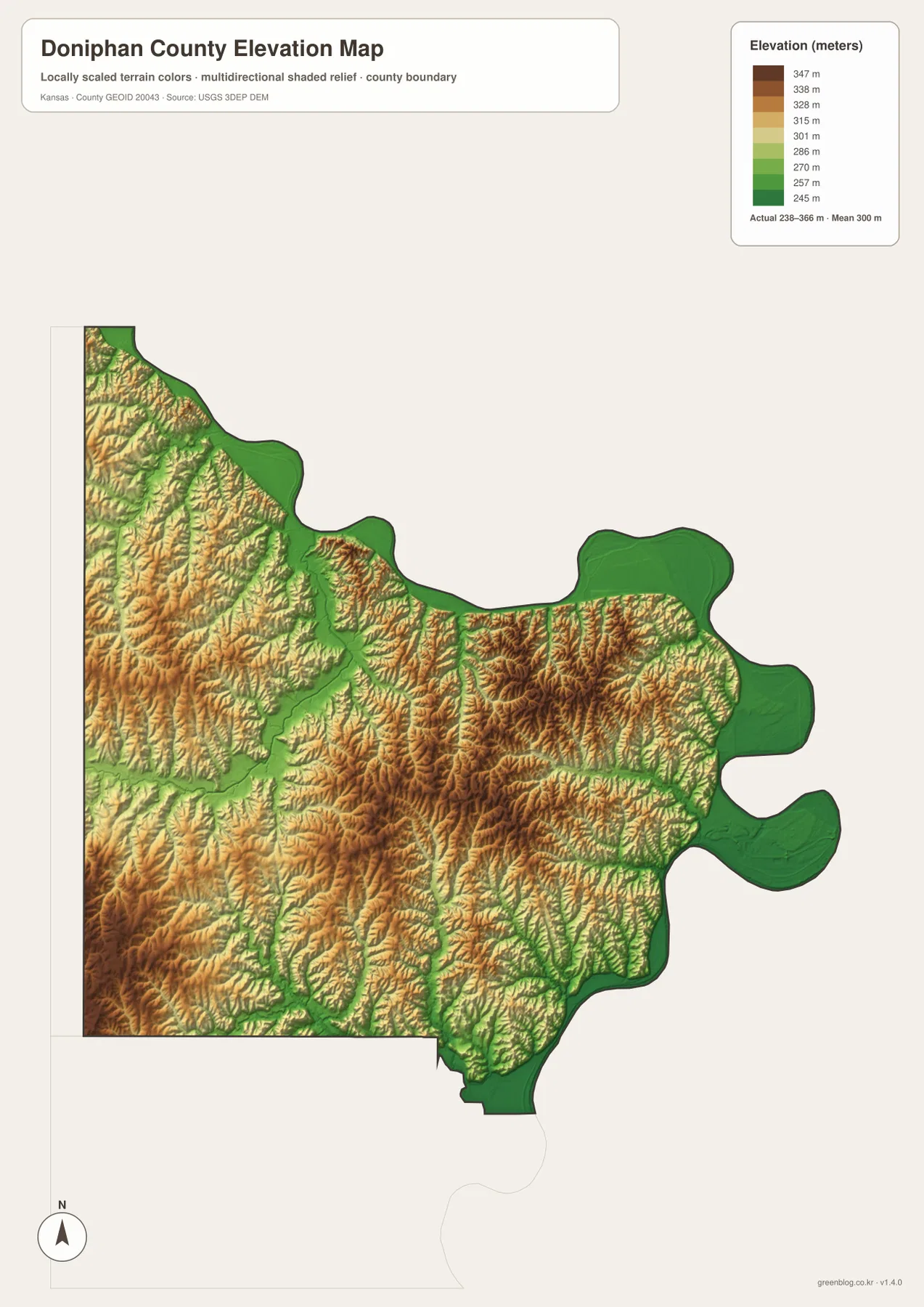
The elevation surface is intended for broad geographic comparison and should not be treated as survey-grade measurement. Exact parcel elevations, construction design, drainage engineering, or legal surveys require purpose-built data and professional methods. For regional understanding, however, the map clearly explains why Wathena and Elwood occupy low river-edge terrain while Troy, Highland, and much of the western interior sit among higher rolling hills.
Glacial Hills, bluffs, and northeastern Kansas character
The Kansas Historical Society classifies Doniphan County within the Glaciated Region and lists the Glacial Hills Scenic Byway. County tourism material likewise highlights rolling farmland, Missouri River views, bluffs, and the Glacial Hills. The supplied maps make these labels easier to understand because the interior is shown as a dense mosaic of ridges, ravines, and creek valleys rather than a smooth plain.
White Cloud is especially close to the Missouri River at the northern end of the county, where the river and adjacent high ground create a strong landscape contrast. Highland lies farther inland among the hills. Moving east from Troy toward Wathena and Elwood brings the map reader toward the broad Missouri River lowland, while travel west leads into the Wolf River drainage and the more extensive upland network.
The county’s history is also tied to this border location. The Kansas Historical Society notes that Doniphan County was established in 1855 as one of the early Kansas counties and identifies Troy as the county seat. Its position beside Missouri and Nebraska, its long settlement history, and its historic routes and institutions help explain why several small communities remain important geographic markers despite the county’s modest population.
Choosing the right map for study, travel context, or printing
For basic orientation, begin with the general map and locate Troy, U.S. 36, and K-7. Add Wathena and Elwood along the eastern river corridor, then Highland and White Cloud in the northwest. This framework is useful for school assignments, regional introductions, local-history material, and trip preparation because it establishes the settlement and road pattern before terrain detail is added.
For physical geography, start with the Missouri River and follow Wolf River, Cedar Creek, Peters Creek, and Rock Creek into the interior. The elevation map then shows how those waterways occupy lower green corridors between higher hills. When discussing a particular town, switching between the city distribution map and the terrain maps connects the human settlement pattern with the landforms that surround it.
For printing or placement in a larger document, the high-resolution JPG files in the ZIP are preferable to reduced web previews. They preserve labels and terrain detail at a size better suited to enlarged viewing. Anyone republishing or modifying the maps should check the relevant source and attribution requirements. Projects that depend on current road status, live river conditions, flood hazards, or exact elevations should use the latest authoritative data in addition to these reference maps.
Frequently Asked Questions
Where is Troy on the Doniphan County map?
Troy lies near the center of the county and is easy to locate from U.S. 36 and K-7. The Kansas Historical Society identifies Troy as the county seat. Wathena and Elwood lie to the east near the Missouri River, while Highland and White Cloud are northwest of Troy, making the city a convenient first reference for the rest of the county.
How does the Missouri River shape Doniphan County?
The Missouri River wraps around much of the county’s northern and eastern edge and forms a large part of its natural boundary. The elevation map shows the river corridor as some of the county’s lowest terrain, with the land rising rapidly into interior hills. The water map shows geographic relationships only; it does not provide live flood stages or current river conditions.
Can the 238–366 meter elevation map be used for surveying or engineering?
No. The elevation map is a county-scale reference for comparing river bottoms, ridges, and creek valleys. Exact parcel elevations, construction design, drainage engineering, and legal surveys require purpose-built data and professional methods appropriate to those tasks.
Map File Information
Download the high-resolution JPG files corresponding to the Doniphan County general, city distribution, terrain-and-water, and elevation maps in one ZIP archive.
- Included Files: Use only the versions confirmed in the article and supplied images
- File Type: Use the confirmed download contents
- Intended Use: Printing, education, presentations, and map-based projects
Related Maps
Sources and references
- Doniphan County, Kansas official website — county government and local information
- Doniphan County Tourist Attractions — Glacial Hills, Missouri River views, and local landmarks
- Kansas Historical Society — Doniphan County, Kansas — county seat, history, and Glaciated Region context
- U.S. Census Bureau TIGER/Line — boundary and geographic data resources
- USGS National Hydrography — hydrography and stream-network data information
- USGS 3D Elevation Program — elevation data information
Green Map creates custom-edited map images using open geographic data sources such as geoBoundaries, Natural Earth, OpenStreetMap, and government open data.
These maps are edited visual materials, not raw data files, and are provided for education, documents, presentations, and graphic reference.