Douglas County sits in northeastern Kansas, with Lawrence serving as the clearest anchor for roads, settlements, rivers, lakes, and terrain. Lawrence is the county seat and the largest urban center on the supplied map, while Eudora lies to the east, Baldwin City to the south, and Lecompton to the northwest. U.S. 40 and U.S. 59, K-10, and the I-70 corridor make Lawrence easy to locate before smaller roads are considered. High-resolution JPG files corresponding to the web maps can be downloaded together from the ZIP box later on this page. High-resolution map files are available for download in the section below.
Natural features create a second framework for understanding the county. The Kansas River bends along the northern side, while the Wakarusa River crosses the middle of the county from Clinton Lake toward the east. The elevation surface ranges from roughly 236 to 365 meters, with a mean of about 296 meters. Lower green terrain follows the Kansas and Wakarusa river corridors, whereas higher rolling ground is much more common in the northwest and across the southern half.
The Kansas Historical Society identifies Lawrence as the county seat and places Douglas County in both the Glaciated Region and the Osage Cuestas. Those regional descriptions fit the supplied terrain map: the county contains broad river lowlands as well as strongly dissected hills and ridges. Reading the roads, settlement locations, waterways, and relief together makes it easier to understand why Lawrence is such a dominant reference point while the surrounding countryside changes quickly outside the city.
Table of Contents
Lawrence as the road anchor between the Kansas and Wakarusa rivers
The general county map makes Lawrence the obvious first stop. U.S. 40 and U.S. 59 pass through or near the city, K-10 extends east toward Eudora, and the I-70 corridor lies along the northern side near the Kansas River. Lecompton sits northwest of Lawrence close to the river, while Eudora occupies the eastern part of the county. These roads and place names create a simple framework before the dense network of local roads and streams is added.
South of Lawrence, U.S. 59 provides a strong directional reference toward Baldwin City. The southern half contains fewer large settlement labels and more county roads, creeks, and rolling terrain. K-200 is visible near Baldwin City, while other numbered roads connect smaller rural areas. The general map is designed for county-scale orientation rather than live navigation, so current construction, closures, and travel conditions should be checked with up-to-date transportation information.
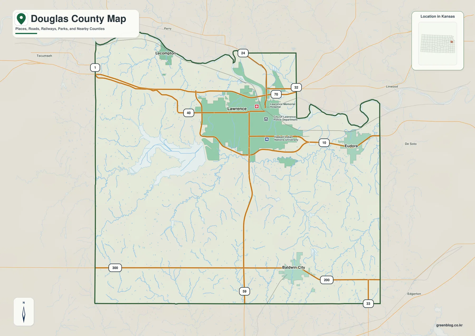
The contrast between Lawrence and the rest of the county is easy to see. Lawrence contains the largest continuous urban area and the densest road pattern, while western and southern Douglas County are dominated by rural roads, tributaries, and open space. Clinton Lake and the Wakarusa valley also influence the route pattern west and south of the city, where roads bend around water and more broken terrain. This makes the county useful for comparing an urban center with a surrounding rural landscape on the same map.
Eudora, Baldwin City, and Lecompton around the Lawrence hub
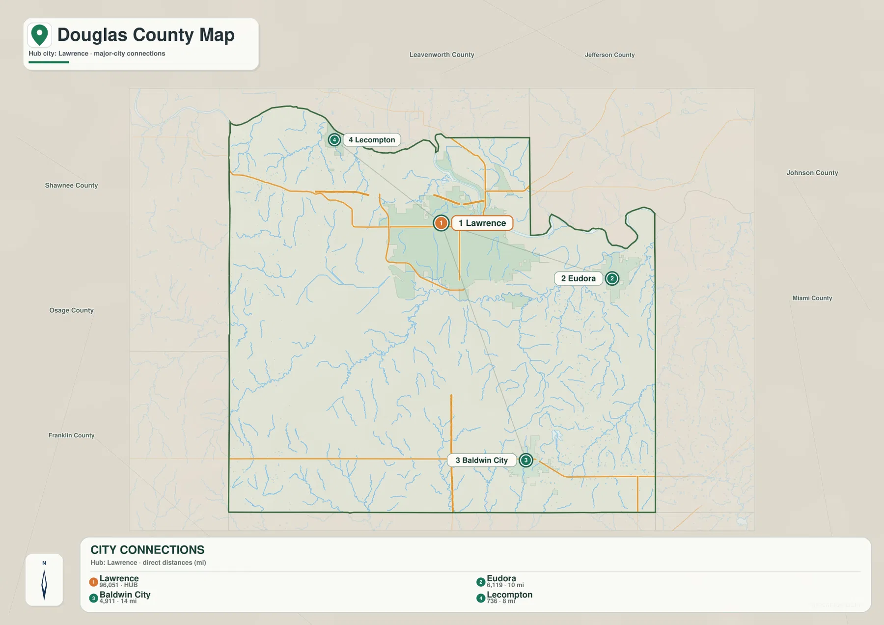
The city connection map simplifies the county to four prominent settlements. Lawrence is marked as the hub, with Eudora about 10 miles to the east, Baldwin City about 14 miles to the south, and Lecompton about 8 miles to the northwest. The distances shown are straight-line references intended to communicate scale and direction. They should not be treated as current driving mileage, because road routes and actual travel distances differ.
This arrangement shows how the county’s principal communities spread in different directions from Lawrence rather than forming one continuous urban corridor. Eudora lies near the eastern edge and the K-10 route, Baldwin City provides a southern anchor, and Lecompton occupies a smaller settlement position near the Kansas River. Once these points are fixed in mind, the general map becomes easier to read because smaller roads and waterways can be related back to a familiar city.
Lecompton also has unusual historical importance for a small community. The Kansas Historical Society notes that it served as the capital of Kansas Territory and was the setting for the Lecompton Constitution controversy. That history gives its location near the Kansas River and northwest of Lawrence added context. Baldwin City, by contrast, works especially well as a reference for the higher southern terrain and the smaller creek systems that drain that part of Douglas County.
Kansas River lowlands, Clinton Lake, and the Wakarusa corridor
The terrain and water map is dominated by two major river systems. The Kansas River follows the northern edge in a broad low corridor, passing north of Lawrence and continuing toward the east. Coon Creek drains part of the northwestern uplands toward the river, and Lake View Lake is labeled south of the main channel. The surrounding shaded relief is much lower and smoother near the river than on the hills farther west.
Across the middle of the county, the Wakarusa River flows eastward from the Clinton Lake area and continues south of Lawrence toward the eastern side. Clinton Lake is the largest mapped water body and sits in a broad valley fed by Washington Creek and numerous smaller tributaries. Farther east, Coal Creek, Spring Creek, Little Wakarusa River, and Little Wakarusa Creek create additional branching valleys. Captain Creek appears in the southeast, extending the network into the higher southern terrain.
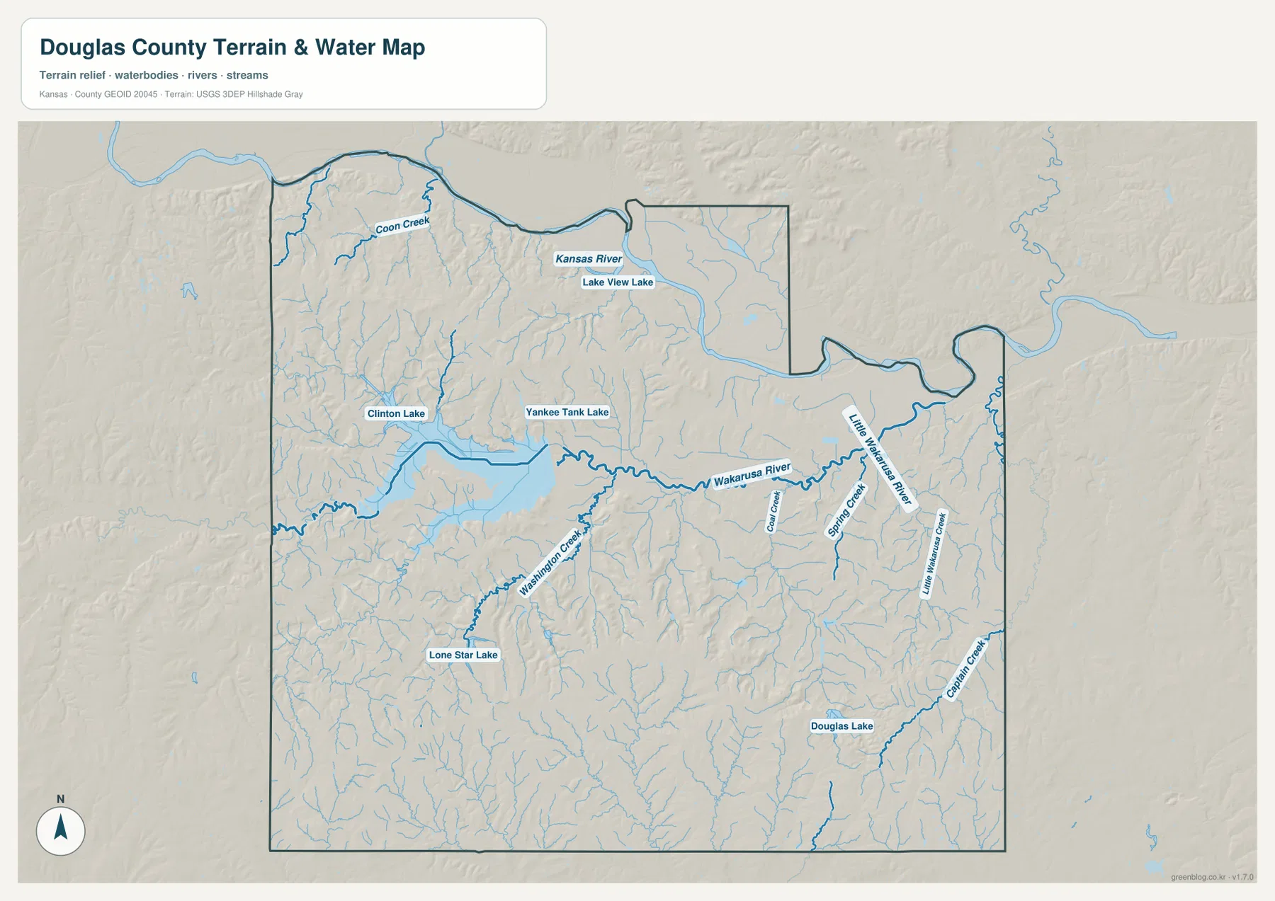
Other labeled lakes add useful local reference points. Lone Star Lake appears in the southwest and Douglas Lake in the southeast, while Yankee Tank Lake is shown near the central portion of the county. These features demonstrate that the county’s water landscape is not limited to the two large rivers. The map is a geographic reference, not a live flood, water-level, or water-quality product; current conditions require observations from USGS or other responsible agencies.
A 236–365 meter elevation range across river valleys and rolling hills
The elevation map gives Douglas County an actual range of approximately 236 to 365 meters and a mean of about 296 meters. The Kansas River corridor across the north and the Wakarusa River corridor through the central-eastern part of the county appear in darker green, marking the lowest broad areas. Clinton Lake occupies the same central lowland system. Higher tan and brown terrain becomes much more common in the northwest and across the southern half.
The northwest is strongly dissected by many small valleys, producing a dense pattern of ridges. Southern Douglas County also contains extensive higher ground, with narrow tributary valleys cutting through the uplands around and west of Baldwin City. The central Wakarusa valley forms a noticeable lower band between these higher regions. Near Eudora, the lower terrain associated with the Kansas and Wakarusa systems becomes especially broad.
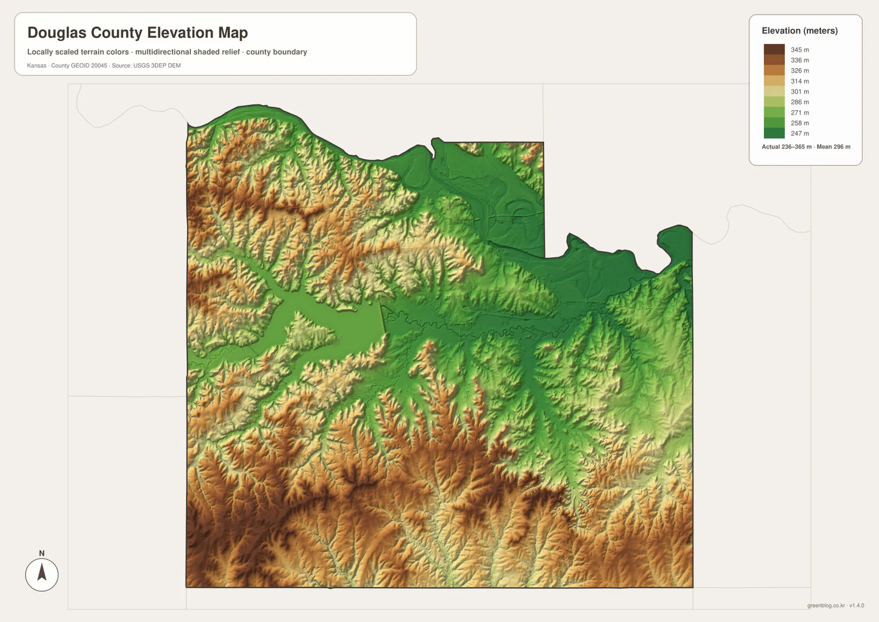
This elevation surface is intended for county-scale comparison rather than survey-grade measurement. It should not be used to establish an exact parcel elevation, design drainage, or replace engineering or legal survey data. Its value is visual context: the map makes it easy to see why rivers and lakes occupy broad green corridors and why local roads outside Lawrence cross much more broken terrain.
Glaciated Region and Osage Cuestas in one county
The Kansas Historical Society describes Douglas County as spanning the Glaciated Region and Osage Cuestas. The supplied elevation and water maps show why more than one regional landscape applies. Northern river country includes broad lowlands and rolling dissected hills, while the southern half contains long ridges and repeated creek valleys. The transition is gradual rather than a sharp line drawn across the county.
Moving from Lawrence toward the Kansas River generally brings the landscape into lower terrain. Traveling west or south leads into more rolling ground, and the higher colors become more extensive around the southern and northwestern parts of the county. The Wakarusa River interrupts that pattern with a lower central corridor, and Clinton Lake occupies a large portion of the same valley system. This combination gives Douglas County a much more varied surface than the urban map of Lawrence alone might suggest.
Lawrence therefore provides only one part of the county story. The city is the main administrative and transportation center, but a short move beyond its developed area reaches Clinton Lake, wooded stream valleys, rural roads, and higher ridges. Combining settlement and terrain information is especially useful for local-history projects, outdoor planning, and regional comparisons because it prevents the county from being reduced to its largest city.
Choosing the right view for orientation, terrain, or printing
For basic orientation, start with the general map and locate Lawrence at the county’s main road network. Add Eudora to the east, Baldwin City to the south, and Lecompton to the northwest. The city connection map is useful when the goal is simply to compare those settlement positions and approximate straight-line distances without the distraction of every local road.
For physical geography, follow the Kansas River along the north and the Wakarusa River from Clinton Lake toward the east. The terrain and water map shows the tributaries that feed those corridors, while the elevation view reveals how strongly the surrounding land rises away from them. This is particularly clear in northwestern and southern Douglas County, where many small valleys cut into higher ground.
For printing or inclusion in a larger document, the high-resolution JPG files in the ZIP are preferable to the reduced web previews. They preserve labels and terrain detail at a size better suited to enlarged viewing. Anyone republishing or modifying the maps should check applicable source and attribution requirements. Projects that depend on current roads, flood conditions, exact property boundaries, or precise elevations should pair these reference maps with the latest authoritative data.
Frequently Asked Questions
Where is Lawrence on the Douglas County map?
Lawrence is in the north-central part of Douglas County near the main U.S. 40, U.S. 59, K-10, and I-70 corridor. The Kansas Historical Society identifies Lawrence as the county seat. Eudora lies to the east, Baldwin City to the south, and Lecompton to the northwest, making Lawrence the most useful first reference for locating the county’s principal communities.
How are Clinton Lake and the Wakarusa River connected?
Clinton Lake occupies a large valley in west-central Douglas County and belongs to the Wakarusa River system. The Wakarusa continues eastward from the lake area, passing south of Lawrence toward Eudora. The terrain and water map shows this geographic relationship, but it is not a real-time source for lake level, flood risk, or streamflow.
Can the 236–365 meter elevation map be used for surveying?
No. The elevation map is a county-scale visual reference for comparing river lowlands, ridges, and hills. Exact parcel elevations, construction design, drainage engineering, and legal surveys require purpose-built data and professional methods appropriate to those tasks.
Map File Information
Download the high-resolution JPG files corresponding to the Douglas County general, city connection, terrain-and-water, and elevation maps in one ZIP archive.
- Included Files: Use only the versions confirmed in the article and supplied images
- File Type: Use the confirmed download contents
- Intended Use: Printing, education, presentations, and map-based projects
Related Maps
Sources and references
- Kansas Historical Society — Douglas County, Kansas — county seat, historical context, and physiographic regions
- U.S. Census Bureau TIGER/Line — boundary and geographic data resources
- USGS National Hydrography — hydrography and stream-network data information
- USGS 3D Elevation Program — elevation data information
Green Map creates custom-edited map images using open geographic data sources such as geoBoundaries, Natural Earth, OpenStreetMap, and government open data.
These maps are edited visual materials, not raw data files, and are provided for education, documents, presentations, and graphic reference.