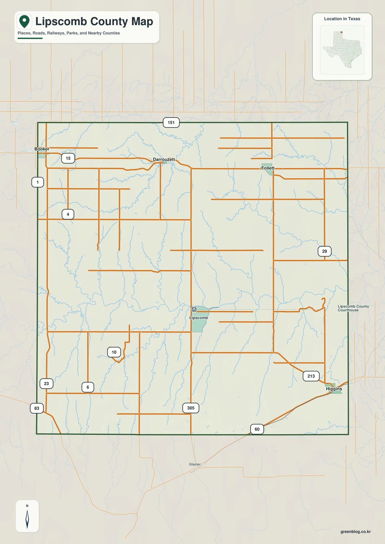
You can download four high-resolution A3 JPG maps of Lipscomb County, Texas, in one ZIP directly from this page. The set includes a general county map, a ranked city map, a terrain-and-water map, and an elevation map. Together they show Booker, Higgins, Follett, Darrouzett, Lipscomb, numbered roads across the county, the Kiowa and Wolf Creek systems, and an actual elevation range of about 678 to 883 meters.
The county is easiest to understand by comparing the northern line of towns with the more isolated communities farther south. Booker, Darrouzett, and Follett sit across the north near the road marked 15, while Higgins occupies the southeastern corner near Route 60. Lipscomb, the county-seat reference on the general map, is much farther south than the northern town line and closer to the center of the county. The water and elevation maps explain what fills the broad spaces between these settlements: deeply cut creek valleys inside otherwise higher plains.
Table of Contents
Booker, Darrouzett, and Follett form the clearest northern town line
Booker is near the northwestern corner and is the first strong settlement label on the general map. The road marked 15 runs east from the Booker area through Darrouzett and toward Follett, making the northern part of Lipscomb County unusually easy to orient. Road numbers 1, 4, 23, and 83 appear along or near the western side, while 151 is labeled across the northern boundary.
Darrouzett lies between Booker and Follett and provides a useful midpoint for the northern corridor. Follett is farther east, close to the northeastern side of the county. The town labels are relatively close together compared with the long distances south of them, so the north looks much more settlement-dense than the county interior.
Lipscomb and Higgins occupy a different part of the county than the northern towns
Lipscomb is labeled near the center-south portion of the county and includes a courthouse symbol on the general map. Its position is well south of Booker, Darrouzett, and Follett. Route 305 appears below the Lipscomb area, while a network of local roads crosses the broad interior around the county-seat location.
Higgins sits near the southeastern corner. Route 60 runs east-west through the Higgins area, and 213 approaches from the northwest. This creates a southern transportation reference that is separate from Route 15 in the north. The overall road pattern therefore looks less like one continuous town corridor and more like two settlement zones separated by a large creek-cut interior.
The ranked city map puts Booker first and Higgins second
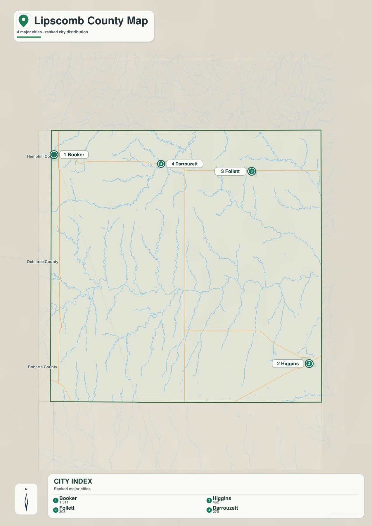
The city index ranks four major communities. Booker is number 1 with 1,311 shown in the index, Higgins is number 2 with 462, Follett is number 3 with 305, and Darrouzett is number 4 with 270. These values are presented as part of the supplied city map, and the ranking is most useful as a compact way to distinguish the four communities.
The positions matter as much as the numbers. Booker, Darrouzett, and Follett line the northern portion, while Higgins is isolated in the southeast. Lipscomb is visible on the general county map as the county-seat location but is not included in this four-city ranking. Comparing the two maps therefore makes the difference between the administrative reference point and the largest mapped communities very clear.
Hemphill County, Ochiltree County, and Roberts County are labeled outside the western side for regional orientation. The ranked city map is useful when settlement distribution is the main question. The general map is better when the road numbers, the county-seat label, and additional local connections are needed.
Kiowa Creek in the north and Wolf Creek across the middle shape the water map
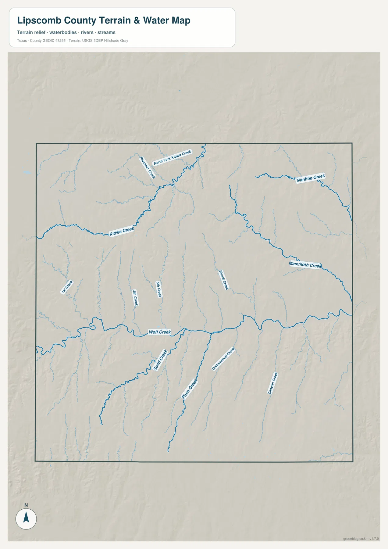
The terrain-and-water map gives the county a much more rugged appearance than the road map. Kiowa Creek enters from the west across the northern half and bends toward North Fork Kiowa Creek. First Creek is labeled nearby, while Ivanhoe Creek occupies a separate northeastern drainage. These channels create deep, branching valleys under the relatively straight road pattern shown on the general map.
Wolf Creek is the strongest central water reference. It runs broadly west to east across the middle of the county, with multiple smaller channels joining it from both sides. Sand Creek approaches from the south, and several numbered or smaller creeks descend toward the same central valley. The result is a long drainage corridor that divides the higher northern and southern surfaces.
Farther south, Plum Creek and Colorado Creek run northward through separate valleys, while Canyon Creek is labeled toward the southeast. Mammoth Creek forms a prominent eastern channel north of Wolf Creek. The map is designed to show the relative positions of creeks and tributaries; it should not be used as a flood-hazard, parcel-boundary, legal-water-boundary, or navigation product.
Higher western plains descend into broad eastern and central creek valleys
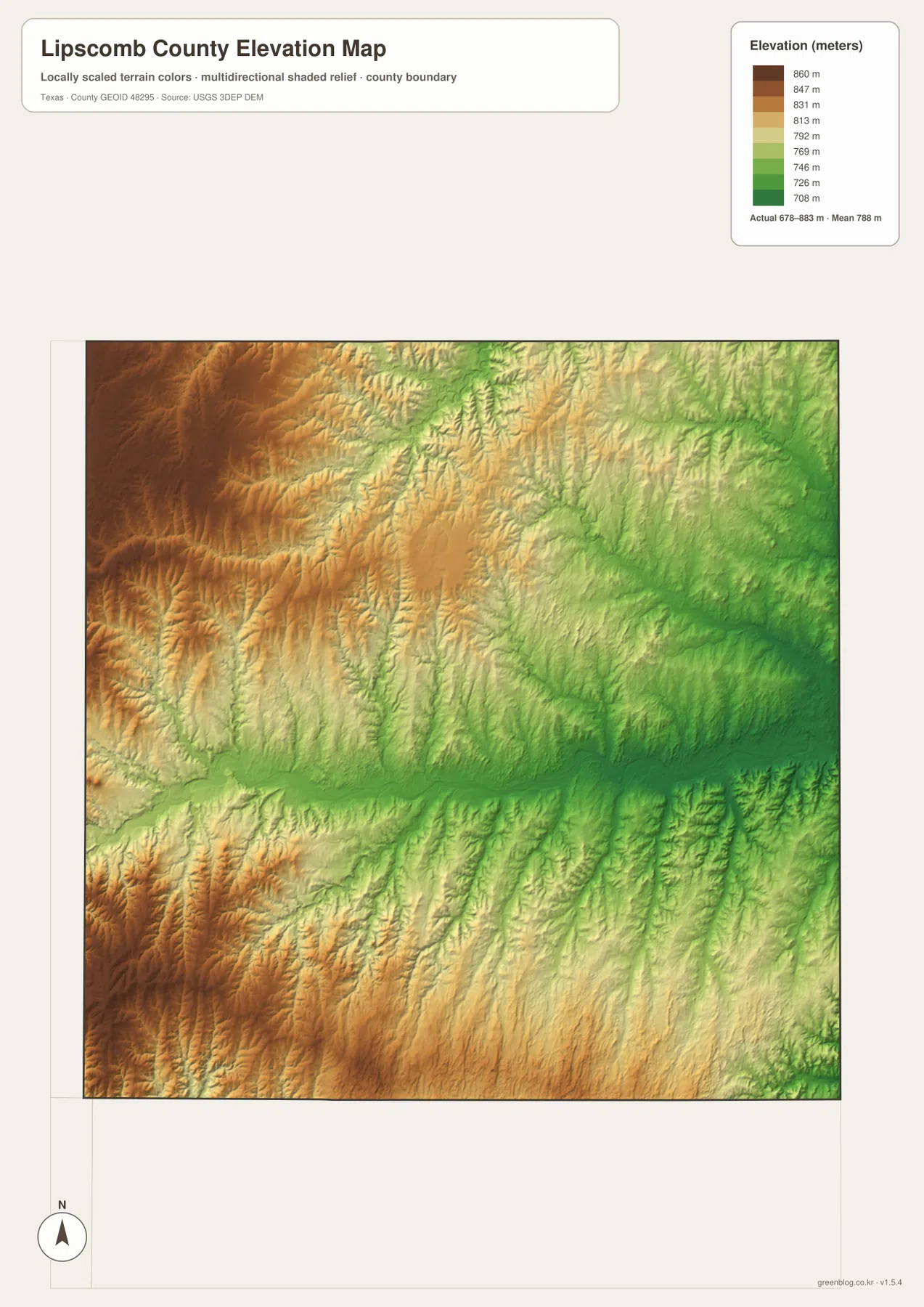
The elevation map reports an actual range of about 678 to 883 meters and a mean elevation of about 788 meters. Brown and dark tan terrain is concentrated in the west and northwest, with another elevated area in the southwest. Greens become more extensive toward the center and east, especially along the long creek valleys.
The broad central low band closely follows Wolf Creek. Kiowa Creek creates another deeply incised northern valley, while Mammoth Creek and Ivanhoe Creek occupy greener lower terrain farther east. The western uplands are not a flat table: numerous tributaries cut narrow grooves into the higher surface, producing a strongly textured shaded-relief pattern.
The difference between the displayed minimum and maximum elevation is about 205 meters. That amount of relief is substantial enough for the creek valleys to stand out clearly even though the county is part of a broad plains region rather than a mountain range. The map is best used for comparing relative terrain and drainage, not as survey-grade or engineering-grade elevation measurement.
Matching towns with creek valleys explains why the county does not look uniformly flat
The Booker-to-Follett corridor is a useful example. The general map shows a relatively straight road line across the north, but the water map reveals Kiowa Creek and North Fork Kiowa Creek cutting through the same broad area. On the elevation map, those channels appear as lower green valleys inside higher surrounding terrain. The road and relief maps therefore describe two different aspects of the same northern landscape.
The central and southeastern parts offer another contrast. Lipscomb and Higgins are widely separated on the road map, with few large settlement labels between them. The water map fills that space with Wolf Creek and several southern tributaries, and the elevation layer shows a broad low corridor through the middle. The open interior is therefore not an empty flat surface; it contains a dense network of incised drainage.
Use the ranked city map when the four major communities are the focus, the general map when roads and the county-seat location are needed, the terrain-and-water map for creek names, and the elevation map for the west-to-east relief contrast. Smaller labels are often easier to inspect in the downloadable high-resolution JPG files than in the web previews.
Frequently Asked Questions
Which communities are ranked on the Lipscomb County city map?
The map ranks Booker first, Higgins second, Follett third, and Darrouzett fourth. Booker, Darrouzett, and Follett lie across the north, while Higgins is near the southeastern corner. Lipscomb appears on the general map as the county-seat reference but is not one of the four ranked cities.
Which creeks are easiest to identify on the water map?
Kiowa Creek and North Fork Kiowa Creek are prominent in the north, while Wolf Creek is the main central reference. Ivanhoe Creek, Mammoth Creek, Sand Creek, Plum Creek, Colorado Creek, and Canyon Creek are also labeled on the supplied map.
What elevation range is shown for Lipscomb County?
The supplied elevation map reports an actual range of about 678 to 883 meters and a mean of about 788 meters. The west is generally higher, while the central and eastern creek valleys are lower.
Sources and Reference Data
- U.S. Census Bureau TIGER/Line Shapefiles — official county-boundary and road geometry for geographic reference.
- USGS National Hydrography — official resources for creeks, tributaries, and other water features.
- USGS 3D Elevation Program — official elevation resources used for terrain information.
- USGS The National Map Viewer — an official viewer for comparing multiple geographic layers.
Map File Information
Download four high-resolution A3 JPG maps of Lipscomb County, Texas, in one ZIP file.
- Included Files: county map, ranked city map, terrain and water map, elevation map
- File Type: JPG
Related Maps
- Ochiltree County Texas map
- Roberts County Texas map
- Navarro County Texas map
- Sherman County Texas map
- Wheeler County Texas map
Green Map creates custom-edited map images using open geographic data sources such as geoBoundaries, Natural Earth, OpenStreetMap, and government open data.
These maps are edited visual materials, not raw data files, and are provided for education, documents, presentations, and graphic reference.