You can download four high-resolution A3 JPG maps of Live Oak County, Texas, in one ZIP directly from this page. The set includes a general county map, a ranked city map, a terrain-and-water map, and an elevation map. Together they show George West, Three Rivers, roads marked 281, 72, 799, 59, and 37, the Frio and Nueces river system, named creeks and lakes, and an actual elevation range of about 27 to 162 meters.
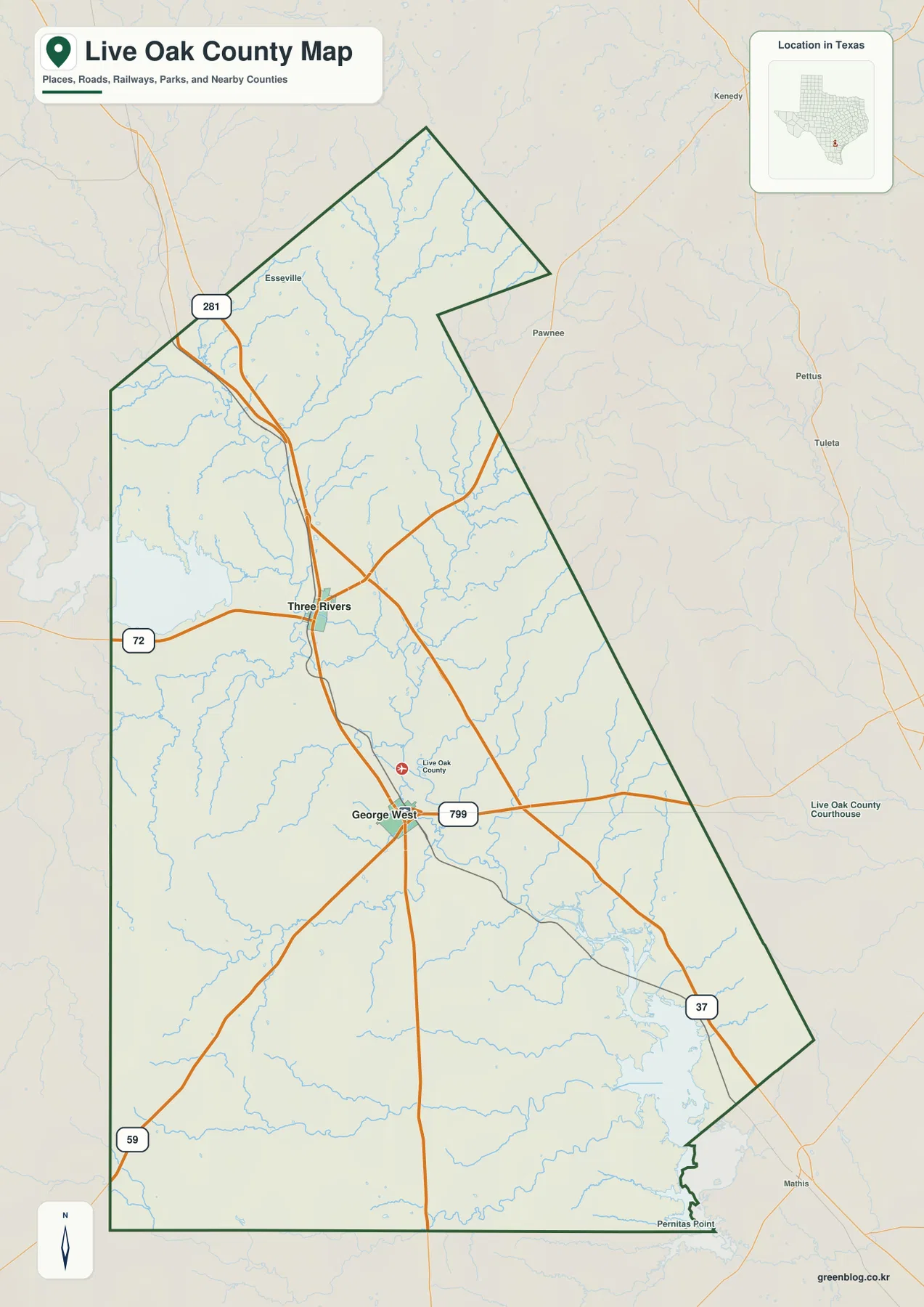
Three Rivers and George West are the best places to begin because they provide a simple north-south frame for the county. Route 281 passes through the Three Rivers area and continues toward George West. Route 72 extends west from Three Rivers, while Route 799 runs east from the George West area. Roads marked 59 and 37 leave the southern half in different directions. Once that road pattern is clear, the water and elevation maps explain why the broad spaces around the towns are crossed by so many stream valleys.
Table of Contents
Three Rivers and George West create a clear north-south reference
Three Rivers appears near the middle of the county but clearly north of George West. Route 281 runs through the town on a north-south line, and Route 72 approaches from the west. Esseville is labeled farther north, giving the upper part of the map another place reference before the county narrows toward its northern end.
George West lies farther south and is surrounded by a more obvious set of branching roads. Route 799 heads east, while the road marked 59 leaves toward the southwest. Route 37 runs toward the southeast. A county-related symbol near George West also helps identify the administrative-center area without requiring the reader to rely on the town label alone.
The long Route 281 connection between Three Rivers and George West is especially useful for orientation. It ties the two strongest settlement references together, while large areas east and west of the corridor contain fewer major town labels and many more thin water lines. The map therefore shows a county whose main towns are easy to locate but whose physical geography fills most of the space between them.
The city index reduces the county to two major settlement points
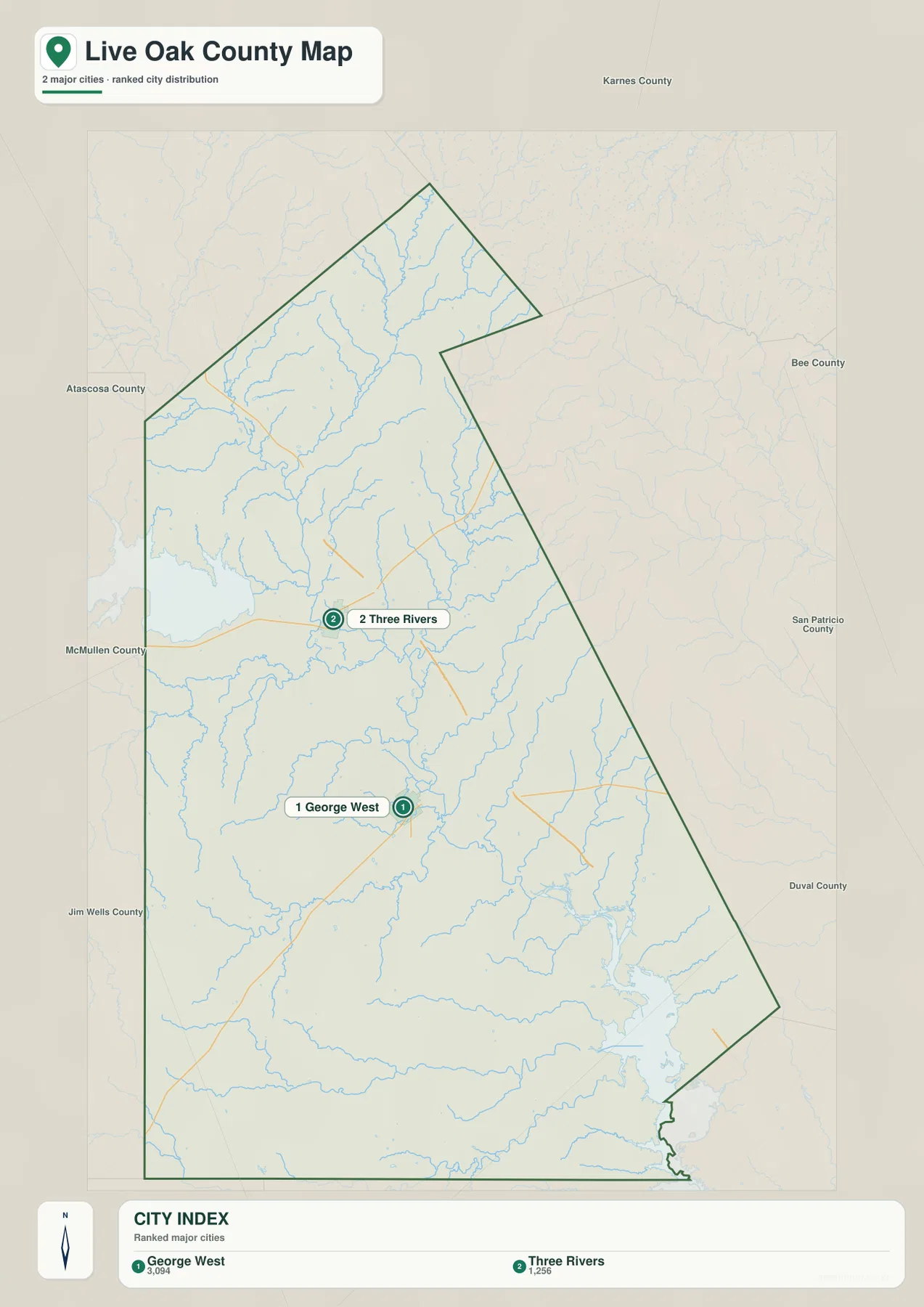
The ranked city map highlights only George West and Three Rivers. George West is number 1 and Three Rivers is number 2. The index also displays the values 3,094 and 1,256 beside the two names. Because the supplied map does not identify a year or statistical source for those numbers, this article treats them as part of the map’s city index rather than assigning them an unsupported date or interpretation.
Removing most of the road labels makes the distance between the two towns easier to see. George West occupies the south-central part of the county, and Three Rivers lies well to the north. The simplified background also shows how much of the county remains outside the immediate settlement areas, with streams and broad open terrain filling the eastern, western, and southern sections.
Karnes, Bee, San Patricio, Duval, Jim Wells, McMullen, and Atascosa counties are labeled around the outside for regional orientation. The city view is useful when the task is simply to show where the two main population centers lie. When a road number, smaller place, or direction of travel matters, the general county map provides the necessary detail.
Frio River and Nueces River organize the central drainage network
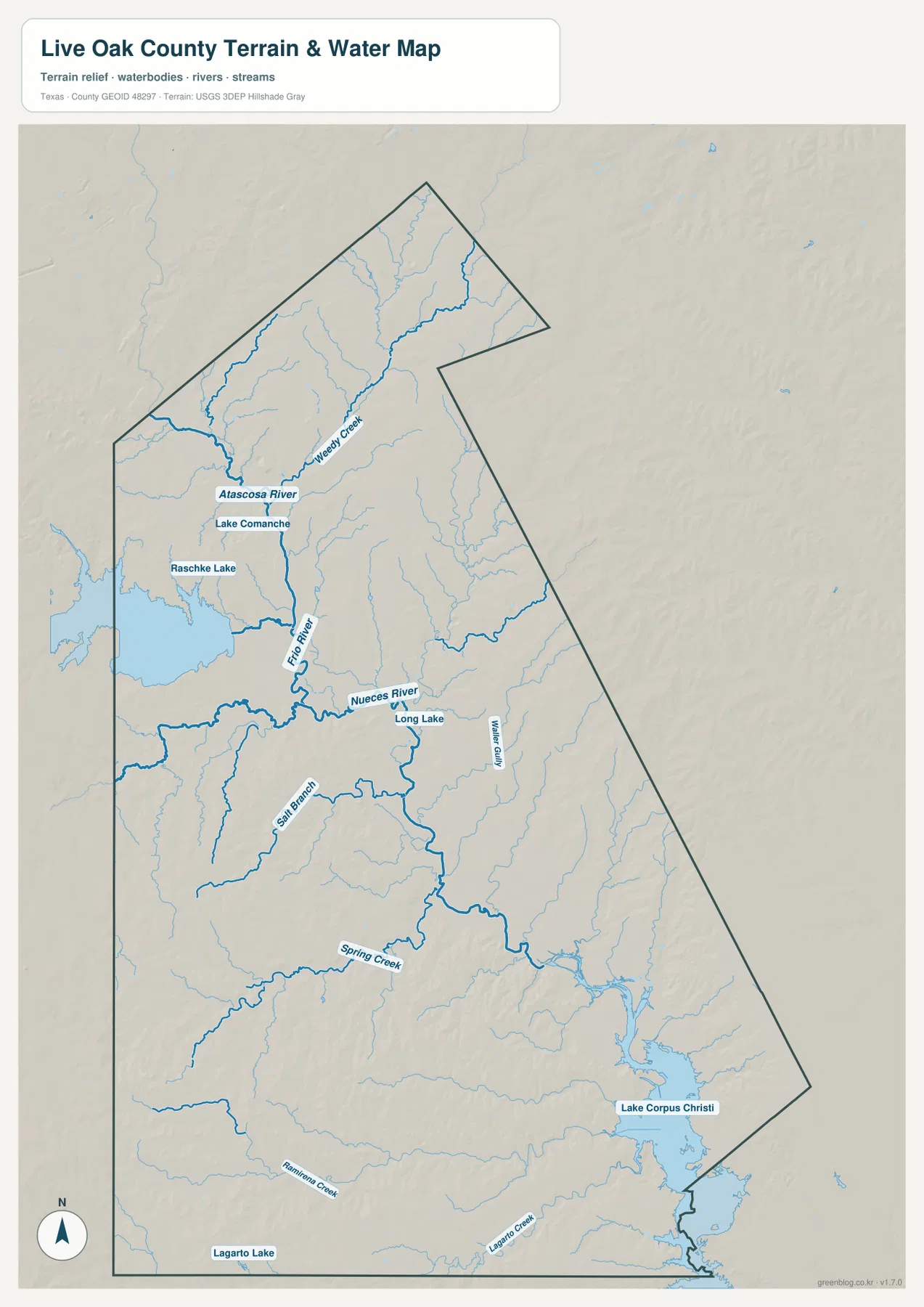
The terrain-and-water map changes the visual emphasis from roads to drainage. Frio River descends through the northwestern and central part of the county, while Nueces River becomes the major labeled channel farther south. Atascosa River is labeled in the northwestern interior near the upper Frio system. These larger rivers make it easier to understand where the many smaller tributaries are headed.
Weedy Creek is one of the clearest northern tributary labels. Lake Comanche and Raschke Lake appear farther west, while Long Lake is labeled close to the Nueces River in the central part of the map. Salt Branch enters the broader river network from the southwest. These features give the middle of the county a much more detailed water geography than can be seen on the road-focused general map.
South of the main river junctions, Spring Creek runs across the western interior, and Walker Gully is labeled farther east. Ramirena Creek and Lagarto Creek appear near the southern portion, with Lagarto Lake close to the southwestern edge. Lake Corpus Christi occupies a large area in the southeast and is the most prominent named water body near the bottom of the supplied map. This water layer is intended for geographic reference; it should not be used as a flood-hazard, legal-water-boundary, parcel, or navigation product.
Higher northern and southwestern ground surrounds a lower central river corridor
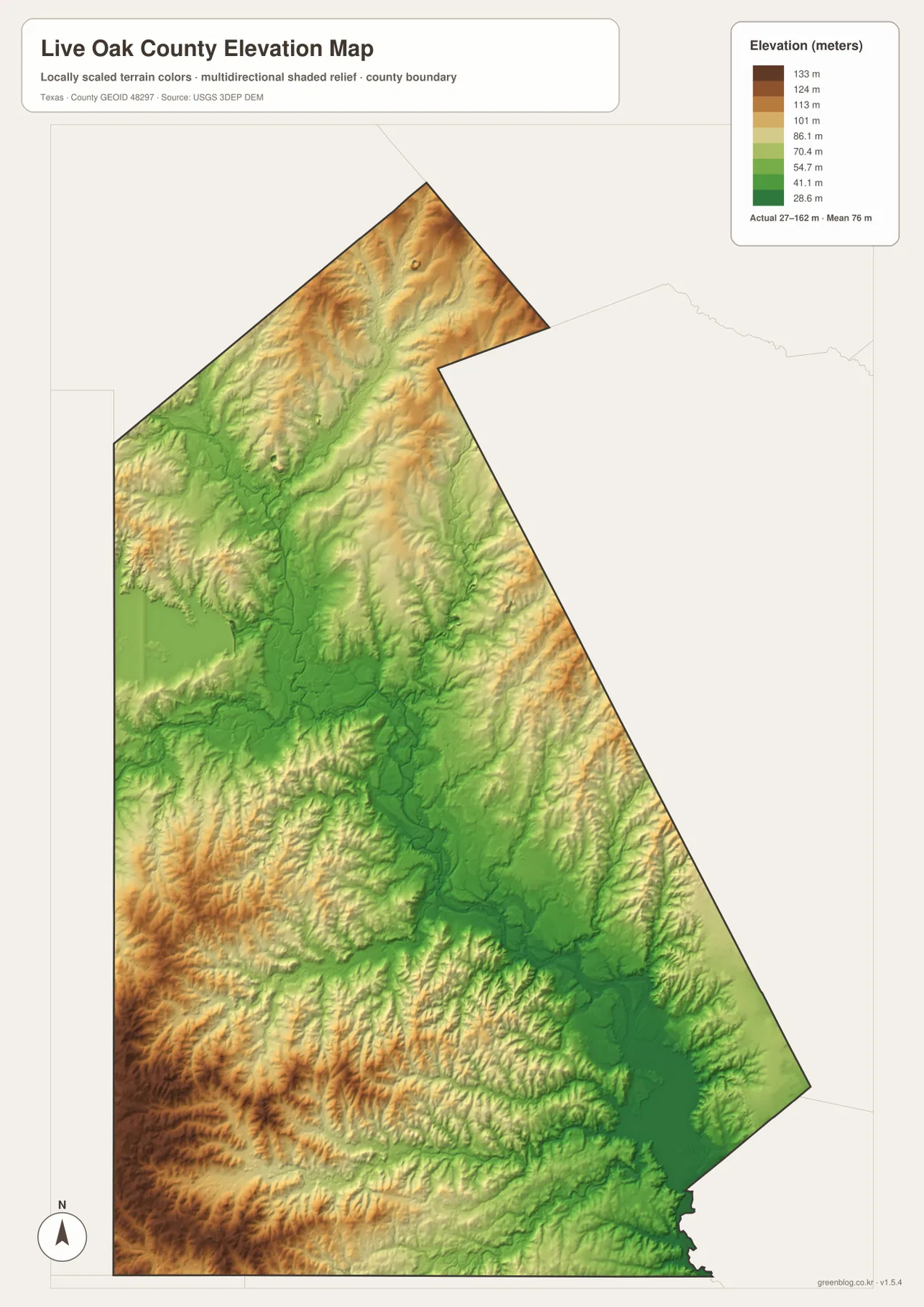
The elevation map reports an actual range of about 27 to 162 meters and a mean elevation of about 76 meters. The highest browns and tans occur across the north and in the southwestern part of the county. A long green corridor occupies the center, and lower colors become especially broad toward the southeast.
Comparing the elevation and water maps explains that central low area. The Frio and Nueces rivers follow lower terrain through the middle of the county, and narrow green branches extend outward where tributaries cut into the surrounding hills. The western and northern uplands are not completely flat; shaded relief shows repeated small ridges and stream valleys even inside the higher-colored areas.
The displayed difference between the minimum and maximum elevation is about 135 meters. That amount of relief is enough for the river corridors to stand out clearly even though Live Oak County is not a mountain county. The broad southeastern lowland also corresponds with the drainage toward Lake Corpus Christi. This image is best used for comparing relative elevation and terrain shape rather than as survey-grade or engineering-grade measurement.
Route 281 provides an easy way to compare settlements, rivers, and relief
Start on the general map at Three Rivers and follow Route 281 south toward George West. Switching to the water map in the same orientation brings the Frio and Nueces systems into view around that central corridor. The elevation map then shows a lower green band along much of the same area. This comparison makes it clear that the road corridor passes through a landscape shaped by river valleys rather than a featureless flat surface.
The southeastern side tells a second story. Route 37 leaves the George West area toward the southeast on the general map. In the water view, the same direction leads toward the lower Nueces drainage and Lake Corpus Christi. The elevation layer becomes greener in that part of the county, giving the three maps a consistent geographic relationship between road direction, water, and lower terrain.
The ranked city map is the quickest option when only George West and Three Rivers need to be located. The general map adds roads and smaller labels, the terrain-and-water map brings river and creek names forward, and the elevation map shows where the higher and lower ground lies. Small labels are often easier to inspect in the downloadable high-resolution JPG files than in the web previews.
Frequently Asked Questions
What is the easiest way to locate George West and Three Rivers?
Find Route 281 on the general map. Three Rivers is the northern city on that corridor, and George West is farther south. Route 72 extends west from Three Rivers, while Route 799 extends east from the George West area, giving each city a second directional reference.
Which water features stand out most clearly?
Frio River and Nueces River are the main central references. The map also labels Atascosa River, Weedy Creek, Long Lake, Salt Branch, Spring Creek, and Lake Corpus Christi, along with several smaller lakes and southern creeks.
What elevation range is shown for Live Oak County?
The supplied elevation map reports an actual range of about 27 to 162 meters and a mean of about 76 meters. Higher terrain is more common in the north and southwest, while the central Frio-Nueces corridor and the southeast are lower.
Sources and Reference Data
- U.S. Census Bureau TIGER/Line Shapefiles — official county-boundary and road geometry for geographic reference.
- USGS National Hydrography — official resources for rivers, creeks, lakes, and other water features.
- USGS 3D Elevation Program — official elevation resources used for terrain information.
- USGS The National Map Viewer — an official viewer for comparing multiple geographic layers.
Map File Information
Download four high-resolution A3 JPG maps of Live Oak County, Texas, in one ZIP file.
- Included Files: county map, ranked city map, terrain and water map, elevation map
- File Type: JPG
Related Maps
- Atascosa County Texas map
- San Patricio County Texas map
- Refugio County Texas map
- Webb County Texas map
- Wilson County Texas map
Green Map creates custom-edited map images using open geographic data sources such as geoBoundaries, Natural Earth, OpenStreetMap, and government open data.
These maps are edited visual materials, not raw data files, and are provided for education, documents, presentations, and graphic reference.