Beaufort County sits in eastern North Carolina where broad rivers, creeks, low Coastal Plain terrain, and long waterfronts shape the county as much as its roads do. Washington, the county seat, is the easiest place to begin because it sits near the transition from the Tar River to the broad Pamlico River system. Bath lies farther east along the same water-oriented corridor, Belhaven and Pantego occupy the northeastern part of the county, and Aurora stands apart in the southeast. The maps on this page show those relationships from three different angles, and the matching high-resolution JPG files are available together in a downloadable ZIP.
The county’s own community information notes that Beaufort County contains about 88,000 acres of water and includes seven municipalities: Aurora, Bath, Belhaven, Chocowinity, Pantego, Washington, and Washington Park. That large water component is visible immediately in the supplied maps. The Pamlico River stretches across the middle of the county, smaller creeks break up the surrounding land, and the eastern side opens toward Pamlico Sound. As a result, a place that appears close on a simple county outline may be separated from another community by a wide river or a network of creeks.
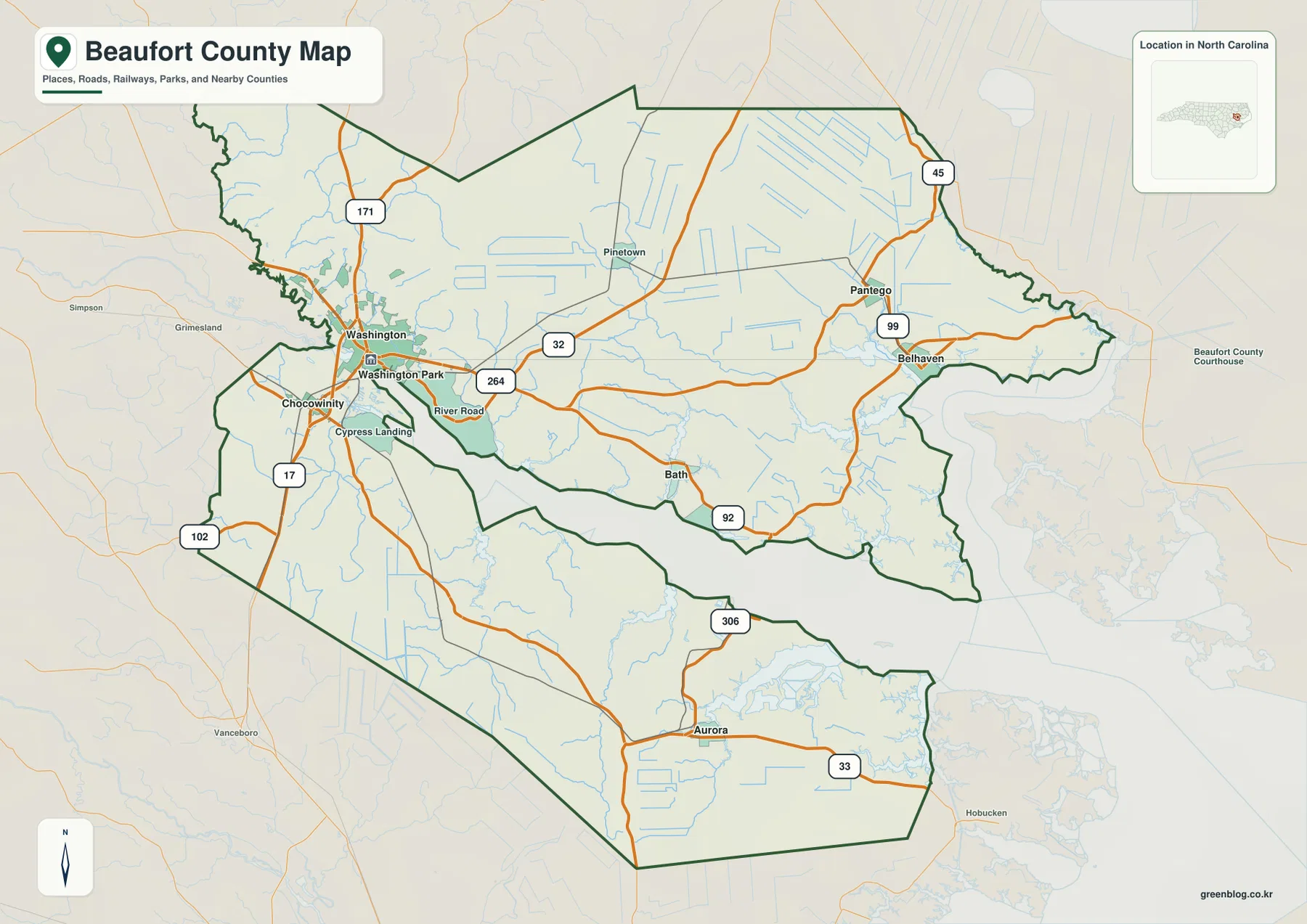
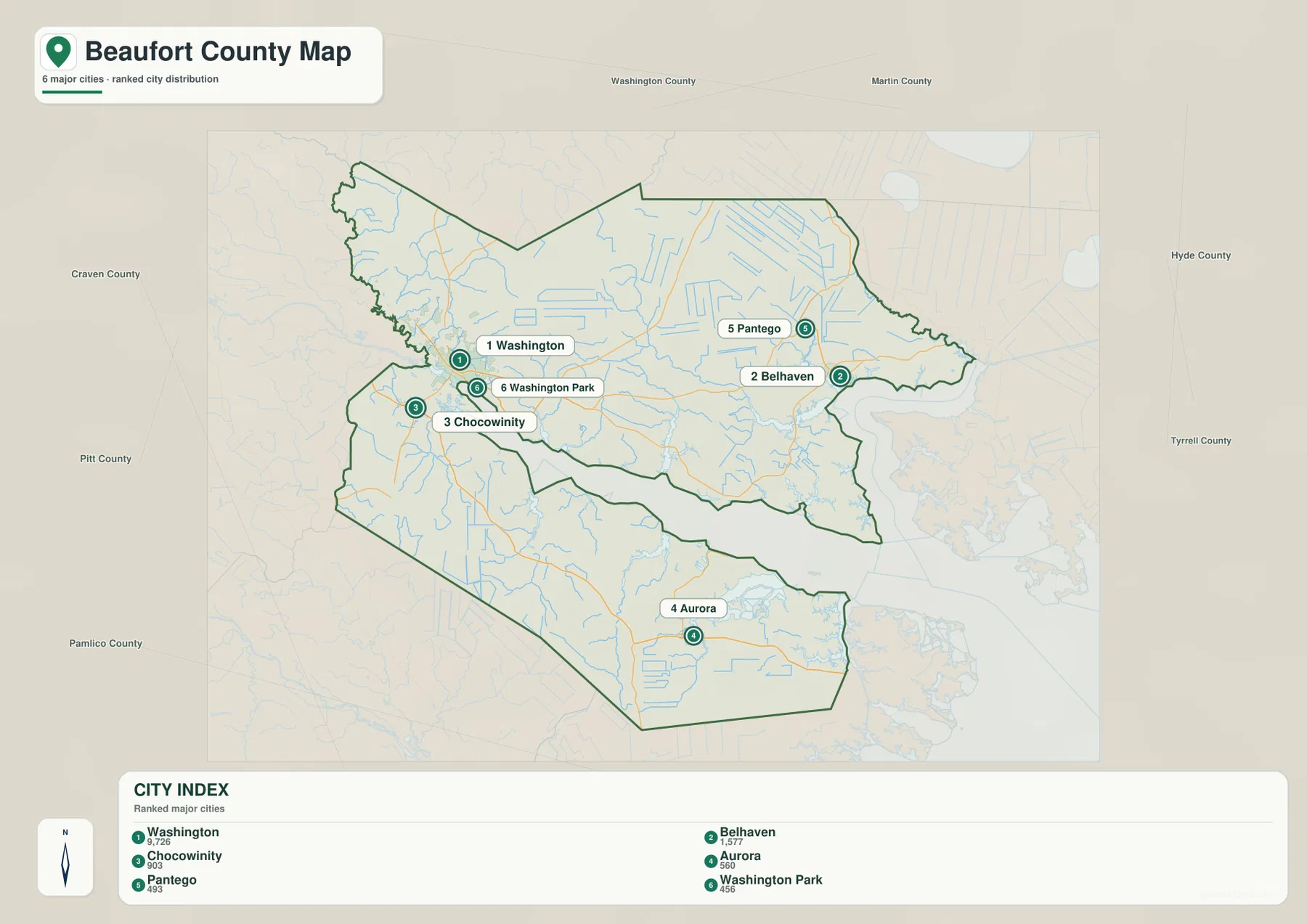
The first map is best for boundaries, roads, and place names. The second simplifies the settlement pattern by ranking six major places shown in the city index. The third removes much of the road emphasis and makes the water system easier to see. Used together, they provide a practical way to locate Washington, Bath, Belhaven, Aurora, and the smaller communities without turning the page into a technical GIS report.
Table of Contents
Washington anchors the road network on the western side
On the general county map, the strongest cluster of roads and place labels is around Washington, Chocowinity, and Washington Park. U.S. 17 passes through the western side near Chocowinity and Washington, while other numbered routes fan eastward and southward from that area. Route 32 crosses the central part of the county, 92 continues toward Bath and the river corridor, and 99 serves the Pantego-Belhaven side. Farther south, routes 306 and 33 help identify Aurora’s position. The map also shows 171 and 102 on the western side, making it possible to follow the county’s larger road pattern without needing street-level detail.
Washington is therefore a useful orientation point, but it should not be treated as if the entire county is concentrated there. Follow the roads east from Washington and the map opens into a much larger landscape. Bath sits near the north side of the Pamlico River, Pantego and Belhaven are farther northeast, and Aurora occupies a separate southeastern area. The irregular county outline follows a landscape cut by rivers, creeks, and low wetlands, so road connections matter more here than they would on a simple rectangular county map.
County names around the outside of the map also help with regional orientation. Pitt and Martin counties appear to the west and northwest, Washington County is shown to the north, Hyde County lies to the east, and Craven and Pamlico counties appear toward the southwest and south. These labels are useful for understanding where Beaufort County sits in eastern North Carolina. They are not a substitute for a legal boundary survey, but they make it much easier to place local roads and communities within the surrounding region.
The settlement pattern spreads far beyond Washington
The city distribution map strips away some of the general-map detail and emphasizes six places in its ranked index: Washington, Belhaven, Chocowinity, Aurora, Pantego, and Washington Park. Washington is clearly the largest and most prominent of the six. Chocowinity and Washington Park sit close to it on the western side, while Belhaven and Pantego form a smaller northeastern pair. Aurora is separated from the others in the southeastern part of the county. That arrangement is one of the most useful county-specific patterns on the page because it shows why Beaufort County cannot be understood as a single compact urban area.
Bath deserves separate attention because it is labeled on the general map even though it is not one of the six ranked locations in the supplied city index. The county government lists Bath as one of Beaufort County’s seven municipalities, and North Carolina Historic Sites identifies it as the state’s first town, founded in 1705. This difference between the two maps is useful rather than confusing: the city index is a simplified comparison of selected population centers, while the general map preserves a broader set of important place names.
The outer labels on the city map add another layer of context. Washington and Chocowinity are closer to the Pitt and Craven county side of Beaufort County, while Belhaven and Pantego sit much nearer the Hyde County direction. Aurora is farther south and east, closer to the lower Pamlico River and coastal-water landscape. Those positions explain why a drive between communities may feel longer than the straight-line separation on a small map suggests. The city map is intended for relative location and distribution, not turn-by-turn navigation or travel-time estimates.
Pamlico River, creeks, and sound-side water define the county
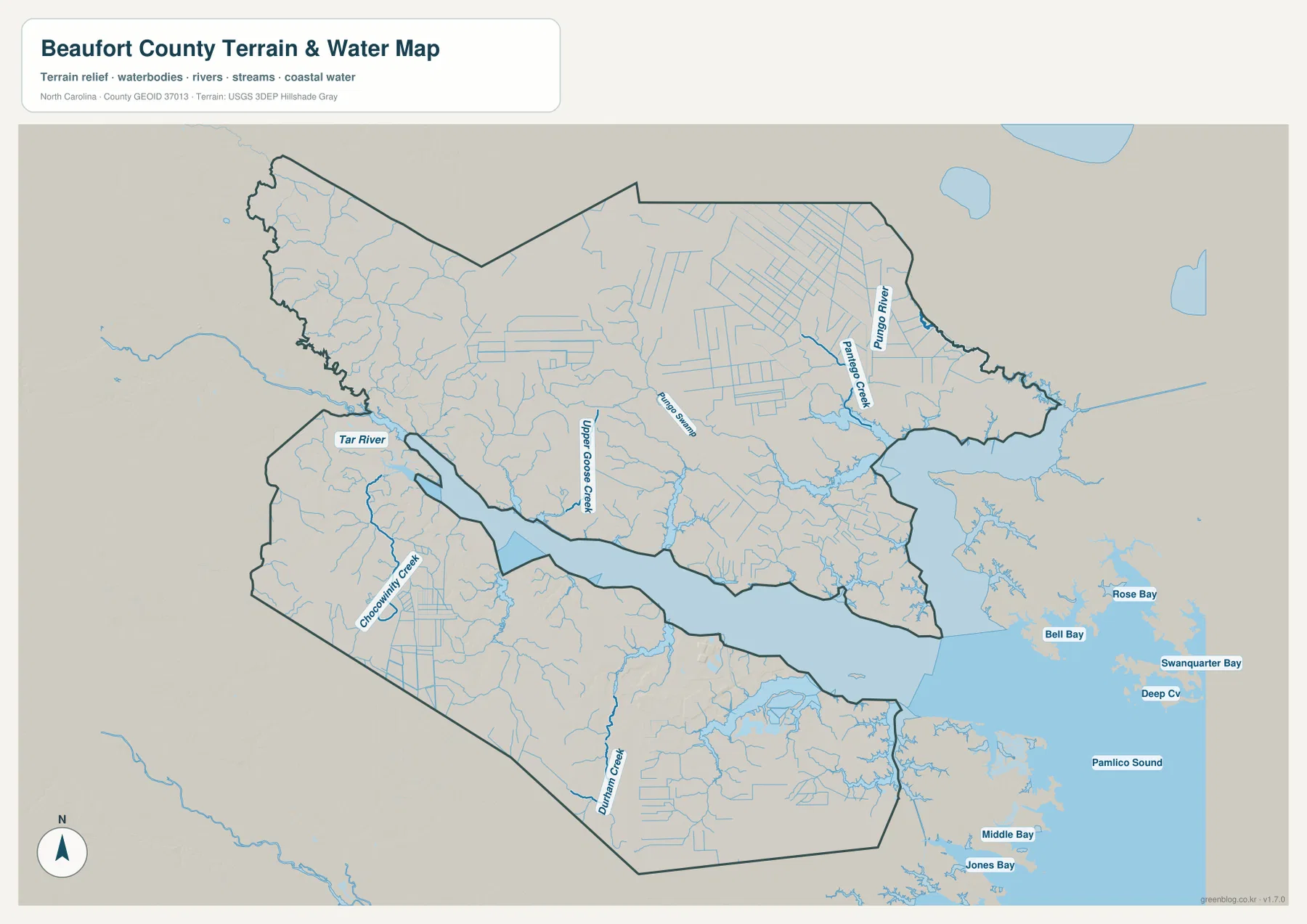
The terrain and water map makes Beaufort County’s most distinctive physical feature much clearer. The Tar River enters from the west near Washington, and the broad Pamlico River system extends eastward through the center of the county. Instead of a narrow blue line, much of this corridor is a wide body of water that separates large parts of the northern and southern land areas. That is why the river is a better orientation reference than a simple compass direction when comparing Bath with Aurora or the northeastern communities with the lower part of the county.
Several smaller waterways are labeled as well. Pungo River and Pantego Creek appear in the northeast, Upper Goose Creek lies in the central-northern river area, Chocowinity Creek is shown toward the west and southwest, and Durham Creek runs through the southern part of the county. Farther east, the map opens toward Pamlico Sound and shows a complicated shoreline with bays and narrow water connections. These features help explain the irregular land shapes that are less obvious on a road-focused map.
The shaded terrain is intentionally subtle because Beaufort County belongs to North Carolina’s low Coastal Plain rather than a mountain or piedmont setting. The county’s official history describes flat land and large bodies of water as characteristic features, while Goose Creek State Park provides a concrete example of the local environment. The park, located in Beaufort County along the Pamlico River, protects wetlands and a cypress swamp and provides access to estuarine habitats. Seeing Upper Goose Creek and the Pamlico River on the supplied water map gives that park setting a useful geographic frame.
This map should be used as a water-and-terrain reference, not as a flood-risk, parcel, depth, boating, or engineering map. It does not show regulatory flood zones or navigation hazards. Its value is in showing where the major rivers and creeks sit in relation to the county boundary and communities. For flood insurance, construction, boating, or other safety decisions, the appropriate current agency data should be checked separately.
Bath and Washington make more sense when the river stays in view
Bath is small on a modern county map, but its location tells an important part of Beaufort County’s story. North Carolina Historic Sites reports that European settlement near the Pamlico River began in the 1690s and that Bath was founded in 1705 as North Carolina’s first town. Its early development depended on river access, and it became the colony’s first port of entry. On the map, Bath’s position along the Pamlico River makes that history easier to understand: it was not an inland crossroads that happened to become old, but a waterfront settlement tied directly to navigable water.
Washington came later and lies farther upriver. The Historic Bath history notes that Washington was established in 1776 and that Beaufort County government moved there in 1785. The county’s own history page describes Washington as the cultural and economic center of the county today. When Washington and Bath are viewed together, the map shows a shift in local importance along the same river-oriented landscape rather than two unrelated town names.
Belhaven adds another waterfront center in the northeast, while Aurora gives the southern part of the county a distinct reference point. The county government notes that many Beaufort County municipalities have waterfronts and that those waterfronts historically supported trade in naval stores, lumber, farm products, and commercial fishing. Modern uses have changed, but the geographic reason for the waterfront pattern remains easy to see. Rivers and sounds are not peripheral features here; they are part of the county’s settlement history and still help explain why its towns are spaced the way they are.
Choosing the best view for Washington, Bath, Belhaven, or Aurora
Use the general county map when the question starts with a road, boundary, or named place. It is the best view for following U.S. 17 near Washington and Chocowinity, then tracing the numbered routes toward Bath, Pantego, Belhaven, and Aurora. It also keeps neighboring-county context visible. If the question is instead about how the main communities are distributed, the city map is faster because it reduces the visual clutter and makes the Washington cluster and the more distant northeastern and southeastern places immediately apparent.
Choose the water and terrain map when the Pamlico River or smaller creeks are central to what you are trying to understand. The wide river corridor explains why the county feels divided into several land areas, while Pungo River, Pantego Creek, Goose Creek, Chocowinity Creek, and Durham Creek show how thoroughly water reaches into the county. This view is especially helpful before looking at a park, historic waterfront, or community near the sound because it provides a physical setting that a city-only map cannot show.
The WebP maps embedded in the article are sized for convenient browser viewing. If you need larger files for printing, classroom material, reference work, or close inspection of labels, the ZIP below contains the matching A3 high-resolution JPG versions. There are three JPG files in the archive, corresponding to the general county map, the city distribution map, and the terrain-and-water map described above.
Frequently Asked Questions
Why does the Pamlico River make the northern and southern parts of Beaufort County feel farther apart?
The Pamlico River is a broad water body through the middle of the county, not just a narrow stream that roads can cross anywhere. Travel between areas depends on the available road and bridge network, so straight-line separation can be misleading. Comparing the general road map with the water map makes this especially clear for places north of the river and Aurora in the southeast.
Why is Bath important even though it is not one of the six places in the city index?
The supplied city map uses a six-place ranked index: Washington, Belhaven, Chocowinity, Aurora, Pantego, and Washington Park. Bath remains clearly labeled on the general county map and is one of the county’s seven municipalities. It is also historically significant as North Carolina’s first town, so the general map is the better view when Bath itself is the main point of interest.
What is included in the Beaufort County map download?
The download ZIP includes three A3 high-resolution JPG files: the general county map, the city distribution map, and the terrain-and-water map. The WebP images in the article are browser previews, while the JPG files are intended for situations where a larger image is more useful.
Map File Information
The ZIP contains A3 high-resolution JPG versions of the Beaufort County boundary-and-road map, city distribution map, and terrain-and-water map shown on this page.
- File Type: ZIP archive
Related Maps
Sources and References
- Beaufort County official profile – waterways and municipalities
- Beaufort County official history – Washington, Bath, and Coastal Plain geography
- North Carolina Historic Sites – Historic Bath
- North Carolina State Parks – Goose Creek State Park
- USGS National Hydrography
Green Map creates custom-edited map images using open geographic data sources such as geoBoundaries, Natural Earth, OpenStreetMap, and government open data.
These maps are edited visual materials, not raw data files, and are provided for education, documents, presentations, and graphic reference.