Monroe County is centered on Bloomington, with Ellettsville and Stinesville to the northwest and a broad lake-and-hill landscape extending south and east. You can download the high-resolution JPG ZIP directly from this page when you need larger road labels, creek names, lake features, or elevation shading. This Monroe County Indiana Map page combines the Bloomington road network with a three-place city-connections view, Monroe Lake and Lake Lemon, and a 150–303 meter relief surface shaped by deep creek valleys and high ridges.
Bloomington is the easiest place to use for orientation because it has the largest developed footprint and sits near several state routes. Ellettsville lies to the northwest and Stinesville farther in the same general direction, while Smithville-Sanders and Harrodsburg provide southern references. Indiana’s official county information identifies Bloomington as the Monroe County seat and lists Bloomington, Ellettsville, and Stinesville among the county’s cities and towns.
The water and relief maps quickly shift attention away from the urban center. Monroe Lake dominates the southeast, Lake Lemon anchors the northeast, and Griffy Reservoir and University Lake sit closer to Bloomington. The elevation legend gives an actual range of about 150 to 303 meters and a mean of 222 meters. Lake basins and creek valleys stay low and green, while strong ridge country spreads across the west and northeast.
Table of Contents
Bloomington anchors the road network while smaller places spread toward the county edges
Bloomington has by far the largest developed area on the general map. State Road 37 runs along the western side of the city, Route 46 crosses the Bloomington area, and Routes 45, 48, and 446 provide strong directional references. IU Health Bloomington and the Indiana State Police Department are also labeled, giving the urban core several easy visual anchors.
Ellettsville lies northwest of Bloomington and has a long developed footprint along the road network. Stinesville is much smaller and farther north near the county’s irregular northwestern boundary. Between and east of those communities, roads share the landscape with numerous creek lines, so the general map becomes less urban and more topographic as it approaches the northern edge.
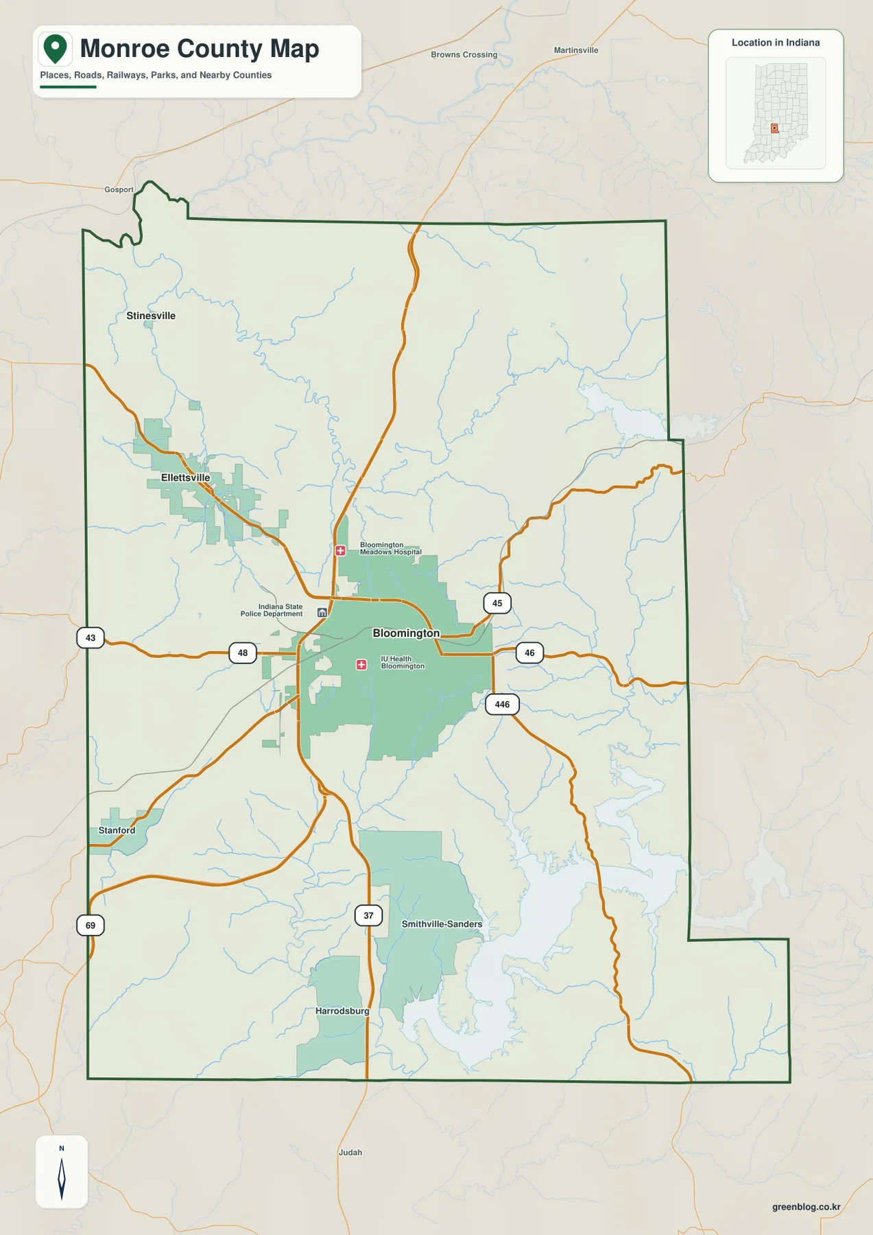
South of Bloomington, settlement labels become more widely spaced. Smithville-Sanders occupies the south-central area, Harrodsburg lies farther south near Route 37, and Stanford provides a western reference near Route 69. As the map approaches the Monroe Lake side, road labels become less dominant and the creek-and-reservoir landscape becomes more important.
The eastern side is organized by Routes 45, 46, and 446, which connect Bloomington with the hill-and-lake country. The county boundary also makes several sharp steps and turns in the east. Those boundary shapes are helpful when switching to the water and elevation views, where most settlement labels disappear but the lake basins and drainage corridors remain easy to identify.
The connector map places Ellettsville and Stinesville northwest of Bloomington
The supplied city-connections graphic uses Bloomington as the hub and highlights Ellettsville and Stinesville. The printed index values are 80,409 for Bloomington, 6,698 for Ellettsville, and 297 for Stinesville. These figures belong to the supplied map edition rather than a live demographic feed. The strongest geographic message is that Ellettsville lies about 8 miles from Bloomington and Stinesville about 11 miles away on a more northwesterly line.
| Map rank | Place | Value printed on map | Straight-line distance from Bloomington | Direction |
|---|---|---|---|---|
| 1 | Bloomington | 80,409 | Hub | Central |
| 2 | Ellettsville | 6,698 | 8 mi | Northwest |
| 3 | Stinesville | 297 | 11 mi | Northwest |
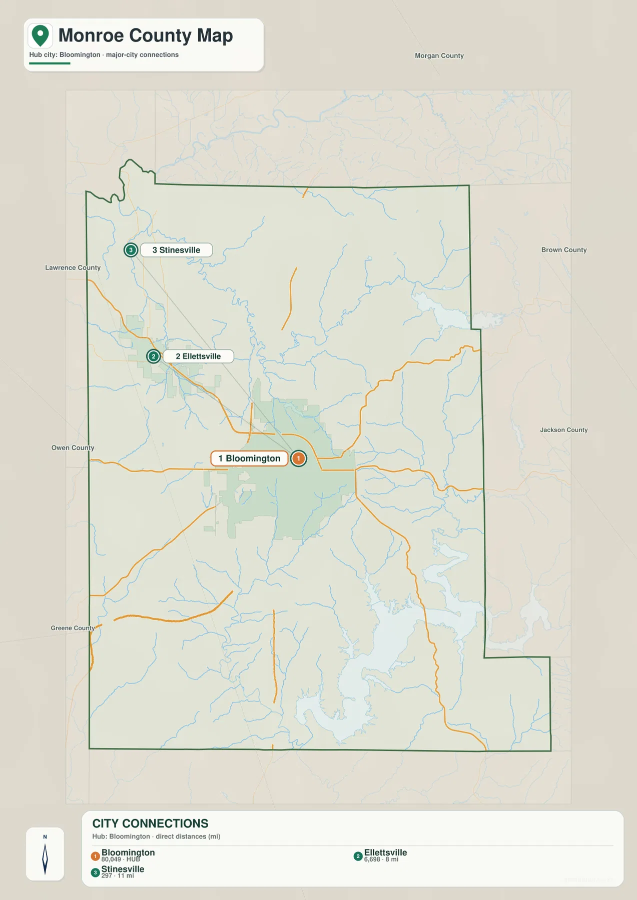
The 8- and 11-mile labels are direct point-to-point distances, not driving mileage. Actual road travel depends on the route and the exact starting and ending locations. The general map is therefore the better companion when the goal is to see how roads actually link Bloomington with Ellettsville and the smaller northwestern communities.
This connector map is deliberately limited to three highlighted places. It does not define municipal boundaries, commuting areas, or the location of every settlement in Monroe County. Stanford, Smithville-Sanders, Harrodsburg, and other labels remain available on the general map, while current population analysis should use an up-to-date official statistical source.
Monroe Lake dominates the southeast while Lake Lemon and smaller reservoirs organize the north
Monroe Lake is the most prominent water feature on the terrain-and-water map. Its branching shoreline covers a large part of the southeastern county and provides an unmistakable reference for the lower-right section of the map. Indiana DNR identifies Monroe Lake as a 10,750-acre lake, which helps explain why it visually overwhelms the county’s smaller reservoirs and lakes.
Lake Lemon sits near the northeastern boundary, while Beanblossom Lake and Lazy Lake lie farther northwest. Bryant Creek Lake provides another northern landmark. Closer to Bloomington, Griffy Reservoir and University Lake form a small pair of water references. These smaller waters are useful when moving between the city map and the physical-geography views.
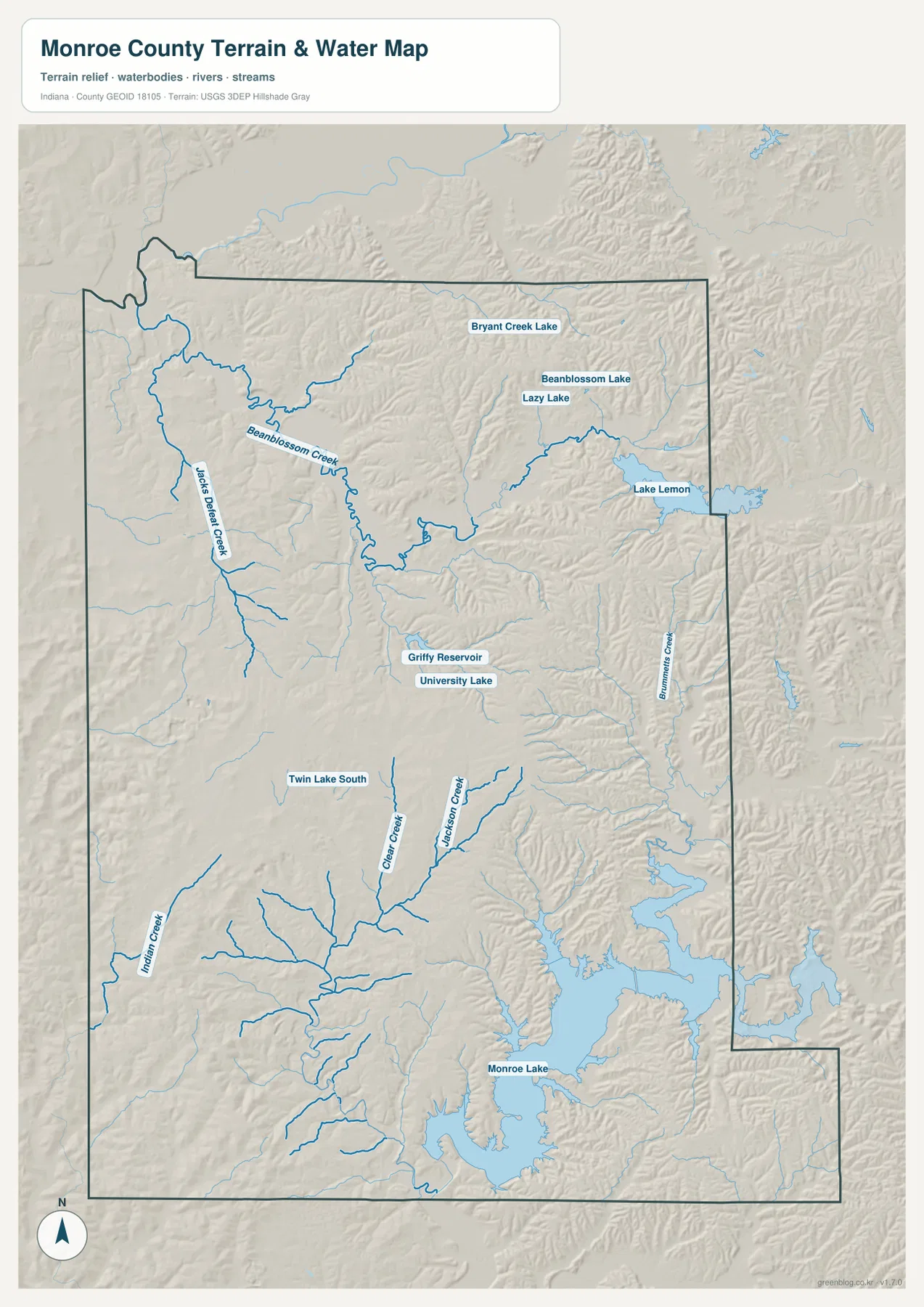
Beanblossom Creek and Jacks Defeat Creek create long low corridors in the north. Brummets Creek cuts a separate eastern valley, while Clear Creek and Jackson Creek provide strong references south of Bloomington. Indian Creek appears farther southwest. The county is therefore organized less by one dominant river than by a network of creeks threading between lakes and ridges.
Twin Lake South provides a small southwestern water reference, and numerous tributaries feed the Monroe Lake basin from the west and north. This terrain-and-water view is meant for geographic orientation. Flood exposure, current lake levels, water quality, navigation rights, and legal water boundaries require the current agency source designed for those decisions.
The 150–303 m surface contrasts lake basins and creek valleys with strong western and northeastern ridges
The elevation legend gives an actual Monroe County range of about 150 to 303 meters and a mean of 222 meters. Greens represent lower ground, while yellow, tan, and brown mark progressively higher terrain. Monroe Lake and Lake Lemon occupy low basins, and the strongest ridge relief appears across the western and northeastern portions of the county.
The Bloomington area sits within a mix of creek lowlands and moderate hills rather than one flat urban surface. Griffy Reservoir and University Lake occupy lower terrain north of the city, while surrounding ridges rise quickly outside those basins. The contrast becomes more obvious when the road map and elevation view are compared at the same locations.
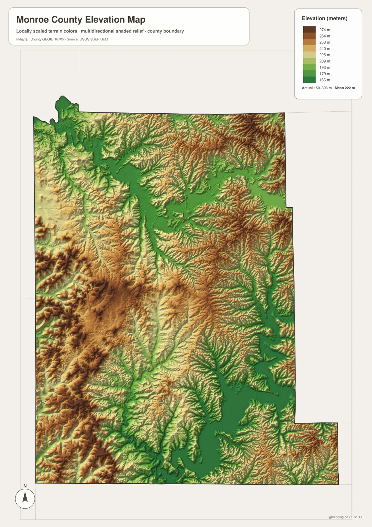
The west and southwest contain especially strong ridges. Near the Stanford side and along the western boundary, brown uplands repeat in long bands with narrow creek valleys between them. The northeast shows a similar ridge-and-valley pattern, although Lake Lemon and its connected low ground interrupt the higher surface.
Monroe Lake creates the largest low basin in the southeast, with long arms extending into creek-cut valleys. Higher ridges remain on the east and south sides of the reservoir, so the lake is surrounded by varied terrain rather than a broad flat plain. A useful county-scale reading is a central urban-and-creek lowland, strong western and northeastern ridge belts, and the large Monroe Lake basin in the southeast.
The 150–303 meter range is intended for county-scale comparison, not survey-grade measurements. A parcel, building site, road grade, or drainage design requires source elevation data such as the USGS 3D Elevation Program or measurements from a qualified survey.
Keep Bloomington fixed while matching the city distances to lake basins and ridge country
For settlements and roads, begin with Bloomington near Routes 37 and 46. Move northwest to Ellettsville and Stinesville, then use Smithville-Sanders and Harrodsburg for the south and Stanford for the west. Routes 45 and 446 help connect the central city with the lake-and-hill landscape on the eastern side.
The connector map is useful when the goal is to compare Bloomington directly with Ellettsville and Stinesville. It shows approximately 8 and 11 miles of straight-line separation, respectively. Those measurements are geometric rather than driving distances, so actual travel should be planned with a current road map or navigation source.
For physical geography, find Monroe Lake and Lake Lemon first, then add Griffy Reservoir, University Lake, Beanblossom Creek, and Clear Creek. Switching to the elevation view at those same positions shows the waters in low green basins and the western and northeastern ridges in higher tan and brown terrain. This side-by-side comparison makes Monroe County’s strongly dissected hill-and-valley landscape much easier to understand.
The WebP images on this page are reduced previews. The Monroe County archive contains four original 2572×3638-pixel JPG files covering the general county map, city-connections map, terrain-and-water map, and elevation map. The larger originals are better for printing or reading small road, creek, lake, and place labels.
A useful comparison is to keep Bloomington fixed as the central reference. Find Ellettsville and Stinesville on the general map, compare their direct spacing on the connector view, move to the water map to locate Monroe Lake and Lake Lemon, and finish with the relief map by comparing those basins with the western and northeastern ridges. The sequence links settlement, water, and terrain without requiring every road or creek name to be memorized.
Frequently Asked Questions
How far are Ellettsville and Stinesville from Bloomington on the connector map?
The supplied graphic places Ellettsville about 8 miles from Bloomington and Stinesville about 11 miles away. Both are straight-line distances between mapped place points, not road-driving mileage, so actual travel distances will vary.
Which water features are easiest to recognize?
Monroe Lake is the dominant southeastern water body, while Lake Lemon anchors the northeast. Griffy Reservoir and University Lake are useful near Bloomington, and Beanblossom Creek, Jacks Defeat Creek, Clear Creek, and Jackson Creek define major low corridors. The water map is for geographic orientation rather than flood or legal-boundary decisions.
Can the 150–303 m elevation range be used for exact site measurements?
No. The elevation image gives a county-wide range with a mean of 222 meters and is intended for comparing lake and creek lowlands with the surrounding ridges. For a Monroe County parcel, building site, road grade, or drainage project, use original elevation data or a qualified survey instead of this county-scale relief image.
Map File Information
The Monroe County ZIP combines the general road-and-place map, Bloomington city-connections map, terrain-and-water map, and elevation map as full-resolution JPG originals.
- File Type: ZIP containing four 2572×3638px JPG files
Related Maps
Sources and References
The article is based primarily on the supplied Monroe County map set and asset manifest. The following official sources provide county, Bloomington, Monroe Lake, boundary, hydrography, and elevation context.
- Monroe County, Indiana – official county information including Bloomington as county seat and the county’s cities and towns
- Indiana DNR – Monroe Lake – official information on Monroe Lake and its recreation property
- U.S. Census Bureau TIGER/Line Shapefiles – boundary reference for Monroe County and its incorporated-place framework
- USGS National Hydrography – hydrography reference for Monroe Lake, Lake Lemon, reservoirs, and named creeks
- USGS 3D Elevation Program – source terrain data for checking precise elevations beyond the county-scale relief image
Green Map creates custom-edited map images using open geographic data sources such as geoBoundaries, Natural Earth, OpenStreetMap, and government open data.
These maps are edited visual materials, not raw data files, and are provided for education, documents, presentations, and graphic reference.