Pierce County in southeastern Georgia is easier to understand when the county outline, town locations, waterways, and low-relief terrain are viewed together rather than as separate facts. Blackshear is the county seat and the main hub on these maps; Patterson and Offerman sit to the northeast, while the county map also labels Mershon and Bristol farther north. The downloadable set on this page includes four high-resolution A3 JPG maps in one ZIP, so readers can use the larger files for printing or close inspection after reviewing the WEBP previews.
The supplied maps emphasize a practical geography of Pierce County. Routes labeled 84, 203, 15, 121, 32, and 38 connect the principal places shown, while the water map adds the Alabaha River, Satilla River, Little Satilla River, and a network of creeks and branches. The elevation surface ranges from roughly 13 to 55 meters, with a mean of about 34 meters, revealing subtle but meaningful differences between the higher western side and lower eastern and southern areas. The maps are reference products, not parcel, flood-hazard, navigation, or engineering-survey maps.
Table of Contents
Blackshear, Major Roads, and the Shape of Pierce County
Blackshear appears near the southwestern half of the county and acts as the clearest orientation point on the county map. Route 84 runs through Blackshear toward Patterson, while Route 203 approaches from the northwest. Routes 15 and 121 continue southward from the Blackshear area, and the Patterson area is crossed by routes labeled 32 and 38. This road pattern makes the county seat a useful starting point for reading the rest of the map, even though the graphic does not attempt to show every local road.
Moving northeast from Blackshear, Patterson is the next prominent incorporated place and Offerman lies a little farther northeast. Mershon and Bristol are labeled in the northern part of the county, giving the map more context than a simple three-city diagram. Waycross is shown just beyond the southwestern boundary, which helps place Pierce County relative to a larger nearby community without suggesting that Waycross is inside the county. The outline itself is irregular, with step-like turns on the west and northwest and a more winding eastern and southern edge.
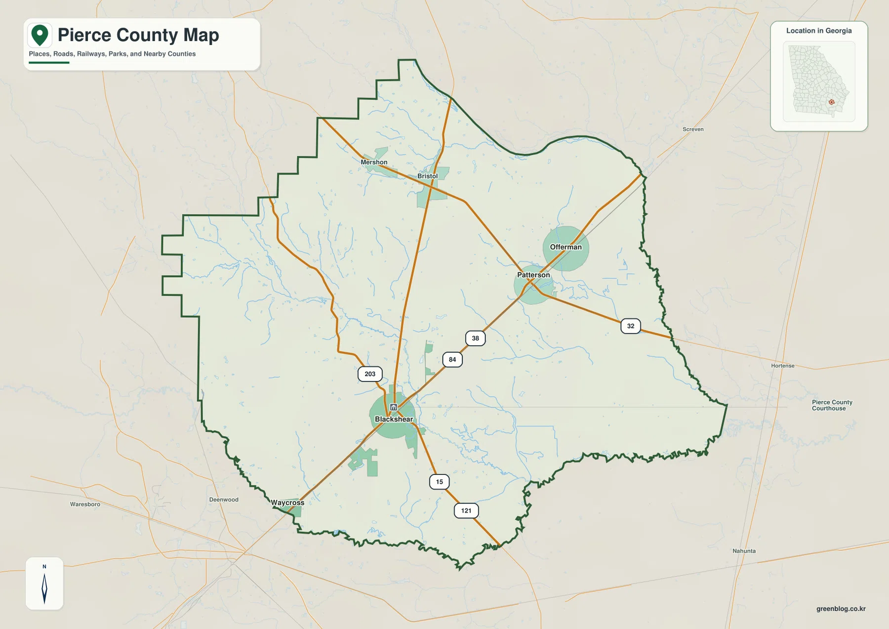
The road map is most useful when the viewer wants a quick answer to “where is this place within the county?” rather than turn-by-turn navigation. For example, it makes the northeast relationship between Blackshear, Patterson, and Offerman immediately visible, and it shows that the northern Mershon–Bristol area is separated from the county-seat corridor. The water lines in the background also hint that roads and settlements occupy a landscape crossed by many small drainage channels, a pattern that becomes much clearer on the dedicated water map.
Patterson and Offerman as Straight-Line Connections from Blackshear
The city-connections map simplifies the county by treating Blackshear as the hub and drawing direct connectors to Patterson and Offerman. Patterson is labeled about 9 miles from Blackshear and Offerman about 11 miles away. Those figures are straight-line distances between mapped points, not driving mileage along Route 84 or any other road. A traveler should therefore use a routing service for actual road distance, while this map is better suited to comparing direction and spacing.
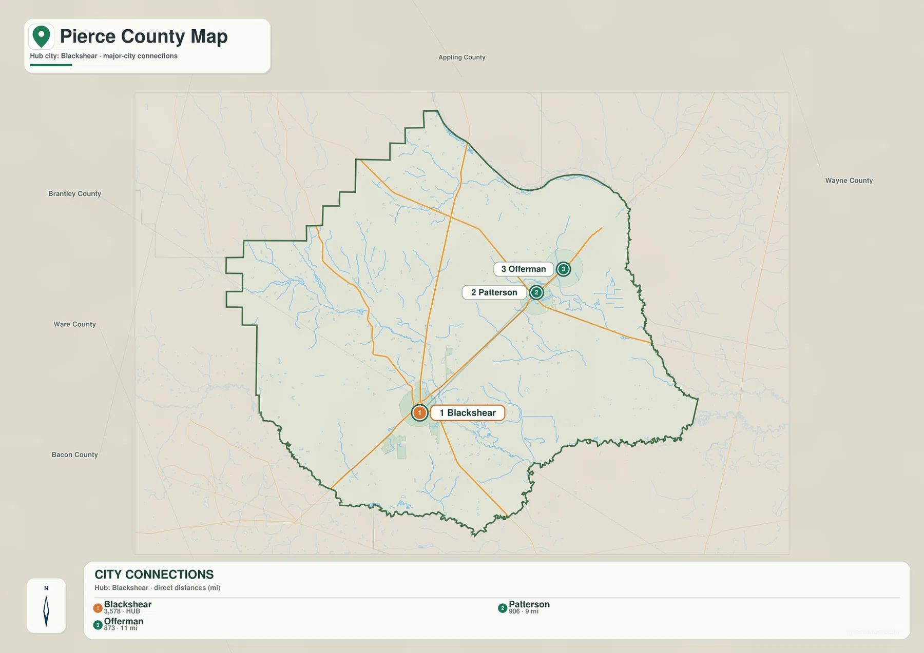
Reading this diagram beside the county map adds useful context. Patterson lies along the same general northeast corridor visible on the road map, while Offerman is displaced farther to the northeast. The connector lines deliberately ignore road curves, intersections, and local access. They also leave out smaller communities such as Mershon and Bristol because the graphic is designed around the leading city connections rather than a complete settlement inventory. That distinction prevents the simplified city map from being mistaken for a comprehensive place map.
The hub layout is also a quick way to judge scale inside the county. Patterson and Offerman are not on opposite ends of Pierce County; they are relatively close to each other in the northeastern sector when compared with the full county outline. Blackshear sits farther southwest, so the three labeled city points form a diagonal pattern rather than a north–south or east–west line. That simple geometry is easier to recognize on the connections map than on the denser county reference map.
The Alabaha, Satilla, and a Dense Network of Smaller Waterways
Water is the most intricate feature in the four-map set. The Satilla River follows the southern side of Pierce County, while the Alabaha River crosses from the west toward the south-central area. In the east, the Little Satilla River occupies a separate corridor. Between those larger rivers, the map labels Fishing Creek, Crooked Creek, Tenmile Creek, Hurricane Creek, Otter Creek, and several smaller branches, showing that the county is drained by many connected channels rather than by one dominant stream alone.
The western side includes Mill Branch and Hurricane Creek, and the north-central area shows Fishing Creek and Crooked Creek. Farther east, Long Branch and Griffin Branch appear above Otter Creek, while Zero Bay and Silver Rice Branch are labeled near the eastern side. A “Lake View” label appears near the lower central portion of the map. These names help local readers match the broader river system to smaller features that may disappear on a general road map.
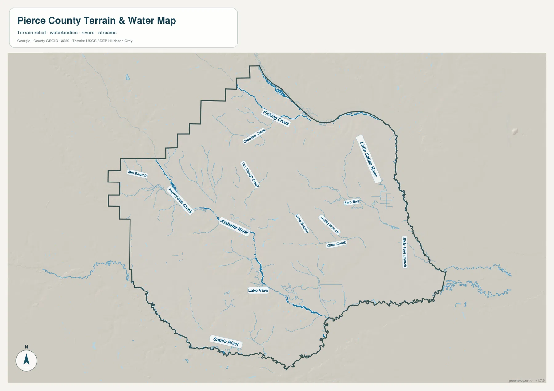
The water map should be read as a location reference, not as a flood or navigation chart. It does not report flood frequency, water depth, current, channel condition, or legal access. Its value is in showing where the named channels sit inside the county and how the smaller creeks feed toward larger river corridors. When the same waterways are compared with the elevation map, several of the lower green bands line up with the general direction of river and creek valleys.
This relationship is particularly visible around the Alabaha corridor. A low band cuts through the western and central part of the elevation surface and continues toward the south, echoing the direction shown on the water map. The eastern side is broadly lower as well, matching the concentration of the Little Satilla River and smaller eastern drainage features. The maps do not prove a hydrologic model, but they do let a general reader see the basic connection between lower ground and mapped waterways.
Elevation Falls from the Western Interior toward Eastern and Southern Lowlands
The elevation legend gives an actual range of approximately 13 to 55 meters and a mean near 34 meters. That is a relatively small vertical range, yet the shaded surface still reveals clear local relief. Brown and tan colors dominate much of the west and northwest, while greens expand across the eastern side and along the southern edge. The county therefore does not read as perfectly flat even though it lacks the large elevation changes associated with mountain counties.
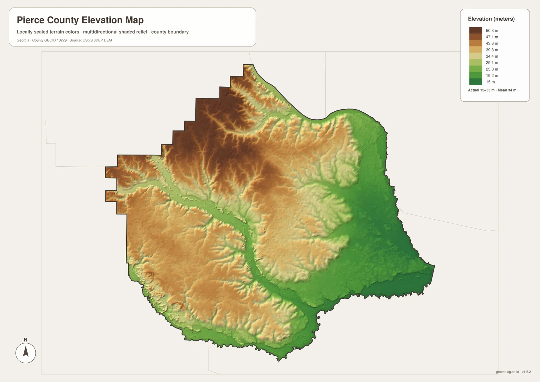
Small valleys cut into the higher western surface like branching fingers, and a broader low corridor runs from the west-central area toward the south. In the east, the terrain becomes more consistently green, suggesting a wider lowland rather than isolated narrow valleys. The south-central and southeastern margins are also low relative to the interior. These differences are easiest to see in the color transitions, while the hillshade adds texture that makes subtle ridges and depressions visible.
The elevation map is generalized for regional comparison. It is useful for understanding which parts of Pierce County are relatively higher or lower, but it should not be treated as a survey, construction-grade surface, or a source for determining the elevation of a specific structure. For a homeowner, engineer, or surveyor who needs a precise site value, dedicated survey or official elevation data would be appropriate. For a county overview, however, the map explains why the water corridors appear in the lower parts of the terrain.
What Changes When the Same County Is Viewed Four Ways
The county reference map answers the basic orientation questions: where Blackshear, Patterson, Offerman, Mershon, and Bristol sit, which major routes are labeled, and how the boundary is shaped. The city-connections map removes most of that detail to make the spacing between Blackshear, Patterson, and Offerman easy to compare. The water map does the opposite; it removes the emphasis from roads and exposes a much denser network of rivers, creeks, branches, and low channels. Finally, the elevation map provides a terrain background that helps explain why some of those drainage paths follow broad lower corridors.
For a classroom or local-history project, the county map usually makes the best first page because it names the principal places and roads. Someone comparing town positions may prefer the city map because the straight-line connectors are uncluttered. A reader interested in the Satilla River, Alabaha River, or smaller creeks should begin with the water map, while the elevation layer is the better choice for comparing the western high ground with the lower east and south. Choosing by question is more useful than assuming one map contains every type of detail.
The four maps also make a good sequence for understanding Pierce County without resorting to technical GIS terminology. Start with Blackshear and the road network, then place Patterson and Offerman relative to the county seat. Move next to the rivers and creeks, and finish with the terrain colors to see where the lower corridors run. That progression keeps the geography tied to named places that a reader can actually locate, rather than turning the page into a list of map products.
Frequently Asked Questions
Are the 9- and 11-mile city distances driving distances?
No. The city-connections map uses straight-line distances from Blackshear to the mapped city points. Patterson is shown at about 9 miles and Offerman at about 11 miles; actual road mileage will vary with the route and the precise start and destination.
Which waterways are easiest to identify on the Pierce County water map?
The larger labels include the Satilla River, Alabaha River, and Little Satilla River. The map also names Hurricane Creek, Fishing Creek, Crooked Creek, Tenmile Creek, Otter Creek, and several branches, so it is useful for locating smaller drainage features as well as the major rivers.
Does the elevation map mean Pierce County is completely flat?
No. The mapped range is only about 13 to 55 meters, but the western and northwestern interior is visibly higher than much of the east and south. Creek and river corridors also form lower bands within the otherwise gentle terrain.
Sources and Reference Data
- Pierce County government history page – county establishment and local history context
- U.S. Census Bureau QuickFacts – county statistics and official profile data
- New Georgia Encyclopedia: Pierce County – regional and historical background
- USGS National Hydrography – reference data for rivers and streams
- USGS 3D Elevation Program – elevation and terrain reference data
Map File Information
The ZIP contains the four original high-resolution A3 JPG maps for Pierce County: the county reference map, city-connections map, water map, and elevation map. Use the larger JPG files when you need more detail than the on-page WEBP previews.
- Included Versions: County, city connections, water, and elevation
Related Maps
Green Map creates custom-edited map images using open geographic data sources such as geoBoundaries, Natural Earth, OpenStreetMap, and government open data. These maps are edited visual materials, not raw data files, and are provided for education, documents, presentations, and graphic reference.