This San Jacinto County Map set is built around the features that make this part of East Texas easy to recognize: Coldspring in the interior, Shepherd on the southeastern road corridor, Point Blank near Lake Livingston, Oakhurst to the west, a dense network of creeks and bayous, and a clear drop in elevation toward the eastern water. The four maps can be viewed in the article, and a ZIP containing high-resolution A3 JPG versions is available in the download box below.
The county does not read like a simple rectangle. Its northeastern side wraps around a broad water area, while the western side is much straighter and the southern edge runs diagonally. That outline matters because several of the mapped communities occupy very different settings. Point Blank is associated with the Lake Livingston side of the county, Coldspring provides an inland reference point, and Shepherd sits farther southeast where a major north-south highway crosses the county.
Table of Contents
Lake Livingston reshapes the northeastern side of the county
The general county map makes the northeastern water boundary the most obvious geographic feature. The outline bends around the Lake Livingston area instead of following a straight surveyed line. Point Blank and Cape Royale sit close to that water, while Coldspring is inland near the middle of the county. Oakhurst is farther west, and Shepherd is placed well to the southeast. The contrast between those locations gives a useful first impression of how large and varied the county is from north to south.
Roads make the settlement pattern easier to follow. Route 156 runs north from the Coldspring area toward Point Blank. Route 150 reaches west from Coldspring, and Route 190 is prominent near Oakhurst in the northwest. U.S. 59 passes through Shepherd and continues beyond the county, giving the southeast a very different transportation pattern from the interior around Coldspring. Route 105 is shown south of the county boundary and provides another useful regional reference.
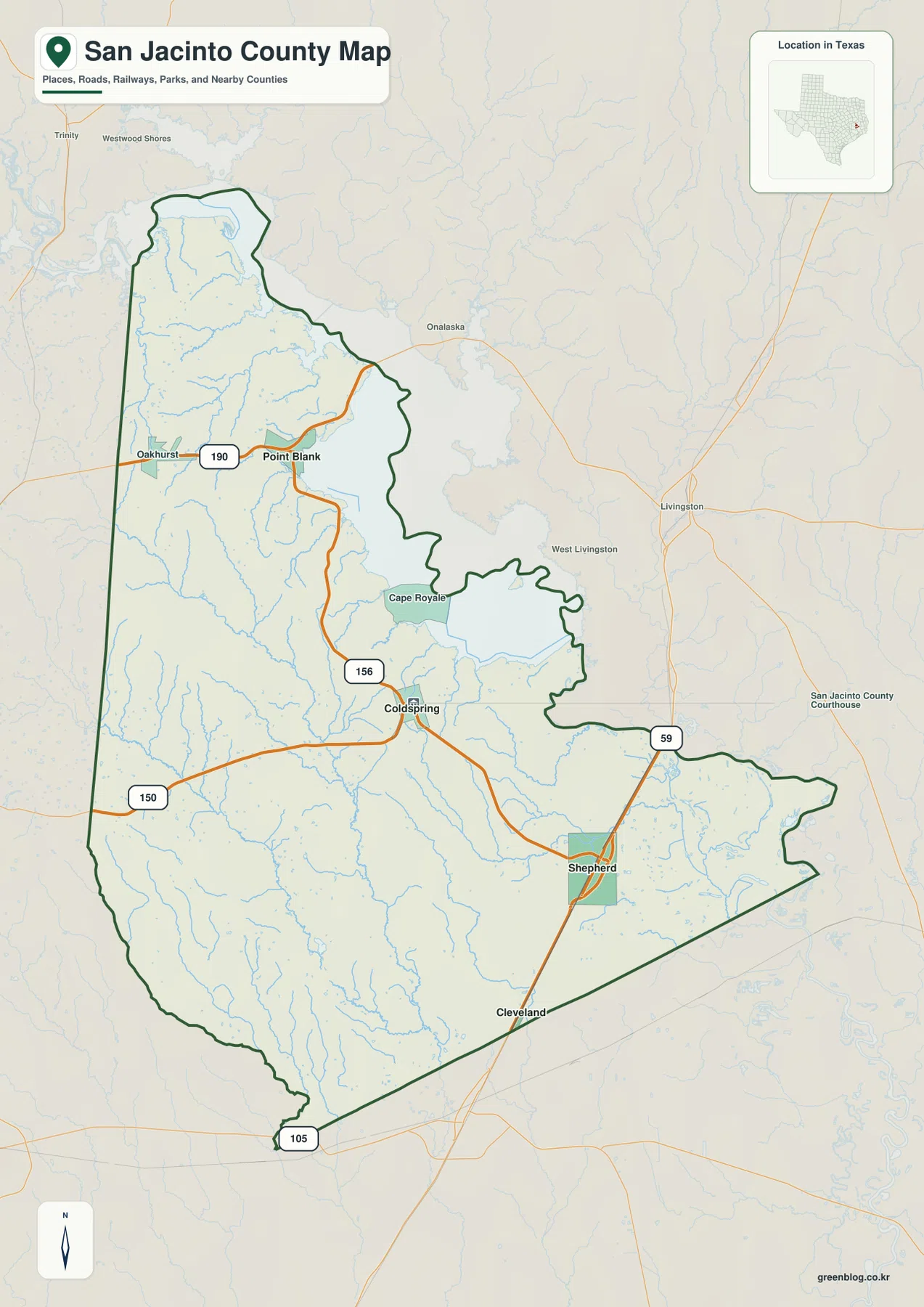
Several places outside the boundary help with orientation as well. Onalaska appears north of the county, while Livingston and West Livingston are shown east of the Lake Livingston side. Cleveland appears south of the boundary. These labels are useful because they put the county in a broader local setting without requiring a separate regional map. A reader can quickly see that Point Blank faces the lake side of the county, while Shepherd and Coldspring are positioned farther inland.
Shepherd works as a practical hub for comparing the mapped towns
The city-connections map uses Shepherd as the hub and gives straight-line distances to two other mapped places. Coldspring is shown about 10 miles from Shepherd, and Point Blank about 21 miles away. These are direct map distances, not driving distances, so a road trip between the same places can be longer depending on the route. The distinction is important because the purpose of this map is to compare location and separation, not to replace turn-by-turn navigation.
The three labels also reveal a clear north-south arrangement. Shepherd is in the southeast, Coldspring sits northwest of it near the middle of the county, and Point Blank is farther north. The map names Polk County to the north, Walker County to the east, Liberty and Trinity counties on the west side, and Montgomery County to the southwest. Those surrounding names make the city positions easier to understand because they show which neighboring county lies beyond each edge.
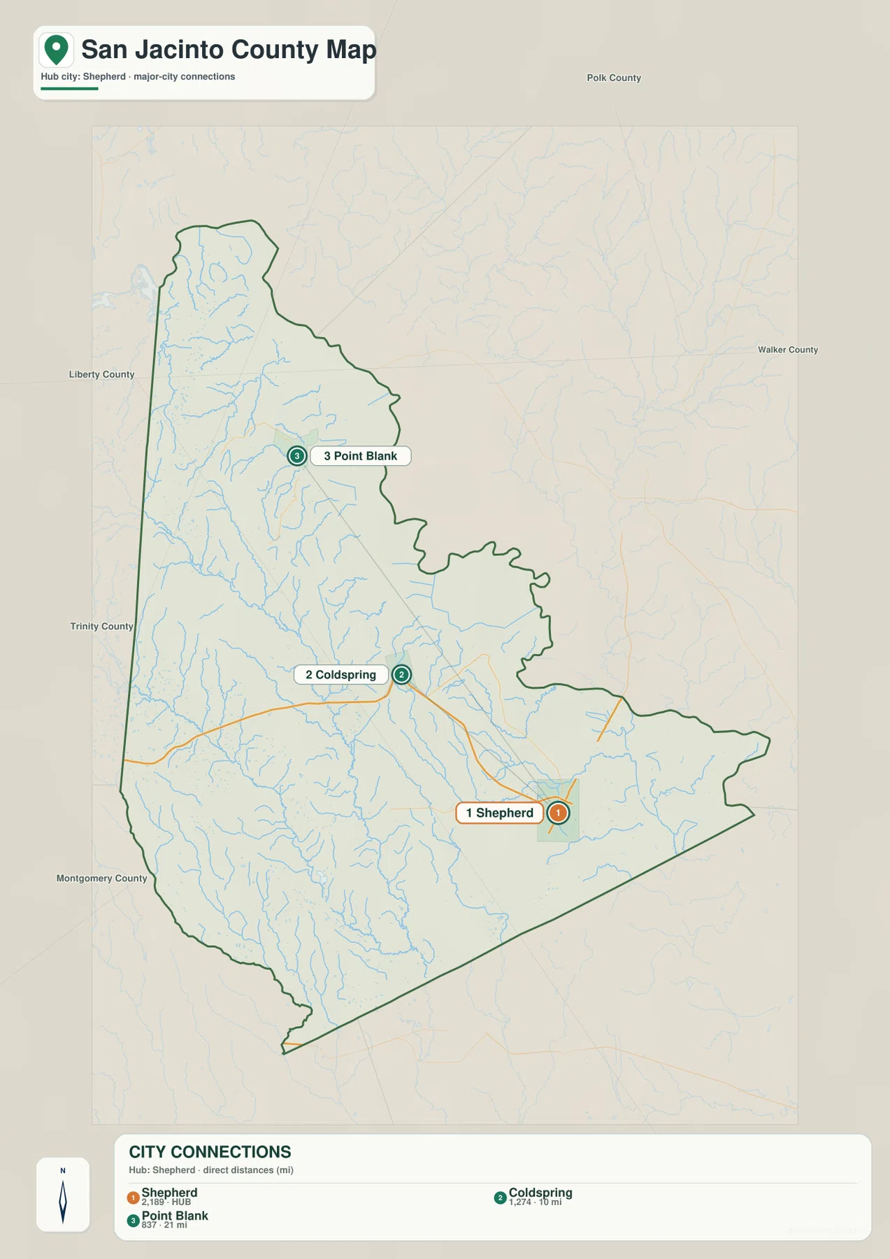
This simplified map is useful when a project needs the main place relationships without every route number. It still retains the county outline and water network in the background, so the cities are not separated from their geographic setting. Used beside the reference map, it becomes clear that Point Blank belongs to the Lake Livingston side, Coldspring is the inland county-seat reference, and Shepherd is the southeastern highway community.
Creeks, bayous, and two major river systems divide the interior
The terrain-and-water map shows a much denser drainage network than the road map suggests. The Lake Livingston area dominates the northeast. Pools Creek is labeled near the north, with Rocky Creek and smaller branches nearby. Pauline Creek is visible farther west. In the central-western part of the county, the East Fork San Jacinto River forms one of the strongest blue lines and continues south while collecting numerous small tributaries.
Miller Creek and Double Lake appear closer to the center, and Winters Bayou runs through the southwestern half. On the eastern side, the Trinity River is labeled along the broad water network. Huffman Creek and Big Creek cross the eastern interior, while Lake Water Wheel and Lake Tejas are marked in the southeast. The collection of named waters makes it clear that San Jacinto County is not defined by Lake Livingston alone; smaller creeks, bayous, ponds, and river channels are spread across nearly the entire county.
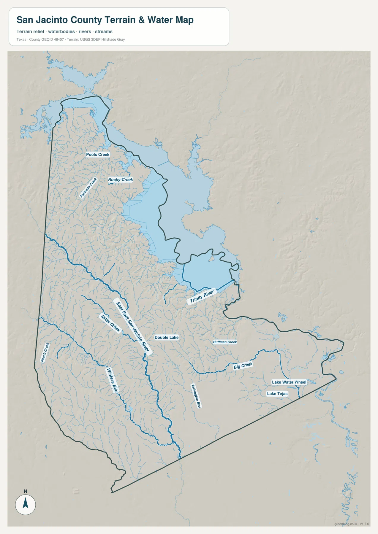
The water pattern is different on the two sides of the county. To the east, broad water and the Trinity River system help shape the county boundary itself. Farther west, narrow tributaries branch across the interior and feed the East Fork San Jacinto River and Winters Bayou. This difference is useful when trying to understand why the northeastern outline is so irregular while the western boundary remains comparatively simple.
Elevation falls from western ridges toward the eastern lowlands
The elevation map reports an actual range of about 13 to 132 meters, with a mean elevation of 66 meters. Brown and tan areas identify the higher terrain, and the strongest concentration of those colors appears in the west and southwest. The northwest also contains a series of higher ridges. In contrast, the Lake Livingston side and much of the eastern boundary are green, showing much lower ground.
The transition is not a single smooth slope. Numerous narrow green valleys cut between the western and central ridges, creating a branching texture that matches the creek network on the water map. As the terrain approaches the eastern water, the lower colors become broader and more continuous. Comparing the two maps makes the relationship easy to understand: many streams occupy the low corridors, while the higher ridges separate neighboring drainage paths.
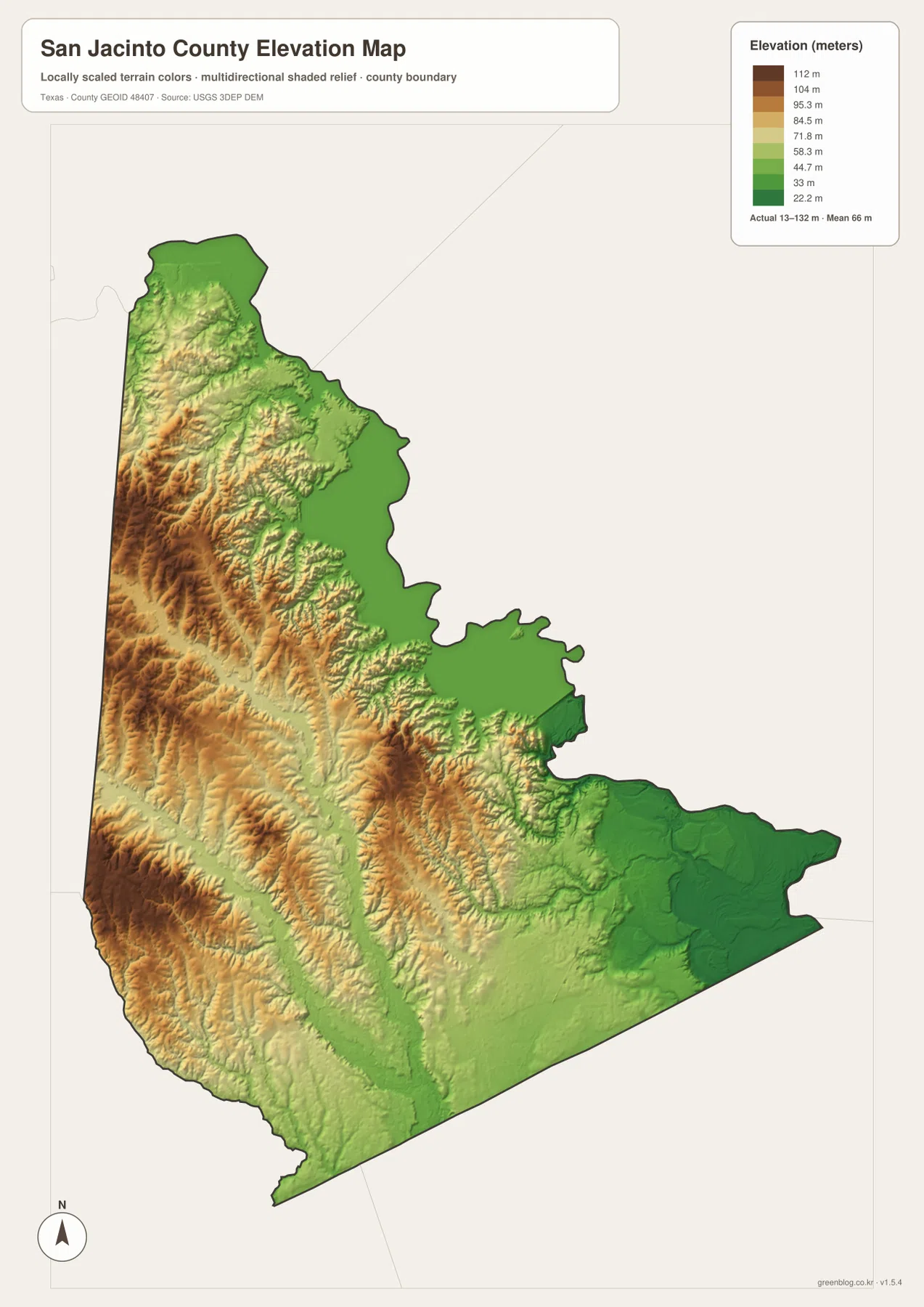
This generalized elevation surface is appropriate for comparing broad terrain differences, not for survey or engineering work. It shows where the county is relatively high or low and how valleys align with the mapped water network. A project that requires the exact elevation of a particular parcel or structure should use the underlying source data or a more detailed local survey rather than reading a precise value from this countywide image.
Matching Coldspring, Shepherd, and Point Blank to the right map
Choose the reference map when you need roads, the county outline, Coldspring, Shepherd, Point Blank, Oakhurst, and nearby regional places in one view. The city-connections map is better for a clean comparison of Shepherd, Coldspring, and Point Blank and for the straight-line distance labels. Use the water map when Lake Livingston, the Trinity River, East Fork San Jacinto River, Big Creek, or Winters Bayou is the main subject. The elevation map is the clearest option for comparing the western ridges with the eastern lowlands.
The WebP versions in the article are convenient for quick viewing. For printing or editing, the ZIP below contains the four matching maps as high-resolution A3 JPG files: county reference, city connections, terrain and water, and elevation. Keeping them as separate files makes it easy to select only the map needed for a classroom handout, local reference sheet, presentation, or personal project.
Frequently Asked Questions
Is Point Blank close to Lake Livingston?
Yes. On the supplied reference map, Point Blank is positioned in the northern part of the county close to the Lake Livingston shoreline. The city-connections map places it about 21 miles from Shepherd by straight-line distance.
Is the 10-mile Shepherd-to-Coldspring distance a driving distance?
No. The city-connections map explicitly presents direct distances from the Shepherd hub. Coldspring is labeled about 10 miles away in a straight line, so an actual road trip can be longer depending on the route used.
Which part of San Jacinto County is highest?
The elevation map places much of the higher terrain in the west and southwest, with additional ridges in the northwest. The eastern side near Lake Livingston is much lower. The map states an actual countywide range of about 13 to 132 meters and a mean of 66 meters.
Map File Information
The ZIP contains the four San Jacinto County maps in high-resolution A3 JPG format.
- Included Versions: County reference, city connections, terrain and water, elevation
- Included Files: 4 A3 JPG maps
Related Maps
Sources and data references
County boundaries and road reference data can be checked with the U.S. Census Bureau TIGER/Line Shapefiles. Rivers, creeks, and other hydrographic features can be cross-checked through USGS National Hydrography, and terrain data are available from the USGS 3D Elevation Program. Place positions, straight-line city distances, named waterways, and elevation figures described above are based on the San Jacinto County maps supplied in the current ZIP package.
Green Map creates custom-edited map images using open geographic data sources such as geoBoundaries, Natural Earth, OpenStreetMap, and government open data.
These maps are edited visual materials, not raw data files, and are provided for education, documents, presentations, and graphic reference.