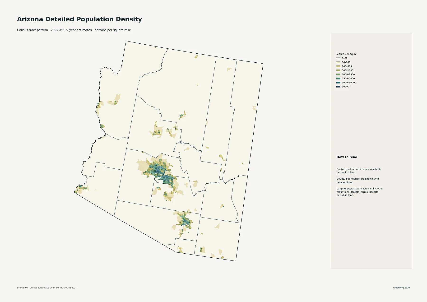
Clay County sits in northeastern Mississippi, with West Point close to the eastern side of the county and a much broader rural area extending west toward Pheba and Montpelier. The maps on this page show that contrast from several angles: roads converge around West Point, the Tombigbee River forms the strongest water reference along the east, numerous creeks cut through the interior, and the western ridges stand noticeably higher than the river-side lowlands. The WebP maps can be viewed on the page, and the file box below provides the matching high-resolution A3 JPG county, city, water, and elevation maps in one ZIP download.
This is not a county where one map tells the whole story. A road map makes West Point look like the obvious center of activity, but the city-index map also shows how far east that main city sits within the county outline. The water map adds the Tombigbee, Chuquatonchee, and Tibbee systems, while the elevation map shows a 49–160 meter range with the strongest relief in the west and northwest. Reading those features together gives a clearer picture of why the eastern and western halves of Clay County look so different.
Table of Contents
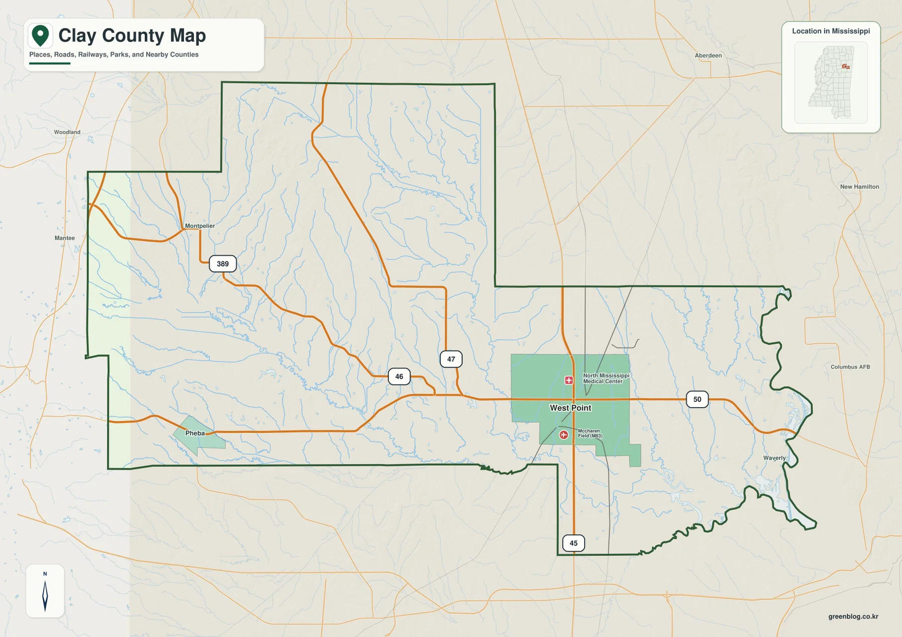
West Point and the road network on the eastern side
On the county reference map, West Point is the most prominent place and lies well east of the geometric center of Clay County. MS 50 runs east–west through the city and continues toward the Lowndes County side, while US 45 passes south of the main urban area on a north–south alignment. MS 47 approaches from the northwest and meets the east–west corridor near West Point. Those routes make the eastern side of the county much easier to recognize than the more dispersed road pattern farther west.
The western half is organized differently. MS 46 crosses the county from the Pheba side toward West Point, and MS 389 comes through the northwest near Montpelier before bending southeast. Smaller roads fill the gaps between the state routes, but the map does not show a second urban concentration comparable to West Point. This is useful when explaining Clay County because a reader can separate the major eastern hub from the long rural stretch that reaches toward the Webster and Oktibbeha County sides.
Several landmarks around West Point also help with orientation. The map labels North Mississippi Medical Center north of the urban core and McCharen Field farther south. These labels are location references only; the map is not intended to describe medical services, airport operations, or facility boundaries. For general map use, they simply provide additional fixed points near the city and the US 45/MS 50 road network.
Why the city map highlights only West Point
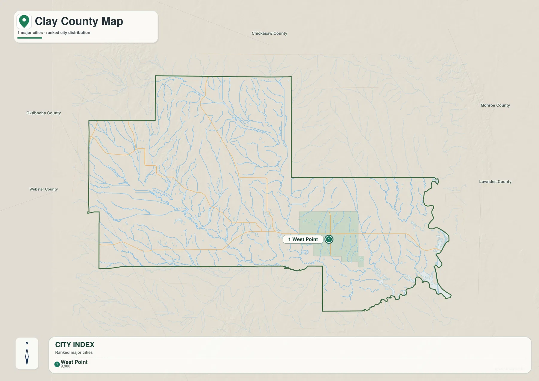
The city-index map simplifies the county dramatically. It identifies one major city, West Point, and places it near the eastern side of the outline. The index shows West Point with a value of about 9,900, making it the only ranked urban label on this version. That means the city map is best used to show where the county’s principal population center sits, not to catalog every community or compare several city-to-city distances.
The surrounding county labels make West Point’s position even clearer. Chickasaw County is shown to the north, Monroe County to the northeast, Lowndes County to the east, and Oktibbeha and Webster counties to the west and southwest. Because West Point is close to the Lowndes County side, a large part of Clay County extends westward behind it. This helps explain why the general map contains western place names such as Pheba and Montpelier even though the city-index map emphasizes only West Point.
The absence of those smaller labels from the city map should not be read as evidence that they do not exist or have no local importance. The map has simply been filtered to a major-city ranking. When a presentation needs a clean visual with one obvious reference point, this version works well. When the task is to discuss local roads, small communities, or the broad shape of the county, the fuller reference map is the better choice.
Tombigbee River, interior creeks, and small lakes
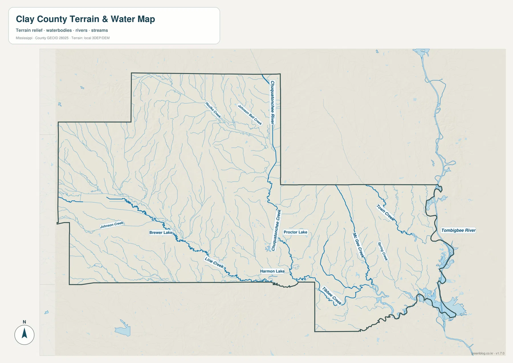
The water map changes the emphasis from roads to drainage. The Tombigbee River is the largest named water feature and follows the eastern edge of the county. Town Creek enters that eastern river corridor, while McGee Creek and Spring Creek run through the southeastern interior. These streams help show that the lower eastern terrain around the Tombigbee is connected to a much wider network of small tributaries rather than being a single isolated river channel.
Farther west and north, the Chuquatonchee system becomes more important. Chuquatonchee Creek runs through the central part of the county, and the Chuquatonchee River is labeled near the northern section. Houlka Creek and Johnson Bell Creek are shown in the same northern area. Along the south, Tibbee Creek forms another strong water reference, with Line Creek and other tributaries feeding the southern drainage. The result is a county map filled with narrow stream valleys even in places that look simple on the road map.
Several named lakes add smaller reference points. Brewer Lake appears in the western interior, Proctor Lake is closer to the center-east, and Harmon Lake lies near the southern boundary. Johnson Creek and other minor channels join the network around them. These features are helpful for locating water on a general terrain map, but this is not a flood-hazard, navigation, parcel, or depth map. For those purposes, a specialized official product would be required.
From western ridges to the lower Tombigbee side
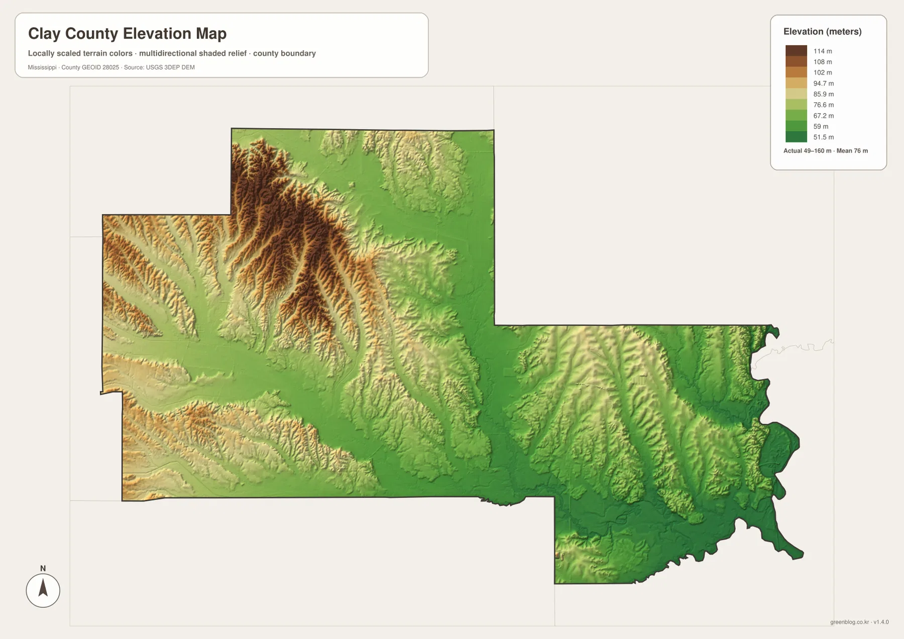
The elevation map reports an actual range of about 49 to 160 meters, with a mean near 76 meters. The highest colors are concentrated in the western and northwestern portions of Clay County, where narrow ridges repeat across the map. Similar ridge-and-valley texture continues into the central interior, although the colors become lower overall as the terrain approaches the eastern side.
Near West Point and especially toward the Tombigbee River, green tones cover a larger area. Those colors represent lower ground than the brown and yellow ridges in the west. The transition is not a smooth slope from one side to the other; small ridges and stream valleys interrupt it repeatedly. Still, the broad difference is clear enough that the eastern river corridor appears lower while the western half contains much stronger local relief.
This generalized elevation surface is useful for comparing county-scale terrain, but it should not be treated as a survey or engineering product. It cannot establish the exact elevation or slope of an individual property. Its strength is visual comparison: a reader can place the western ridges beside the lower Tombigbee side, then use the water map to see how creeks follow the lower valleys between those higher areas.
County facts and the Black Prairie setting around West Point
- County seat: West Point
- FIPS code: 28025
- 2020 census population: 18,636
- July 2025 population estimate: 18,238
- 2025 Gazetteer area: 410.011 sq mi land and 5.909 sq mi water
- 2020 land-area reference density: about 45.4 residents per sq mi
- Elevation-map range: about 49–160 m, mean about 76 m
The 2020 census count and the July 2025 population estimate refer to different dates and should not be treated as two measurements from the same year. The land and water figures are also listed separately. A countywide value of roughly 45.4 residents per square mile can be derived from the 2020 population and land area, but that number does not describe the actual density of West Point, Pheba, Montpelier, or any specific rural area.
The supplied background material places West Point within Mississippi’s Black Prairie, a regional setting associated with prairie soils and long-standing agricultural use. That context helps explain why Clay County is often described differently from more heavily forested uplands nearby. The maps on this page, however, are not land-cover or soil maps. They show roads, places, waterways, and terrain, so the Black Prairie reference should be used as geographic background rather than as a direct measurement of current farm acreage or vegetation.
West Point is both the county seat and the only major city highlighted on the city-index map, so the administrative center and the main urban reference coincide. West of the city, the county becomes much more rural and topographically varied, with smaller place labels, more pronounced ridges, and a dense stream network. East of West Point, the Tombigbee River and lower ground create a different landscape reference. That east–west contrast is one of the most useful themes to carry through the map set.
Choosing the right Clay County map file
Use the county reference map when you need West Point, Pheba, Montpelier, US 45, MS 46, MS 50, and the county outline on one page. Use the city-index version when the goal is a simple graphic showing West Point’s position within the county and the surrounding county names. For waterways such as the Tombigbee River, Chuquatonchee River, Tibbee Creek, or the named lakes, the water map is the clearest option. The elevation map is the best companion when you need to explain why the western side is more rugged and the river-side east is generally lower.
The on-page images are WebP previews intended for quick viewing. For printing, enlarging, or placing the maps into a presentation, use the ZIP below. It contains high-resolution A3 JPG versions corresponding to the county, city, water, and elevation maps shown here, so each file can be used separately or paired with another map when a comparison is useful.
Frequently Asked Questions
Is West Point near the center of Clay County?
No. Both the general map and the city-index map place West Point close to the eastern side of the county. A substantial part of Clay County extends west toward Pheba, Montpelier, and the Webster and Oktibbeha County sides.
Where is the Tombigbee River in relation to Clay County?
The water map shows the Tombigbee River along the eastern edge of the county. Town Creek and other waterways connect toward that corridor, and the elevation map shows generally lower terrain near the river than in the western ridges.
Which part of Clay County appears highest on the elevation map?
The strongest high-elevation colors occur in the west and northwest, with additional ridges extending through the central interior. The mapped actual range is about 49–160 meters and the mean is about 76 meters. The eastern Tombigbee side is generally lower.
Map File Information
Download high-resolution A3 JPG files showing West Point, major roads, the Tombigbee River drainage, and Clay County's elevation differences.
- Included Files: county map, city map, water map, elevation map
- File Type: JPG
Related Maps
Sources and References
- U.S. Census Bureau QuickFacts – Clay County
- U.S. Census Bureau Gazetteer Files
- USGS National Hydrography
- USGS 3D Elevation Program
- Mississippi Department of Transportation official highway map
- Mississippi Encyclopedia – Clay County
Green Map creates custom-edited map images using open geographic data sources such as geoBoundaries, Natural Earth, OpenStreetMap, and government open data. These maps are edited visual materials, not raw data files, and are provided for education, documents, presentations, and graphic reference.