Coahoma County sits in the Mississippi Delta, where the county’s western edge follows a series of broad Mississippi River bends while the interior spreads across low, nearly level ground. Clarksdale is the main road and settlement reference on the map: US 49 and US 61 pass through the area, MS 6 runs east-west near Lyon and Clarksdale, and MS 322 reaches west toward Farrell. The maps on this page also show Friars Point, Lula, Jonestown, Coahoma, Lyon, named lakes, the Sunflower river system, and the county’s small but visible elevation differences.
The WebP images are designed for quick viewing in the article, while the file box below provides an A3 high-resolution JPG ZIP for download. Use the county map when roads and smaller place names matter, the city map when you want a cleaner view of six ranked communities, the water map for Mississippi River bends and interior lakes and streams, and the elevation map for the roughly 37–63 m relief range. Looking at the set together is especially useful in Coahoma County because water and roads provide stronger geographic reference points than mountains or large changes in elevation.
Table of Contents
Clarksdale as the road reference for the county
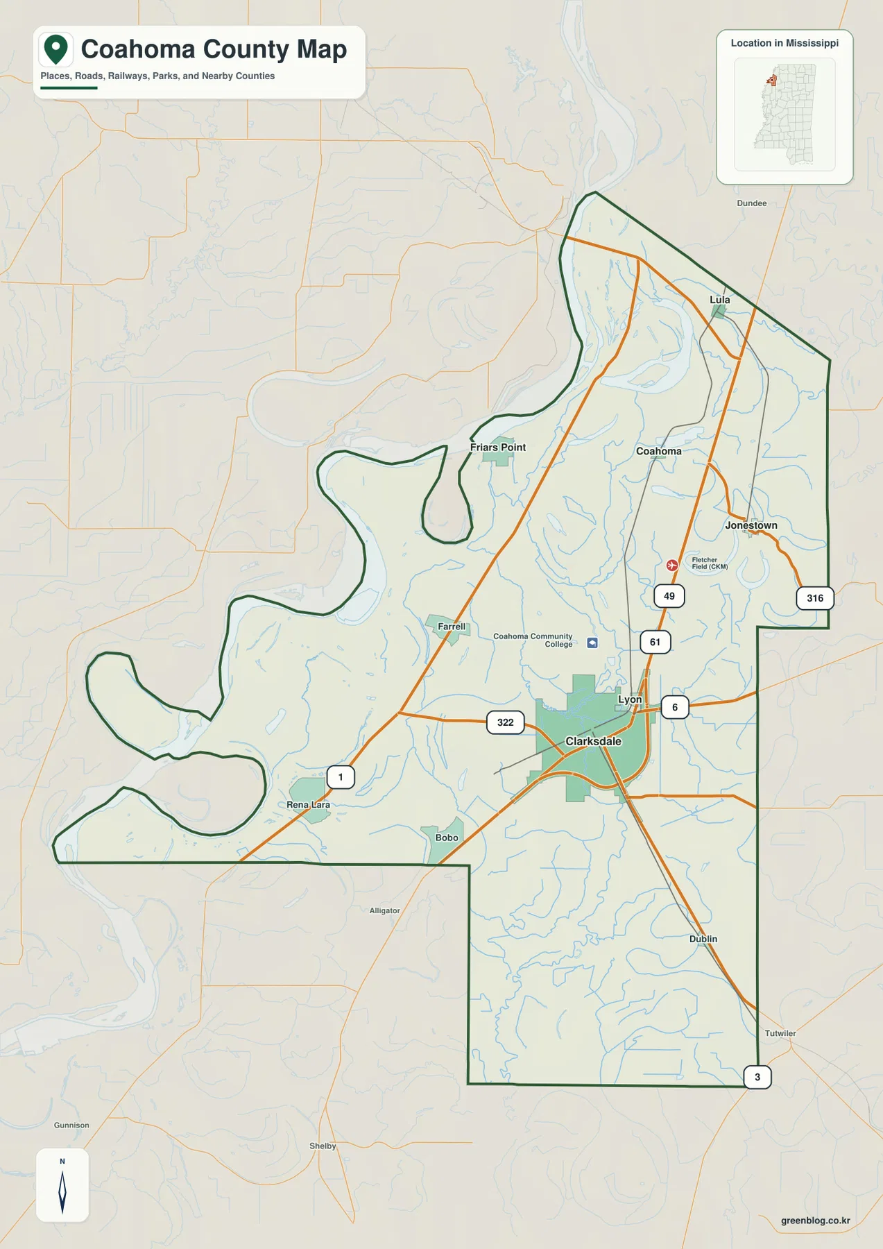
Clarksdale appears in the eastern half of Coahoma County and is the clearest starting point for reading the general map. US 49 and US 61 are marked just north of the city, while MS 6 crosses the county through Lyon and continues east. MS 322 runs west from the Clarksdale area toward Farrell, and MS 1 follows the river side of the county farther west. Together, these routes explain why Clarksdale functions as the most useful orientation point even though the county boundary extends far toward the Mississippi River.
North of Clarksdale, Lyon appears nearby before the map opens toward Coahoma and Lula. Jonestown lies to the east, close to MS 316, while Friars Point is separated from the Clarksdale area by a much wider stretch of Delta land and sits much closer to the river bends. Smaller labels such as Farrell, Rena Lara, Bobo, and Dublin remain visible on the general map, giving readers more detail than the simplified city index. On such flat terrain, the combination of roads and named communities is one of the easiest ways to judge direction and relative distance.
The map also marks Coahoma Community College and Fletcher Field as additional reference points in the Clarksdale-Lyon part of the county. They are useful as location markers, not as claims about current services or facility size. Labels outside the boundary help place the county within the surrounding Delta as well. This makes the general map useful for explaining how Clarksdale relates not only to river-side communities such as Friars Point, but also to the northern and eastern parts of the county.
What the six-community city index adds
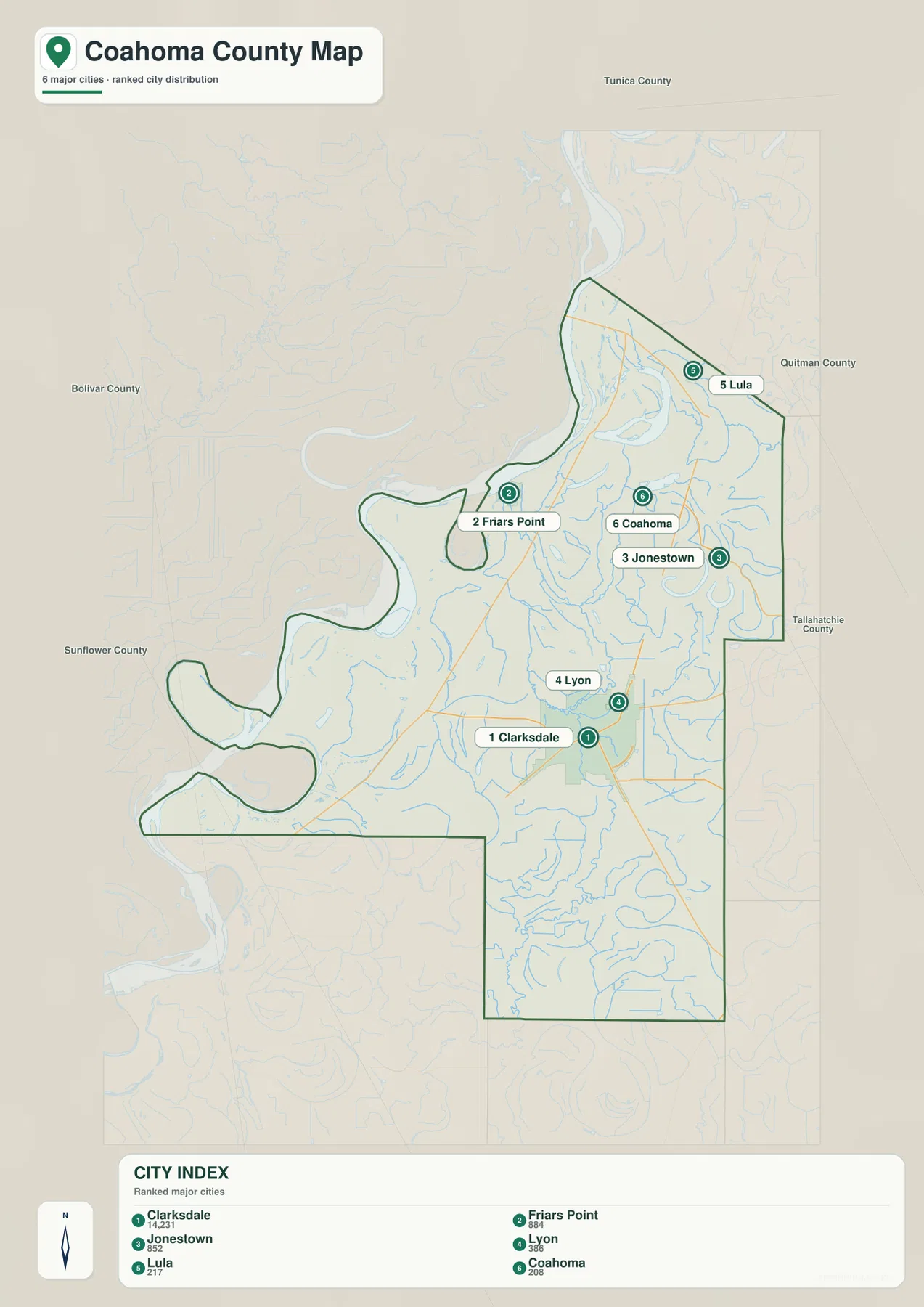
The city map removes most of the road detail and highlights six communities in a ranked index: Clarksdale, Friars Point, Jonestown, Lyon, Lula, and Coahoma. Clarksdale is shown as number 1, followed by Friars Point as 2, Jonestown as 3, Lyon as 4, Lula as 5, and Coahoma as 6. The ranking is a feature of this supplied map and is best used to distinguish the labeled communities quickly; it should not be treated as a statement about their legal municipal classification.
The placement of those six labels shows how unevenly the county’s settlements are distributed. Clarksdale and Lyon sit relatively close together in the southeast-central part of the mapped area. Friars Point is far to the west beside the Mississippi River side of the county, Lula is near the northeastern end, and Jonestown lies along the eastern side. Coahoma sits in the northern interior. That spread matters because there is no mountain range or major elevation break dividing the communities; location is better understood from roads, waterways, and the county’s unusual outline.
The city map and general map therefore answer different practical questions. If you need to show where the principal labeled communities sit in relation to the county boundary, the city map is uncluttered and easy to read. If you need to explain how someone would move between them, return to the general map for US 49, US 61, MS 1, MS 6, MS 316, and MS 322. The city index also helps prevent a common naming confusion: Coahoma County is the county as a whole, while Coahoma is also a separately labeled community within it.
Mississippi River bends, Moon Lake, and the Sunflower waterways
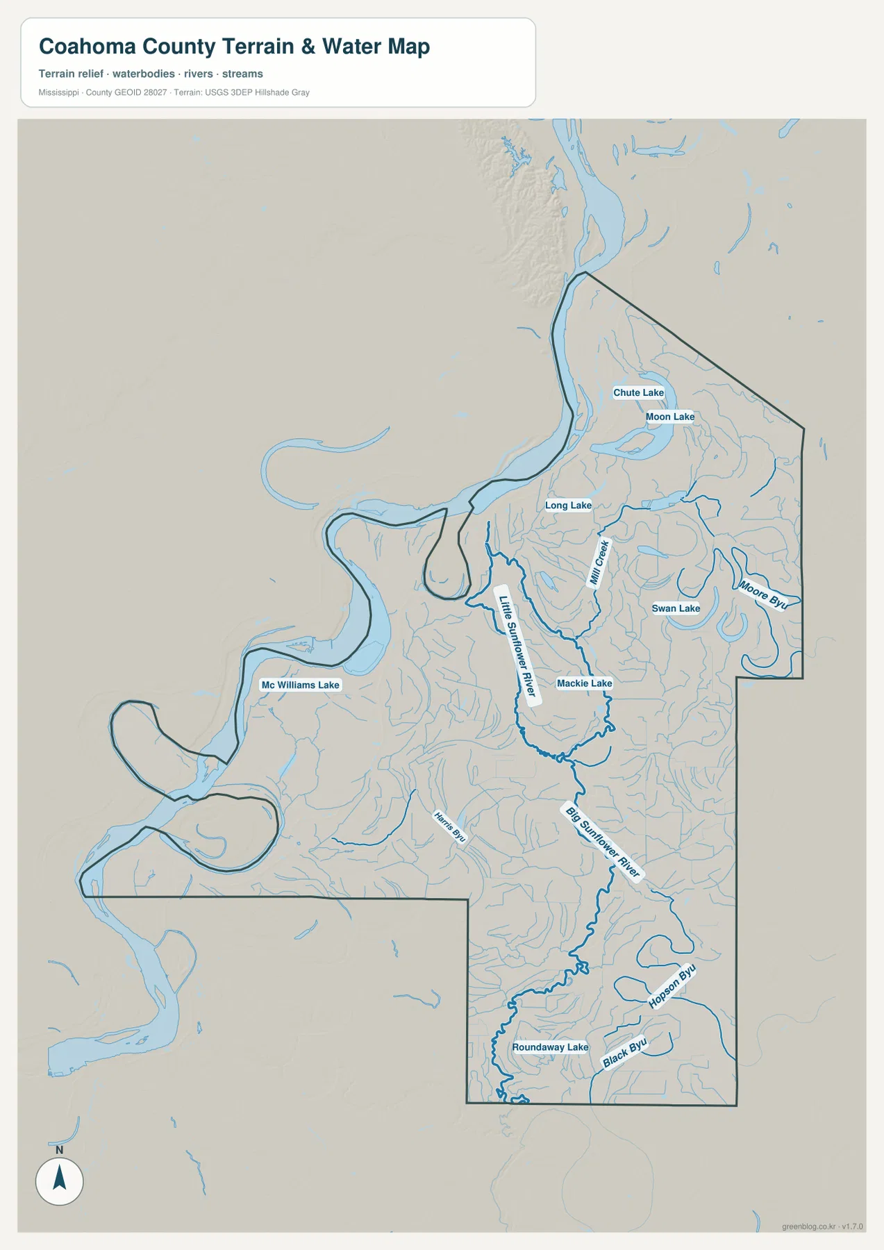
The terrain and water map makes the western boundary immediately distinctive. Instead of a straight county line, the edge follows broad Mississippi River bends that curve in and out several times. Mc Williams Lake is labeled near the western side, while Chute Lake and Moon Lake appear farther north and Long Lake lies below them. These named water bodies make it easier to see that the river side of Coahoma County is not a simple line on a map; it is a landscape of bends, former channels, lakes, and low floodplain ground.
Inside the county, the Little Sunflower River is labeled through the northern and central area before the Big Sunflower River becomes the stronger southward watercourse. Mill Creek, Swan Lake, and Mackie Lake are shown nearby, and Roundaway Lake appears in the southern part of the map. A dense network of smaller streams and bayous fills the spaces between these named features. This is why the water map is much more informative than the general road map when the goal is to explain the county’s drainage and lake distribution.
This layer is a location reference, not a flood-risk, levee-safety, depth, parcel, or navigation map. It is appropriate for finding Moon Lake, comparing the Mississippi River side with the interior Sunflower system, or showing how many smaller channels cross the Delta. It should not be used to decide whether a property floods or whether a waterway is suitable for boating. For ordinary geographic explanation, however, the combination of river bends, lakes, and interior streams is one of the most county-specific parts of the entire map set.
A 37–63 m elevation range across the low Delta
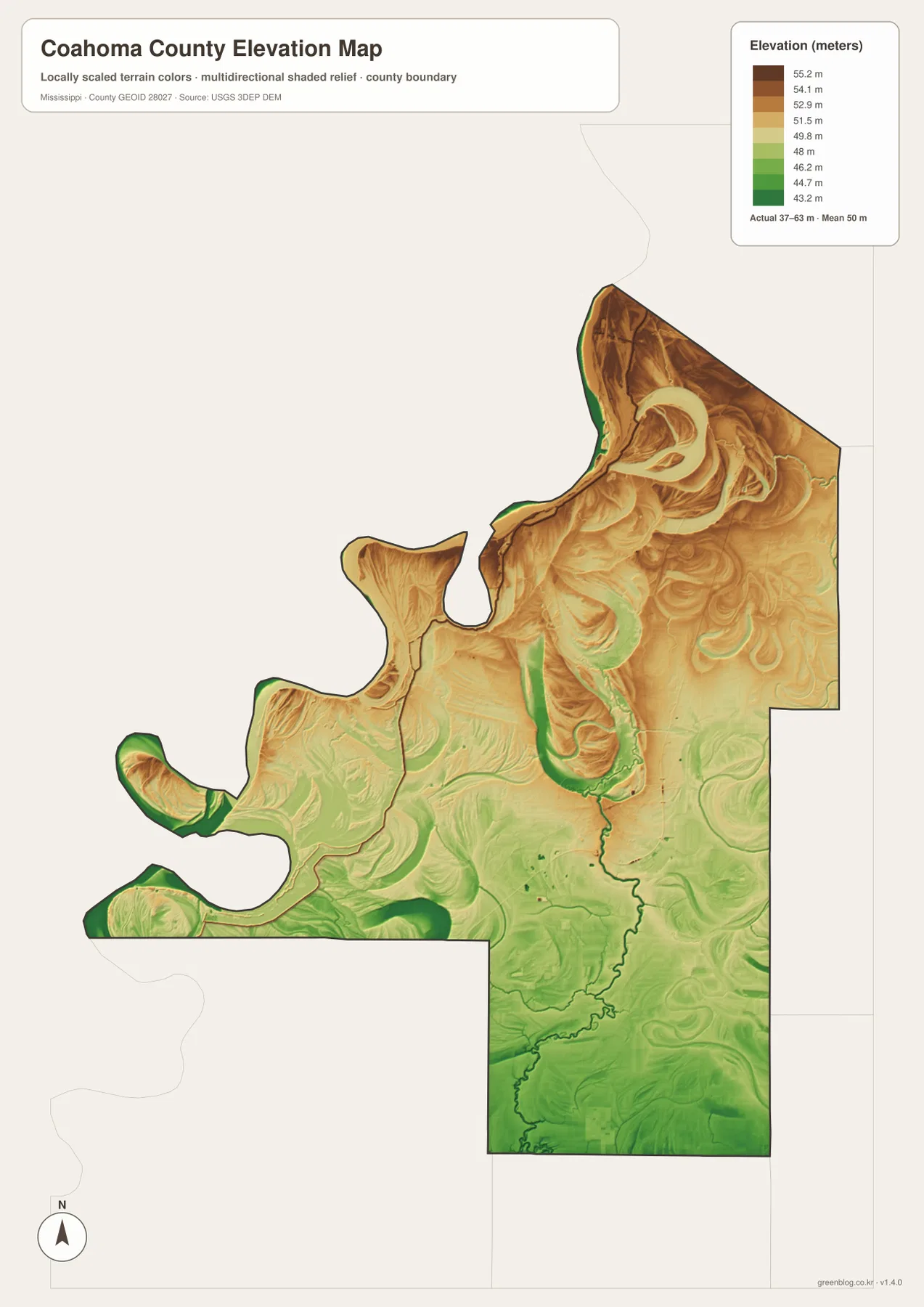
The elevation map gives an actual county range of about 37 to 63 meters, with a mean near 50 meters. That is a narrow range compared with a hilly or mountainous county, but the shading still reveals clear local differences. Browns and tans are more common across the northern and northeastern part of the county, while greens spread across much of the south and along several river and channel corridors. The result is a map of subtle relief rather than dramatic slopes.
Along the Mississippi River side, green low areas appear around several bends, while curved higher and lower traces are visible across the northern interior. Farther south, lower green tones become more continuous. When the elevation layer is compared with the water map, many low corridors line up with the major rivers, lakes, and smaller drainage features. This does not mean every green strip is an active channel, but it helps explain why waterways are such strong visual guides in a county where the total relief is only a few dozen meters.
The elevation surface is generalized for county-scale comparison. It is not survey-grade data for a building site, drainage project, engineering design, or parcel boundary. Its best use on this page is to show that “flat Delta” does not mean perfectly level ground: the northern half contains relatively higher surfaces, while lower areas are widespread in the south and around waterways. That small difference is enough to make the elevation map useful when it is paired with the water layer.
County facts to keep beside the maps
- County seat: Clarksdale
- FIPS code: 28027
- 2020 Census population: 21,390
- July 2025 population estimate: 19,849
- 2025 Gazetteer area: 553.102 sq mi land and 29.933 sq mi water
- Elevation-map range: about 37–63 m, mean about 50 m
The 2020 Census count and the July 2025 estimate refer to different dates, so they should be read as separate snapshots rather than as values measured at the same time. The Gazetteer also separates land and water area, which is particularly useful here because the county contains prominent river bends, lakes, and smaller waterways. These figures add background to the maps, but they do not show where residents are concentrated within Clarksdale, smaller communities, farms, or other parts of the county.
The supplied source material also describes Clarksdale as a place strongly associated with cotton and rail commerce and with the history of Delta blues. These maps are not heritage-site guides, but they provide the geographic setting for that history: the road junction at Clarksdale, the river-side position of Friars Point, the scattered northern communities, and the waterways running through the agricultural Delta. For a trip focused on music sites or historic buildings, use this county map for regional orientation and a dedicated local guide for individual destinations.
Choosing the map that fits the question
Use the general county map when you need Clarksdale, Friars Point, Lula, Jonestown, smaller labels, and the main highways on the same page. Use the city map when the goal is simply to compare the six ranked communities without road clutter. The water map is the stronger choice for Mississippi River bends, Moon Lake, the Little and Big Sunflower rivers, and the network of smaller channels. The elevation map adds the final piece when you need to explain how a county that appears flat can still contain a measurable north-to-south and waterway-related difference in height.
For printing, enlargement, or use in a presentation, the downloadable ZIP contains A3 high-resolution JPG versions corresponding to the county, city, water, and elevation maps shown on this page. The WebP versions in the article are convenient for quick viewing, while the JPG files preserve a larger format for offline use. The download box below contains a single ZIP link so the four matching files can be saved together.
Frequently Asked Questions
Why is the western edge of Coahoma County so irregular?
The general and water maps show the western edge following broad Mississippi River bends, so the boundary curves in and out rather than forming a straight line. The maps are useful for seeing that relationship, but they are not legal parcel surveys or a history of channel changes.
Is Coahoma both the county name and the name of a community?
Yes. Coahoma County is the county as a whole, while the city-index map also labels a community named Coahoma in the northern interior. Clarksdale is farther south and is the county seat, so the two labels should not be treated as the same place.
Is the entire county at the same elevation because it is in the Delta?
No. The elevation map gives an actual range of roughly 37–63 m and a mean near 50 m. The difference is modest, but the northern part contains more relatively high tan and brown surfaces while lower green areas are widespread in the south and along water corridors.
Map File Information
Download A3 high-resolution JPG files covering the Clarksdale road network, Mississippi River and Delta waterways, and the county's 37–63 m elevation range.
- Included Files: County map, city map, water map, elevation map
- File Type: JPG
Related Maps
Sources and References
- U.S. Census Bureau QuickFacts – Coahoma County
- U.S. Census Bureau Gazetteer Files
- USGS National Hydrography
- USGS 3D Elevation Program
- Mississippi Department of Transportation official highway map
- Mississippi Encyclopedia – Coahoma County
Green Map creates custom-edited map images using open geographic data sources such as geoBoundaries, Natural Earth, OpenStreetMap, and government open data. These maps are edited visual materials, not raw data files, and are provided for education, documents, presentations, and graphic reference.