Copiah County stretches well beyond the north–south highway corridor that links Crystal Springs, Hazlehurst, and Wesson. The main county map makes that contrast easy to see: I-55 and US 51 form a strong central reference, while Georgetown sits far to the east and a broad network of smaller roads and streams fills the interior.
This page separates four useful views of the same county so the geography is easier to follow. The WebP images are page previews, and the map file box below provides a ZIP with the matching high-resolution JPG files for printing or personal editing. The maps are most useful when roads, town locations, waterways, and elevation are considered together rather than as isolated layers.
Two features stand out quickly. First, the populated corridor from Crystal Springs through Hazlehurst continues south toward Wesson and Beauregard, but it does not represent the whole county. Second, Copiah’s terrain is strongly dissected: the elevation surface spans about 37 to 168 meters, while Copiah Creek, Bayou Pierre, and many smaller channels occupy lower corridors between hills.
Table of Contents
A strong I-55 corridor inside a much wider county
The county reference map places Crystal Springs in the north, Hazlehurst near the middle, and Wesson and Beauregard near the southern edge. Georgetown is separated from that line of towns on the eastern side. This arrangement matters because a visitor who follows only I-55 or US 51 would miss a large share of the county’s east–west extent.
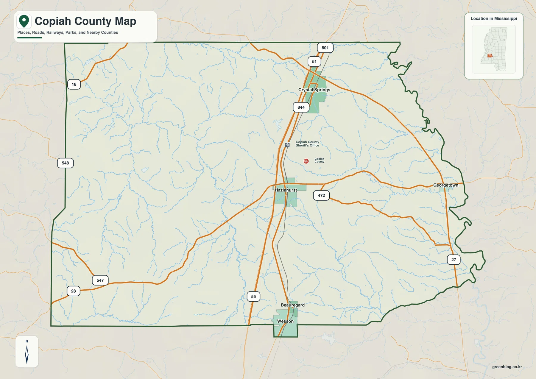
North–south travel is organized around I-55 and US 51, while several numbered routes reach into the eastern and western parts of the county. The map labels Route 472 east of Hazlehurst, Route 27 near the eastern boundary, Routes 28 and 547 in the southwest, and Routes 18 and 548 on the west side. These roads help explain why Georgetown and the western rural areas should not be treated as simple extensions of the interstate towns.
Hazlehurst is the county seat, and the county identifier is FIPS 28029. The supplied reference material lists a 2020 census population of 28,368 and a July 2025 estimate of 27,497. The 2025 Gazetteer values are 777.285 square miles of land and 2.179 square miles of water. Because the population figures come from different dates, they are best read as separate reference points rather than as one combined statistic.
The town pattern runs north to south, then breaks east
The city-distribution view simplifies the map to five ranked places: Crystal Springs, Hazlehurst, Wesson, Beauregard, and Georgetown. Crystal Springs and Hazlehurst form the two most prominent points on the central corridor. Wesson and Beauregard extend that pattern to the south, but Georgetown stands apart to the east, giving the county a noticeably uneven settlement pattern.
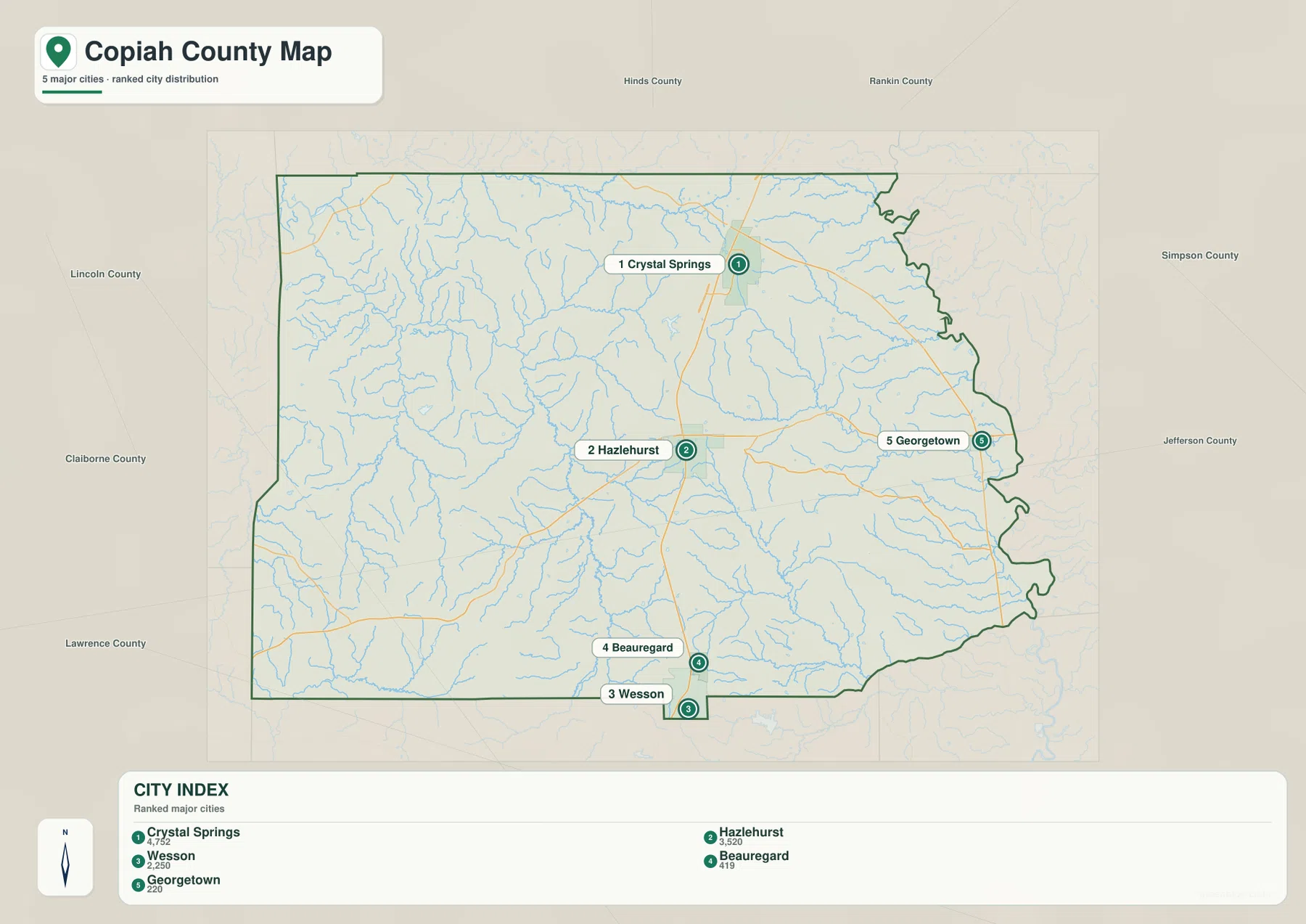
This map is useful for comparing location rather than road mileage. It does not draw straight-line connectors or claim travel distances; instead, the numbered city markers show where the main places sit inside the boundary. Wesson and Beauregard are close to the southern edge, while Georgetown is near the irregular eastern side of the county. The separation is clear even before individual road names are considered.
The surrounding county labels add another useful frame. Hinds and Rankin counties lie to the north, Simpson and Jefferson are on the eastern side, and Claiborne, Lincoln, and Lawrence appear around the west and southwest. Those neighbors show why Copiah functions as an interior Mississippi county with routes extending in several directions rather than one narrow commuter corridor.
Copiah Creek, Bayou Pierre, and a dense network of smaller channels
The water-and-terrain map is much more intricate than the road map. Copiah Creek crosses the central and eastern part of the county, while Bayou Pierre runs through the central-western area toward the south. White Oak Creek and Turkey Creek are labeled in the north, Bahala Creek appears in the southeast, and the Pearl River provides an important reference along the eastern side. The Homochitto River is labeled at the southwest edge.
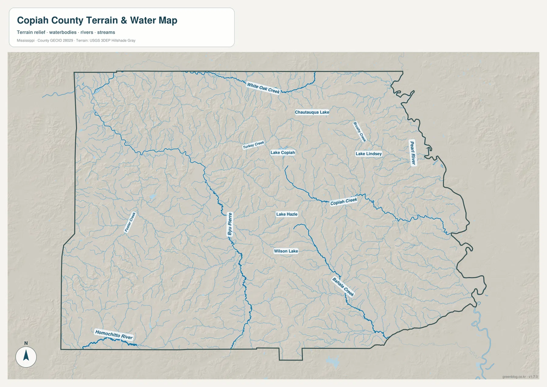
Several named lakes are distributed through the interior. Chautauqua Lake and Lake Lindsey sit toward the northeast, Lake Copiah is farther west, and Lake Hazle and Wilson Lake provide central and southern reference points. Their value on this map is not their size alone; together with the small tributaries, they make the drainage pattern easier to follow across the hilly surface.
This is a reference map of waterways and terrain. It should not be used as a flood-hazard map, parcel map, navigation chart, or legal water-boundary document. Questions involving flood risk, property limits, or engineering design require current information from the appropriate public agency.
Relief from about 37 to 168 meters reshapes the county
The elevation map gives an actual range of roughly 37 to 168 meters and a mean near 102 meters. Higher ridges appear in brown and tan, while lower valleys are green. The central and eastern interior contains many prominent ridges, and another high area is visible in the southwest. Lower corridors wind between them and often correspond to the same stream network shown on the water map.
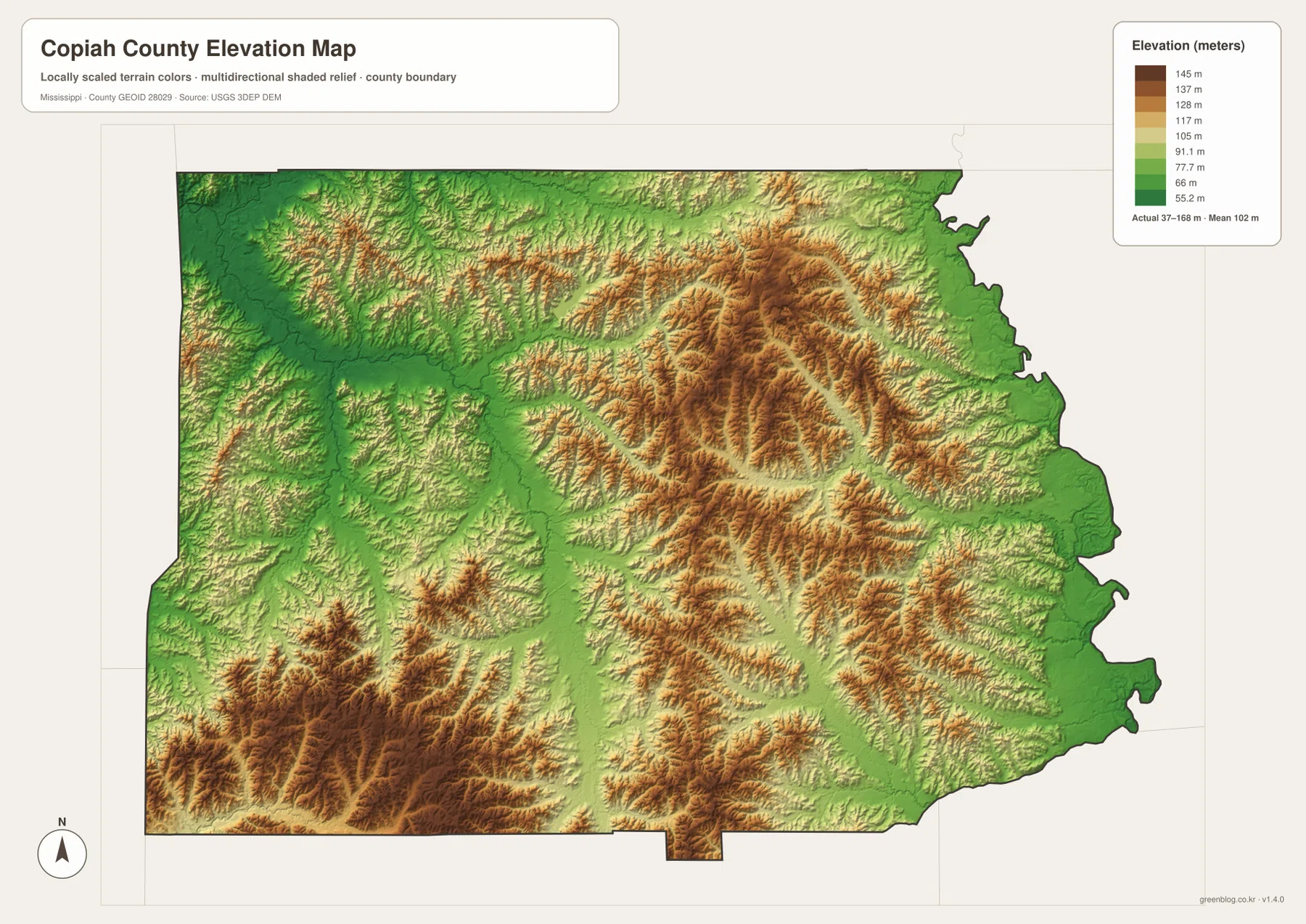
Comparing this map with the water view is especially helpful. Long green valleys cut through the higher ground, and branching tributaries occupy many of those lower routes. The pattern helps explain why rural travel can follow curving local roads even when two points look close on a county-wide map. Roads must connect settlements across a landscape of repeated ridges and drainage corridors.
The elevation surface is designed for county-scale comparison, not survey-grade measurement. It can show where the higher and lower parts of Copiah County are located, but it should not be used to assign a precise elevation to a parcel, building, or construction site.
Crystal Springs and Hazlehurst explain only part of the story
Crystal Springs is historically associated with rail-based vegetable shipping and tomato production, while Hazlehurst developed as the county’s governmental and transportation center. Their proximity on the same broad north–south corridor makes them useful reference points for the county’s population and transportation history. The maps, however, also show why that pair should not be allowed to stand for the whole county.
East of Hazlehurst, roads continue toward Georgetown and the Pearl River side of the county. West and southwest of the interstate, smaller roads cross a deeply divided network of hills and streams. Looking at the town map, water map, and elevation map together therefore gives a more complete picture than simply describing Copiah as an I-55 county.
Choose the map by the question you need to answer
The county reference map is the best starting point for towns, roads, and the overall boundary. The city map is cleaner when the goal is to compare the placement of the five ranked communities. The water map is better for following Copiah Creek, Bayou Pierre, the Pearl River side, and named lakes, while the elevation map is the clearest choice for comparing ridges with lower stream valleys.
- General orientation: use the county map for Crystal Springs, Hazlehurst, Wesson, Georgetown, major routes, and the boundary.
- Town distribution: use the city view to compare the north–south corridor with Georgetown on the east side.
- Water features: use the water map for Copiah Creek, Bayou Pierre, Pearl River references, tributaries, and named lakes.
- Terrain: use the elevation view to compare the 37–168 m relief range and lower drainage corridors.
If you need the original map files rather than the page previews, use the file box below. The ZIP contains the high-resolution JPG versions that correspond to the county, city, water, and elevation maps discussed on this page.
Frequently Asked Questions
Are Crystal Springs and Hazlehurst the same city?
No. They are separate cities on the same broad I-55 and US 51 corridor. Crystal Springs is north of Hazlehurst, and Hazlehurst is the Copiah County seat.
Why does Georgetown matter when reading the county map?
Georgetown provides a clear eastern reference point. It shows how far the county extends away from the Crystal Springs–Hazlehurst corridor and helps visitors compare the interstate side with the roads and waterways near the eastern boundary.
What does the 37–168 m elevation range tell me?
It shows that Copiah County contains meaningful local relief rather than one uniformly flat surface. Higher ridges and lower stream valleys repeat across the county, with a mean elevation near 102 meters. The map is useful for broad terrain comparison, not precise site measurement.
Map File Information
This ZIP contains the high-resolution JPG originals for the Copiah County county, city, water, and elevation maps shown on this page.
- Included Files: JPG originals corresponding to the four body maps
- File Type: ZIP containing JPG files
Related Maps
Sources and References
- U.S. Census Bureau QuickFacts – Copiah County
- U.S. Census Bureau Gazetteer Files
- Mississippi Encyclopedia – Copiah County
- Mississippi Department of Transportation official highway map
- USGS National Hydrography
- USGS 3D Elevation Program
Green Map creates custom-edited map images using open geographic data sources such as geoBoundaries, Natural Earth, OpenStreetMap, and government open data. These maps are edited visual materials, not raw data files, and are provided for education, documents, presentations, and graphic reference.