Covington County in south-central Mississippi is easiest to understand from Collins, the county seat near the middle of the map. Mount Olive sits to the northwest, Seminary lies to the southeast, and a web of state routes spreads east and west from the US 49 and US 84 area. The maps on this page also show a county crossed by Okatoma Creek, smaller tributaries, scattered lakes, and rolling ground rather than a flat plain. High-resolution JPG versions of the maps are available in one downloadable ZIP for printing, presentations, and offline reference.
The city-connection map adds a useful scale to those locations. It marks Mount Olive about 9 miles from Collins and Seminary about 7 miles from Collins, measured as straight-line distances. Those figures are not driving distances, but they quickly show how the three principal labeled communities are arranged within the county. The general map, water map, and elevation map then add roads, streams, lakes, and relief to that basic picture.
Table of Contents
Collins at the center of the county road network
On the county map, Collins is the clearest reference point. US 49 runs through the city and continues toward Mount Olive to the northwest and Seminary to the southeast. US 84 crosses the county from west to east and meets the Collins area, making the city a convenient place to orient the rest of the map. MS 35 appears on the western side, while MS 37 and routes such as 532 and 588 serve the eastern half. Farther south, route numbers 535, 589, 590, and 598 help trace connections around Seminary and the narrower southern part of the county.
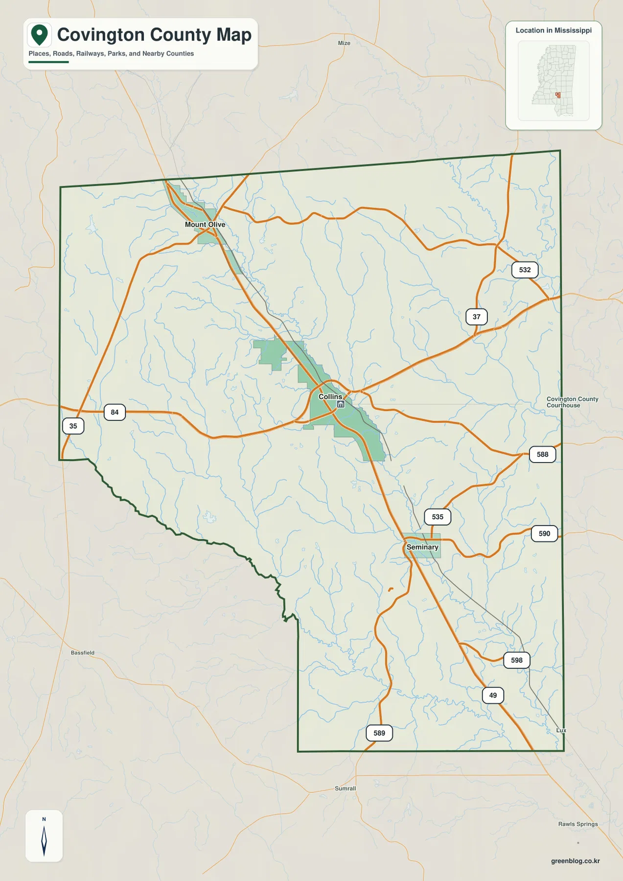
The shape of Covington County is also distinctive. Its northern portion is broad, while the western boundary bends inward farther south and creates a narrower southern section. Neighboring labels around the map include Jefferson Davis, Smith, Jones, Forrest, Marion, Simpson, and Lamar counties. Places shown outside the boundary, such as Bassfield, Sumrall, and Lux, provide orientation but should not be mistaken for communities inside Covington County.
The 2020 census counted 18,340 residents in Covington County, while the July 2025 estimate is 17,898. The 2025 Gazetteer lists 413.819 square miles of land and 1.112 square miles of water. Those figures describe the county at a broad statistical level. The maps reveal something different: settlement and roads are not spread evenly, with the Collins area standing out more strongly than much of the surrounding rural landscape.
Mount Olive and Seminary show the county beyond Collins
The city map strips away many minor labels and emphasizes three communities: Collins, Mount Olive, and Seminary. Collins is marked as the hub, Mount Olive appears northwest of it, and Seminary appears southeast. The map gives a straight-line distance of about 9 miles from Collins to Mount Olive and about 7 miles from Collins to Seminary. Because the measurement is direct rather than along a road, it is best used for comparing position and separation rather than planning a drive.
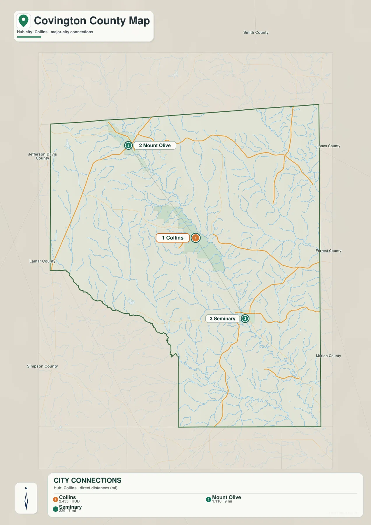
Placed beside the road map, the three-community layout becomes more informative. Mount Olive is aligned with the US 49 route heading toward the northwestern corner. Seminary sits on the same broad north-south route southeast of Collins, where additional local roads spread toward the eastern and southern parts of the county. This makes Collins the strongest central reference without implying that every local trip begins or ends there.
For a presentation or classroom map, the distance labels can be useful if they are described precisely. A note such as “approximately 9 miles straight-line from Collins to Mount Olive and 7 miles straight-line from Collins to Seminary” preserves what the map actually measures. Anyone who needs travel time or road mileage should check a current routing service separately.
Okatoma Creek, Leaf River, and a dense network of tributaries
The water map shows why Covington County cannot be understood from highways alone. Okatoma Creek is a major named stream running through the central part of the county. To the west, Dry Creek and Terrible Creek add smaller drainage lines. East of the center, Station Creek and Oakey Woods Creek are labeled, and the Leaf River appears along the eastern side. Bowie Creek crosses the southern portion and stands out as another named waterway in the narrower end of the county.
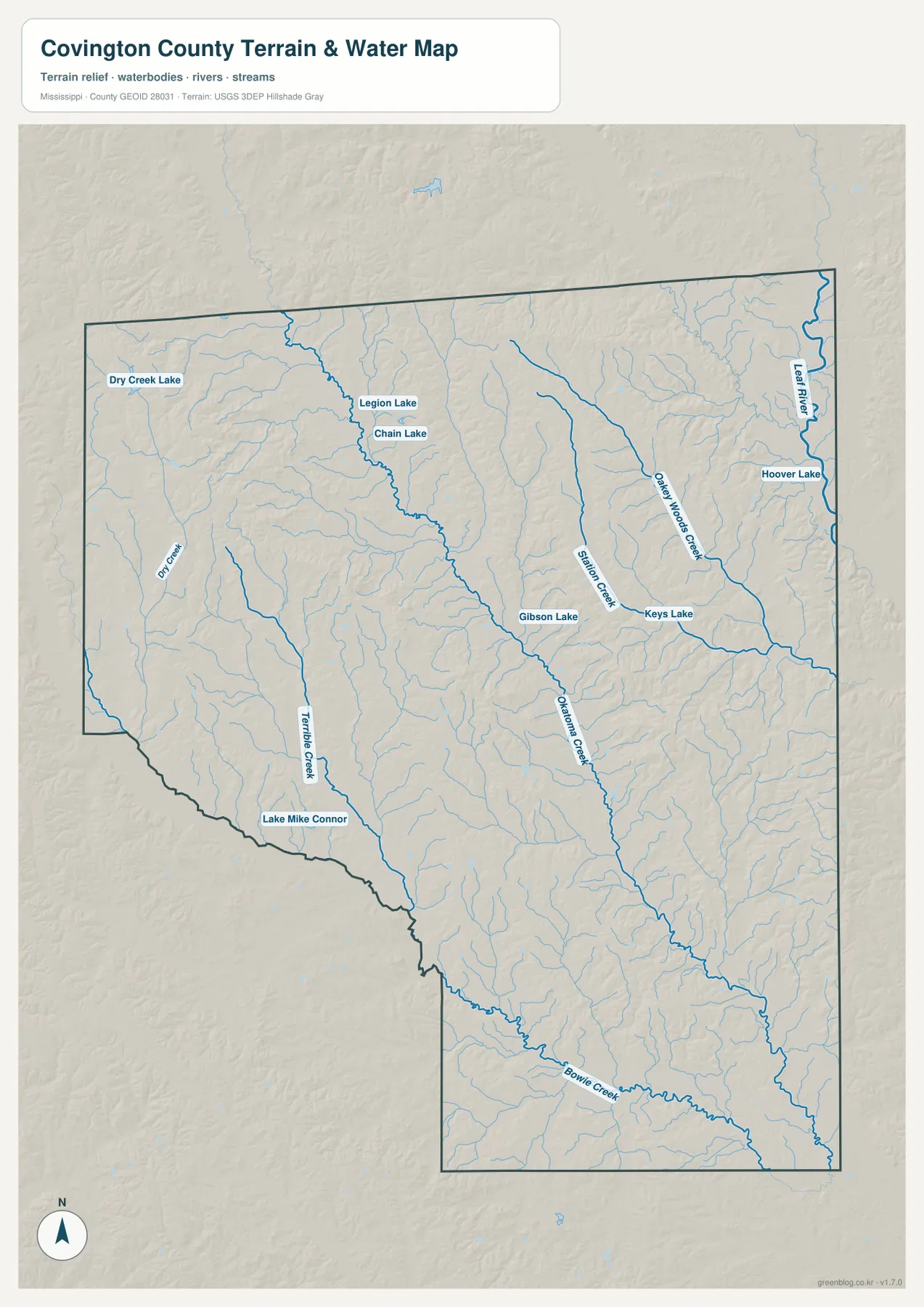
Several lakes are labeled as well. Dry Creek Lake lies in the northwest, while Legion Lake and Chain Lake appear closer to the north-central part of the county. Gibson Lake and Keys Lake are near the middle, Hoover Lake is toward the east, and Lake Mike Connor is shown in the southwest. These labels make the water map useful when a reader needs to distinguish a named lake from the much more numerous small stream branches visible in the background.
This is a reference map of visible waterways and terrain, not a flood-risk, property-boundary, depth, or navigation map. Okatoma Creek is prominent, but it is not the county boundary as a whole. The network of smaller streams follows lower ground between ridges, which becomes especially clear when the water map is compared with the elevation map.
Rolling relief from about 50 to 166 meters
The elevation map gives Covington County an actual range of about 50 to 166 meters, with a mean near 103 meters. The higher colors are concentrated most strongly across the northwestern and northern uplands, where narrow valleys cut through more elevated ground. Lower green areas follow major creek valleys through the center and extend across much of the southern portion. The eastern side also contains alternating ridges and low stream corridors rather than one uniform surface.
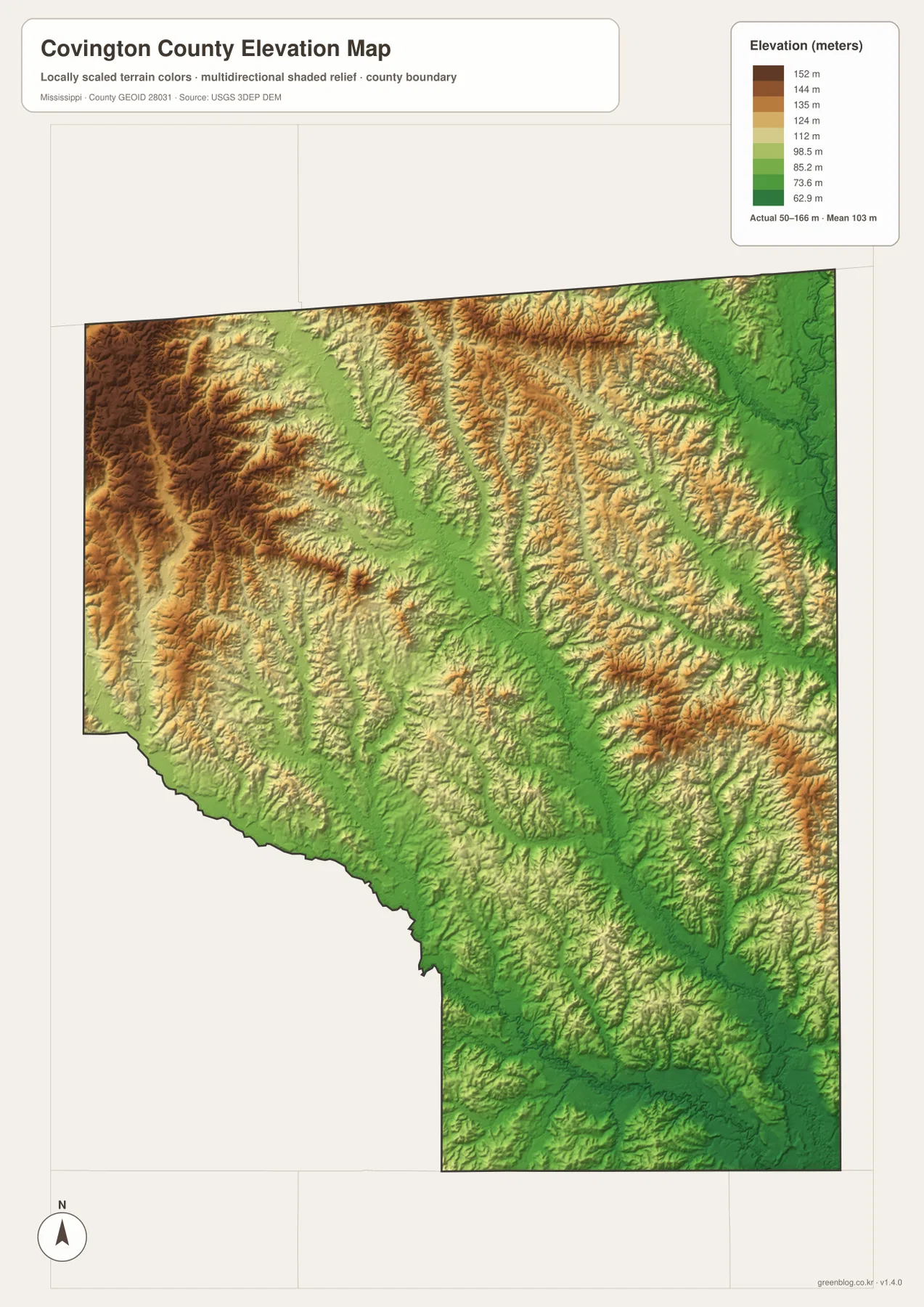
The range is modest compared with mountainous regions, yet it matters locally. The northwestern corner looks noticeably more dissected, with higher ridges separated by narrow low areas. Around Okatoma Creek and other larger waterways, lower elevations form elongated bands. The southern extension is also predominantly lower than the higher northern ridges. This helps explain why the water network branches the way it does and why a simple road map can understate the county’s physical variety.
The elevation image is generalized for county-wide reference. It is appropriate for seeing relative high and low areas, but not for engineering design, parcel-level grading, or any task that requires survey-grade elevation. For those purposes, a more detailed elevation source or field survey is needed.
Choosing the map that fits the task
Different questions are easier to answer with different views. The county map is the best starting point for locating Collins, Mount Olive, Seminary, the county boundary, and numbered roads. The city map is more useful when the main question is how the principal labeled communities relate to Collins. For named creeks and lakes, the water map carries far more detail, while the elevation map is the clearest choice for explaining the contrast between ridges and low valleys.
- Location and roads: compare Collins, Mount Olive, Seminary, US 49, US 84, and state routes.
- Water references: locate Okatoma Creek, Leaf River, Station Creek, Bowie Creek, and named lakes.
- Terrain context: show how elevations from roughly 50 to 166 meters vary across ridges and creek valleys.
- Printing and editing: use the ZIP below when the larger A3 JPG originals are preferable to the on-page WebP previews.
Frequently Asked Questions
How far are Mount Olive and Seminary from Collins on the city map?
The map gives straight-line distances of about 9 miles from Collins to Mount Olive and about 7 miles from Collins to Seminary. These are direct point-to-point measurements, not road mileage or estimated driving distance.
Does Okatoma Creek form the Covington County boundary?
No. Okatoma Creek is a prominent interior waterway, but it does not define the county boundary as a whole. The water map also labels Dry Creek, Terrible Creek, Station Creek, Oakey Woods Creek, Bowie Creek, the Leaf River, and several lakes.
Where is the higher ground in Covington County?
The elevation map shows much of the higher terrain in the northwestern and northern parts of the county. Lower ground follows creek valleys through the center and continues across much of the southern section. The displayed elevation range is about 50 to 166 meters.
Sources and Reference Data
- U.S. Census Bureau QuickFacts – Covington County
- U.S. Census Bureau Gazetteer Files
- Mississippi Encyclopedia – Covington County
- Mississippi Department of Transportation official highway map
- USGS National Hydrography
- USGS 3D Elevation Program
Map File Information
The ZIP contains high-resolution A3 JPG versions of the county, city-connection, water, and elevation maps shown on this page. Use it when you need larger originals for printing, documents, or presentations.
- Included Files: county map, city map, water map, elevation map
- File Type: ZIP containing 4 JPG files
Related Maps
Green Map creates custom-edited map images using open geographic data sources such as geoBoundaries, Natural Earth, OpenStreetMap, and government open data. These maps are edited visual materials, not raw data files, and are provided for education, documents, presentations, and graphic reference.