DeSoto County sits at the northern edge of Mississippi, directly below the Memphis area, but the county is not one continuous suburban landscape. Southaven, Horn Lake, and Olive Branch form a dense northern cluster near the Tennessee line, while Hernando lies farther south as the county seat. West of those communities, the land drops toward the Mississippi River and a much flatter river-side setting. The maps on this page show those contrasts through roads, city distribution, waterways, and elevation, and the matching high-resolution A3 JPG files are available to download in one ZIP archive.
A useful way to understand DeSoto County is to follow the county from north to south and then compare east with west. Major highways tie the Memphis-facing cities to Hernando, the eastern side rises into more strongly dissected hills, and the western side approaches the Mississippi River lowlands. Arkabutla Lake in the southwest and the Coldwater River system in the south add another layer that is easy to miss on a road-only map.
Table of Contents
From the Tennessee line to Hernando: where the main roads and cities sit
The county reference map places Southaven and Horn Lake close together near the northern boundary, with Olive Branch farther east. Hernando is clearly separated to the south and is marked with the DeSoto County Courthouse, reinforcing its role as the governmental center. Walls lies to the west, near the lower Mississippi River side of the county, while Eudora appears southwest of Hernando. That spread makes the northern urban concentration easy to distinguish from the more open western and southern areas.
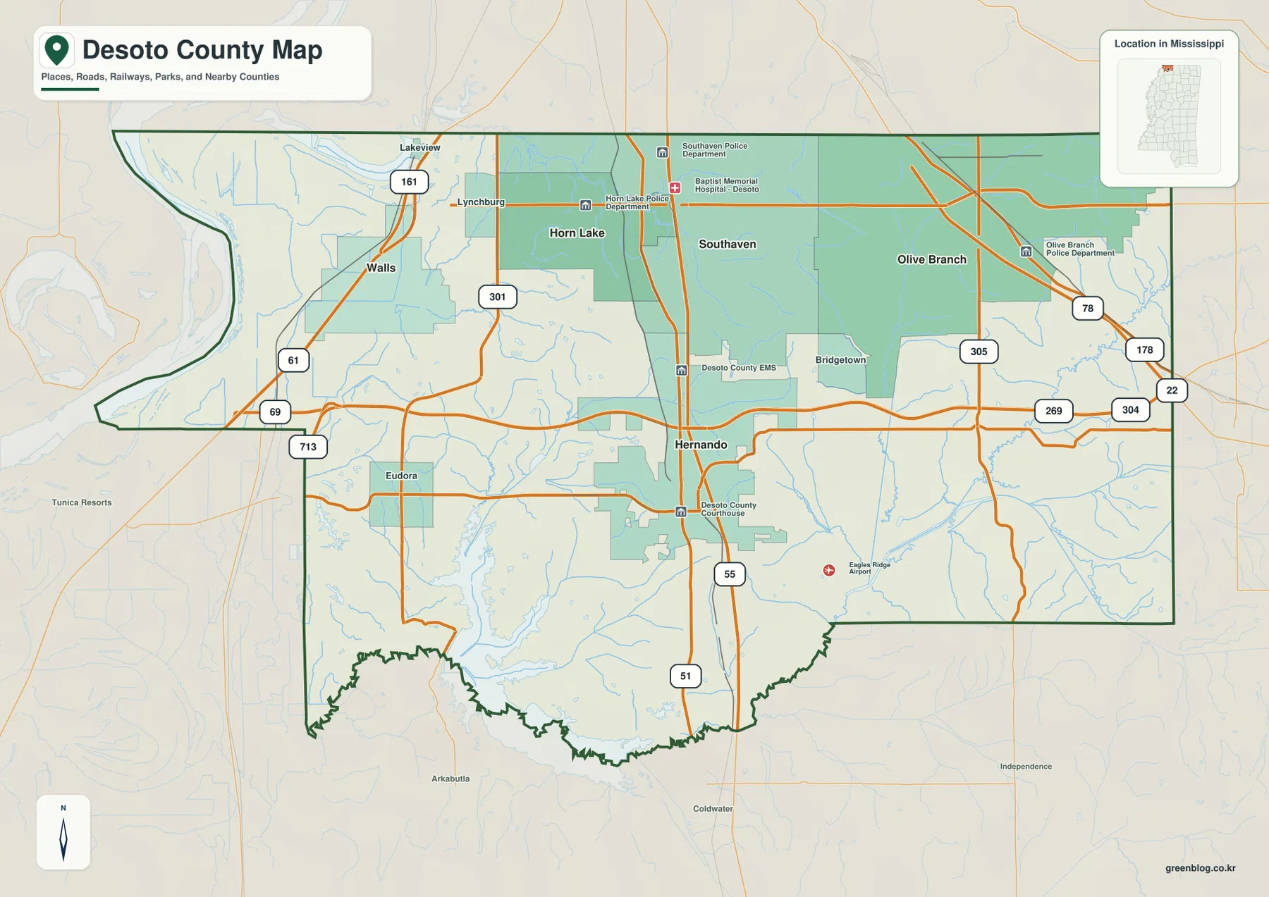
I-55 and US 51 provide a strong north–south reference through the middle of the county, linking the Memphis-facing part of DeSoto County with Hernando and points farther south. US 78 serves the Olive Branch side, while I-269 forms an important outer connection through the eastern and southern part of the county. US 61 is a useful western reference near Walls and the river side. The map also labels several state routes, including 301, 302, 305, 161, and 178, which help locate smaller communities and cross-county connections.
The county boundary itself tells part of the story. Tennessee’s Shelby County lies immediately to the north, Marshall County is to the east, and Tate County is south of DeSoto. The western side reaches the Mississippi River opposite Arkansas and bends with the river rather than following a simple straight line. Tunica County occupies the southwest side. Those neighboring areas make DeSoto a transition zone between metropolitan Memphis, inland northern Mississippi, and the Mississippi River lowlands.
A five-city ranking shows how strongly population is concentrated in the north
The city distribution map ranks five major places and makes the northern concentration unmistakable. Southaven is first and occupies the north-central part of the county. Olive Branch ranks second in the northeast, and Horn Lake ranks third just west of Southaven. Hernando, ranked fourth, is set apart to the south, while Walls, ranked fifth, sits much farther west near the river-side plain.
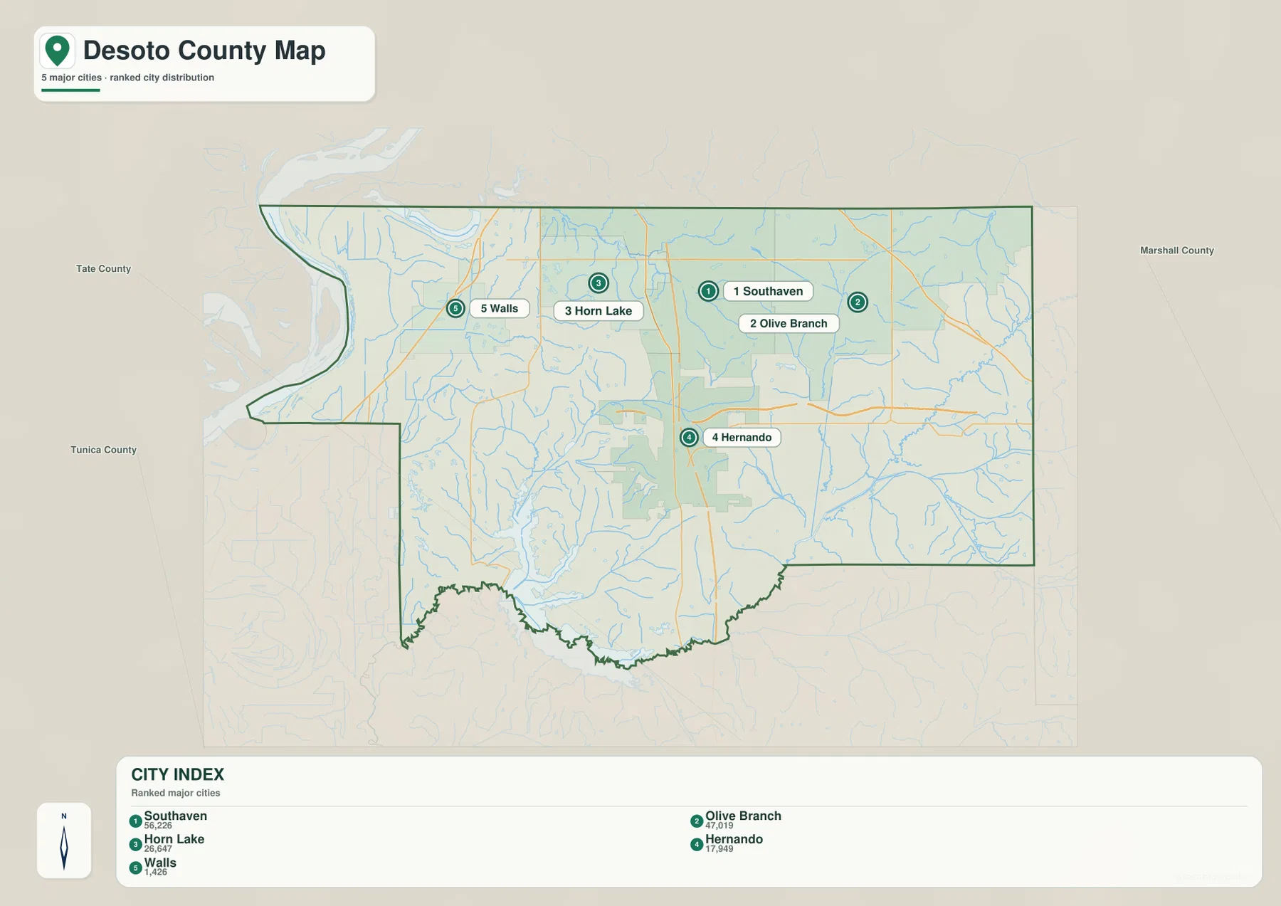
The map’s city index lists Southaven at 56,226, Olive Branch at 47,019, Horn Lake at 26,647, Hernando at 17,949, and Walls at 1,426. These figures are most useful for comparing the places shown on this map rather than as a substitute for countywide population data. For context, the 2020 census counted 185,314 residents in DeSoto County, while the July 2025 estimate shown in the source material is 197,918.
Location matters as much as rank. Southaven, Horn Lake, and Olive Branch all sit close to the Tennessee line and the Memphis metropolitan edge, so they form a compact northern group. Hernando’s position farther south separates the county seat from that cluster. Walls represents a different setting again: it lies west of the main interstate corridor and closer to the Mississippi River floodplain. The city map therefore helps explain why a single countywide population density number cannot describe every part of DeSoto equally well.
Mississippi River lowlands, Arkabutla Lake, and the Coldwater River system
The terrain and water map shifts attention away from highways and toward the drainage network. The Mississippi River dominates the western edge, with Norfolk Lake, Mud Lake, and Horn Lake nearby. Horn Lake Creek crosses the northern interior, while Hurricane Creek runs through the center. Camp Creek and Campground Canal appear farther east, and a dense pattern of smaller tributaries fills the spaces between the named waterways.
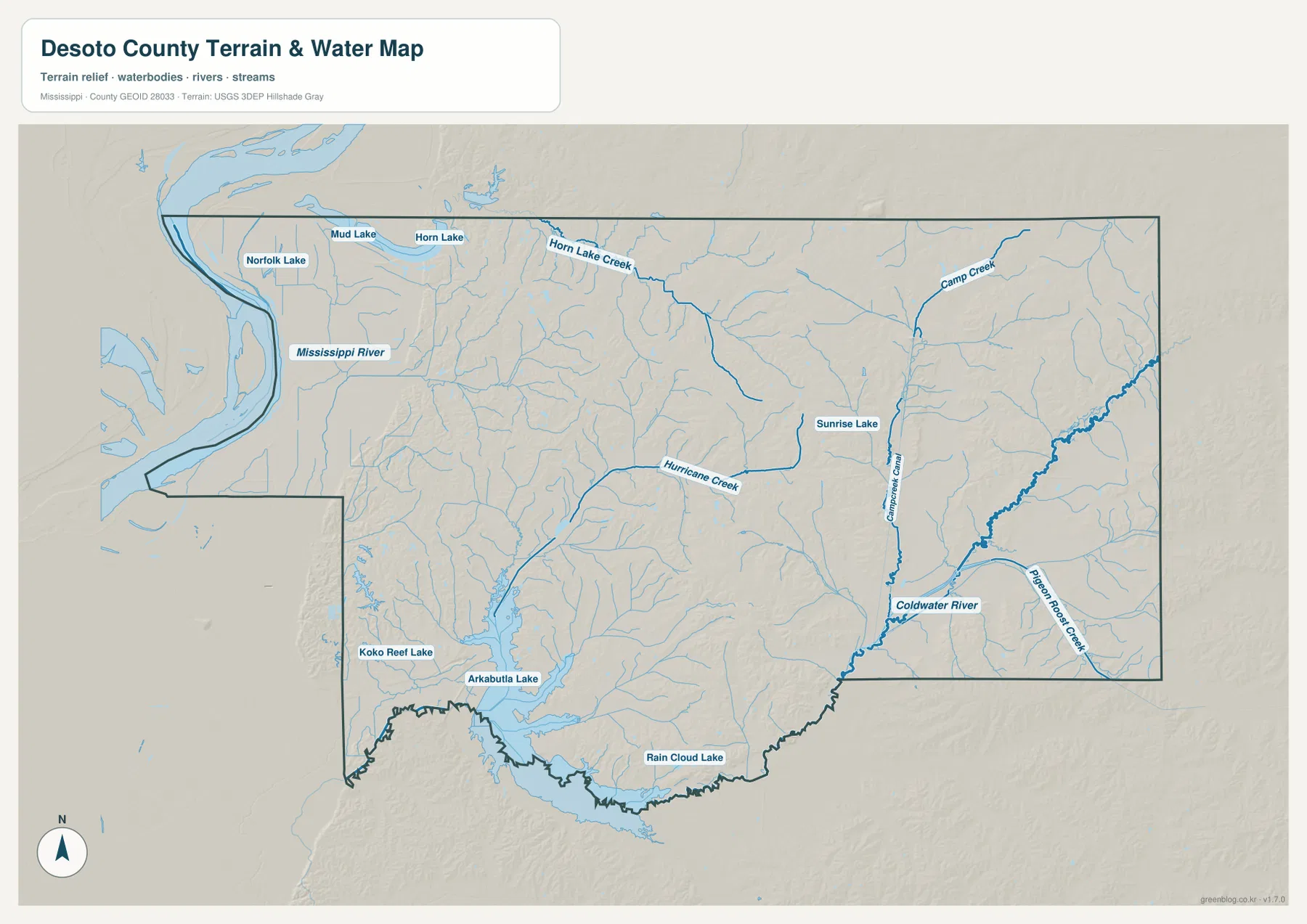
Arkabutla Lake is the largest inland water body shown and occupies a prominent position in the southwest. Koko Reef Lake lies just to its west, while Rain Cloud Lake appears near the southern boundary. In the southeast, the Coldwater River and Pigeon Roost Creek provide the main named drainage references. Sunrise Lake is shown in the central-eastern portion of the county. Together, these features show that DeSoto’s water geography extends well beyond the Mississippi River itself.
This map is designed to locate rivers, creeks, lakes, and general terrain. It should not be used as a flood-zone map, a navigation chart, a parcel boundary map, or a source for water depth. For a classroom or regional overview, it works best when the Mississippi River and Arkabutla Lake are used as major anchors and the smaller streams are added to explain how water moves through the county.
Elevation rises sharply from the western river side toward the eastern hills
The elevation map gives DeSoto County an actual range of about 48 to 133 meters, with a mean near 88 meters. The lowest colors spread across the western edge near the Mississippi River and continue through much of the southwest around Arkabutla Lake. By contrast, the northeast and eastern side contain broad areas of higher brown and tan relief, with closely spaced ridges and valleys that are absent from the river-side plain.
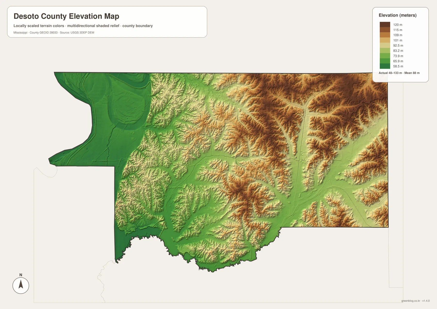
The middle of the county is more varied. Low corridors follow parts of the drainage network, while isolated higher ridges appear between them. Hernando sits near this transition rather than at either extreme. The pattern is especially useful for comparing the Southaven–Horn Lake side with the Olive Branch side: communities that look close on a road map can occupy noticeably different terrain settings.
The colored surface is a countywide elevation reference, not a survey product. It is appropriate for identifying broad high and low areas, but not for engineering design, drainage construction, or a precise parcel elevation. Those uses require detailed elevation data or field measurements.
County size and population numbers make more sense when read with the maps
The 2025 Gazetteer values in the source material list 476.394 square miles of land and 19.395 square miles of water for DeSoto County. Using the 2020 census count and the land area gives an overall density of about 389 residents per square mile. That average is useful for broad comparison, but the city map shows why it should not be treated as an even distribution. Much of the population is concentrated near Southaven, Olive Branch, and Horn Lake, while the western and southwestern portions are far less urban.
That contrast also explains why DeSoto County can feel both metropolitan and rural depending on where the map is viewed. The northern edge is tied closely to Memphis through city streets and major highways. The west is shaped by the Mississippi River lowlands, and the south contains large water and drainage features around Arkabutla Lake and the Coldwater River. Reading the statistics beside these geographic differences gives a more useful picture than the numbers alone.
Choosing the right DeSoto County map for a project
For a quick orientation to roads, communities, and county boundaries, start with the general county map. Use the city distribution map when the main question is how Southaven, Olive Branch, Horn Lake, Hernando, and Walls compare in location and relative size. The water map is the better choice for the Mississippi River, Arkabutla Lake, Coldwater River, and named creeks. Add the elevation map when the difference between western lowlands and eastern hills matters to the explanation.
- Regional orientation: compare the Memphis-facing cities with Hernando and the western side of the county
- Transportation reference: locate I-55, I-269, US 51, US 61, US 78, and state routes
- Water and terrain: show the Mississippi River, Arkabutla Lake, Coldwater River, and the county’s creek network
- Printing and editing: use the ZIP below for the original A3 high-resolution JPG versions
Frequently Asked Questions
Is Southaven the county seat of DeSoto County?
No. Southaven is the largest city shown on the city distribution map, but Hernando is the county seat. The county reference map marks the DeSoto County Courthouse in Hernando, which makes the administrative role clear.
Where is the lowest terrain in DeSoto County?
The broadest low-elevation area is on the western side near the Mississippi River, with additional low ground around Arkabutla Lake and major drainage corridors. The map’s countywide elevation range is approximately 48–133 meters.
Does the water map show flood zones around the Mississippi River or Arkabutla Lake?
No. It is a reference map for named rivers, creeks, lakes, and general terrain. Flood-risk decisions require dedicated flood-hazard data from the appropriate official source.
Map File Information
The DeSoto County reference map, city distribution map, water map, and elevation map are packaged as high-resolution A3 JPG files. Download the ZIP when you need originals larger than the on-page WebP previews.
- Included Files: county map, city map, water map, elevation map
- File Type: ZIP containing 4 JPG files
Related Maps
Sources and References
- U.S. Census Bureau QuickFacts – DeSoto County
- U.S. Census Bureau Gazetteer Files
- Mississippi Encyclopedia – DeSoto County
- Mississippi Department of Transportation official highway map
- USGS National Hydrography
- USGS 3D Elevation Program
Green Map creates custom-edited map images using open geographic data sources such as geoBoundaries, Natural Earth, OpenStreetMap, and government open data. These maps are edited visual materials, not raw data files, and are provided for education, documents, presentations, and graphic reference.