This Forrest County Map brings together the county’s north-heavy city pattern, the road network around Hattiesburg and Petal, its rivers and smaller lakes, and the change from low river corridors to rolling southern terrain. The page uses separate county, city, water, and elevation views so a reader can move from basic orientation to more detailed physical geography without mixing the purposes of the maps. A ZIP containing the high-resolution A3 JPG files is available in the map file box below.
Forrest County has a distinctive elongated shape. Most of the prominent city and highway labels are concentrated in the north, while the long southern section contains fewer settlement labels and a much denser pattern of creeks, valleys, and ridges. Reading the county this way makes Hattiesburg more than a dot near the top of the page: it becomes the point where the urban area, major roads, river system, and lower terrain meet.
Table of Contents
Hattiesburg, Petal, and the Northern Road Network
The general county map is anchored by Hattiesburg, where the Forrest County Courthouse and Sheriff’s Office are marked. Petal lies to the northeast, while Rawls Springs and Glendale provide additional reference points across the northern part of the county. I-59, US 49, and US 98 approach Hattiesburg from different directions, and US 11 and MS 42 add more connections north of the urban core. The result is not a single straight transportation corridor but a set of routes that converge around the county’s main population center.
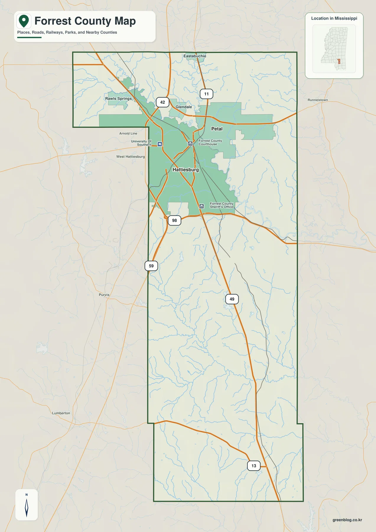
The boundary itself is useful for orientation. The northwest side steps inward before the county continues south in a long, narrow body. Lamar County lies to the west, Jones County to the northeast, Perry County to the east, Stone County to the southeast, Pearl River County to the southwest, and Covington County farther west of the lower portion. Labels such as Purvis, Lumberton, and Runnelstown sit outside the county but help show which direction neighboring places lie from Forrest County.
Two Major Cities Concentrated in the North
The city map strips away much of the road detail and makes the settlement pattern especially clear. Hattiesburg and Petal are the two major cities displayed in the county, both in the northern section. The city index printed on the map lists Hattiesburg at 48,619 and Petal at 11,294. No comparable major-city marker appears through the long southern half, which makes the contrast between the urban north and the more lightly settled south easy to see.
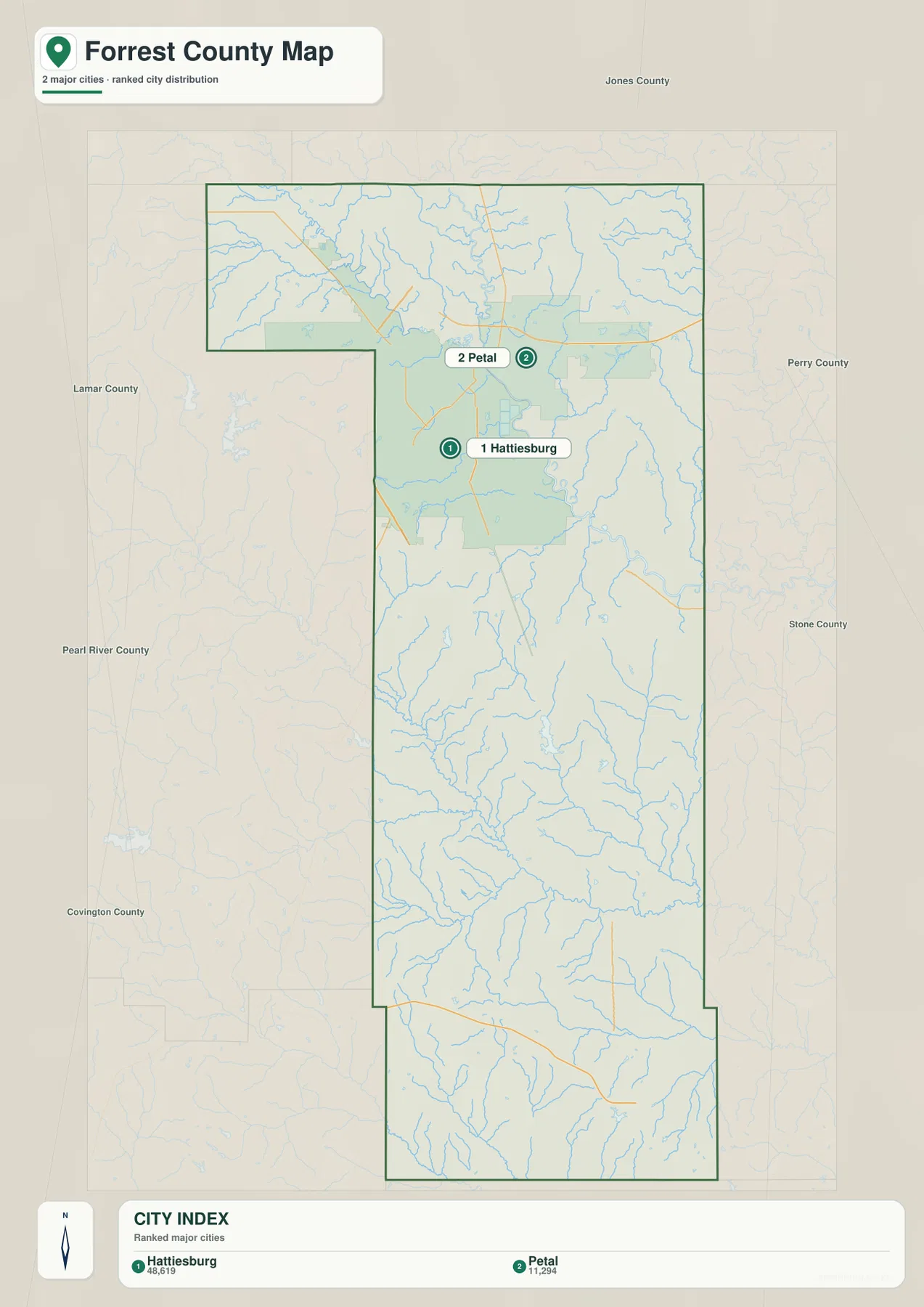
Those city figures should not be confused with the population of the entire county. The existing county data in this package gives a 2020 census population of 78,158 and a July 2025 estimate of 79,034. People outside Hattiesburg and Petal are included in the county total, so the city map is best used to compare the main urban centers rather than to account for every resident or community.
Leaf River, Bouie River, and a Web of Smaller Waterways
The water map adds a different layer of detail. Bouie River enters the northern part of the county and trends toward the Hattiesburg area, while Leaf River continues along the eastern side of the central section. Greens Creek and Roses Creek approach from the east, and Black Creek and Big Creek mark important drainage lines farther south. Double Branch is labeled near the southern end, showing that named streams continue almost to the bottom of the county.
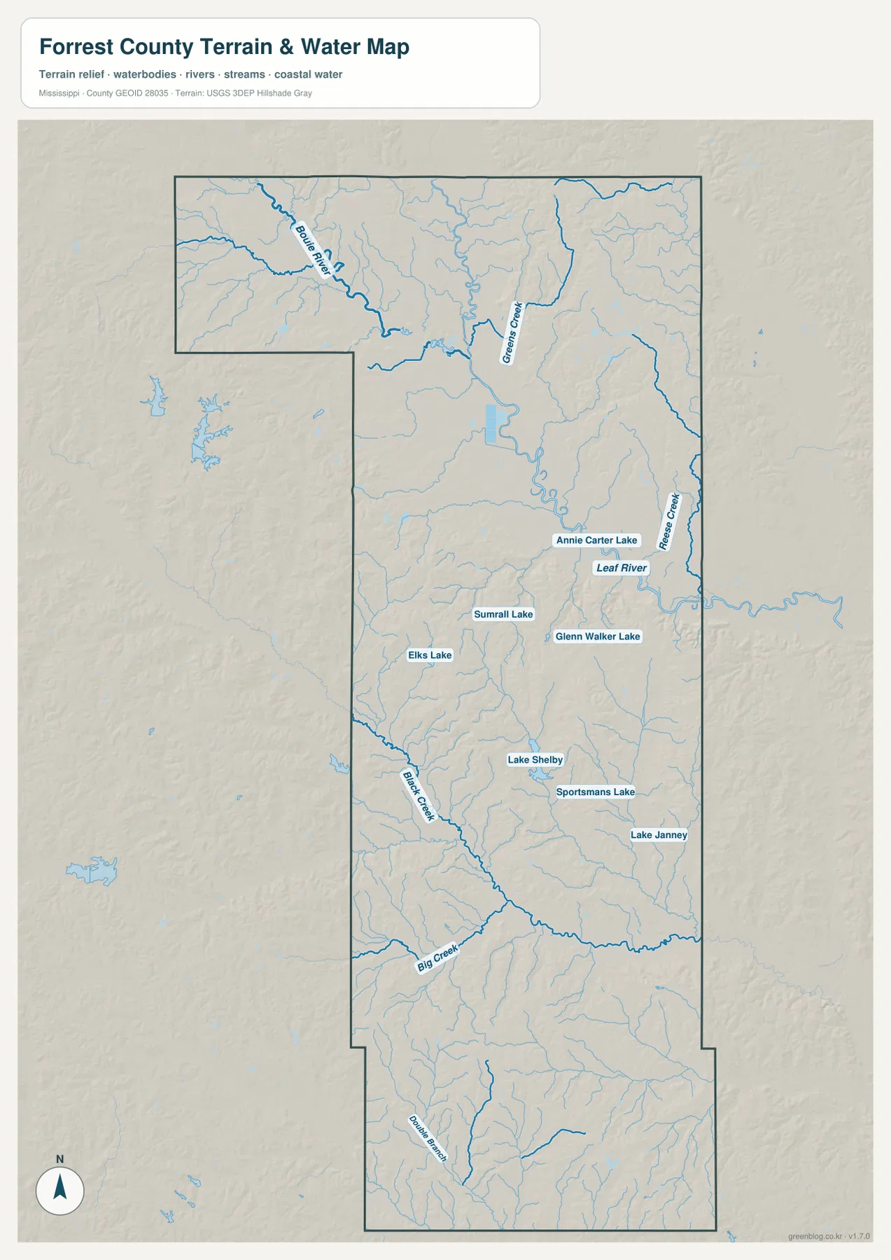
Several lakes provide smaller but useful reference points. Annie Carter Lake sits close to Leaf River; Sumrall Lake, Elks Lake, and Glenn Walker Lake are spread across the middle portion; and Lake Shelby, Sportsmans Lake, and Lake Janney appear farther south. This distribution helps explain why the county cannot be summarized by one river alone. The larger channels provide the main orientation, but the smaller lakes and tributaries fill much of the interior.
The package’s 2025 Gazetteer values list 466.042 square miles of land and 4.198 square miles of water. Water therefore occupies only a small share of the county’s total area, yet the water map shows that streams cross a much broader portion of the landscape than a simple water-area percentage might suggest. For map reading, the location and direction of the channels matter more than the size of the blue polygons alone.
A 30–125 Meter Elevation Range Across Valleys and Ridges
The elevation map shows actual terrain from about 30 to 125 meters, with a mean elevation of 69 meters. The northern center and major river corridors are generally lower, while higher ground appears along parts of the northeast edge and across much of the central-southern and southern county. In the lower half, narrow valleys cut between repeated ridges, producing a much more textured surface than the road map suggests.
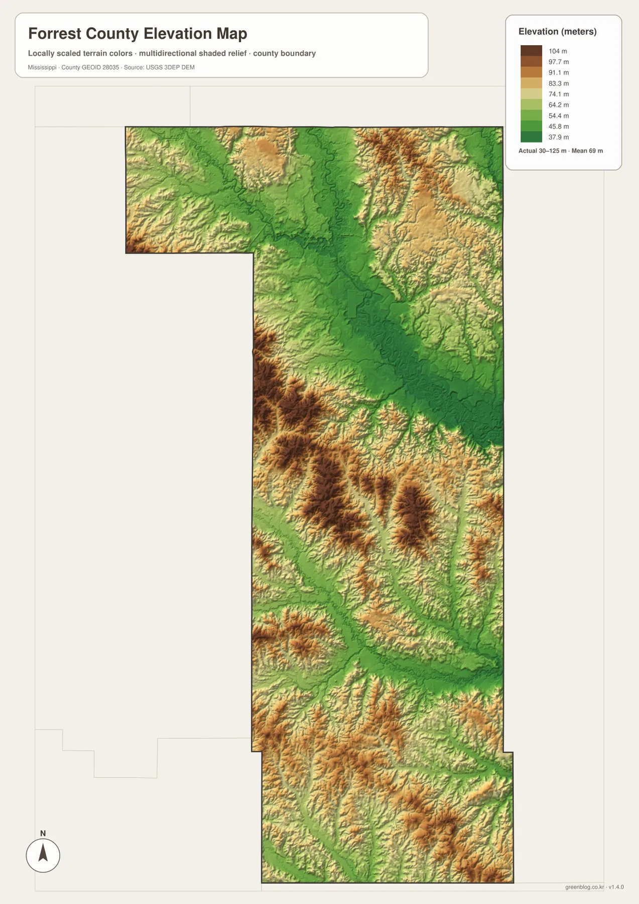
Comparing the elevation and water maps is especially helpful. Lower green areas follow many of the larger river and creek corridors, while browner ridges rise around them. That relationship is visible south of the Hattiesburg area as the county becomes more dissected by tributaries. A reader looking only for a highway may prefer the general map, but anyone trying to understand the shape of the land around the streams will get more information from the elevation view.
County Reference Facts and How to Use the Maps
- State and county: Mississippi, Forrest County
- FIPS code: 28035
- County seat: Hattiesburg
- 2020 census population: 78,158
- July 2025 population estimate: 79,034
- 2025 Gazetteer area: 466.042 sq mi land and 4.198 sq mi water
- Elevation shown on this map: about 30–125 m; mean 69 m
These values come from different kinds of references and should be read accordingly. The census count and population estimate have different dates, the land and water figures are Gazetteer measurements, and the elevation range is the value printed on the supplied elevation map. For a current route, boundary, hydrography, or elevation dataset, the official links in the source section provide the appropriate place to continue checking details.
For quick orientation, start with the county map and locate Hattiesburg, Petal, and the main highways. Use the city map when the north-heavy settlement pattern is the main question. The water map is better for following Leaf River, Bouie River, creeks, and lakes, while the elevation map shows where valleys and higher rolling ground replace the flatter appearance of a standard road map. The downloadable JPG set keeps all of these views available at a larger A3 size for printing, editing, or close inspection.
Frequently Asked Questions
How are Hattiesburg and Petal positioned on the Forrest County maps?
Both are in the northern part of the county. Hattiesburg is the larger labeled center and is surrounded by several major road connections, while Petal appears a short distance to the northeast as a separate city.
Which waterways are most useful for orienting the water map?
Bouie River and Leaf River are the main large-channel references in the northern and central parts of the county. Greens Creek, Black Creek, Big Creek, and other tributaries add detail, and several named lakes help locate smaller water bodies across the interior.
Where does the Forrest County elevation map show higher terrain?
Higher ground is more common in parts of the northeast and across the central-southern and southern county, while the river corridors and northern center are generally lower. The map shows an actual elevation range of roughly 30–125 meters with a mean of 69 meters.
Sources and Reference Data
- U.S. Census Bureau QuickFacts – Forrest County
- U.S. Census Bureau Gazetteer Files
- Mississippi Department of Transportation official highway map
- USGS National Hydrography
- USGS 3D Elevation Program
- Mississippi Encyclopedia – Forrest County
Map File Information
The ZIP contains the Forrest County county, city, water, and elevation maps as high-resolution A3 JPG files for printing or reuse.
- File Type: JPG
Related Maps
Green Map creates custom-edited map images using open geographic data sources such as geoBoundaries, Natural Earth, OpenStreetMap, and government open data. These maps are edited visual materials, not raw data files, and are provided for education, documents, presentations, and graphic reference.