Franklin County in southwest Mississippi is easiest to understand by following the US 84 line through Bude, Meadville, and Roxie, then looking beyond the highway to the dense network of streams and wooded hills that fills much of the county. This page brings the county boundary, roads, settlement locations, water features, and elevation together in one guide. High-resolution JPG versions of the supplied maps are also available as a ZIP download for printing, editing, classroom use, or presentations.
The maps do not show a county dominated by one large urban center. Instead, a few small communities occupy relatively narrow road corridors while broad areas between them contain creeks, river valleys, and rolling terrain. Comparing the road map with the water and elevation maps makes those open spaces much more meaningful than they appear on a simple place-name map.
Table of Contents
Bude, Meadville, and Roxie along US 84
The county overview makes US 84 the clearest east-west reference across Franklin County. Roxie lies on the western side of the county, Meadville is near the middle, and Bude sits just to the east of the county seat. MS 33 crosses near Roxie, while other state routes branch south and east from the central corridor. Route labels 84E, 98, 567, and 570 appear near the eastern and southern edges, helping orient the reader toward neighboring parts of southwest Mississippi.
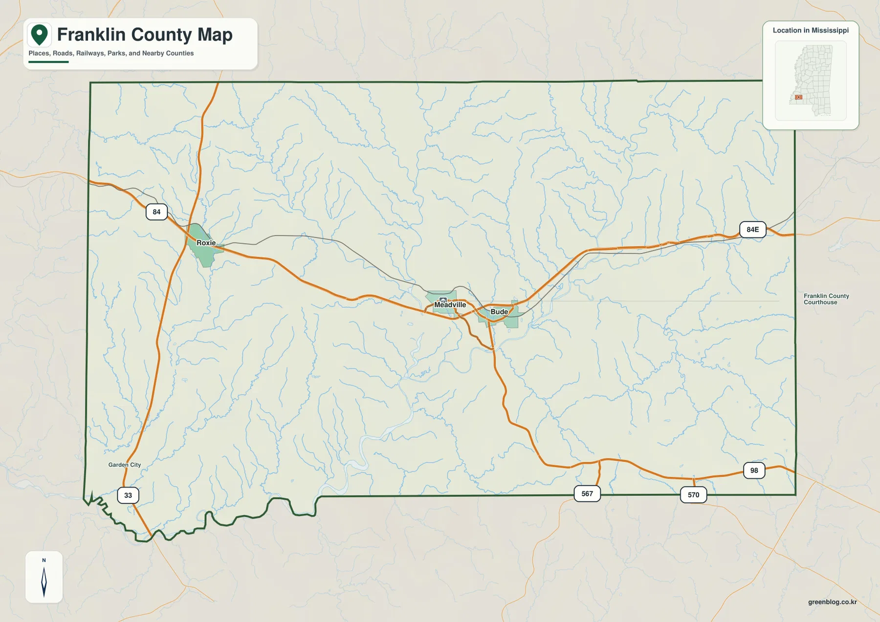
Meadville is the county seat, but Bude is so close that the two labels nearly form one central cluster on the map. Roxie is much farther west and works as a useful reference for the county’s western side. The general map also shows how few major-road lines reach the broad northern and southeastern interior, where smaller roads and natural features become more important than town labels.
For a quick orientation, the county map is the best place to start because it combines place names, the boundary, and the main road network without adding too much detail. It is especially useful for explaining how US 84 ties together the three most visible communities and how MS 33 provides a north-south connection on the western side.
City spacing from the Bude hub
The city-connections map uses Bude as its hub and gives direct-distance comparisons to two other labeled communities. Meadville is shown about 2 miles from Bude, while Roxie is about 13 miles away. Those are straight-line reference distances rather than driving mileage, so they are most useful for comparing position and spacing rather than planning a road trip.
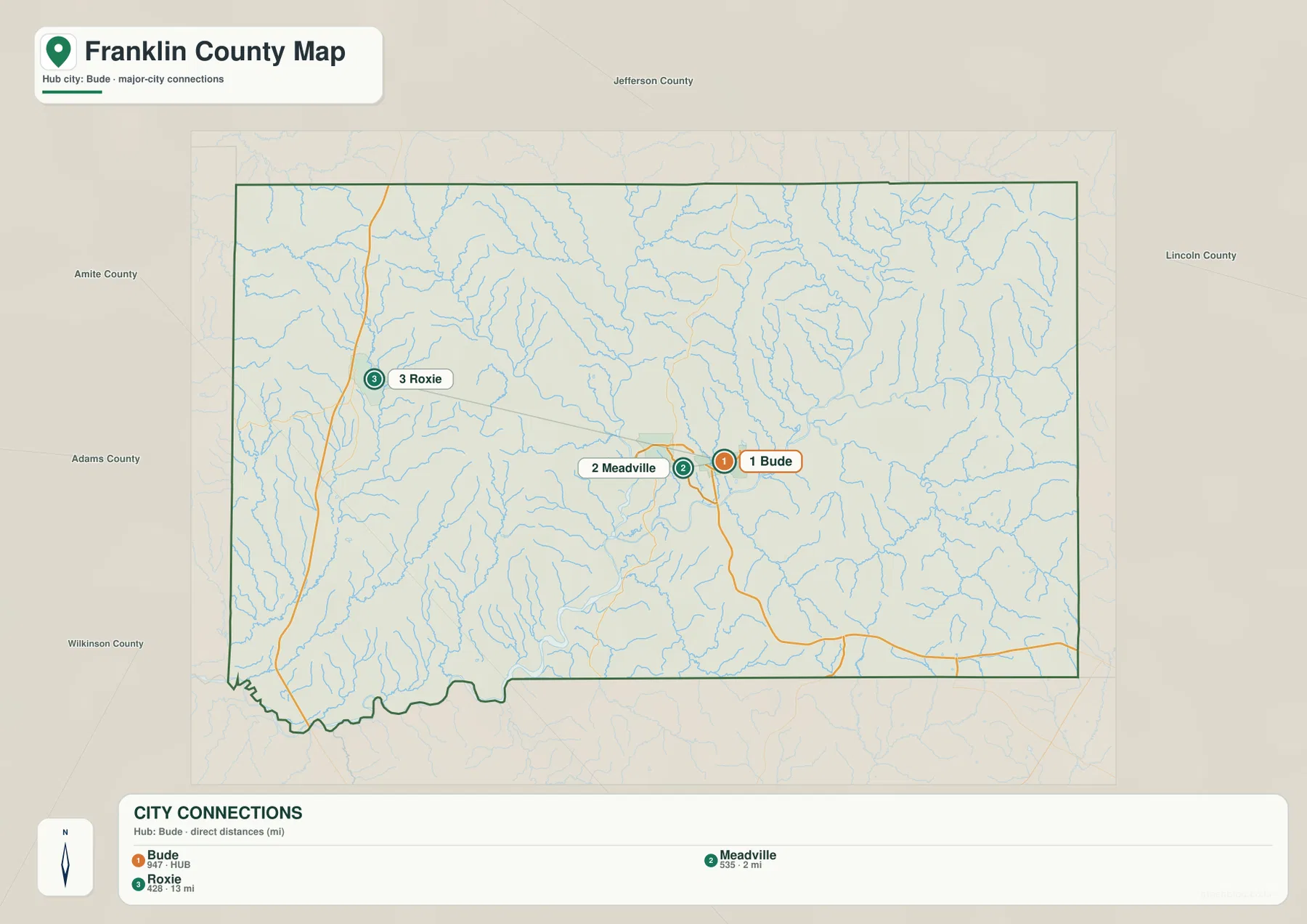
Neighboring county names around the map add another layer of orientation. Jefferson County is to the north, Lincoln County to the east, Amite and Adams counties are on the western side, and Wilkinson County appears toward the southwest. This makes it easy to see that Bude and Meadville occupy a fairly central position within Franklin County while Roxie sits closer to the western approaches.
A map with only three highlighted communities can be more useful than a crowded town list when the goal is to explain county structure. Bude and Meadville establish the central reference, and Roxie shows how far the settled US 84 corridor extends toward the west. For a school report or a short regional overview, those three labels are enough to describe the main settlement pattern before adding river or elevation detail.
Homochitto River drainage and the creek network
The terrain-and-water map changes the character of the county immediately. Middle Fork Homochitto River runs prominently through the central part of Franklin County and connects toward the Homochitto River in the southwest. Numerous tributaries occupy the ridges and valleys around it, including Wells Creek and Cole Creek in the west, Dry Creek and Richardson Creek farther south, Middleton Creek near the lower center, and Porter, Horse, and McGehee creeks on the eastern side.
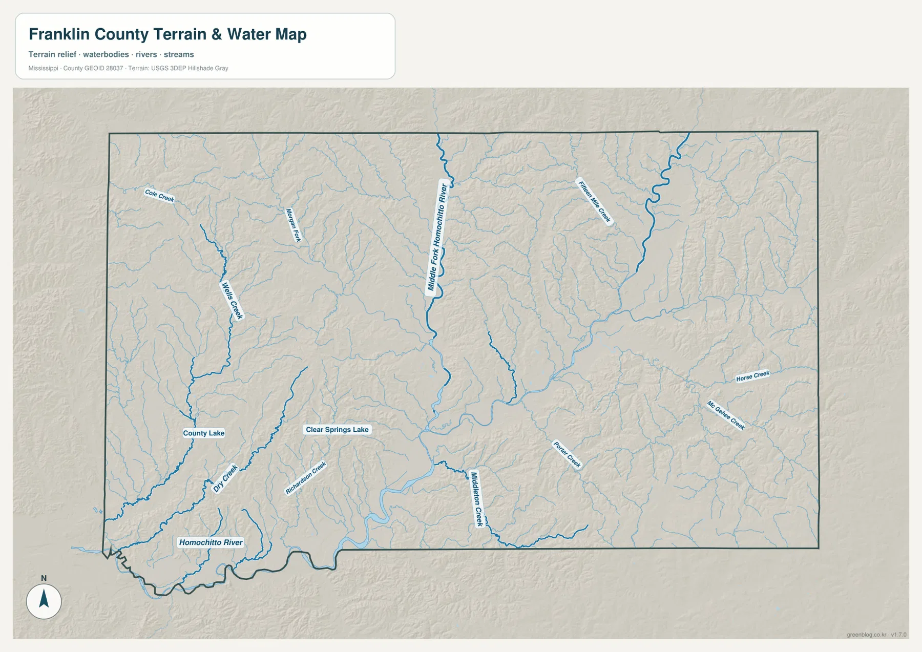
County Lake and Clear Springs Lake are the most prominent labeled lakes on this supplied water map. They are small compared with the river system, but they provide useful fixed points in an otherwise intricate pattern of narrow tributaries. The number of blue lines helps explain why large spaces between town labels are not empty land: they contain many short valleys and drainage channels.
The central river corridor is broader and more continuous than most of the side creeks. Along the southwest edge, the Homochitto River and county boundary both become more irregular, while the eastern half contains many short tributaries descending from higher ground. Looking at the water map beside the road map helps explain why routes do not simply cross the county in a uniform grid. Roads must connect communities through a landscape cut by streams and uneven terrain.
A 27–155 m elevation range across rolling terrain
The elevation map shows an actual range of roughly 27 to 155 meters, with an average near 97 meters. Green shades mark lower ground, while tan and brown areas represent higher hills. The pattern is not random: lower zones generally follow the major river valleys, and higher ground becomes more extensive toward the east and in several northern ridges.
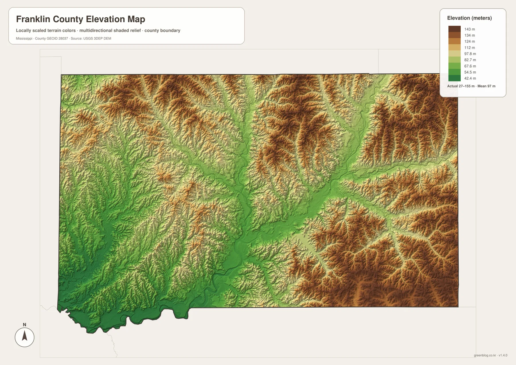
A long low corridor follows Middle Fork Homochitto River through the central part of the county. Shorter valleys branch from it, separating closely spaced ridges. The eastern side contains larger brown areas and more strongly defined ridge texture, while the southwest near the Homochitto River is generally lower. This contrast is why describing Franklin County simply as a rural forest county misses an important part of the landscape: the hills and valleys shape the county just as clearly as its towns and roads do.
This map is designed for county-scale comparison, not for determining the exact elevation of a house, parcel, or road grade. It works well for showing where the broad lowlands and higher ridges are located, especially when paired with the water map. The relationship between lower green corridors and major streams is one of the clearest features in the set.
County facts that help explain the map
- County seat: Meadville
- Primary labeled communities: Bude, Meadville, Roxie
- 2020 census population: 7,675
- July 2025 population estimate: 7,491
- 2025 Gazetteer area: 563.964 sq mi land and 2.8 sq mi water
- 2020 land-area density: about 13.6 residents per sq mi
- Major road references: US 84, US 98, MS 33, 567, and 570
- Elevation shown: about 27–155 m, mean 97 m
The population and area figures provide useful context for the amount of open space visible on the maps. Using the 2020 population and land area gives a countywide density of about 13.6 residents per square mile. That low overall density matches the visual pattern of a few small communities separated by broad rural areas, although it should not be treated as an even distribution from one part of the county to another.
The 2025 population estimate and the 2020 census count represent different reference dates, so they should not be presented as if they were collected at the same time. Likewise, the Gazetteer separates land from water area. Although the measured water area is small compared with land, the stream network still has a major influence on the shape of valleys, local access, and the appearance of the terrain map.
Which Franklin County map should you use?
Use the county map when the question is mainly about roads, places, and the boundary. Choose the city-connections map when you want to explain how close Bude and Meadville are or how much farther west Roxie lies. The water map is better for the Homochitto drainage, named creeks, and lakes, while the elevation map is the clearest choice for comparing the lower river corridors with the higher eastern ridges.
For a presentation, a useful sequence is to begin with the US 84 road map and then add either the water or elevation map. That makes the geography easier to follow: first locate Bude, Meadville, and Roxie, then show the Middle Fork Homochitto River valley and the surrounding hills. The high-resolution JPG files in the download below are better suited to printing, cropping, or adding labels than the smaller WebP previews used on the page.
Frequently Asked Questions
How close are Bude and Meadville on the map?
The city-connections map places Meadville about 2 miles from the Bude hub by straight-line distance. Driving distance can be different, but the map correctly shows that the two communities form a very close central pair within Franklin County.
What water feature stands out most in Franklin County?
Middle Fork Homochitto River is the most prominent central river on the supplied water map, and it connects toward the Homochitto River in the southwest. Many named creeks branch through the surrounding hills, producing a dense drainage pattern across the county.
Is Franklin County flat or hilly?
It is not flat. The elevation map spans roughly 27 to 155 meters, with lower river valleys through the center and southwest and higher, more strongly ridged terrain toward the east and parts of the north.
Map File Information
The download contains the Franklin County overview, city-connections, terrain-and-water, and elevation maps as high-resolution A3-proportioned JPG files. Use the ZIP when you need larger originals for printing, editing, lessons, reports, or presentation graphics.
- Included Files: county map, city map, water map, elevation map
Related Maps
Sources and References
- U.S. Census Bureau QuickFacts – Franklin County, Mississippi
- U.S. Census Bureau Gazetteer Files
- Mississippi Department of Transportation official highway map
- USGS National Hydrography
- USGS 3D Elevation Program
- Mississippi Encyclopedia – Franklin County
Green Map creates custom-edited map images using open geographic data sources such as geoBoundaries, Natural Earth, OpenStreetMap, and government open data. These maps are edited visual materials, not raw data files, and are provided for education, documents, presentations, and graphic reference.