Rooks County lies in northwestern Kansas, where Stockton and Plainville form two important centers across a broad rural landscape. US 24 serves the Stockton corridor, while US 183 provides a major north–south reference near Plainville. Between and around the towns, the South Fork Solomon River and a dense network of creeks cut through higher ground, giving the county much more relief than a flat road map suggests. High-resolution map files are available for download in the section below.
This guide follows Stockton, Plainville, Palco, Damar, Woodston, and Zurich across the road, water, and elevation views. Terrain ranges from about 504 to 706 meters. WebP previews are available for quick viewing, and the matching high-resolution JPG files can be downloaded together in one ZIP for printing, classroom work, or offline reference.
Table of Contents
Stockton and Plainville provide two practical centers for navigating the county
Stockton sits in the north-central part of Rooks County near US 24 and is the county seat according to the Kansas Historical Society. Plainville lies farther south near US 183 and a denser grid of local roads. Using both towns as reference points makes it easier to understand the county than treating one place as the only center.
Palco and Damar occupy the western side, Zurich lies west of Plainville, and Woodston sits east of Stockton. The towns are separated by long rural road segments, so even small communities provide useful landmarks when locating farms, stream crossings, and routes across the county.
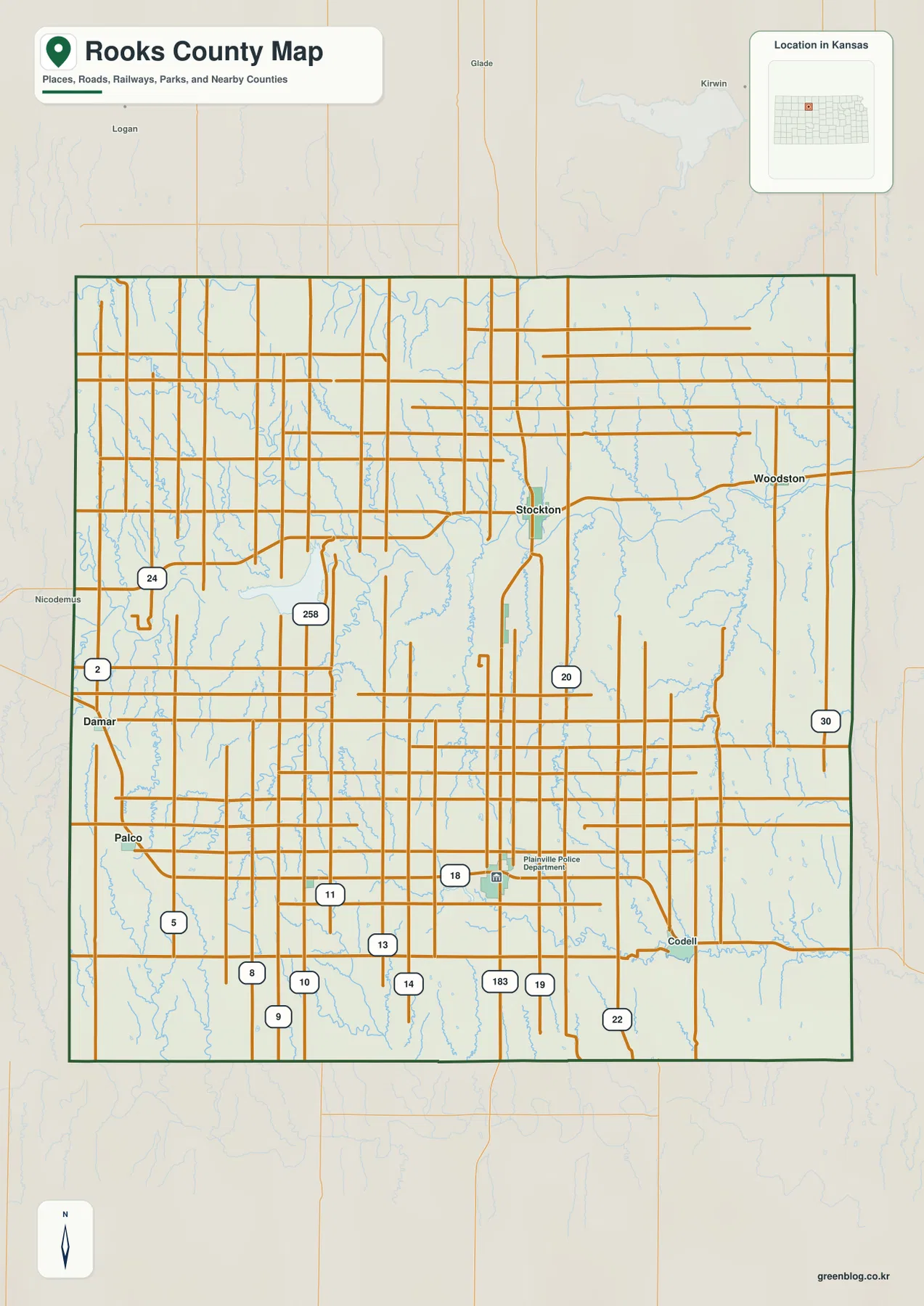
A major recreation and water landmark lies west of Stockton. Kansas Department of Wildlife and Parks places Webster State Park about eight miles west of Stockton on Highway 24, beside Webster Reservoir. That official location provides a useful real-world reference for the western US 24 corridor.
Stockton and Plainville share the top city index value
The ranked city panel lists Stockton and Plainville at the same index value of 1,656. Palco follows at 197, Damar at 126, Woodston at 86, and Zurich at 50. These are map index values rather than current official population estimates, so they should not be presented as census counts.
The identical top index does not mean the two towns occupy the same geographic role. Stockton is tied closely to the South Fork Solomon River and US 24, while Plainville anchors the southern road network near US 183 and several smaller streams. Their different settings become clearer when the city and water maps are compared.
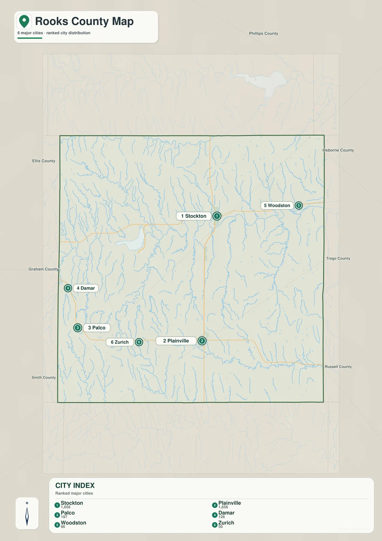
Palco and Damar form useful western references, while Zurich belongs to the Plainville side of the county. Woodston lies east of Stockton in the more heavily drained eastern terrain. The settlement pattern is therefore spread across several rural corridors rather than concentrated in one continuous strip.
The South Fork Solomon River forms the county’s broad central valley
The strongest water feature on the terrain map is the South Fork Solomon River. It enters from the west, bends across the center of the county, passes south of Stockton, and continues toward the east. Its broad valley creates the most continuous low corridor in Rooks County.
Sand Creek descends from the northwest toward the main river system, while Ash Creek crosses the northern interior. Lost Creek forms a long valley from the southwest, and smaller channels such as Bowlder Creek and Rattlesnake Creek drain the central-southern hills toward the Solomon corridor.
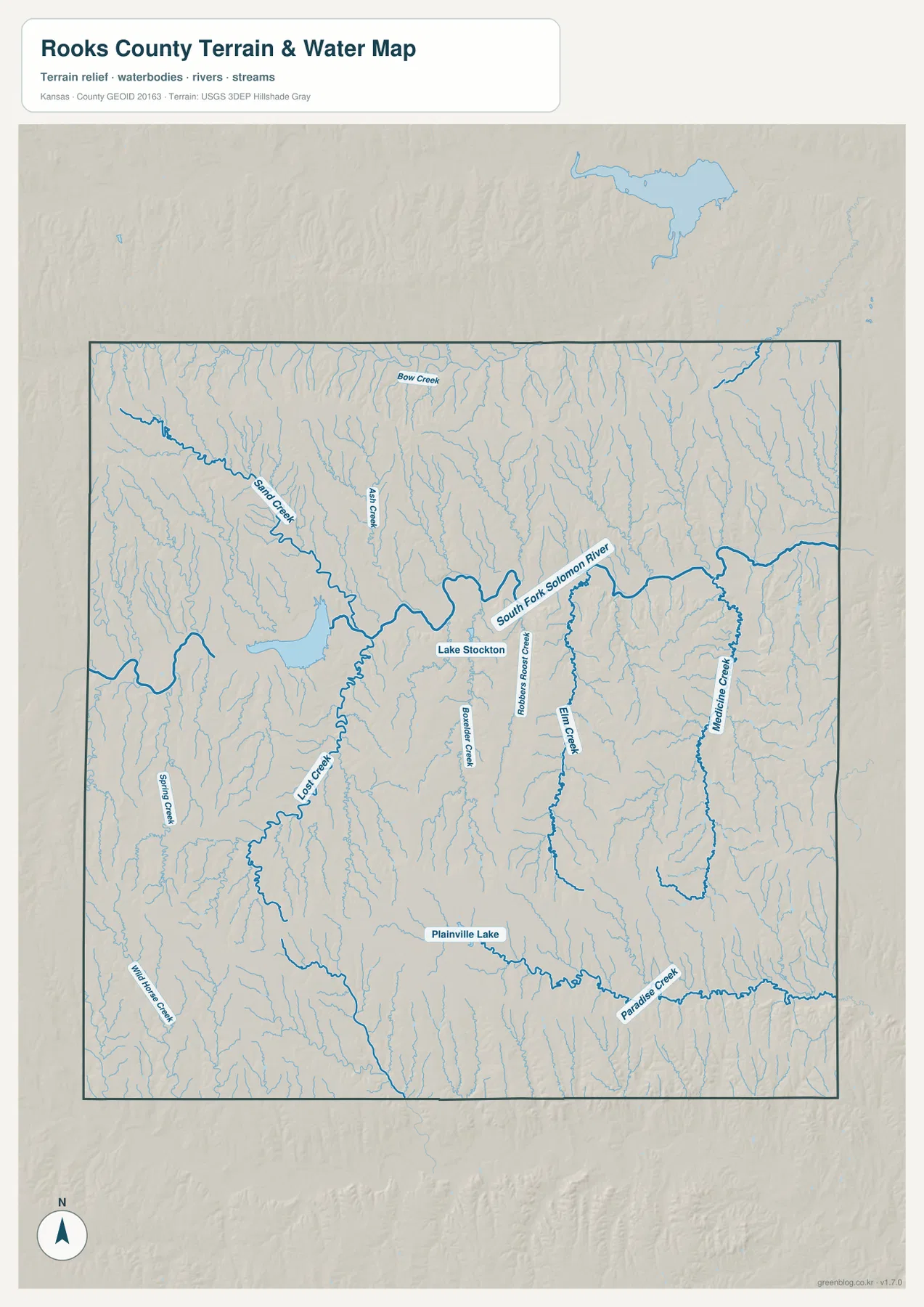
Farther east, Elm Creek and Medicine Creek form long valleys that feed the lower terrain, while Paradise Creek crosses the southeastern side. Plainville Lake is marked in the south, providing a smaller local water reference near Plainville.
The major official reservoir west of Stockton is Webster Reservoir. Kansas Department of Wildlife and Parks manages Webster State Park and Webster Wildlife Area around the reservoir and the Solomon River corridor. The park is roughly eight miles west of Stockton on Highway 24, making it closely tied to the same western landscape shown on the county map.
This water image is intended for geographic reference rather than floodplain, navigation, water-quality, parcel, or legal-access decisions. Water levels and stream conditions can change, so current agency information should be used whenever access or safety matters.
Elevation from 504 to 706 meters separates western uplands from the Solomon valley
The elevation surface ranges from about 504 to 706 meters, with a mean near 613 meters. Brown and tan high ground dominates much of the west and southwest, while the South Fork Solomon River creates a long green low corridor through the middle. Nearly 200 meters of relief separates the highest and lowest parts of the county.
The northwest contains elevated terrain cut by Sand Creek and many shorter tributaries. Around Stockton, elevation drops toward the South Fork Solomon valley, and lower ground becomes broader toward the east. South of the main river, Lost Creek and several smaller streams carve narrow valleys into higher uplands.
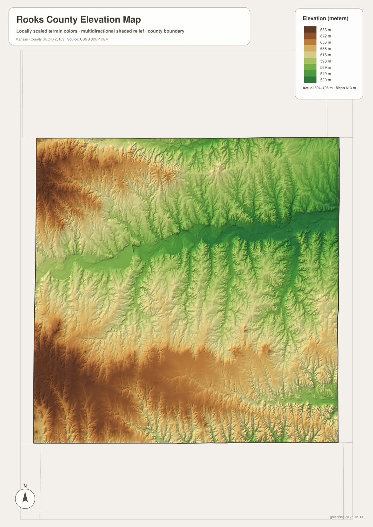
Plainville lies south of the main river in terrain that is lower than the western edge but still broken by ridges between creek valleys. Paradise Creek creates another lower corridor in the southeast, while numerous tributaries cut through the northeastern uplands.
The Kansas Historical Society places Rooks County in the transition between the Smoky Hills and High Plains. That regional description fits the supplied relief map, where higher western terrain gives way to a broad river valley and more dissected eastern country. The elevation surface remains generalized and is not suitable for survey or engineering work.
Webster State Park is a major recreation landmark west of Stockton
Webster State Park is one of the county’s most distinctive outdoor destinations. Kansas Department of Wildlife and Parks describes an 880-acre prairie park beside Webster Reservoir, about eight miles west of Stockton on Highway 24. The setting combines rolling hills, reservoir shoreline, camping, fishing, boating, and wildlife viewing.
The adjacent Webster Wildlife Area extends around the reservoir and along the Solomon River corridor. Its official page describes a large public wildlife area with reservoir access and river habitat, giving the western side of Rooks County a strong water-and-prairie identity beyond the towns shown on the road map.
The Stockton-to-Plainville route crosses from a broad river lowland into creek-cut uplands
Stockton is closely tied to the South Fork Solomon River valley, while Plainville lies farther south beyond the broad central lowland. Moving between the two means crossing upland ground dissected by Bowlder Creek, Rattlesnake Creek, Elm Creek, and other smaller drainage lines.
Plainville’s road network is centered near US 183, and Plainville Lake appears nearby on the water map. Comparing the two towns shows why county geography cannot be reduced to city size alone: Stockton is shaped by the main river corridor, while Plainville sits among smaller valleys and southern uplands.
Palco and Damar reveal the higher western side of Rooks County
Palco and Damar lie in the western half where the elevation map shows extensive tan and brown uplands. Narrow creek valleys descend from this higher ground toward the South Fork Solomon system, creating sharper local relief than the wide valley near Stockton.
Zurich provides another small reference west of Plainville. Following these western communities alongside the terrain and water maps makes the county’s west-to-east change clear: higher, more open uplands gradually give way to broader low drainage corridors.
For posters, classroom prints, or presentation slides, use the original JPG files in the download archive rather than enlarging the web previews. Small road labels, creek names, town text, and the elevation legend remain clearer at the higher resolution.
Frequently Asked Questions
Which city is largest on the supplied city index?
Stockton and Plainville share the top value at 1,656. Palco is 197, Damar 126, Woodston 86, and Zurich 50. These are map index values rather than current official population estimates.
Where does the South Fork Solomon River run through Rooks County?
It enters from the western side and crosses the middle of the county, passing south of Stockton before continuing east. Sand Creek, Ash Creek, Lost Creek, Elm Creek, and many smaller tributaries connect with the broader drainage system.
Can the 504–706 meter elevation image be used for surveying?
No. It is a generalized county-scale terrain image for comparing higher western uplands with lower river and creek valleys. Parcel elevations, engineering grades, drainage design, and legal boundary work require more precise official data and, where needed, professional surveying.
Map File Information
The archive contains the Rooks County, Kansas general county map, city map, terrain-and-water map, and elevation map as original high-resolution JPG files.
- Included Files: Use only the versions confirmed in the article and supplied images
- File Type: Use the confirmed download contents
- Intended Use: Printing, education, presentations, and map-based projects
Related Maps
Sources and references
- Kansas Historical Society: Rooks County, Kansas — county seat, Smoky Hills–High Plains setting, and local history
- Kansas Department of Wildlife and Parks: Webster State Park — Webster Reservoir, park setting, and location west of Stockton
- Kansas Department of Wildlife and Parks: Webster Wildlife Area — reservoir and Solomon River wildlife-area information
- U.S. Census Bureau TIGER/Line Shapefiles — county boundary and geographic reference data
- USGS National Hydrography — river and stream reference data
- USGS 3D Elevation Program — elevation and terrain reference data
Green Map creates custom-edited map images using open geographic data sources such as geoBoundaries, Natural Earth, OpenStreetMap, and government open data. These maps are edited visual materials, not raw data files, and are provided for education, documents, presentations, and graphic reference.