George County sits in southeastern Mississippi, where Lucedale forms the clearest road and settlement center while broad river lowlands occupy much of the western side. This page brings together the county boundary and road map, a city distribution map, a waterways map, and an elevation map so you can compare where people and roads are concentrated with the terrain underneath them. A ZIP containing the matching high-resolution A3 JPG map files is available for download near the end of the article.
The county is more varied than its modest elevation numbers might suggest. US 98 and several state highways converge around Lucedale in the northeast, but the western half is dominated by the Pascagoula River system and a broad low valley. Farther east, toward the Alabama line and the Escatawpa River, the land becomes more dissected and hilly. Looking across all of the supplied maps makes those contrasts much easier to understand than reading a list of place names alone.
Table of Contents
Lucedale as the Road Hub Near the Alabama Side
The general county map makes Lucedale the most obvious reference point. US 98 runs east–west through the area, while MS 26 and MS 63 meet near the city and MS 198 continues eastward. Other roads extend north and south from the same area, so Lucedale works as both the county seat and the easiest place from which to explain travel directions across George County.
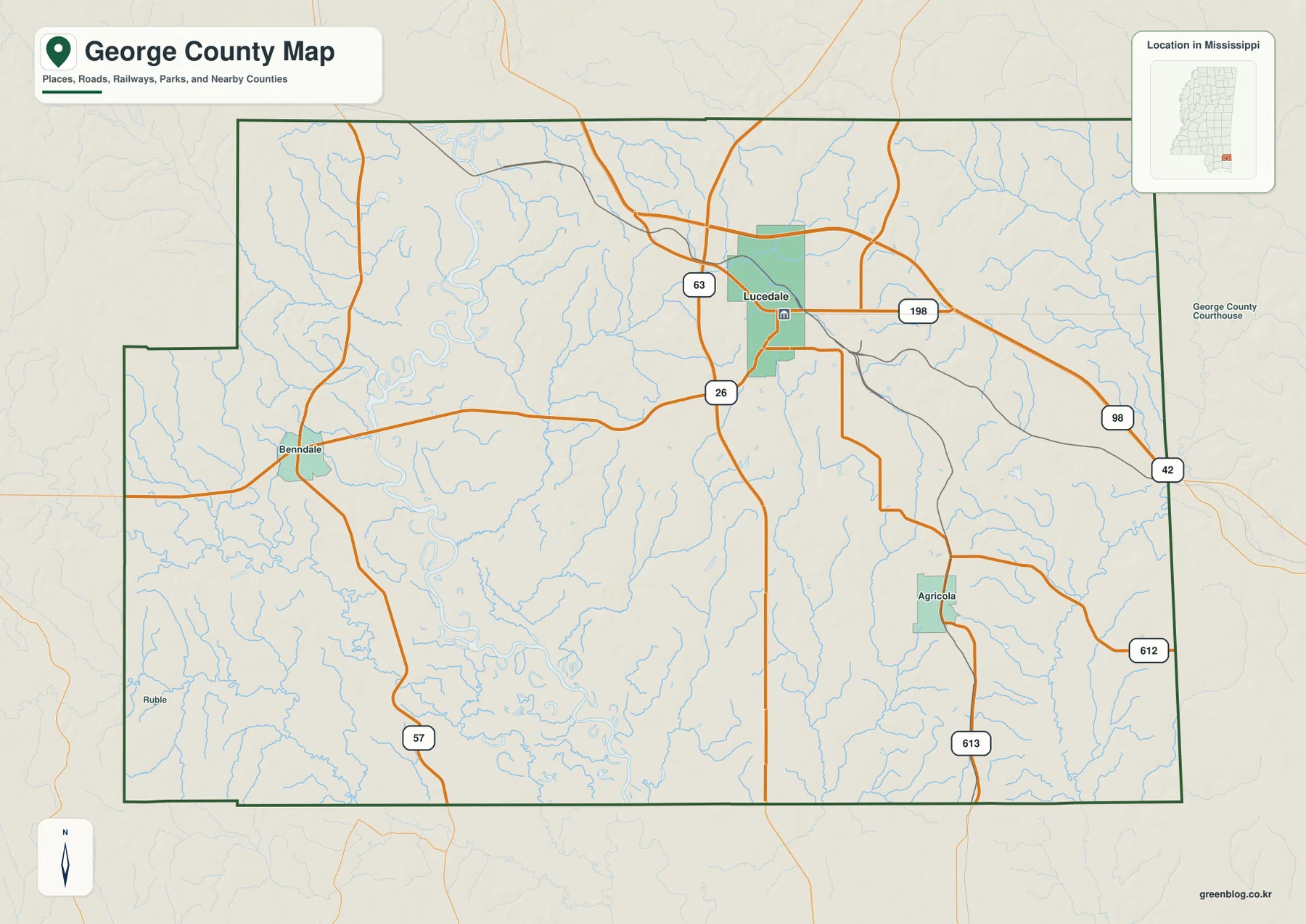
Benndale appears west of Lucedale along the MS 26 corridor, with MS 57 continuing south from the western part of the county. Agricola is farther southeast, where local routes including MS 613 connect the southeastern interior. On the eastern edge, US 98 continues toward Alabama. The road map therefore shows a county whose main paved routes radiate from the northeastern half while large sections of the south and west have fewer labeled settlements.
The county outline is not a simple rectangle. A pronounced step appears on the western side, and the southwestern boundary also changes direction before reaching the southern edge. The eastern boundary is comparatively straight, reflecting the state-line side of the county. Lucedale sits noticeably closer to the north and east edges than to the southwestern corner, an important detail if you are using the map to describe the county’s overall shape rather than just its county seat.
Why the City Index Highlights Only Lucedale
The city distribution map uses a ranked major-city format, and George County has only one city listed under that definition: Lucedale. The city index shows Lucedale in the number-one position with a population label of 2,995. Places such as Benndale and Agricola still matter on the general map, but they are not presented as ranked major cities on this particular product. Using the two maps together helps separate local place names from the map’s narrower “major city” category.
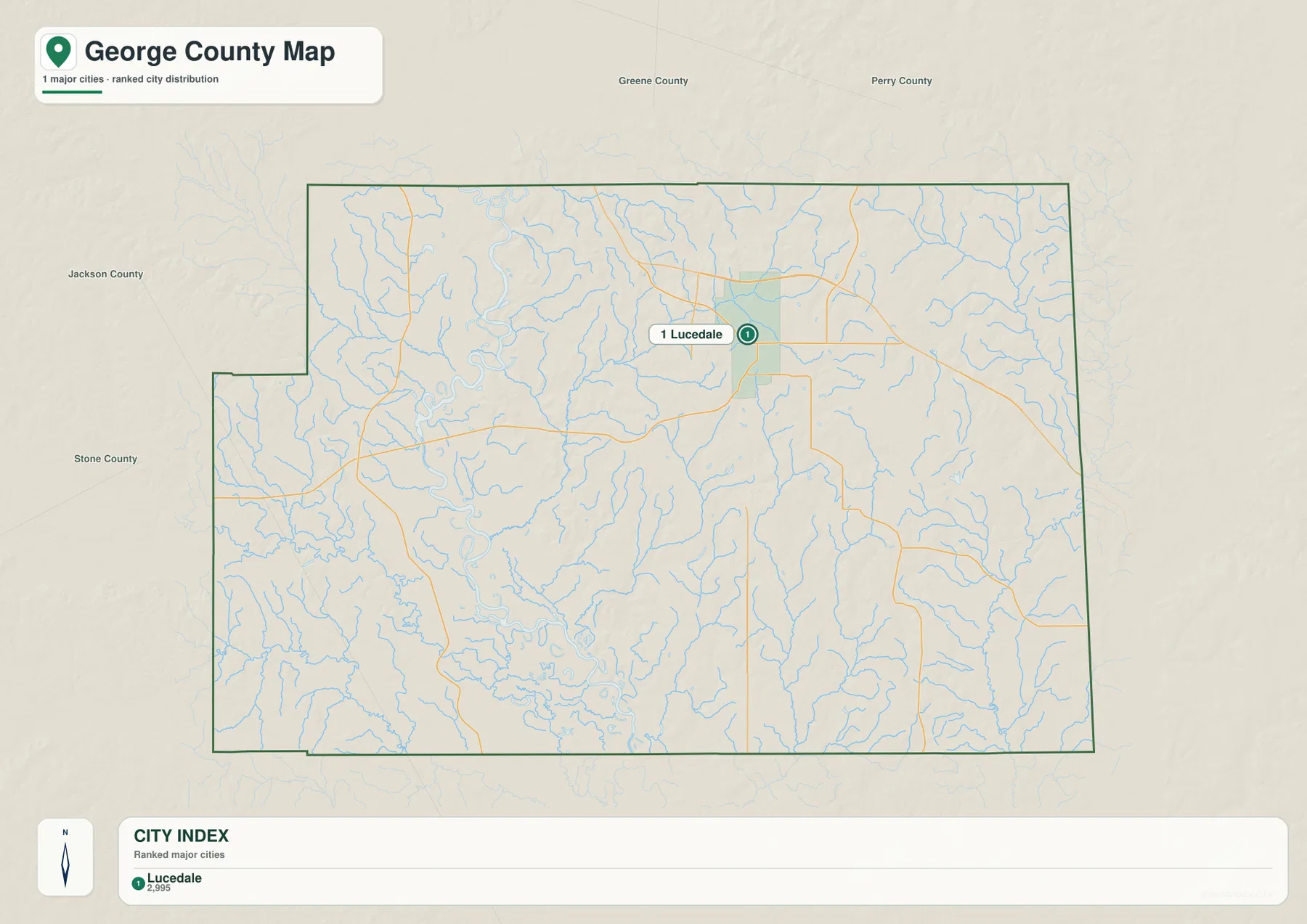
Neighboring county names provide useful orientation around the frame. Greene County and Perry County are labeled to the north, while Jackson County and Stone County appear on the western side. The east is the Alabama side of the county rather than another Mississippi county. The map also makes clear that Lucedale is not centered inside the county polygon; it is set well toward the northeast, leaving a much larger expanse of rural land to the south and west.
Unlike city-connection maps that print mileage lines between several places, this George County version is primarily about city ranking and position. There is no need to infer driving distance from it. It works best when you want a clean map showing where the county’s principal city lies, especially when paired with the road map to explain why so many of the labeled highways concentrate in the same general area.
From the Pascagoula River Lowlands to the Escatawpa River
The terrain and water map changes the visual emphasis completely. The Pascagoula River is the dominant large river on the western side, with the Leaf River and Chickasawhay River labeled farther north. Big Creek runs through the central part of the county toward the western river system, while the Escatawpa River follows the eastern side. Between these named waterways, a dense network of smaller streams branches across the county.
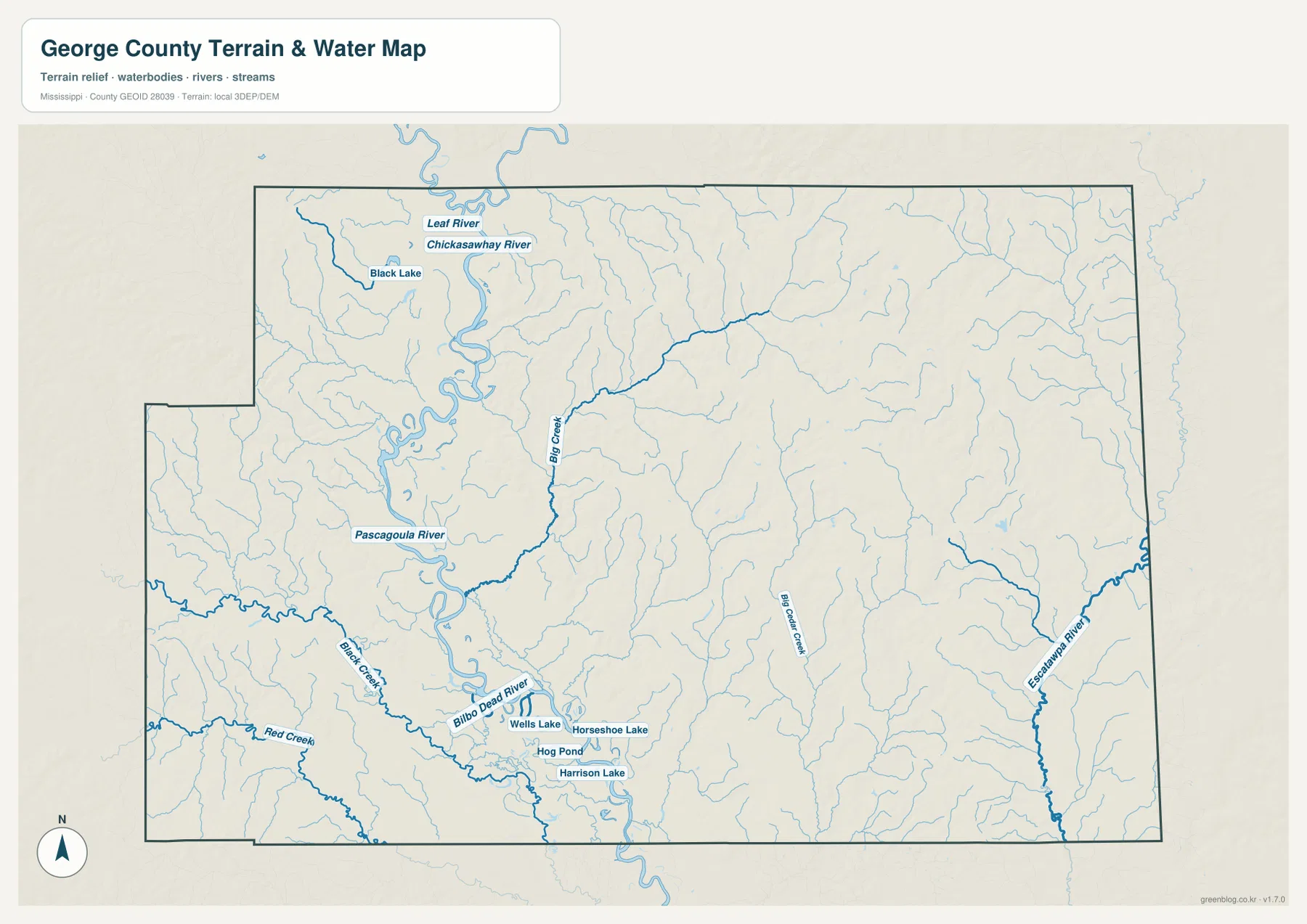
Several lakes and quiet-water features are also labeled. Black Lake lies toward the northwest, and Wells Lake, Horseshoe Lake, Harrison Lake, and Hog Pond appear in the southern part of the map near the Pascagoula system. Bilbo Dead River is labeled near the lower western river corridor. These features occupy only a small fraction of the county’s total area, but visually they show how strongly streams and low valleys shape the landscape.
This map should be read as a county-scale water reference, not as a flood-risk, navigation, or parcel-boundary map. It does not tell you whether a specific property floods, how deep a river is, or whether a waterway is navigable. Its value is in showing the relative position of the major rivers and the many tributaries that cut through the county, especially the contrast between the wide Pascagoula corridor and the more tightly branched drainage to the east.
A 6–99 Meter Elevation Range Across Low Valleys and Eastern Hills
The elevation map reports an actual range of about 6 to 99 meters, with a mean elevation of roughly 39 meters. George County has no high mountains, yet the color and shaded relief reveal a strong internal contrast. Broad green lowlands dominate the western and west-central river corridor, while tan and brown ridges become more common in the northeast and eastern half of the county.
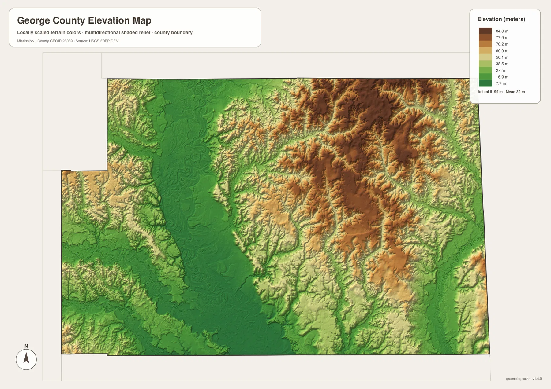
The most obvious low area is the wide north–south green belt in the western half. Comparing it with the water map shows that this low ground generally follows the Pascagoula River and connected waterways. East of that belt, the surface becomes more broken by short ridges and stream valleys. The northeastern section contains some of the darkest high-elevation colors on the map, while the far eastern Escatawpa corridor drops back into lower terrain.
The elevation product is intended for county-wide comparison rather than survey or engineering work. It can show which parts of George County are broadly lower or higher, but it should not be used to determine a building-pad elevation, road grade, or precise site measurement. For classroom or regional explanation, however, it clearly demonstrates why the western river corridor looks so different from the hilly terrain east of it.
Population, Area, and What the Maps Add to the Numbers
- County seat: Lucedale
- Places labeled on the general map: Lucedale, Benndale, Agricola, Ruble
- 2020 Census population: 24,350
- July 2025 population estimate: 26,331
- 2025 Gazetteer area: 478.699 sq mi land and 4.954 sq mi water
- 2020 population per land square mile: about 50.9
- Major roads: US 98, MS 26, MS 57, MS 63, MS 198, and others
- Elevation-map range: about 6–99 m, mean 39 m
The population and area figures provide useful context, but they do not describe where residents actually live. Dividing the 2020 population by the land area gives about 50.9 residents per square mile. The maps show why that average should not be treated as an even distribution: Lucedale has the strongest concentration of roads and city labeling, while the southern and western parts of the county contain much larger rural areas with rivers, tributaries, and fewer named settlements.
The July 2025 estimate of 26,331 and the 2020 Census count of 24,350 come from different reference dates, so they should be kept distinct. The Gazetteer also separates land from water area. Even though water accounts for only a small share of total acreage, the Pascagoula River, Escatawpa River, Big Creek, and many smaller streams are far more important to the shape of the terrain than the water-area percentage alone would suggest.
Choosing the Map That Best Fits Your Question
Use the general county map when you need Lucedale, Benndale, Agricola, the county outline, or major road numbers. The city map is cleaner when the main question is simply where Lucedale sits within George County. For rivers, lakes, and tributaries, the water map removes most road detail and makes the Pascagoula and Escatawpa systems easier to follow. The elevation map is the best choice for comparing the broad western lowland with the higher and more dissected ground to the east.
For a presentation, a useful sequence is to begin with the road map and then add either the water or elevation map. Showing US 98 and Lucedale first gives the audience a familiar orientation; the second map can then explain the physical landscape around those roads. If the topic is natural geography, pairing the water and elevation maps makes the relationship between the Pascagoula lowlands and the higher eastern ridges especially clear.
The WebP images in the article are optimized for on-screen viewing. If you need larger files for printing, cropping, slide design, or offline reference, the download below contains the corresponding high-resolution JPG versions in one ZIP archive.
Frequently Asked Questions
Is Lucedale in the center of George County?
No. The maps place Lucedale well toward the northeastern part of the county. It is the main road and city reference point, but a much larger rural area extends south and west toward the Pascagoula River system.
Which rivers stand out most on the George County water map?
The Pascagoula River is the broadest major river on the western side, while the Escatawpa River marks the eastern water corridor. Big Creek runs through the central part of the county, and many smaller tributaries spread between the two larger river systems.
Is George County flat or hilly?
It has both low and hilly terrain. The elevation map ranges from about 6 to 99 meters. Western river lowlands are relatively flat and low, while the eastern and northeastern portions contain more closely spaced ridges and higher ground.
Map File Information
The George County county map, city map, water map, and elevation map are packaged as high-resolution A3-format JPG files. Download the ZIP below when you need larger originals for printing, editing, classroom materials, or presentations.
- Included Files: county map, city map, water map, elevation map
- File Type: ZIP containing 4 JPG files
Related Maps
- Abbeville, Headland, and Lake Eufaula on the Henry County Alabama Map
- Athens to Wheeler Reservoir on the Limestone County Alabama Map
- Autauga County Alabama Land Cover Map
Sources and References
- U.S. Census Bureau QuickFacts – George County, Mississippi
- U.S. Census Bureau Gazetteer Files
- Mississippi Department of Transportation Official Highway Map
- USGS National Hydrography
- USGS 3D Elevation Program
- Mississippi Encyclopedia – George County
Green Map creates custom-edited map images using open geographic data sources such as geoBoundaries, Natural Earth, OpenStreetMap, and government open data. These maps are edited visual materials, not raw data files, and are provided for education, documents, presentations, and graphic reference.