Newton County stretches north from Kentland and Goodland through Brook and Morocco toward Lake Village and the Roselawn side of the county. You can download the high-resolution JPG ZIP directly from this page. The larger originals are useful for reading road shields, settlement names, ditch labels, and elevation shading. This Newton County Indiana Map page combines the long north–south road pattern with a five-place city index, Iroquois River and the Willow Slough water features, and a 162–271 meter relief surface.
Kentland is the best southern reference because it is the county seat and sits near U.S. 41 and U.S. 52. Goodland lies farther east along the southern tier, while Brook and Morocco form a sequence up the middle and western side. The northern county becomes more irregular in shape around Lake Village, Sumava Resorts, Thayer, and Roselawn. Using those place names together makes the unusual length and changing boundary much easier to understand.
Water is just as important for orientation. Iroquois River crosses the south, while J.C. Murphey Lake, Cory Lake, and Beaver Creek provide a separate west-central set of landmarks. The north is crossed by long ditches that resemble the agricultural road grid more than a natural meandering river system. The elevation legend reports an actual range of about 162 to 271 meters and a mean of 205 meters, with low northern ground and the Iroquois valley separated from higher pockets across the middle, east, and far south.
Table of Contents
Roads connect Kentland and Goodland to Brook, Morocco, and the northern county
Kentland has one of the clearest developed footprints on the general map and occupies the southern part of the county close to U.S. 41 and U.S. 52. Those routes create a strong reference for the county seat. Goodland lies farther east near U.S. 24, while Route 71 provides another southern-edge cue. Starting here makes the long northward transition through mostly rural terrain much easier to follow.
Brook appears north of Kentland near Route 16, and Morocco lies farther north along Route 114. Mount Ayr is a very small eastern reference near the Route 55 and 500-road side. Across this middle part of the county, the road network is more prominent than the settlement footprints, so numbered east–west lines and long north–south roads become useful orientation tools.
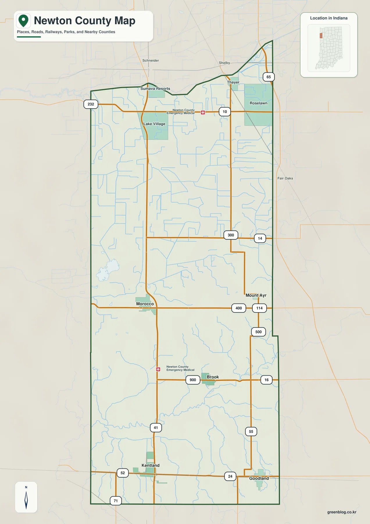
Farther north, Routes 14 and 300 cross the central-northern county, while Route 10 runs through the Lake Village side. Sumava Resorts sits near the irregular northwestern boundary. Thayer and Roselawn provide northeastern references close to the I-65 side. With fewer large towns in this section, local roads, drainage lines, and the changing county outline become increasingly important.
The county shape itself is worth noticing. Newton County is relatively regular across much of the south but becomes stepped and angled toward the north, with an extension toward the northeast. Pairing Kentland and Goodland with Lake Village and Roselawn gives a simple mental picture of that geometry before the map is used for smaller roads or waterways.
The five-place index compares Kentland, Morocco, Brook, Goodland, and Mount Ayr
The supplied city index highlights five places. Kentland is printed at 1,828, Morocco at 1,040, Brook at 900, Goodland at 792, and Mount Ayr at 90. These figures belong to the supplied map edition rather than a live demographic feed. Their main value here is spatial: Kentland and Goodland define the south, Morocco marks the middle-west, Brook the south-central interior, and Mount Ayr the eastern middle.
| Rank | Place | Value printed on map | Position |
|---|---|---|---|
| 1 | Kentland | 1,828 | Southwest |
| 2 | Morocco | 1,040 | West-central |
| 3 | Brook | 900 | South-central |
| 4 | Goodland | 792 | Southeast |
| 5 | Mount Ayr | 90 | East-central |
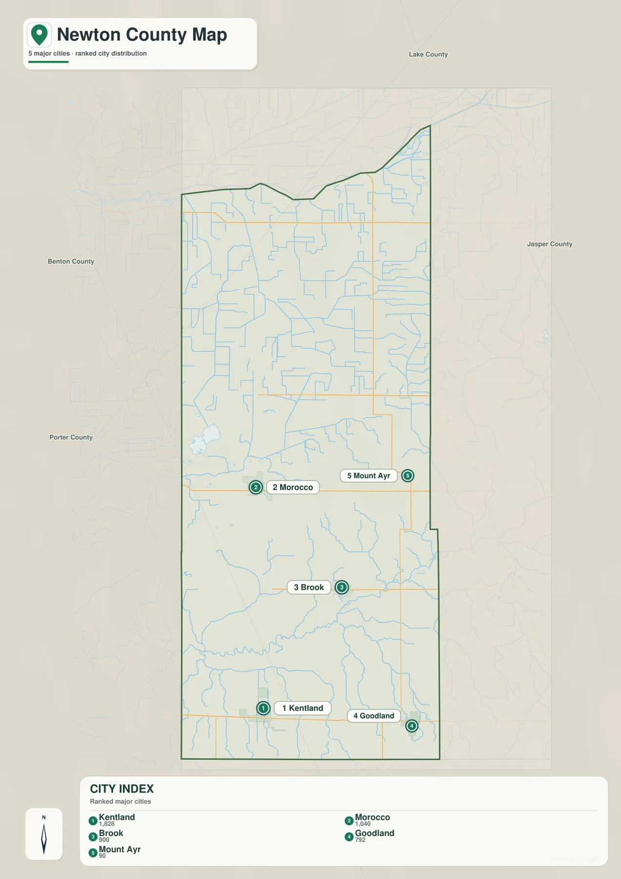
The index also shows how far apart the highlighted places are. Kentland and Morocco are separated by a large rural interval, while Brook sits farther east and south between the two broader county zones. Goodland shares the southern tier with Kentland but is well to the east. Mount Ayr is much smaller and is easiest to relocate by returning to the detailed road map.
Lake Village, Roselawn, Thayer, and Sumava Resorts do not appear in the five-place index even though they are useful northern map labels. Use the general map whenever the northern communities, I-65 side, or county roads matter. Use the index when the goal is simply to compare the five highlighted settlement values. Current population analysis should rely on a current official source rather than the printed index alone.
Iroquois River defines the south while Willow Slough adds lakes, wetlands, and ditches to the west-central county
Iroquois River is the strongest named water feature in the southern part of the terrain-and-water map. It enters from the west, bends across the county, and continues east through a broad low corridor. Montgomery Ditch and Barton Ditch appear nearby, reinforcing the mix of natural river bends and straighter drainage channels that characterizes the lower county.
West-central Newton County has a different water signature. J.C. Murphey Lake and Cory Lake sit near Beaver Creek, creating a recognizable lake-and-wetland cluster. Indiana DNR describes J.C. Murphey Lake as the center of the Willow Slough Fish & Wildlife Area wetland complex. The agency also notes rolling dunes, oak savanna, and forest around the property, adding useful context to a part of the county that looks very different from the open ditch network farther north.
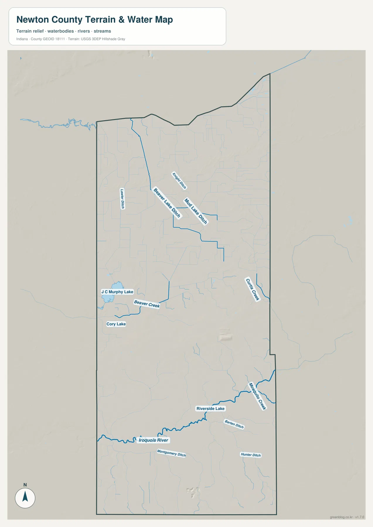
The north is dominated by long drainage features such as Beaver Lake Ditch and Mud Lake Ditch. Their straight segments contrast with the curves of the Iroquois River and Beaver Creek. Curtis Creek provides a more natural-looking meandering line on the eastern side of the county. Together, these waterways show why a road map alone does not fully explain the county’s rural landscape.
This Newton County water image is for geographic orientation and terrain reference. It does not establish flood risk, current water levels or quality, navigation rights, property ownership, or legal water boundaries. Those questions require the appropriate current USGS, FEMA, Indiana DNR, or local source.
The 162–271 m surface separates low northern ground and the Iroquois valley from higher interior ridges
The supplied elevation legend reports an actual Newton County range of about 162 to 271 meters and a mean of 205 meters. The northern tip is broadly green and low, and the Iroquois River creates another low corridor through the south. Across the middle and east, the surface rises into lighter greens, yellows, and localized brown high ground.
The middle of the county is not uniformly flat. Higher ridges and knolls appear in bands, especially toward the east-central interior, while narrow drainage lines remain lower. This difference is easy to miss on the road map because the agricultural road grid looks regular, but the elevation view reveals a more varied surface beneath it.
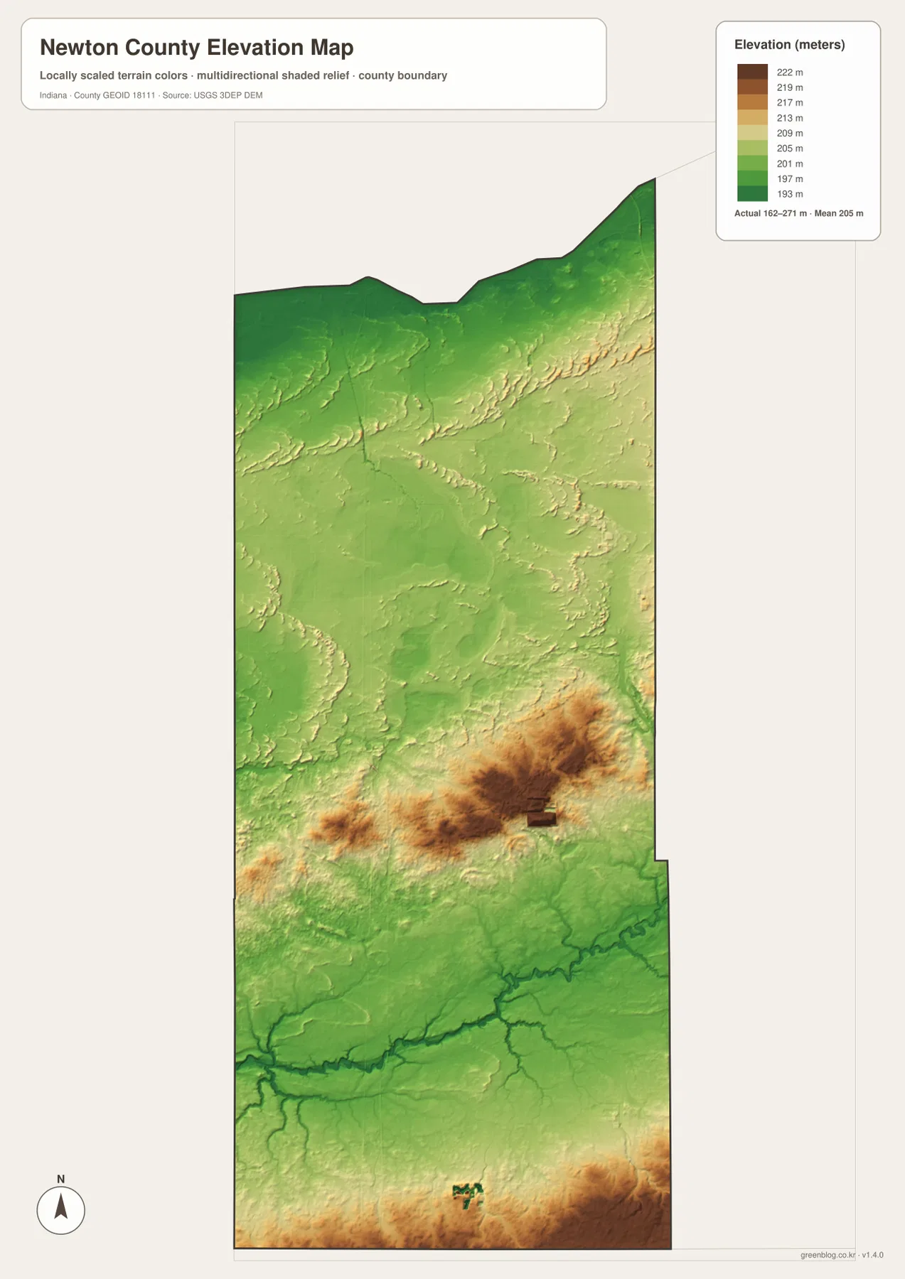
South of the main river corridor, the terrain rises again toward parts of the county boundary. That change keeps the Kentland–Goodland side from reading as one perfectly level floodplain. The low river route remains easy to follow, but areas away from the channel shift into higher yellow and brown tones.
Indiana DNR’s Willow Slough description is also useful context because it identifies rolling dunes along with wetlands, oak savanna, and forest in the property landscape. The county-scale elevation map should still be used only for relative comparison. For a Newton County parcel, road grade, drainage design, or construction project, consult original terrain data such as the USGS 3D Elevation Program or a qualified survey.
Start at Kentland, then connect the Iroquois valley to Willow Slough and the long northern road grid
For settlements and roads, begin at Kentland near U.S. 41 and U.S. 52. Move east to Goodland, then work north through Brook and Morocco before adding Lake Village and Roselawn. That sequence turns the county’s elongated outline into a simple south-to-north framework and makes the smaller road labels easier to place.
The city index is useful for comparing Kentland, Morocco, Brook, Goodland, and Mount Ayr without the dense road and drainage network. Kentland has the largest printed value, Morocco marks the middle-west, and Brook and Goodland divide the southern half. For Lake Village, Roselawn, and other northern labels, the general map remains the better choice.
For physical geography, find Iroquois River first and then add J.C. Murphey Lake, Beaver Creek, Curtis Creek, and the northern ditches. Switching to the elevation view at those same locations shows the broad lowlands in green and the higher interior ground in yellow and brown. This comparison connects settlement, drainage, wetland, and relief patterns without treating the county as one uniform plain.
The WebP images on this page are reduced previews. The Newton County archive contains four original 2572×3638-pixel JPG files covering the general county map, city index, terrain-and-water map, and elevation map. The larger originals are better for printing or reading small place, road, creek, ditch, and water labels.
A useful comparison is to keep Kentland and Morocco fixed as two reference points. Find Brook and Goodland on the general map, compare the five highlighted places on the city index, move to the water view to locate Iroquois River and J.C. Murphey Lake, and finish on the elevation image by comparing the low river corridor with the higher interior terrain.
Frequently Asked Questions
What is the county seat of Newton County?
Kentland is the Newton County seat. On the supplied map it sits in the southern part of the county near U.S. 41 and U.S. 52, and it also carries the largest value in the five-place city index.
Which water features are easiest to recognize?
Iroquois River is the strongest southern reference, while J.C. Murphey Lake and Cory Lake mark the west-central county. Beaver Creek and Curtis Creek provide additional natural channels, and the north contains several long ditches. This water view is for orientation rather than flood, parcel, or legal-boundary decisions.
Can the 162–271 m elevation range be used for exact site measurements?
No. The image gives a county-wide range with a mean of 205 meters and is intended for comparing low northern ground and the Iroquois River corridor with higher interior terrain. Precise property or engineering work requires original elevation data or professional survey measurements.
Map File Information
The Newton County ZIP combines the general road-and-place map, five-place city index, terrain-and-water map, and elevation map as full-resolution JPG originals.
- File Type: ZIP containing four 2572×3638px JPG files
Related Maps
Sources and References
The article is based primarily on the supplied Newton County map set and asset manifest. The following official sources provide county, Willow Slough, boundary, hydrography, and elevation context.
- Newton County, Indiana – official county government information and Kentland administrative context
- Indiana DNR – Willow Slough Fish & Wildlife Area – official information on J.C. Murphey Lake, wetlands, dunes, savanna, and forest
- U.S. Census Bureau TIGER/Line Shapefiles – boundary reference for Newton County and its place framework
- USGS National Hydrography – reference data for Iroquois River, creeks, ditches, and mapped water features
- USGS 3D Elevation Program – source terrain data for detailed elevation work
Green Map creates custom-edited map images using open geographic data sources such as geoBoundaries, Natural Earth, OpenStreetMap, and government open data.
These maps are edited visual materials, not raw data files, and are provided for education, documents, presentations, and graphic reference.