Dodge County sits in central Georgia around Eastman, with small cities spread toward the north and south, a road network that converges near the county seat, and many creeks cutting across the interior. The map set on this page is designed to make those relationships easy to see without turning the page into a technical GIS report. You can compare the county boundary and roads, the relative placement of five mapped cities, named waterways such as Gum Swamp Creek, and the county’s elevation pattern. The four original maps are also available together as high-resolution A3 JPG files in one ZIP download.
Eastman is the best starting point for reading the county. Chester lies to the north, Chauncey is southeast of Eastman, Milan is farther south near the southeastern side of the county, and Rhine is in the southwest. The general county map also labels Empire in the northwest. Once those places are located, the water and elevation maps add another layer of context: the county contains a dense web of small streams, and many of the greener low areas on the elevation map follow creek valleys rather than city boundaries or road lines.
Table of Contents
Dodge County boundary, Eastman, and the road network
The county outline is long from north to south, with an irregular southwestern edge and a narrow extension reaching eastward. The city-distribution map provides the neighboring-county labels that make this outline easier to place: Laurens County is north, Pulaski County is northeast, Wheeler County is east, Ben Hill County is southeast, Wilcox County is southwest, Bleckley County is west, and Telfair County is northwest. These labels are useful when the goal is to understand where Dodge County sits within central Georgia rather than simply recognize its shape.
Eastman appears near the center of the county and functions as the main visual anchor. Several numbered roads meet or pass through the Eastman area, making the city easy to find even before reading its label. The map also marks Middle Georgia State University just east of Eastman and the Dodge County Sheriff’s Office near the city, giving readers two additional reference points. Those markers are especially helpful when the map is used in a presentation or local-orientation document where a city dot alone would provide too little context.
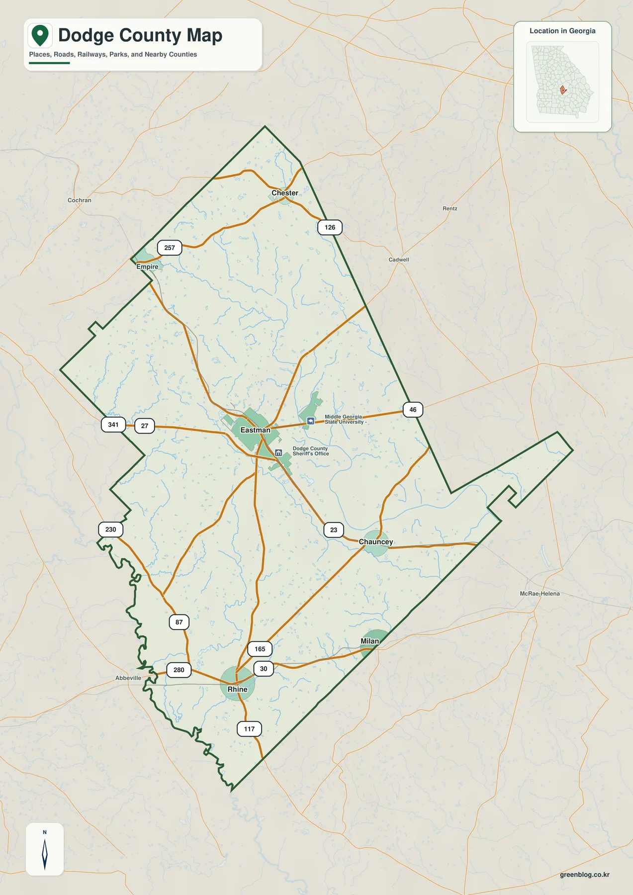
The road labels help explain how the mapped communities relate to Eastman. Numbers 341 and 27 enter the central area from the west, while 23 continues toward Chauncey on the southeastern side. Route 46 runs east from the Eastman area, and 87 heads southwest. In the north, 257 and 126 appear around Empire and Chester. The southern part of the map includes 165, 30, 280, and 117 around the Rhine–Milan area, while 230 is shown near the southwestern side. This is a county reference map, not a turn-by-turn navigation product, so current routing, road closures, and local-street details should still be checked with a current road service.
Five mapped cities from Chester to Rhine
The city map removes much of the extra road detail and makes the settlement pattern easier to compare. Eastman is the central and largest mapped place, Chester occupies the northern part of the county, Chauncey sits to the southeast, Milan is farther south near the southeastern boundary, and Rhine is in the southwest. The five locations are not clustered along one narrow strip. Instead, they show a county in which Eastman is the main center while smaller cities are distributed in several directions around it.
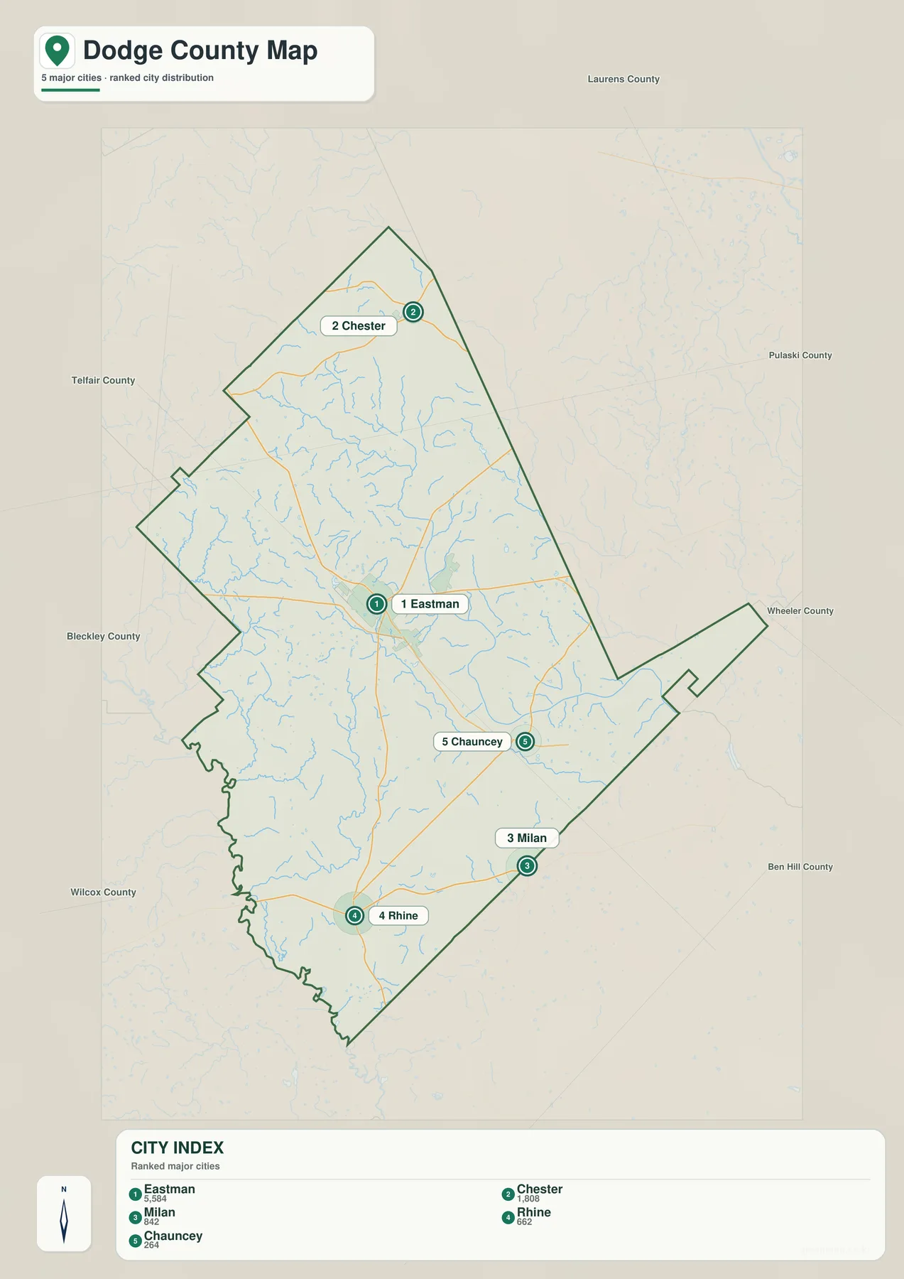
The CITY INDEX printed at the bottom of the supplied map lists Eastman at 5,584, Chester at 1,808, Milan at 842, Rhine at 662, and Chauncey at 264. Those figures should be read as the values printed on this particular map; readers who need the newest population estimate should check the Census link in the source section. Even without treating the numbers as a current census table, the index is useful because it shows the clear size difference between Eastman and the other four mapped cities.
For local orientation, direction matters as much as rank. Chester provides a reference for the northern part of the county, while Chauncey shows the southeastern side of the Eastman area. Milan and Rhine are both in the southern half, but they are separated from each other: Milan lies closer to the southeastern boundary and Rhine lies to the southwest. That distinction is useful for classroom exercises, local-history notes, or any page that needs to describe where the smaller cities sit without crowding the text with every local road.
Gum Swamp Creek and a dense network of smaller waterways
The water map changes the emphasis completely. Instead of towns and highways, it shows a county crossed by many small streams. Gum Swamp Creek is one of the most prominent named waterways through the central and southeastern interior, while Little Gum Swamp Creek enters from the north. Sugar Creek is labeled farther south, and Crooked Creek and Cypress Creek appear in the southern half. Mosquito Creek is visible in the western interior, while Alligator Creek follows part of the eastern side. Numerous unnamed or smaller tributaries fill the spaces between those larger labels.
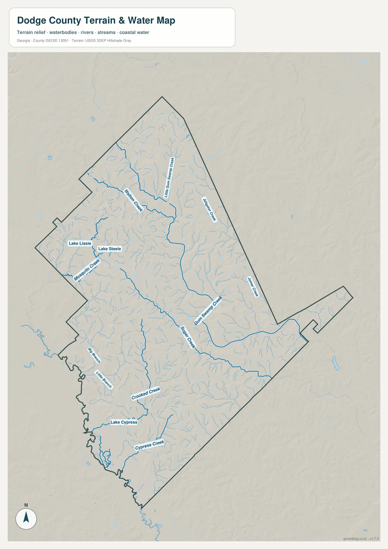
Several small lakes are also labeled. Lake Lissie and Lake Steele sit in the western part of the county, while Lake Cypress is farther south and close to the Cypress Creek system. Their small size compared with the county does not make them unimportant on a reference map; a named lake can be a useful landmark when matching the water map to the county boundary or to nearby roads on the general map. The water layer also makes clear that much of Dodge County’s drainage is carried by creeks rather than by one large river dominating the entire county.
This map should not be used as a flood-risk, parcel-boundary, or navigation map. It shows water features and terrain context, but it does not determine whether a property is inside a regulated flood zone, whether a stream is navigable, or where a legal property line sits. For those questions, readers need the specific official product designed for the task. Here, the practical value is geographic: it shows where named waterways lie and how the tributaries spread across the county.
Low creek valleys between higher ridges
The elevation map reveals more relief than the simple road map suggests. Brown and tan areas mark the relatively higher ground, especially across parts of the north and western interior, while green areas identify lower terrain. The broadest low area is visible toward the southwest, and narrow green corridors extend along major drainage paths through the middle and east. This creates a repeated ridge-and-valley texture rather than a uniformly flat surface.
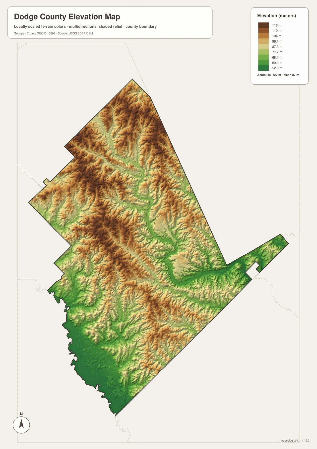
The legend reports an actual elevation range of about 48 to 127 meters, with a mean of 87 meters. The displayed color scale is locally stretched, with labeled steps from roughly 52.3 to 116 meters, so modest differences within the county are easier to see. That local scaling is useful for regional comparison, but it does not turn the image into an engineering survey. A precise elevation for a building site, road design, drainage structure, or other technical project should come from source elevation data or a professional survey.
Reading the elevation map beside the water map is particularly helpful. Gum Swamp Creek and several tributaries tend to occupy greener, lower corridors, with tan or brown ridges rising between them. The southwest corner contains a larger low area, while the northern half shows more closely spaced ridges and narrow valleys. The relationship is visible without needing specialized terminology: water generally follows the lower ground, and the shaded-relief map makes those lower paths easier to recognize.
Choosing the right Dodge County map for the task
The general county map is the best first choice when a reader needs Eastman, the county outline, nearby communities, and major numbered roads on one page. The city map is cleaner when the question is simply where the five mapped cities sit in relation to each other. The water map is better for finding named creeks and small lakes, while the elevation map adds the height differences that are mostly invisible on the other three images. Using the maps for different questions keeps each image readable and prevents one map from becoming overloaded with labels.
For a school project, for example, a student could use the city map to explain why Eastman is a central reference point and then use the water map to show how many creeks cross the county away from the city labels. A local-history page might prefer the county map for roads and place names, then add the elevation map when discussing the physical setting. A traveler who only wants road directions should use a live navigation service instead, because these static maps are designed for geographic reference rather than real-time routing.
The earlier Dodge County page also notes that the county was established in 1870. That historical fact can provide background, but this page keeps the emphasis on what is actually visible in the supplied map set. Readers who need current population figures, formal planning information, boundary data, hydrography, or source elevation data can follow the official references below instead of assuming that every detail is encoded in the map image itself.
Frequently Asked Questions
Which map is best for comparing Eastman with the smaller cities?
Use the city map first. It places Eastman, Chester, Milan, Rhine, and Chauncey on a simplified county view, making their relative positions easy to compare. The general county map is the better follow-up when you also need numbered roads and additional landmarks.
Can the water map be used to determine flood risk?
No. It is a reference map for the location of creeks, tributaries, and small lakes. Flood zones, insurance decisions, and property-specific risk require current official flood information made for those purposes.
What does the 48–127 meter elevation range mean?
The range printed on the map describes the approximate actual elevation spread represented across Dodge County. It is useful for comparing higher ridges with lower creek valleys, but it is not a survey-grade measurement for an individual property or construction site.
Map File Information
Dodge County A3 high-resolution map files
- Included Files: County map, city map, water map, and elevation map
- File Type: One ZIP containing four high-resolution A3 JPG files
- Intended Use: Printing, education, presentations, local orientation, and map-based projects
Related Maps
Sources and reference data
These official resources are useful for checking current statistics or reviewing the boundary, planning, hydrography, and elevation data behind a county reference page.
- U.S. Census Bureau QuickFacts for Dodge County
- Georgia Department of Community Affairs Dodge County comprehensive-plan page
- U.S. Census Bureau TIGER/Line Shapefiles
- USGS National Hydrography
- USGS 3D Elevation Program
Green Map creates custom-edited map images using open geographic data sources such as geoBoundaries, Natural Earth, OpenStreetMap, and government open data. These maps are edited visual materials, not raw data files, and are provided for education, documents, presentations, and graphic reference.