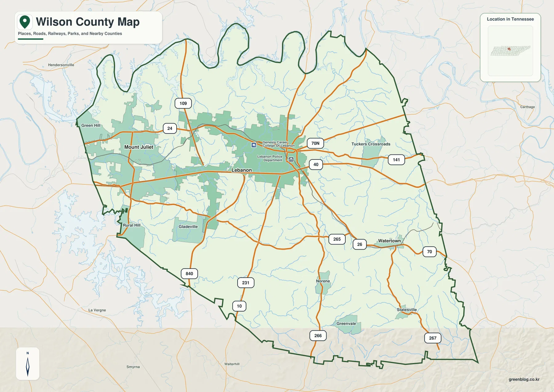
You can download the Wilson County map set on this page as a ZIP containing four high-resolution A3 JPG files. Lebanon is the central county-seat and road hub, Mount Juliet forms a large developed center in the west, and Watertown stands apart in the southeast. Along the northern boundary, the Cumberland River makes a sequence of broad bends, while the southeastern part of the county rises into noticeably higher and more dissected terrain.
The general map also labels Green Hill, Rural Hill, Gladeville, Norene, Statesville, and Tuckers Crossroads. I-40 provides the strongest east-west road reference through Mount Juliet and Lebanon, with 840, 109, 231, 70, 70N, 141, 265, 266, and 267 adding important connections. The water layer identifies Cumberland River, Cedar Creek, Bartons Creek, Spring Creek, Hurricane Creek, and other tributaries, and the elevation map spans about 135 to 413 meters with a mean near 199 meters.
Table of Contents
Lebanon, Mount Juliet, and Watertown represent three different parts of Wilson County
Lebanon is the most useful starting point on the county map because it lies near the center and is surrounded by several major roads. The map also marks Lebanon Police Department and Genesis Career College of Lebanon within the developed area, reinforcing its role as an administrative and service center. Mount Juliet lies well to the west in a much broader developed zone, while Watertown is separated in the southeast.
The western side includes Green Hill, Gladeville, and Rural Hill, and the colored developed area is much more continuous there than around Watertown. East of Lebanon, Tuckers Crossroads provides another useful orientation point, while Norene and Statesville mark the southern interior. Taken together, these places show that Wilson County contains a western urbanizing area, a central county-seat region, and a more rural southeastern landscape rather than one evenly spread settlement pattern.
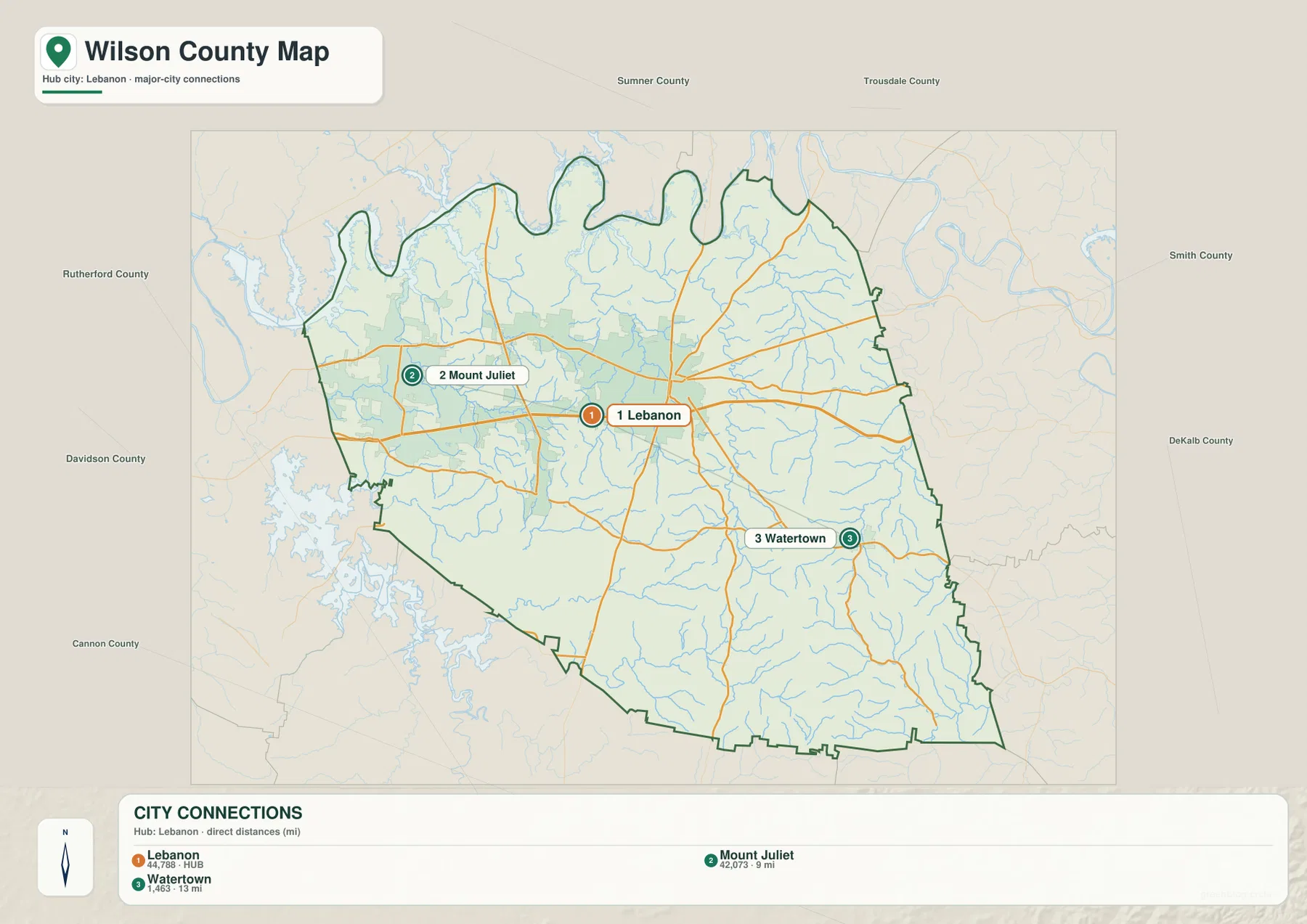
The neighboring-county directions help explain the outer edges. Sumner and Trousdale counties are to the north, Smith and DeKalb counties to the east, Cannon and Rutherford counties to the south, and Davidson County to the west. The northern boundary is especially irregular because it follows the broad Cumberland River bends rather than a simple straight line.
The city map shows a short western link and a longer southeastern connection
The supplied city-connections map uses Lebanon as the hub. It labels Lebanon at 44,788, Mount Juliet at 42,073, and Watertown at 1,463. Mount Juliet is shown about 9 miles from Lebanon by direct distance, while Watertown is about 13 miles away. Those values are designed for relative comparison on the supplied graphic, not as current official municipal estimates or driving distances.
Although both cities are fairly close to Lebanon in straight-line terms, their surroundings look very different. Mount Juliet sits inside a large western developed area with strong road links toward Davidson County. Watertown occupies a smaller southeastern center where local roads, creeks, and hills are more prominent. The city map is therefore most useful when it is read together with the general and elevation maps rather than as a distance diagram by itself.
Countywide figures add scale without replacing the map. The supplied reference material lists a 2020 census population of 147,737 and a July 2025 estimate of 175,033. Wilson County contains about 571.1 square miles of land and 12.5 square miles of water. Dividing the 2020 count by the land area gives roughly 258.7 residents per square mile, but the broad western development and the more rural southeastern hills clearly do not share one uniform density.
Cumberland River turns the northern county line into a chain of bends and coves
Cumberland River is the dominant water feature on the terrain-and-water map. Along the northwestern and northern edge, the river makes repeated broad loops and widened reaches, producing a county boundary with long projecting fingers and deep inward curves. That shoreline geometry is an important part of Wilson County’s shape and is much easier to understand on the water map than on a simple road layer.
Cedar Creek occupies the west-central drainage, with Powell Lake and Benjamin Franklin Lake nearby as smaller water references. Bartons Creek and Sinkhorn Creek run through the central interior, while Spring Creek follows a long eastern valley. Near the Watertown side, Dry Fork Creek and Round Lick Creek form additional branches. Hurricane Creek and Fall Creek are prominent farther south.
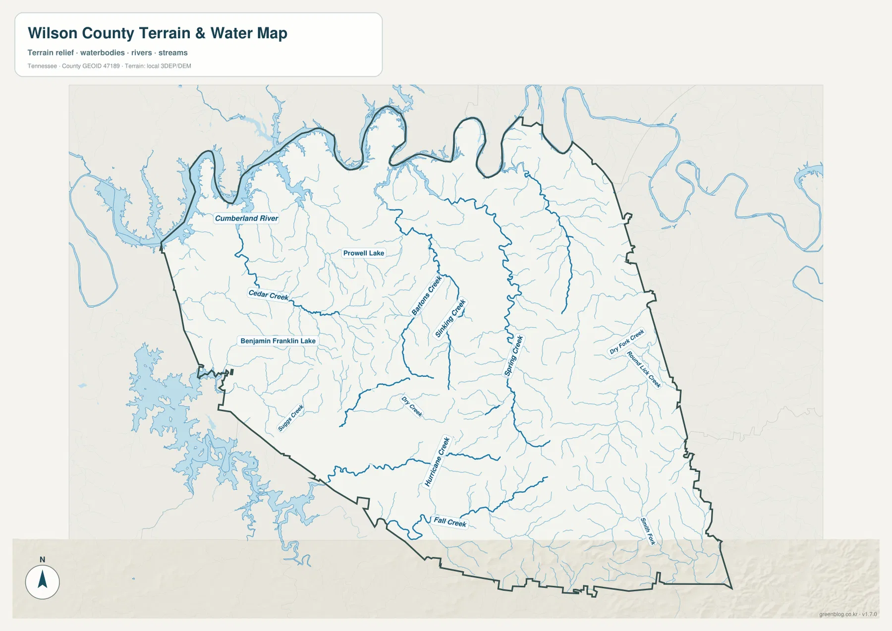
The county’s total water area is modest compared with its land area, but the location of the water matters. A broad river on the boundary and long creek valleys can influence road crossings and the practical relationship between nearby places. This is a static geographic reference rather than a live flood or boating map, so current water level, flood extent, navigation conditions, and legal property boundaries require current official sources.
Terrain rises from low western corridors to a rugged southeastern corner
The elevation map gives Wilson County an actual mapped range of about 135 to 413 meters and a mean near 199 meters. Much of the west and center appears green, including the Mount Juliet–Lebanon corridor and the low ground near the Cumberland River. Small ridges occur throughout the county, but they are generally less dominant in those areas.
The southeast is markedly different. South of Watertown and around the Statesville side, brown ridges become dense and deeply dissected, and some of the highest mapped terrain lies near the southeastern boundary. Smaller high areas also appear through the east-central interior. Spring Creek and other tributaries occupy lower green corridors between these ridges.
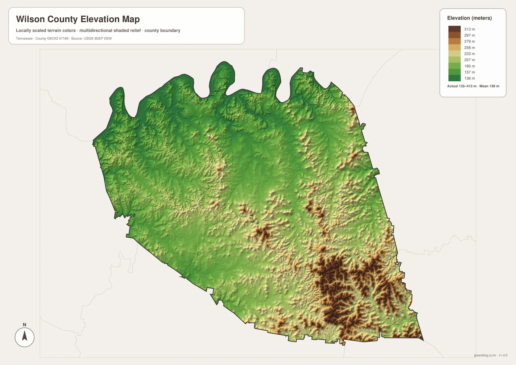
This difference in relief helps explain why the road pattern changes from west to southeast. The I-40 corridor passes through relatively open low terrain, while roads in the southeastern hills bend around ridges and follow creek valleys more closely. Parcel-level elevation, slope, or construction questions require finer source data and surveying rather than this county-scale color map.
I-40 ties Mount Juliet and Lebanon together across the lower western half
I-40 is the strongest transportation line visible on the general map. It crosses the western developed area around Mount Juliet, continues through Lebanon, and then heads east toward the county boundary. Routes 109 and 231 add important north-south connections, while 840 provides a southwestern reference and 70/70N reinforce the east-west framework.
East and southeast of Lebanon, the settlement pattern becomes less continuous. Watertown is a distinct local center around routes 70, 26, and 265, and smaller labels such as Norene and Statesville sit within a landscape of creeks and hills. The contrast between the western I-40 urban corridor and the southeastern rural relief is one of the most county-specific patterns in this map set.
The supplied county references also identify Cedars of Lebanon State Forest and Cedars of Lebanon State Park as important local landscape features south of Lebanon. They provide useful context for the transition from the central city and road network into the more open rural and natural areas of the county. Detailed entrance roads, park boundaries, or operating information should be checked with the managing agency.
A practical way to read the Wilson County map set
For settlement and transportation questions, begin with Lebanon and trace I-40 west toward Mount Juliet. Then add Watertown, Green Hill, and Gladeville to establish the outer developed and rural directions. For physical geography, start with the Cumberland River along the north and then follow Bartons Creek through the center, Spring Creek in the east, and Hurricane Creek farther south.
The elevation map becomes most useful when the southeastern brown ridges are compared with the green western and central lowlands. On a printed copy, one sheet can emphasize cities and roads while another marks river bends, creeks, and relief. Separating those purposes makes the relationships easier to see without repeating every label on the same page.
Wilson County was established in 1799, and Lebanon is the county seat in the supplied reference material. The modern map still places Lebanon at the center of the administrative and road network, but Mount Juliet’s large developed footprint gives the western side a second major urban focus. Adding Watertown and the Cumberland River completes a much more accurate county picture than treating Lebanon as the only meaningful reference.
Frequently Asked Questions
How close are Lebanon and Mount Juliet on the city map?
The supplied city map shows Mount Juliet about 9 miles from Lebanon by direct distance. I-40 connects the two urban areas, but an actual trip depends on the starting point, interchange choice, and current traffic rather than the straight-line figure alone.
Why is the northern boundary of Wilson County so irregular?
The northern edge follows large bends and widened reaches of the Cumberland River. As the river curves, the county outline develops projecting fingers and deep indentations instead of a straight line. Current flood or water-level questions require live official information.
Where is the highest terrain on the Wilson County elevation map?
The most extensive high terrain appears in the southeast and east, especially south of the Watertown area. The supplied map ranges from about 135 to 413 meters, with a mean near 199 meters, while Mount Juliet, Lebanon, and much of the Cumberland River side are lower.
Map File Information
The ZIP contains the high-resolution JPG originals for the Wilson County map, city map, water map, and elevation map shown on this page. The four A3-format images are better suited to printing, enlarged viewing, and annotation than the WebP previews in the article.
- Included Files: County map, city map, water map, and elevation map
- File Type: ZIP containing 4 JPG images
Related Maps
- Alamo to Gadsden: A Crockett County Tennessee Map
- Altamont, Monteagle, and Plateau Valleys — Grundy County Tennessee Map
- Around Chattanooga: Hamilton County Tennessee Map
Sources and References
- Tennessee State Library and Archives Wilson County fact sheet
- Tennessee Department of Transportation Wilson County map
- U.S. Census Bureau Wilson County QuickFacts
- USGS National Hydrography
- USGS 3D Elevation Program
Green Map creates custom-edited map images using open geographic data sources such as geoBoundaries, Natural Earth, OpenStreetMap, and government open data. These maps are edited visual materials, not raw data files, and are provided for education, documents, presentations, and graphic reference.