Wyandotte County sits at the eastern edge of Kansas, where Kansas City forms the dominant urban center and Bonner Springs, Edwardsville, and part of Lake Quivira occupy the western and southern edges. The Missouri River bends along the north and east, the Kansas River follows the south, and the two waterways meet at Kaw Point. I-70 and I-435 provide major regional connections through a county that combines dense urban development, industrial districts, river bottoms, wooded ravines, and large parks within a very small area. High-resolution map files are available for download in the section below.
This guide follows Kansas City, the western communities, the two major rivers, Wyandotte County Lake, and terrain ranging from about 219 to 325 meters. WebP previews are available for quick viewing, and the matching high-resolution JPG files can be downloaded together in one ZIP for printing, classroom work, or offline reference.
Table of Contents
Kansas City fills most of the county while I-70 and I-435 organize regional travel
Kansas City occupies most of the central and eastern county. I-70 crosses from the Bonner Springs side toward downtown Kansas City, while I-435 links western development areas with the northern and southern metro network. Road density increases sharply toward the east, where the county becomes part of the continuous Kansas City urban core between the Missouri and Kansas rivers.
The Kansas Historical Society identifies Kansas City as the Wyandotte County seat. Its 2020 census table also shows Kansas City accounting for most of the county population, with Bonner Springs and Edwardsville far smaller. Unified Government records explain that Kansas City, Kansas and Wyandotte County consolidated their governments in 1997, creating the administrative structure used today.
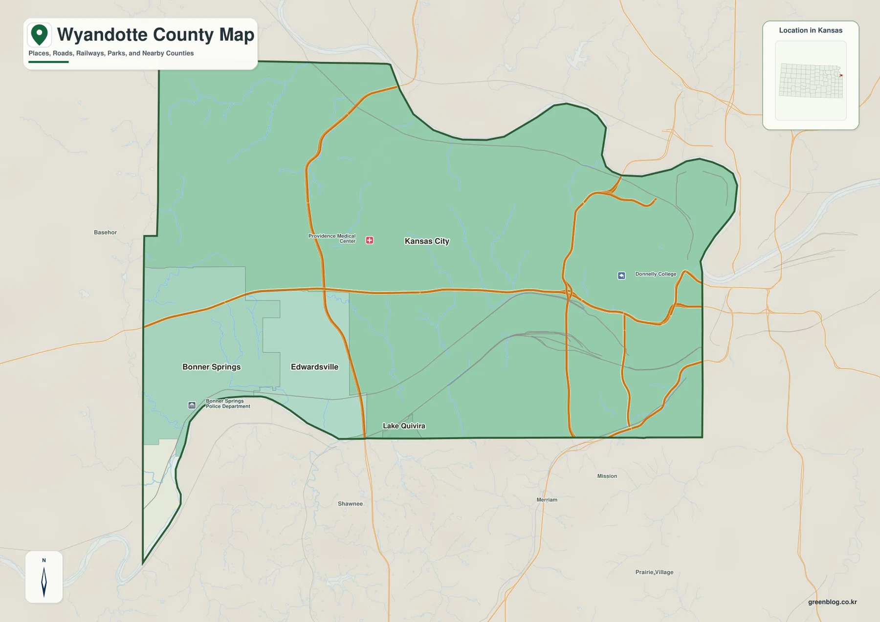
Bonner Springs and Edwardsville sit close together on the western side near the Leavenworth and Johnson county boundaries. Part of Lake Quivira appears along the southern edge, while the county’s eastern side directly borders Kansas City, Missouri. The short distance between river bottoms, urban neighborhoods, industry, parkland, and higher western ridges gives Wyandotte County an unusually compressed range of landscapes.
The city-connections panel compares Kansas City with Bonner Springs and Edwardsville
The supplied city-connections panel places Kansas City at an index value of 155,135, Bonner Springs at 7,839, and Edwardsville at 4,724. These are map index values rather than current official population estimates. The panel also labels Bonner Springs at about 7 miles and Edwardsville at about 5 miles in straight-line distance from Kansas City; those numbers are not driving distances.
The three communities sit close together but occupy different settings. Kansas City is the dense urban and industrial center, while Bonner Springs and Edwardsville represent the lower-density western side. Bonner Springs is especially close to the Kansas River bends and western hills, and Edwardsville occupies the north side of the Kansas River corridor.
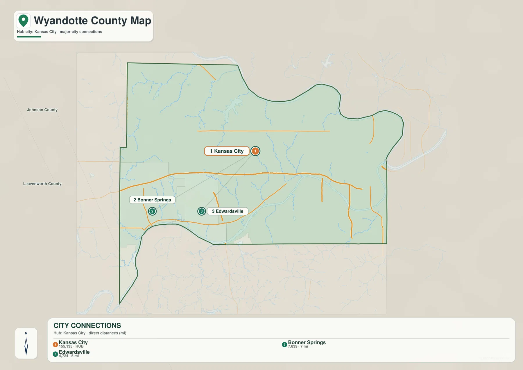
The Kansas Historical Society’s 2020 census table lists Kansas City at 156,607, Bonner Springs at 7,831, and Edwardsville at 4,717. Those official counts are close to the supplied panel values but are not the same dataset, so the map numbers should be used only for relative city context.
The Missouri and Kansas rivers define the county and meet at Kaw Point
The strongest water features are the Missouri River along the north and east and the Kansas River along the south. The Missouri sweeps through broad bends beside northeastern Kansas City, while the Kansas River enters near Bonner Springs and follows the southern edge toward downtown. Their meeting point at Kaw Point is the county’s clearest natural landmark.
A dense network of smaller creeks descends toward those rivers. Island Creek and Honey Creek drain the northwest, Connor Creek feeds the Wyandotte County Lake area, and Marshall Creek, Muncie Creek, and Mill Creek cut through the central hills. Little Turkey Creek and Turkey Creek provide additional southern drainage references.
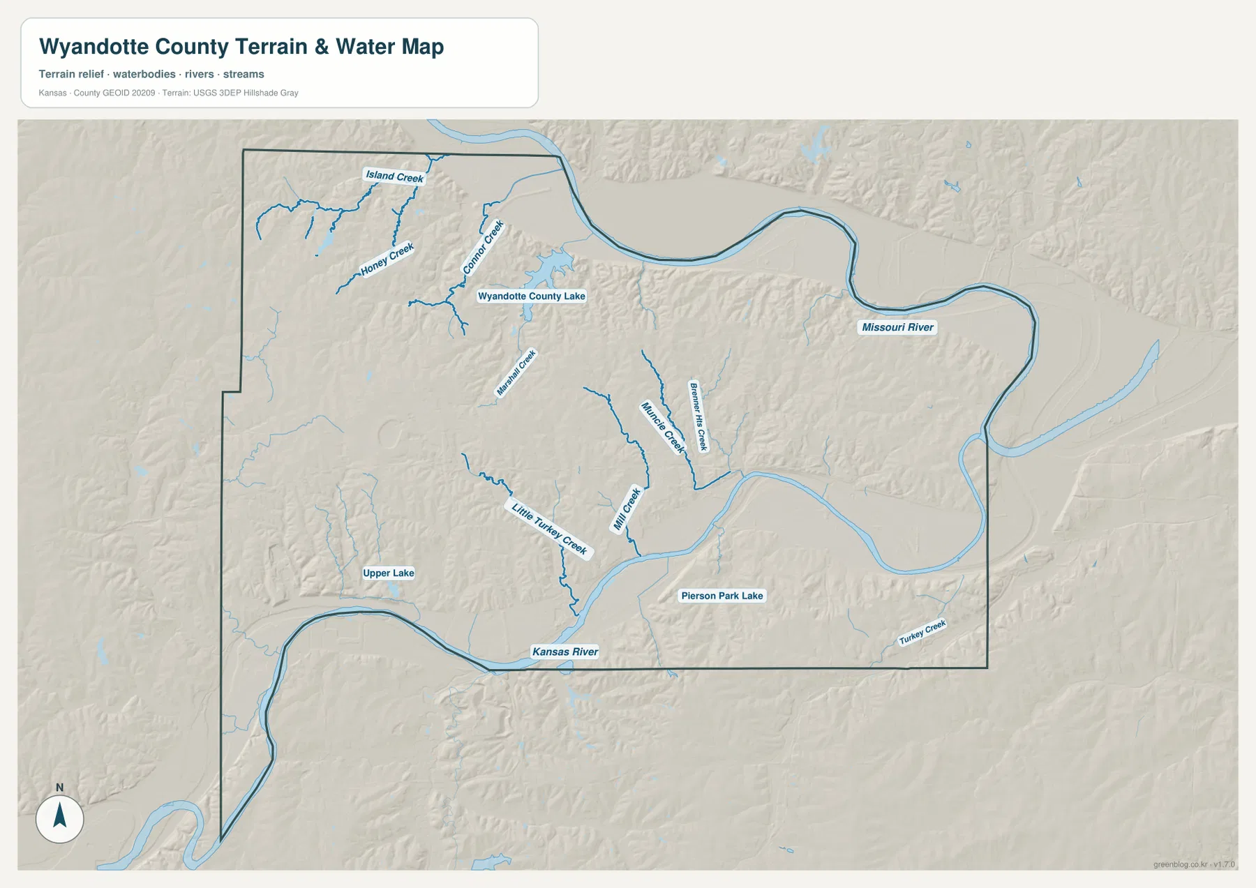
Wyandotte County Lake is the largest interior water body on the map. Unified Government Parks and Recreation material identifies Wyandotte County Lake Park at 91st Street and Leavenworth Road and publishes current fishing and boating rules for the lake. Pierson Park Lake and Upper Lake appear farther south as smaller urban and neighborhood water references.
This image is intended for geographic reference rather than floodplain, navigation, water-quality, parcel, or legal-access decisions. River and lake conditions can change, so current agency information should be used whenever boating, fishing, or shoreline access depends on water level or park rules.
Elevation from 219 to 325 meters separates broad river bottoms from deeply cut interior hills
The elevation surface ranges from about 219 to 325 meters, with a mean near 269 meters. Dark green lowlands follow the Missouri and Kansas rivers, while tan and brown higher ground covers much of the western and central interior. More than 100 meters of relief across such a small county produces a much more rugged landscape than the urban road map alone suggests.
The highest terrain is concentrated mainly in the west and north-central interior, where creeks have carved short, steep valleys into the uplands. Ridges surround Wyandotte County Lake, and the terrain generally falls toward the broad river bottoms along the eastern and southern edges.
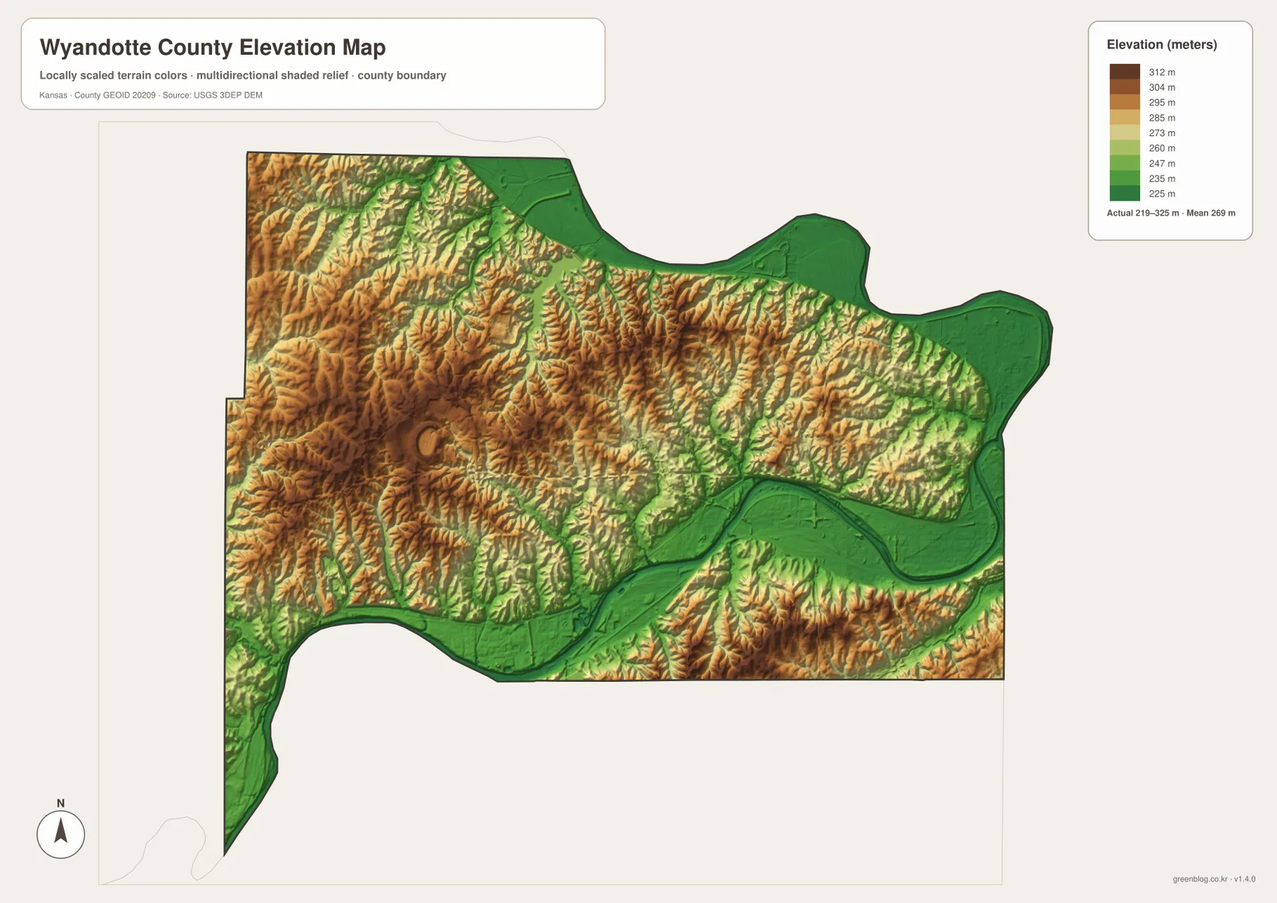
South of central Kansas City, the Kansas River valley creates a wide low corridor beside much steeper slopes. The same pattern appears along the Missouri River, where flat floodplain ground gives way quickly to higher neighborhoods and wooded ravines inland.
The elevation surface is generalized for county-scale comparison. It is not survey-grade or engineering-grade measurement and should not be used for parcel elevations, construction grades, drainage design, or legal boundary work.
Kaw Point combines the river confluence with early exploration history
Kaw Point Park occupies the place where the Kansas River enters the Missouri River. Visit Kansas City Kansas records that the Lewis and Clark Expedition camped there from June 26 through June 28, 1804. The present park includes interpretive features, trails, river views, an amphitheater, and a boat launch.
On the water map, Kaw Point is easy to locate at the far eastern confluence. It is an unusual setting where a major urban and industrial district sits directly beside two large rivers, making the site useful for understanding both the county’s physical geography and its early travel history.
Wyandot settlement and the 1859 constitutional convention connect the county name to Kansas statehood
The Kansas Historical Society explains that Wyandotte County was named for the Wyandot people. Members of the Wyandot Nation moved from Ohio to this area in 1843 and established a community near the river confluence. Huron Indian Cemetery remains one of the most visible traces of that early settlement in present-day Kansas City.
Wyandotte also played a major role in Kansas statehood. In 1859 the Wyandotte Constitutional Convention produced the constitution under which Kansas entered the Union. The modern urban landscape has changed dramatically, but the county name and early Kansas City history remain closely tied to the Wyandot settlement and this constitutional period.
Kansas’s smallest county by land area contains an unusually dense mix of city and natural features
The Kansas Historical Society identifies Wyandotte as the smallest Kansas county by land area, at roughly 151 square miles. Despite that size, it contains the state’s Kansas City urban core, separate western communities, two major rivers, a large county lake, industrial districts, wooded ravines, and extensive transportation infrastructure.
That compact mix is why the county is easier to understand when the road, water, and elevation views are compared together. The low river edges, higher western neighborhoods, lake country, and dense eastern city all change within short distances.
For posters, classroom prints, or presentation slides, use the original JPG files in the download archive rather than enlarging the web previews. Small road labels, creek names, city-connection text, and the elevation legend remain clearer at the higher resolution.
Frequently Asked Questions
Are the 155,135, 7,839, and 4,724 values current populations?
No. Kansas City 155,135, Bonner Springs 7,839, and Edwardsville 4,724 are map index values supplied with this package. They are separate from current official population statistics. The roughly 7-mile and 5-mile labels are straight-line map distances from Kansas City, not driving distances.
Why is Kaw Point important?
Kaw Point is where the Kansas River joins the Missouri River, so it marks the meeting point of the county’s two largest natural boundaries. It is also associated with the Lewis and Clark Expedition’s 1804 camp, giving the site both geographic and historical significance.
Can the 219–325 meter elevation image be used for surveying?
No. It is a generalized county-scale terrain image for comparing low Missouri and Kansas River bottoms with higher western and central ridges. Parcel elevations, engineering grades, drainage design, and legal boundary work require more precise official data and, where needed, professional surveying.
Map File Information
The archive contains the Wyandotte County, Kansas general county map, city-connections map, terrain-and-water map, and elevation map as original high-resolution JPG files.
- Included Files: Use only the versions confirmed in the article and supplied images
- File Type: Use the confirmed download contents
- Intended Use: Printing, education, presentations, and map-based projects
Related Maps
Sources and references
- Kansas Historical Society: Wyandotte County, Kansas — county seat, 2020 census table, name origin, and basic history
- Kansas Historical Society: Kansas Counties — Wyandotte County land area and smallest-county context
- Visit Kansas City Kansas: Kaw Point Park — Kansas–Missouri River confluence and Lewis and Clark history
- Unified Government: Maps and GIS — Wyandotte County mapping and GIS information
- Unified Government Parks & Recreation Guide — Wyandotte County Lake Park fishing and boating information
- USGS 3D Elevation Program — elevation and terrain reference data
Green Map creates custom-edited map images using open geographic data sources such as geoBoundaries, Natural Earth, OpenStreetMap, and government open data. These maps are edited visual materials, not raw data files, and are provided for education, documents, presentations, and graphic reference.