Woodson County lies in southeastern Kansas, where Yates Center serves as the county seat and the main road reference within a landscape of wooded creek valleys, rolling uplands, and small rural communities. US 54 crosses the county through Yates Center, while US 75 runs north–south through the same central area. Toronto and Neosho Falls sit in very different parts of the county, with the Verdigris River and Toronto Reservoir shaping the southwest and a dense creek network spreading across the northeast. High-resolution map files are available for download in the section below.
This guide follows Yates Center, the main highways, the Verdigris River and smaller creeks, and terrain ranging from about 263 to 383 meters. WebP previews are available for quick viewing, and the matching high-resolution JPG files can be downloaded together in one ZIP for printing, classroom work, or offline reference.
Table of Contents
Yates Center anchors the US 54 and US 75 crossroads
Yates Center sits near the middle of Woodson County, where US 54 provides the primary east–west route and US 75 provides the north–south connection. Kansas Department of Transportation project records confirm US 54 across Woodson County from the Greenwood County line through Yates Center to the Allen County line, along with the US 75 corridor from the Wilson County line toward Yates Center.
The Kansas Historical Society identifies Yates Center as the county seat. Neosho Falls served as the original seat from 1858 to 1873, followed briefly by Kalida and Defiance. An election in 1876 placed the county seat at Yates Center, where it remains today.
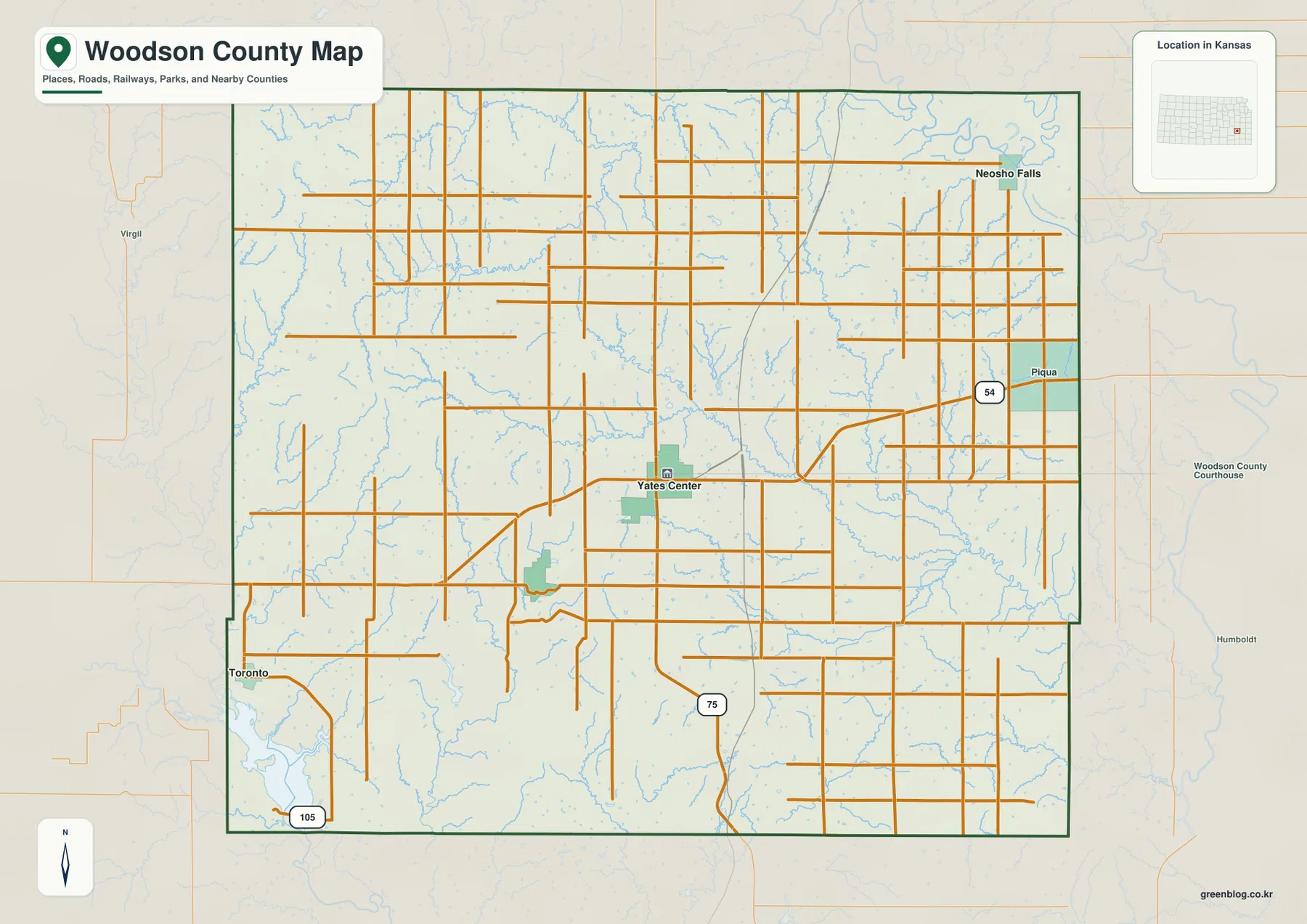
Toronto lies in the southwest and provides the main road reference for K-105, Cross Timbers State Park, and Toronto Reservoir. Neosho Falls occupies the northeastern side, while Piqua is shown along the eastern US 54 corridor. Away from these communities, road grids and creek valleys become more useful for orientation than town markers.
The city-connections panel links Yates Center with Toronto and Neosho Falls
The supplied city-connections panel places Yates Center at an index value of 1,270, Toronto at 260, and Neosho Falls at 132. These are map index values rather than current official population estimates. The panel also labels both Toronto and Neosho Falls at about 13 miles in straight-line distance from Yates Center; those numbers are not driving distances.
The equal distance labels hide very different settings. Toronto lies southwest toward the Verdigris River and reservoir country, while Neosho Falls lies northeast among lower creek valleys. Their relationship to Yates Center becomes much clearer when the road, water, and elevation views are compared.
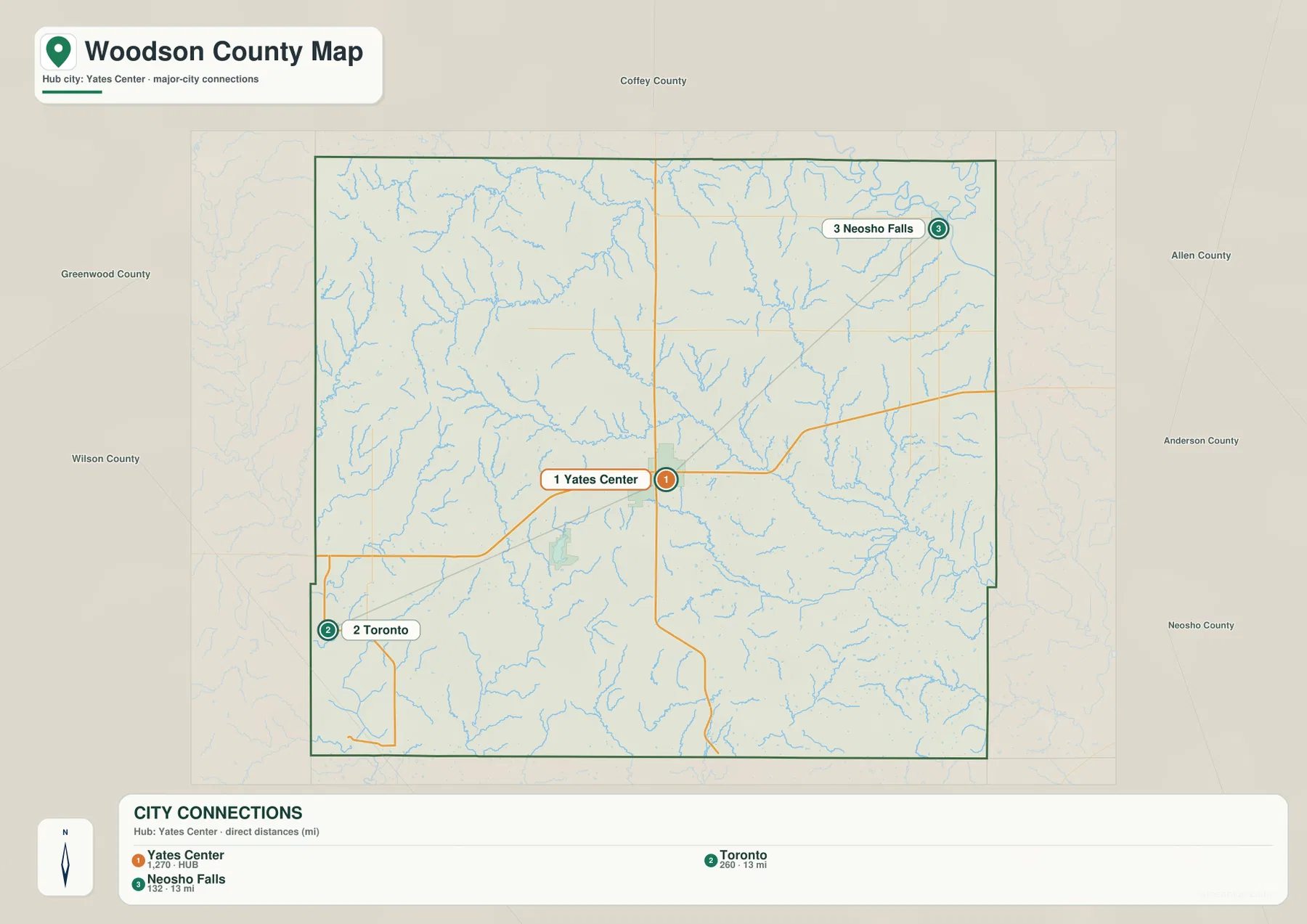
Kansas Historical Society 2020 census material lists Yates Center at 1,352 residents, which illustrates why the supplied 1,270 value should not be treated as a current population count. The panel is best used for relative city context and direct-distance comparison.
Turkey Creek, Owl Creek, and Cherry Creek divide the rolling interior
Turkey Creek is one of the strongest drainage lines in the northwest, collecting short tributaries before continuing toward the county interior. Duck Creek forms a separate northern valley. Across the center, Owl Creek runs eastward through rolling terrain, while Cherry Creek descends from the northeast and joins the broader drainage network.
Rock Creek and Leonards Lake provide eastern references, and Circle Lake appears near the northeastern side. Yates Center City Reservoir sits close to the county seat. South Owl Creek and Sandy Creek create longer low corridors through the southern half.
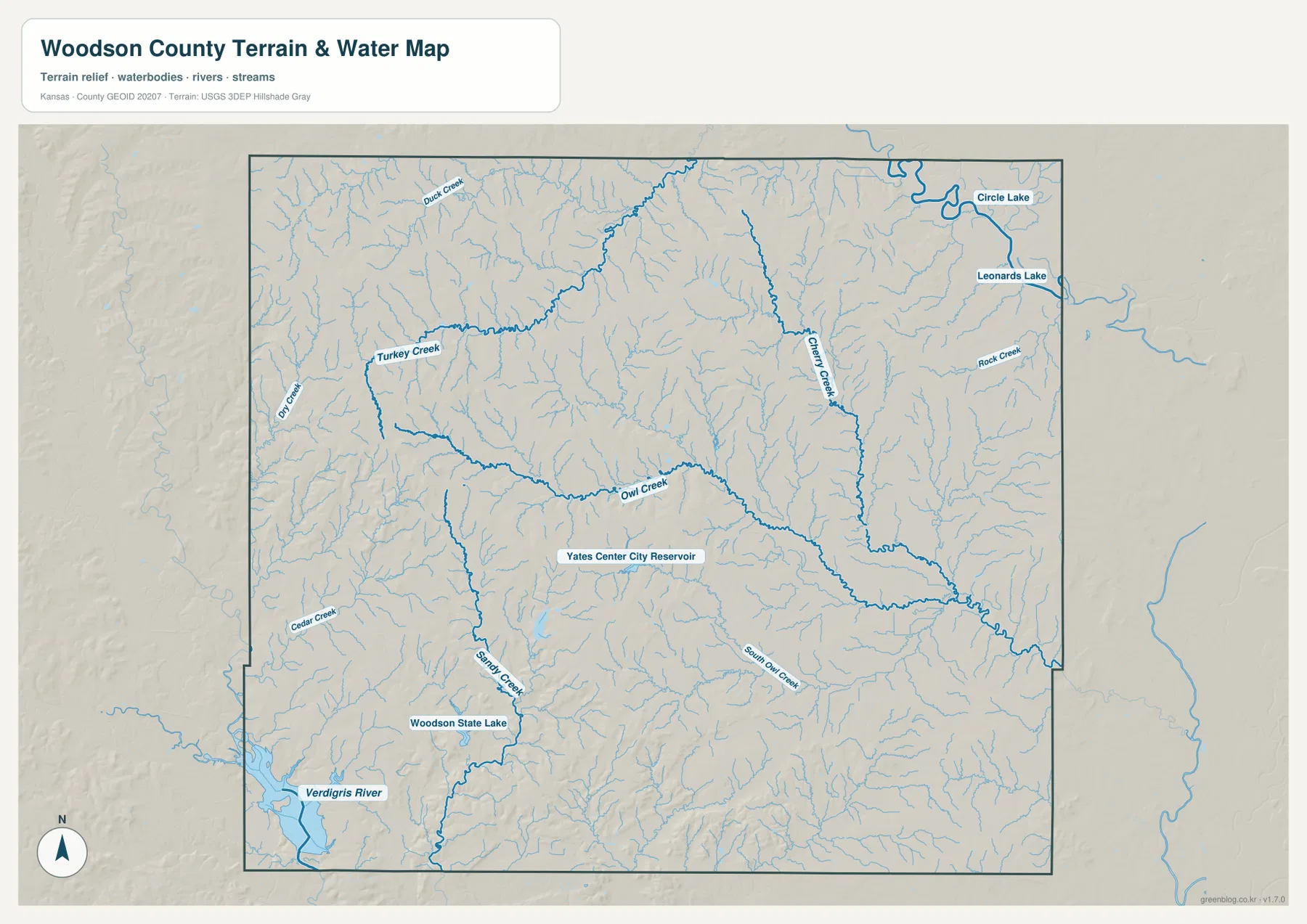
Cedar Creek and Sandy Creek frame the Woodson State Fishing Lake area in the southwest, while the Verdigris River creates the broadest lowland near the county boundary. That river system continues toward Toronto Reservoir and the Cross Timbers landscape west of Yates Center.
This image is intended for geographic reference rather than floodplain, navigation, water-quality, parcel, or legal-access decisions. Stream and lake conditions can change, so current agency information should be used whenever access or safety matters.
Elevation from 263 to 383 meters highlights high western ridges and lower eastern valleys
The elevation surface ranges from about 263 to 383 meters, with a mean near 317 meters. Brown and tan high ground is concentrated across the west and northwest, while greener lower terrain occupies much of the east and northeast. Another broad low area follows the Verdigris River and reservoir country in the southwest.
Turkey Creek and Cedar Creek cut narrow green corridors into the higher western ridges. Around Yates Center, intermediate uplands alternate with creek bottoms, while the eastern side opens into wider connected valleys.
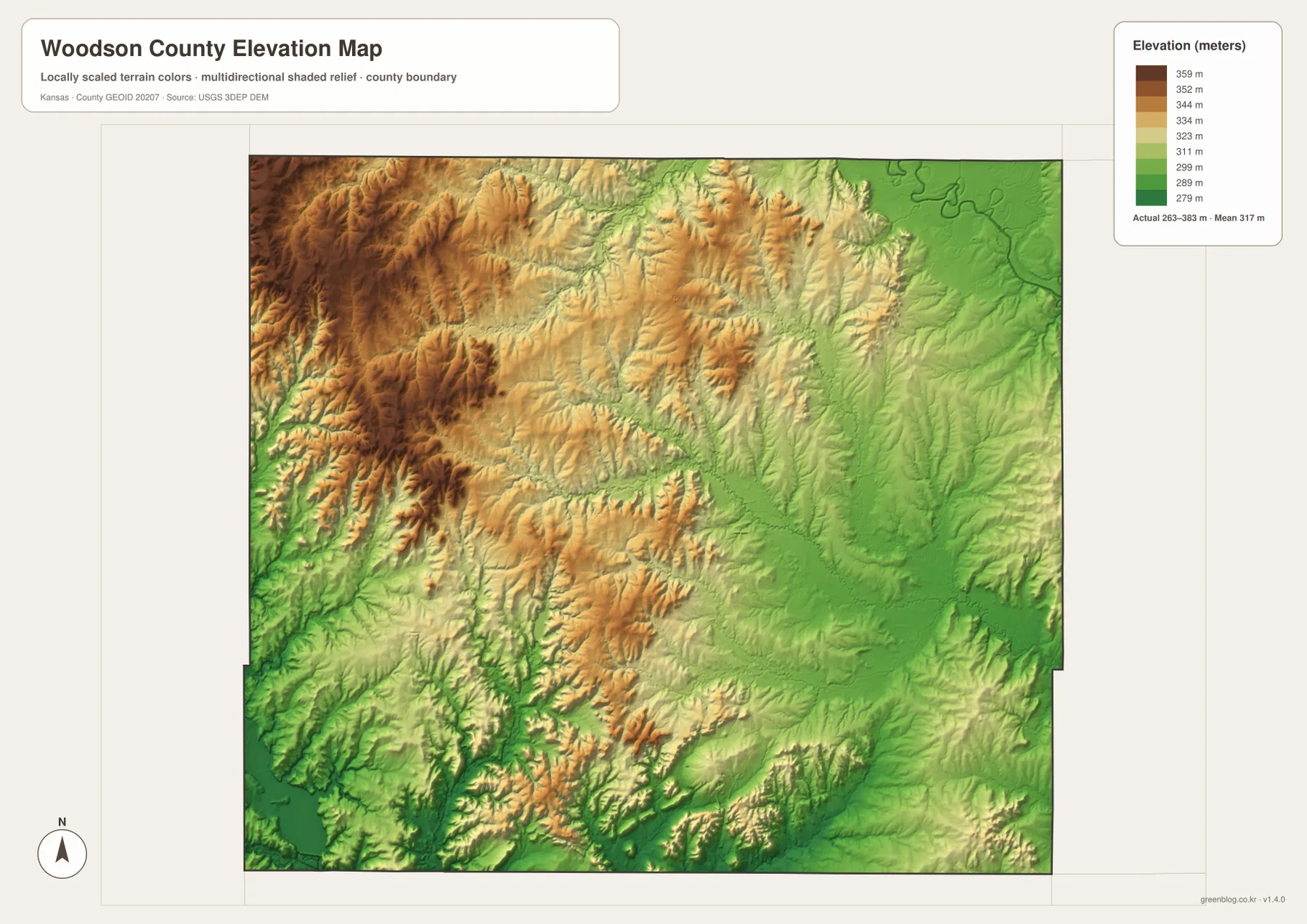
The Kansas Historical Society places Woodson County across the Osage Cuestas and Chautauqua Hills physiographic regions. That combination fits the relief image, where long ridges and stair-step uplands in the west are repeatedly cut by creeks before giving way to lower eastern terrain.
The elevation surface is generalized for county-scale comparison. It is not survey-grade or engineering-grade measurement and should not be used for parcel elevations, construction grades, drainage design, or legal boundary work.
Cross Timbers State Park and Toronto Reservoir define the southwest landscape
Kansas Department of Wildlife and Parks places Cross Timbers State Park about 12 miles west of Yates Center and south of Toronto. The park covers roughly 1,075 acres and provides access to the 2,800-acre Toronto Reservoir. Forested floodplains, prairie terraces, and oak-savanna hills make the area noticeably different from the more open agricultural uplands around central Woodson County.
The Kansas Historical Society notes that Toronto Lake was developed in Woodson and Greenwood counties as part of flood control on the Verdigris River, with construction beginning in 1954 and completion in 1960. The reservoir also supports water supply, water-quality, and recreation functions. Comparing the southwest road and relief maps shows why the reservoir occupies one of the county’s broadest lowland settings.
Woodson State Fishing Lake adds a smaller water landmark east of Toronto
Kansas Department of Wildlife and Parks lists Woodson State Fishing Lake at 180 surface acres and places it about 5.5 miles east of Toronto. It is much smaller than Toronto Reservoir but appears clearly on the county water map near Sandy Creek.
The lake sits among rolling terrain cut by narrow valleys, making it a useful reference for the southwestern interior. Fishing and boating conditions can change with water level and management, so current KDWP information should be checked before a visit.
Yates Center Courthouse Square preserves the county-seat story in the town plan
Kansas Historical Society register material records that Yates Center was platted in 1875 around a courthouse or public square. After the town became the county seat in 1876, commercial buildings developed around that central block. The present Woodson County Courthouse was constructed in 1899.
The Yates Center Courthouse Square Historic District includes a concentration of historic commercial buildings around the square. On the county map, Yates Center appears as a small road hub; on the ground, the courthouse square shows how county government shaped the town’s street layout and commercial center.
Routes from Yates Center lead to two very different landscapes
Heading southwest from Yates Center toward Toronto moves through rolling uplands before descending toward the Verdigris River, Toronto Reservoir, and Cross Timbers State Park. The K-105 corridor provides one of the clearest road references for this transition.
Traveling northeast toward Neosho Falls leads instead into lower terrain broken by Cherry Creek, Rock Creek, and many short tributaries. Although the city-connections panel labels both Toronto and Neosho Falls at about 13 miles straight-line distance from Yates Center, the water and relief maps show that the two directions cross very different landscapes.
For posters, classroom prints, or presentation slides, use the original JPG files in the download archive rather than enlarging the web previews. Small road labels, creek names, town text, and the elevation legend remain clearer at the higher resolution.
Frequently Asked Questions
Are the 1,270, 260, and 132 values current populations?
No. Yates Center 1,270, Toronto 260, and Neosho Falls 132 are map index values supplied with this package. They are separate from current official population statistics. The roughly 13-mile labels are also straight-line map distances from Yates Center, not driving distances.
Are Toronto Reservoir and Woodson State Fishing Lake the same water body?
No. Toronto Reservoir is the large Verdigris River reservoir spanning parts of Woodson and Greenwood counties. Woodson State Fishing Lake is a separate 180-acre public lake about 5.5 miles east of Toronto.
Can the 263–383 meter elevation image be used for surveying?
No. It is a generalized county-scale terrain image for comparing higher western ridges with lower creek and Verdigris River valleys. Parcel elevations, engineering grades, drainage design, and legal boundary work require more precise official data and, where needed, professional surveying.
Map File Information
The archive contains the Woodson County, Kansas general county map, city-connections map, terrain-and-water map, and elevation map as original high-resolution JPG files.
- Included Files: Use only the versions confirmed in the article and supplied images
- File Type: Use the confirmed download contents
- Intended Use: Printing, education, presentations, and map-based projects
Related Maps
Sources and references
- Kansas Historical Society: Woodson County, Kansas — county-seat history, physiographic regions, Toronto Lake, and county background
- Kansas Historical Society: Woodson County Historic Places — Woodson County Courthouse and Yates Center Courthouse Square Historic District
- Kansas Department of Wildlife and Parks: Cross Timbers State Park — Toronto Reservoir access, park size, and landscape information
- Kansas Department of Wildlife and Parks: Woodson State Fishing Lake — lake size and location information
- Kansas Department of Transportation: 2024 Annual Report Appendix — Woodson County US 54 and US 75 corridor information
- USGS 3D Elevation Program — elevation and terrain reference data
Green Map creates custom-edited map images using open geographic data sources such as geoBoundaries, Natural Earth, OpenStreetMap, and government open data. These maps are edited visual materials, not raw data files, and are provided for education, documents, presentations, and graphic reference.