Lewis County is a compact rural county in south-central Tennessee where Hohenwald provides the clearest starting point for reading the map. U.S. 412 crosses the county through Hohenwald, while State Routes 48, 99, and 20 open different approaches to the west, south, and southeast. Beyond the city, the most noticeable pattern is not a chain of large towns but a dense network of creek valleys cut into the Highland Rim uplands.
This page includes a general county map, a city map, a water map, and an elevation map. The WebP images make it easy to compare the layers on screen, and the map file box below provides a ZIP containing four high-resolution A3 JPG files. The maps are most useful when they are treated as related views of the same county: roads explain access, water explains the valley network, and elevation shows why the landscape changes so quickly over short distances.
Table of Contents
Hohenwald is the road reference that organizes the county map
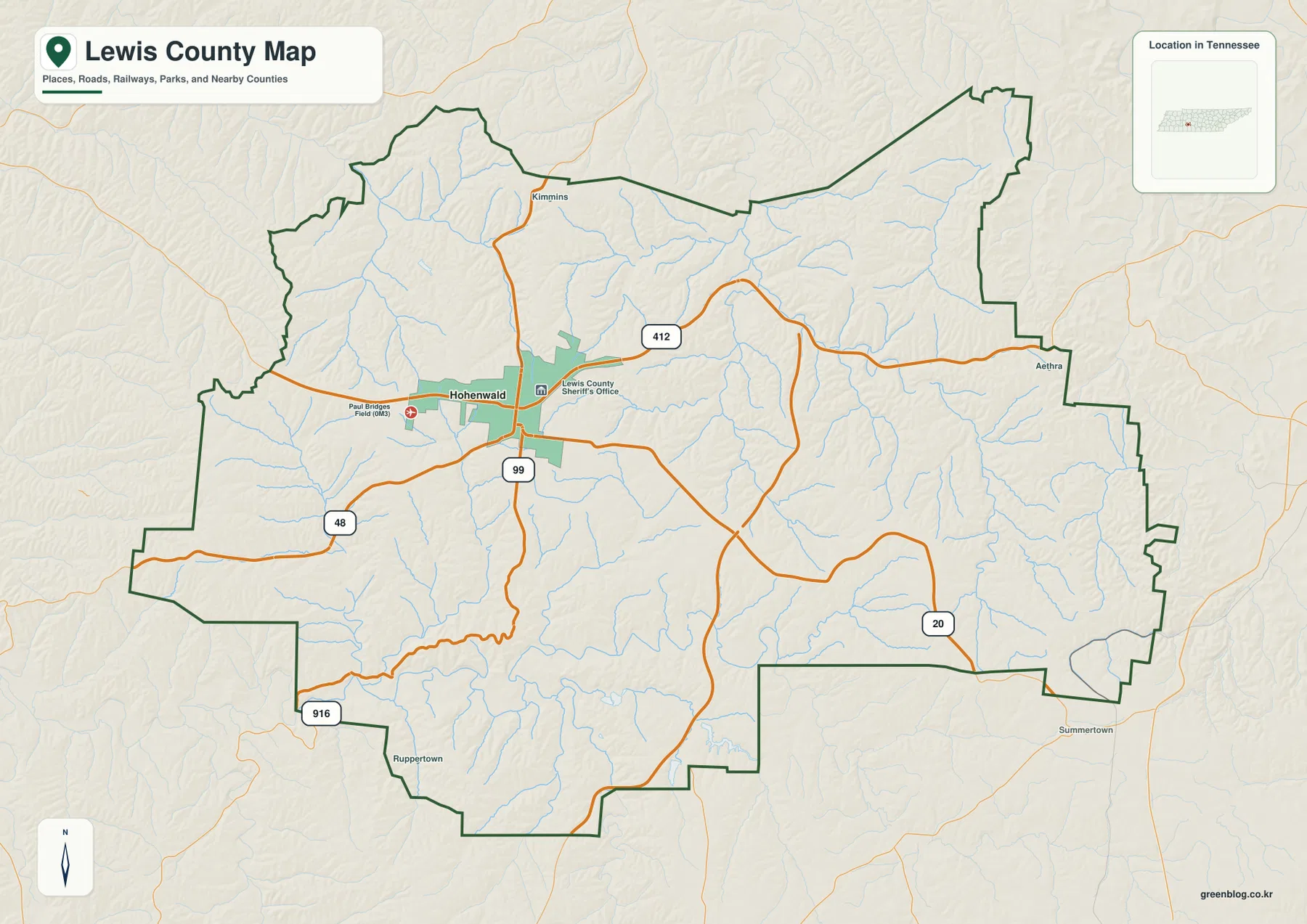
Hohenwald is the Lewis County seat and the main built-up area shown on the supplied county map. The county is bordered by Hickman, Maury, Lawrence, Wayne, and Perry counties, and its outline has several steps and projections rather than a simple rectangular shape. Starting at Hohenwald makes that irregular boundary much easier to follow because the major routes can be traced outward before the smaller edge labels are considered.
U.S. 412 forms the strongest east-west route on the image. State Route 48 approaches Hohenwald from the west, SR 99 leaves the city toward the south, and SR 20 appears across the southeastern side of the county. The map also labels places near the edges, including Kimmins to the north and Aethra to the east, while Summertown appears outside the southeastern boundary. Those labels are useful orientation points, but Hohenwald remains the place where the principal road pattern is easiest to understand.
The 2020 census counted 12,582 residents in Lewis County, and the Census Bureau’s July 2025 estimate is 13,487. The package’s Gazetteer summary lists about 282.1 square miles of land and 0.4 square miles of water. Those countywide totals provide scale, but the map tells a more useful settlement story: a recognizable city center at Hohenwald is surrounded by a much larger rural area where roads and streams, rather than additional large cities, provide most of the local reference points.
The city map is unusual because it ranks only one major city
The city map differs sharply from county pages that contain several ranked municipalities. Here, the city index contains only Hohenwald. That makes the image simple, but the simplicity is informative: it shows that the county’s main urban reference is concentrated in one place rather than divided among several similarly prominent towns. Smaller names on the general map should therefore not be assumed to represent cities of the same category.
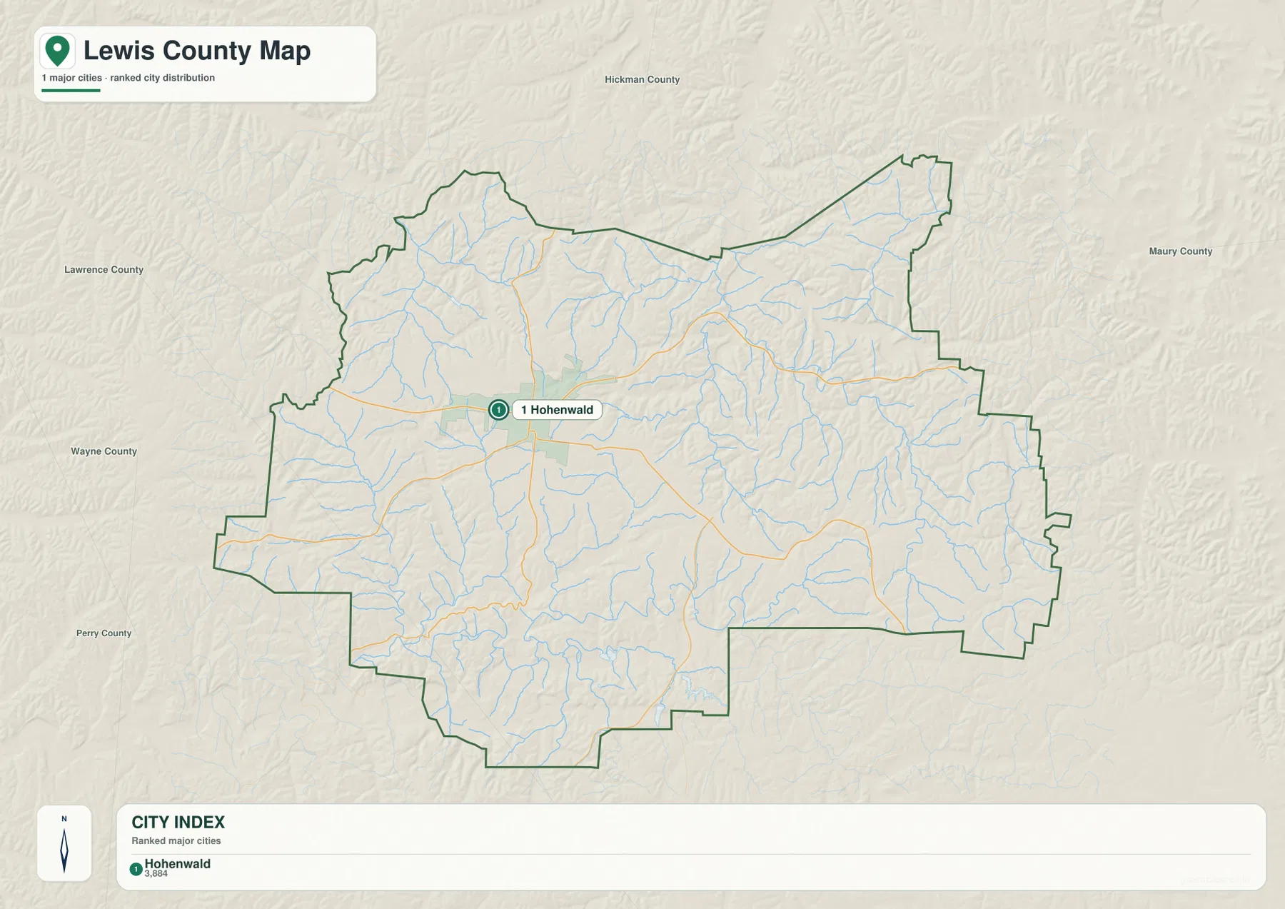
This view works especially well for presentations or worksheets that need one clear city anchor. Hohenwald sits slightly west of the center of the county outline, close to the U.S. 412 corridor and the junctions of the routes that lead south and west. The surrounding relief remains visible in the background, so the city does not appear as an isolated dot on a blank county shape; it is visibly embedded in a landscape of narrow drainage lines and ridges.
When more detail is needed, switch back to the general map. It adds the route shields, edge communities, small waterways, the county sheriff’s office, and the local airfield near Hohenwald. Using the two maps together prevents a common reading mistake: the city map answers where the principal city is, while the county map answers how that city connects to the rest of Lewis County.
Buffalo River and the Swan Creek network reveal two sides of the drainage pattern
The water map gives Lewis County a very different appearance. Buffalo River is the boldest river in the southern part of the image, and a USGS monitoring location named Buffalo River Near Hohenwald is in Lewis County. Tennessee’s scenic-river program also identifies Lewis County as one of the counties crossed by the Buffalo River. On the supplied map, Rockhouse Creek and other southern tributaries lead toward that larger channel, making the southern valley system easy to distinguish.
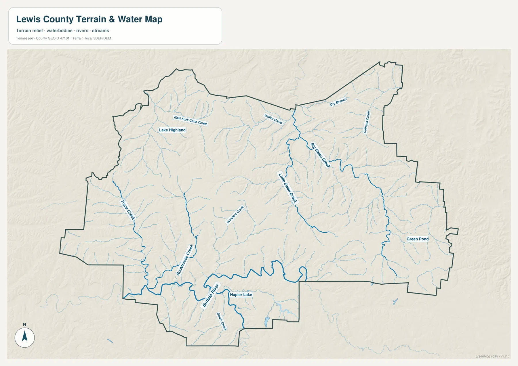
Farther north and east, Big Swan Creek and Little Swan Creek create another prominent set of valleys. Indian Creek, Dry Branch, Cane Creek, and smaller branches feed the network, while Trace Creek and East Fork Cane Creek appear on the western side. The important point is not to memorize every tributary. The map is clearer when the larger branches are used first, then the smaller blue lines are followed into the surrounding ridges.
Lake Highland, Napier Lake, and Green Pond add several small water landmarks. Napier Lake sits near the southern Buffalo River corridor, while Lake Highland helps identify the northwestern part of the county. These are small features compared with the full drainage network, yet they are useful when matching the water layer to the general road map because they provide fixed names in areas where settlement labels are sparse.
The elevation map shows an upland cut by many narrow valleys
The elevation legend on the supplied map gives an actual range of roughly 172 to 325 meters, with a mean near 260 meters. The high ground is not confined to one corner. Broad brown and tan uplands occur across the central, southern, and eastern parts of the county, while green low areas form branching corridors along streams. This pattern fits the Western Highland Rim setting described by Tennessee’s Lewis State Forest information: the county is upland country, but streams have carved deeply into that surface.
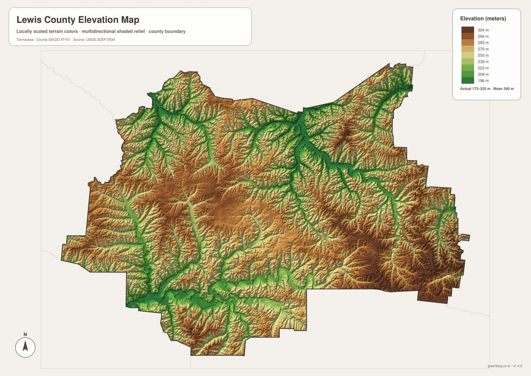
The relationship with the water map is particularly clear around Buffalo River. The river follows a broader low corridor in the south, with Rockhouse Creek and smaller branches cutting into higher ground. In the northeast, the Big Swan and Little Swan Creek systems form another maze of lower valleys. Between those drainages, higher ridges remain as tan and brown areas, so the county looks much more dissected on the elevation map than it does on a simple boundary map.
The colors are elevations, not land-cover or ownership classes. A brown ridge can contain forest, homes, or roads, and a green valley is not automatically wetland. The map is intended to show relative height and landform shape at county scale. Parcel elevations, engineering grades, trail conditions, and flood risk require more detailed sources than this generalized relief image.
Natchez Trace and Lewis State Forest provide two distinct local landmarks
Natchez Trace Parkway is one of the best-known geographic references associated with Lewis County. The National Park Service places the Meriwether Lewis Death and Burial Site at milepost 385.9 in Lewis County near Hohenwald. NPS travel information also lists a Hohenwald access point at U.S. 412 around milepost 391.1. Those references place the Parkway east of Hohenwald and help connect the county’s modern highway map with one of its major historic travel corridors.
Lewis State Forest supplies a different type of landmark west and southwest of Hohenwald. The Tennessee Division of Forestry describes it as a 1,288-acre state forest on the Western Highland Rim and notes that Highway 48 bisects the property. That makes SR 48 more than a road shield on the county map: as it leaves Hohenwald, it also leads through a managed forest landscape characteristic of this part of Tennessee.
Neither feature should be treated as if the county map were a detailed visitor map. The Parkway has its own access points, mileposts, historic sites, and current operating information, while Lewis State Forest has separate roads and trail-use rules. For county-level orientation, however, the two features are valuable because they place Hohenwald between a nationally recognized north-south parkway corridor and a large block of managed Highland Rim forest.
Follow one place through the road, water, and relief views
A practical way to use the set is to keep Hohenwald fixed and change the layer. On the county map, the city is where U.S. 412 and several state routes come together. On the city map, nearly all secondary labels disappear and Hohenwald becomes the sole ranked city. The water map shifts attention away from the street network toward Buffalo River, Swan Creek, and the many tributaries, while the elevation map explains why those streams form such narrow, branching corridors.
The same method works along the southern side of the county. Find Buffalo River and Rockhouse Creek on the water map, then move to the elevation image and look for the wider green valley following the river. In the northeast, Big Swan Creek and Little Swan Creek line up with a different set of low green branches carved into higher ground. Comparing those areas makes the county’s terrain easier to describe than simply listing elevations or stream names.
For printing, choose the file that matches the task. The general county map is best when roads and boundaries matter; the city map is the cleanest choice for showing Hohenwald’s position; the water map is designed for named rivers, creeks, and small lakes; and the elevation map works when a lesson or report needs to explain ridges and valleys. Printing two maps side by side is often the clearest way to connect a road route with the terrain or drainage it crosses.
Frequently Asked Questions
Why does the city map show only Hohenwald as a ranked major city?
The supplied city index contains one ranked major city for Lewis County, and that city is Hohenwald. Smaller place names appear on the general county map, but they are not presented in the same city-ranking category. Use the city map for a clean county-seat reference and the general map when you need the smaller labels and road network.
Which maps should I compare to understand the Buffalo River valley?
Start with the water map to locate Buffalo River and Rockhouse Creek in the southern part of the county, then compare the same area on the elevation map. A broader low corridor follows the river while higher ridges rise around many of the tributaries, making the valley pattern much easier to see.
What is included in the Lewis County map download?
The archive contains four high-resolution A3 JPG files: the general county map, city map, water map, and elevation map. The WebP images in the article are convenient screen previews; the JPG files are the better option for printing or use in a larger document.
Map File Information
The ZIP contains the Lewis County general map, city map, water map, and elevation map as high-resolution A3 JPG files. Use the larger originals when you need a print copy or want to place the maps into another document.
- Included Files: Four high-resolution A3 JPG maps
Related Maps
- Alamo to Gadsden: A Crockett County Tennessee Map
- Altamont, Monteagle, and Plateau Valleys — Grundy County Tennessee Map
- Around Chattanooga: Hamilton County Tennessee Map
Sources and references
- U.S. Census Bureau QuickFacts – Lewis County, Tennessee
- National Park Service – Natchez Trace Parkway maps
- National Park Service – Meriwether Lewis Death and Burial Site
- Tennessee Department of Environment and Conservation – Buffalo River
- Tennessee Division of Forestry – Lewis State Forest
- USGS 3D Elevation Program
Green Map creates custom-edited map images using open geographic data sources such as geoBoundaries, Natural Earth, OpenStreetMap, and government open data. These maps are edited visual materials, not raw data files, and are provided for education, documents, presentations, and graphic reference.