Ford County lies in southwestern Kansas, where Dodge City provides the clearest starting point for understanding settlements, highways, the Arkansas River valley, and the High Plains surface. Dodge City is the county seat and the dominant urban center. U.S. 50 and U.S. 56 provide major east-west references, while U.S. 283 extends south from the city. Spearville lies to the northeast, and the communities of Ford and Bucklin sit farther southeast. High-resolution JPG versions of the map set can be downloaded together from the ZIP box later on this page. High-resolution map files are available for download in the section below.
The Arkansas River is the county’s strongest natural landmark. It enters from the west, passes south of Dodge City and Fort Dodge, then bends eastward through a broad low corridor. North of the river, Saw Log Creek, Duck Creek, Coon Creek, and several smaller tributaries cut into the uplands. Mulberry Creek crosses the southern half. The elevation surface ranges from roughly 684 to 839 meters with a mean near 760 meters, showing a clear decline from higher western terrain toward lower eastern country.
The Kansas Historical Society places Ford County in both the High Plains and Arkansas River Lowlands and identifies Dodge City as the county seat. Its history is closely associated with the Santa Fe Trail, Fort Dodge, the railroad, and the cattle trade. Those themes are visible in the modern map: Dodge City and Fort Dodge occupy the main river corridor, and the principal transportation routes follow the same broad east-west setting that has long shaped movement through the county.
Table of Contents
Dodge City at the junction of U.S. 50, U.S. 56, and U.S. 283
The general map makes Dodge City the obvious orientation point. U.S. 50 approaches the city and continues toward Spearville, U.S. 56 enters from the southwest, and U.S. 283 runs south through the county. The Ford County Sheriff’s Office is labeled east of the central city area, and Fort Dodge and Wilroads Gardens provide nearby landmarks along the Arkansas River corridor.
From Dodge City, U.S. 50 gives a straightforward northeast reference toward Spearville. U.S. 400 provides a southeastern route toward the community of Ford and continues toward Bucklin, while K-117 connects the eastern side of the Dodge City area with roads farther north. Other state routes cross the southern county, but the three U.S. highways and Dodge City itself are enough to establish the basic geographic framework.
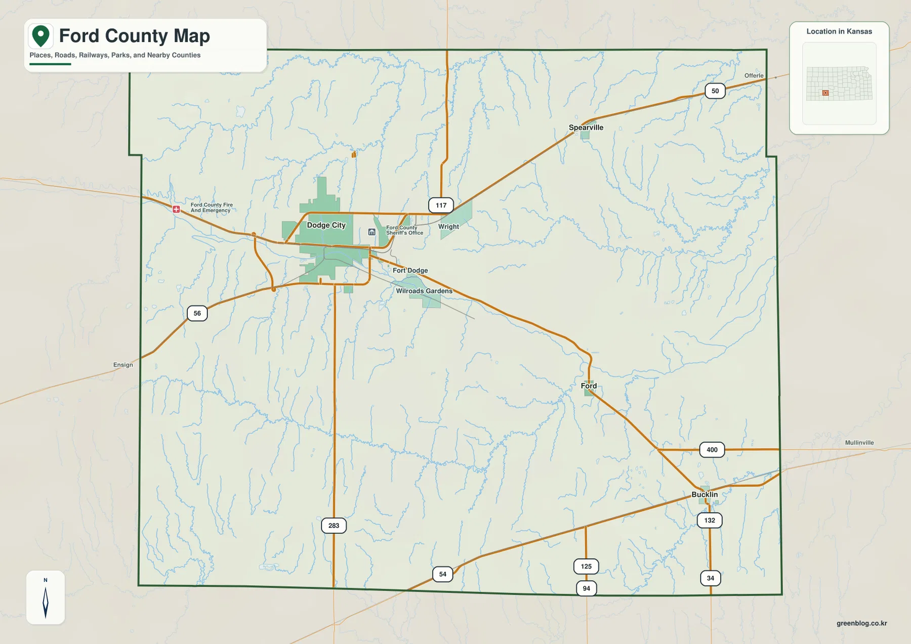
Large rural spaces dominate outside Dodge City. The western and southwestern portions have relatively few settlement labels, while the east and northeast combine small communities with a dense network of creeks. The map is intended for county-scale orientation rather than live navigation, so current road closures, construction, high-wind conditions, and winter travel information should be checked through current transportation sources.
Spearville, Ford, and Bucklin around the Dodge City hub
The city connection map reduces the county to four useful settlement anchors. Dodge City is marked as the hub, with Spearville about 16 miles away in a straight line, Ford about 17 miles away, and Bucklin about 26 miles away. These figures communicate scale and direction rather than driving mileage, but they make the county’s main settlement pattern easy to understand.
Spearville lies northeast of Dodge City and aligns naturally with the U.S. 50 corridor. Ford sits southeast along the U.S. 400 route, while Bucklin lies farther southeast near the county’s lower-right corner. The three smaller communities therefore spread outward from Dodge City rather than forming one continuous urban strip.
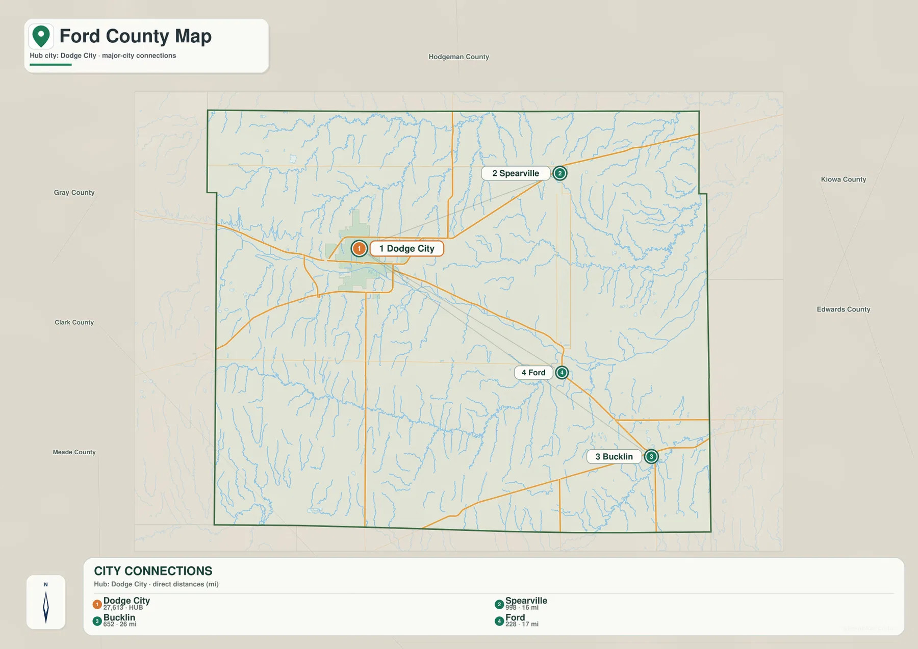
The Kansas Historical Society identifies Dodge City as the county seat and describes its rapid growth around the railroad and cattle trade. That historic prominence is reflected in the modern city map, where Dodge City is far larger than the other labeled communities. Spearville, Ford, and Bucklin remain important geographic reference points because they divide the broad eastern rural area into recognizable destinations.
The Arkansas River corridor and the tributaries of the High Plains
The terrain and water map is dominated by the Arkansas River, which crosses the central part of Ford County from west to east. The river occupies a broad low corridor beneath Dodge City and Fort Dodge. From the higher country on both sides, many smaller streams descend toward this valley or toward neighboring drainage systems.
Saw Log Creek is a prominent northern drainage, joined by a dense network of smaller channels. Duck Creek and a labeled South Fork cut through the northwest and north-central uplands, while Elm Creek passes near Hains Lake. Farther east, White Woman Creek, Little Coon Creek, Coon Creek, and Cow Creek create branching valleys across the lower northeastern terrain.
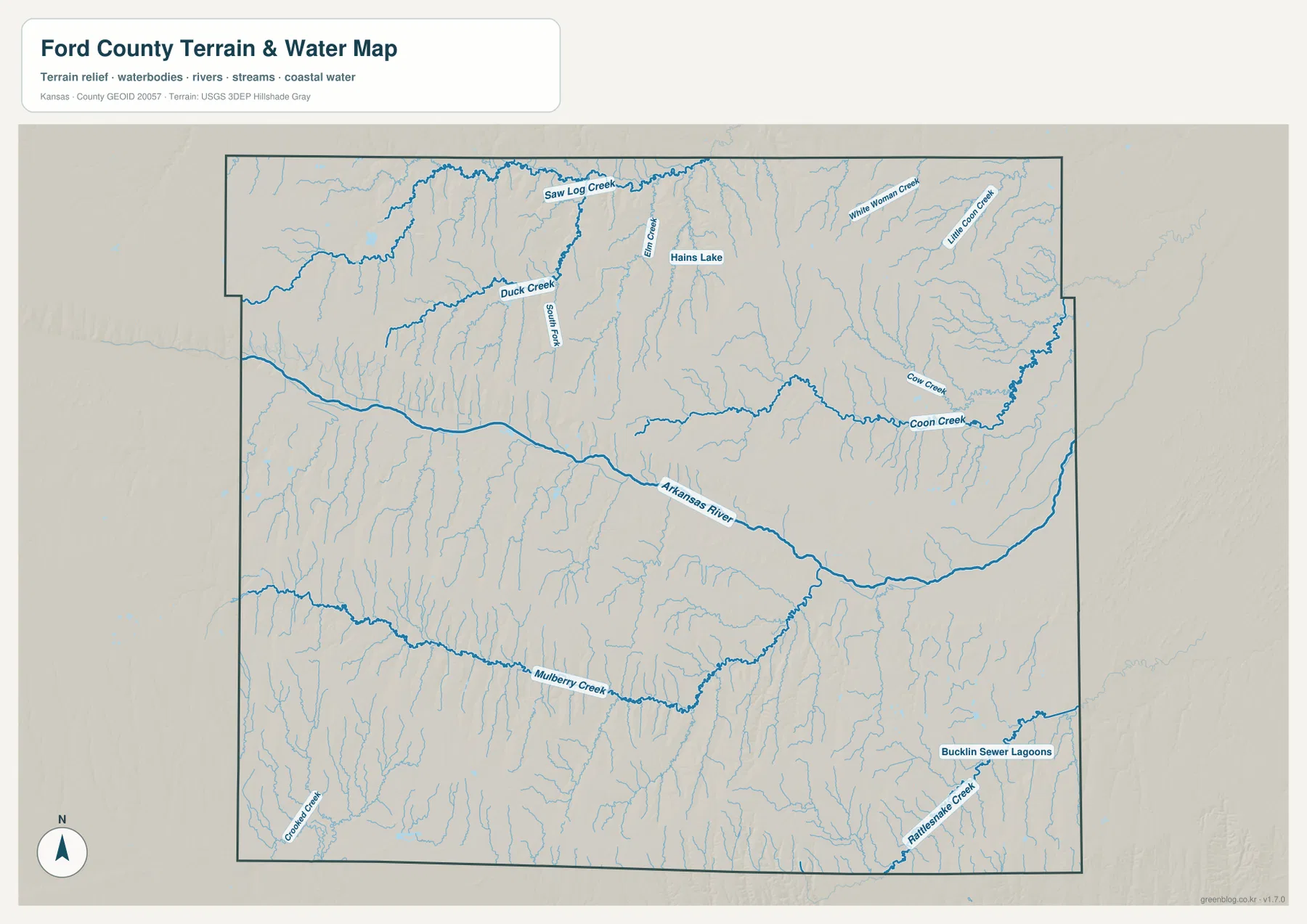
South of the Arkansas River, Mulberry Creek forms a long west-to-east drainage across the middle of the southern half. Crooked Creek appears in the southwest and Rattlesnake Creek in the southeast. These channels demonstrate that the High Plains surface is not uniformly flat; even broad agricultural country contains repeated shallow valleys and drainage divides. The map is not a live source for flood warnings, streamflow, or water quality, so current conditions require USGS or local-agency information.
From 839-meter western uplands to 684-meter eastern lowlands
The elevation map shows an actual range of approximately 684 to 839 meters and a mean elevation near 760 meters. Brown and orange tones dominate the west and southwest, indicating the county’s highest broad surfaces. Dodge City sits at intermediate elevations, and the colors become progressively greener toward the east, where lower terrain occupies a larger share of the county.
The Arkansas River forms a long low band through the middle of this gradient. Tributaries from the north and south create narrow green corridors that cut into the higher surfaces, making the transition much more textured than a simple west-to-east slope. The Coon Creek system is especially visible in the northeast, and the southeastern Arkansas River and Rattlesnake Creek country also lies well below the western uplands.
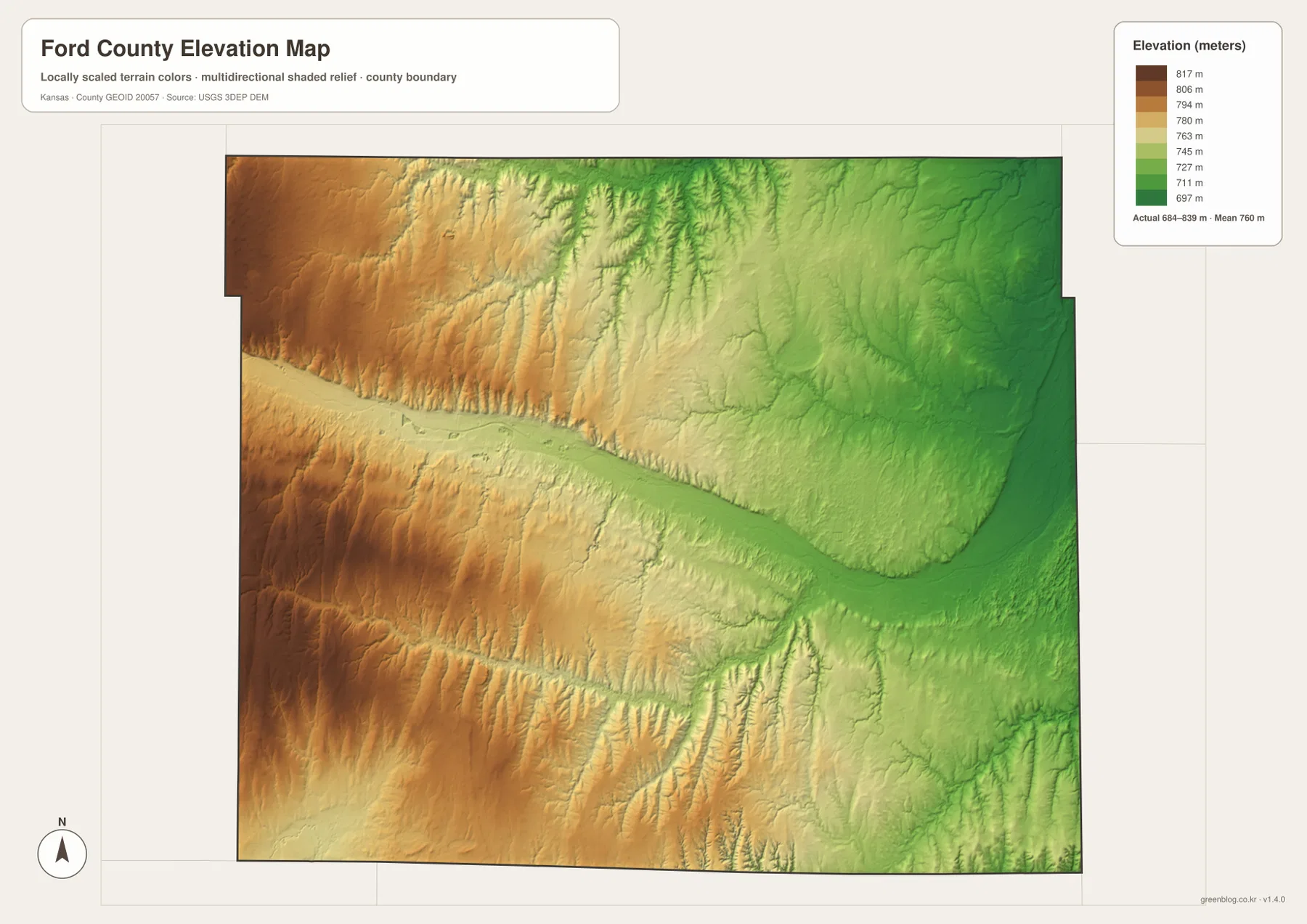
This elevation surface is intended for county-scale comparison rather than survey-grade measurement. It should not be used to establish exact parcel elevations, design drainage, or replace engineering and legal survey data. Its value is visual context: Dodge City can be placed between the higher western plains and the lower eastern terrain, while the Arkansas River clearly follows one of the county’s principal low routes.
High Plains, Arkansas River Lowlands, and the Dodge City story
The Kansas Historical Society describes Ford County as spanning the High Plains and Arkansas River Lowlands. The distinction is easy to see on the map set. Broad higher surfaces dominate much of the west, while the Arkansas River creates a flatter, lower corridor across the middle. Smaller tributaries cut into both settings and give the county more relief than the phrase “flat western Kansas” might suggest.
Fort Dodge was established in 1865 to protect traffic and mail along the Santa Fe Trail, and Dodge City developed nearby after the Santa Fe railroad arrived in 1872. The city soon became one of the best-known cattle towns in the country. The modern map still places Dodge City, Fort Dodge, major highways, and the river close together, showing how transportation and lowland geography have remained linked across different periods of the county’s history.
The famous Dodge City story represents only one part of Ford County. The Spearville area in the northeast, Ford and Bucklin in the southeast, the Mulberry Creek country in the south, and the high western plains all contribute to the county’s present landscape. Combining the settlement, water, and elevation views keeps the county from being reduced to a single historic city.
Choosing the map for orientation, terrain, or printing
For basic orientation, start with Dodge City and the U.S. 50, U.S. 56, and U.S. 283 corridors. The city connection map is useful when the goal is simply to compare Spearville, Ford, and Bucklin with Dodge City. For physical geography, follow the Arkansas River first, then use the terrain and elevation maps to compare Saw Log Creek, Coon Creek, Mulberry Creek, and the higher western plains.
The high-resolution JPG files in the ZIP are better suited than the reduced web previews for printing, classroom work, local-history materials, and close inspection of labels. They are useful for county overviews and regional comparisons, but current roads, live stream conditions, parcel boundaries, and exact elevations should always be checked against the latest authoritative sources when those details matter.
Frequently Asked Questions
Where are Spearville, Ford, and Bucklin relative to Dodge City?
The city connection map places Spearville about 16 miles from Dodge City in a straight line, Ford about 17 miles away, and Bucklin about 26 miles away. Spearville is northeast of Dodge City, while Ford and Bucklin lie farther southeast. Driving distances vary by route.
Why is the Arkansas River important on the Ford County map?
The Arkansas River forms the county’s largest continuous low corridor and passes immediately south of Dodge City and Fort Dodge. Many tributaries descend toward the river or neighboring drainage systems, and the elevation map shows the river valley as distinctly lower than the western High Plains.
Can the 684–839 meter elevation map be used for surveying?
No. The elevation map is a county-scale visual reference for comparing uplands and valleys. Exact parcel elevations, construction design, drainage engineering, and legal surveys require purpose-built data and professional methods appropriate to those tasks.
Map File Information
Download the high-resolution JPG files corresponding to the Ford County general, city connection, terrain-and-water, and elevation maps in one ZIP archive.
- Included Files: Use only the versions confirmed in the article and supplied images
- File Type: Use the confirmed download contents
- Intended Use: Printing, education, presentations, and map-based projects
Related Maps
Sources and references
- Ford County, Kansas official website — county government and local information
- Kansas Historical Society — Ford County, Kansas — Dodge City, Fort Dodge, cattle trade, High Plains, and Arkansas River Lowlands context
- U.S. Census Bureau TIGER/Line — boundary, road, and geographic data resources
- USGS National Hydrography — hydrography and stream-network data information
- USGS 3D Elevation Program — elevation data information
Green Map creates custom-edited map images using open geographic data sources such as geoBoundaries, Natural Earth, OpenStreetMap, and government open data.
These maps are edited visual materials, not raw data files, and are provided for education, documents, presentations, and graphic reference.