Download the high-resolution A3 JPG ZIP for the Hardeman County Tennessee Map directly from this page; it includes the county, city, water, and elevation maps shown below. Bolivar is the largest ranked city and the central map reference, Whiteville lies to the west, Toone is north of Bolivar, and Middleton, Saulsbury, and Grand Junction occupy the southern half. Hatchie River winds through the center and north, while higher rolling ground becomes more prominent toward the southwest and south.
Hardeman County is easier to understand when the towns are connected to the river lowlands and the surrounding uplands. The Hatchie corridor creates broad lower terrain through the middle of the county, while many smaller creeks cut into the rolling ground on both sides. Roads follow those lower passages or cross the uplands between them, so the base map, water map, and elevation layer explain one another rather than acting as separate illustrations.
Table of Contents
Bolivar and Whiteville lead the city map, with southern towns spread along the county edge
The city map ranks Bolivar at 5,144 residents and Whiteville at 4,530. Middleton is third at 743, followed by Grand Junction at 435, Saulsbury at 304, and Toone at 289. The size difference is clear, but location matters just as much: Bolivar sits near the center, Whiteville is farther west, Toone lies to the north, and the other three ranked places form a southern group.
Grand Junction sits close to the southwestern corner, Saulsbury is east of it, and Middleton is farther east near the southern boundary. The base map also labels Pocahontas on the southeastern edge. Together, these southern references show how far the county extends below Bolivar and how the main settlements are distributed along several road corridors rather than concentrated in one compact urban area.
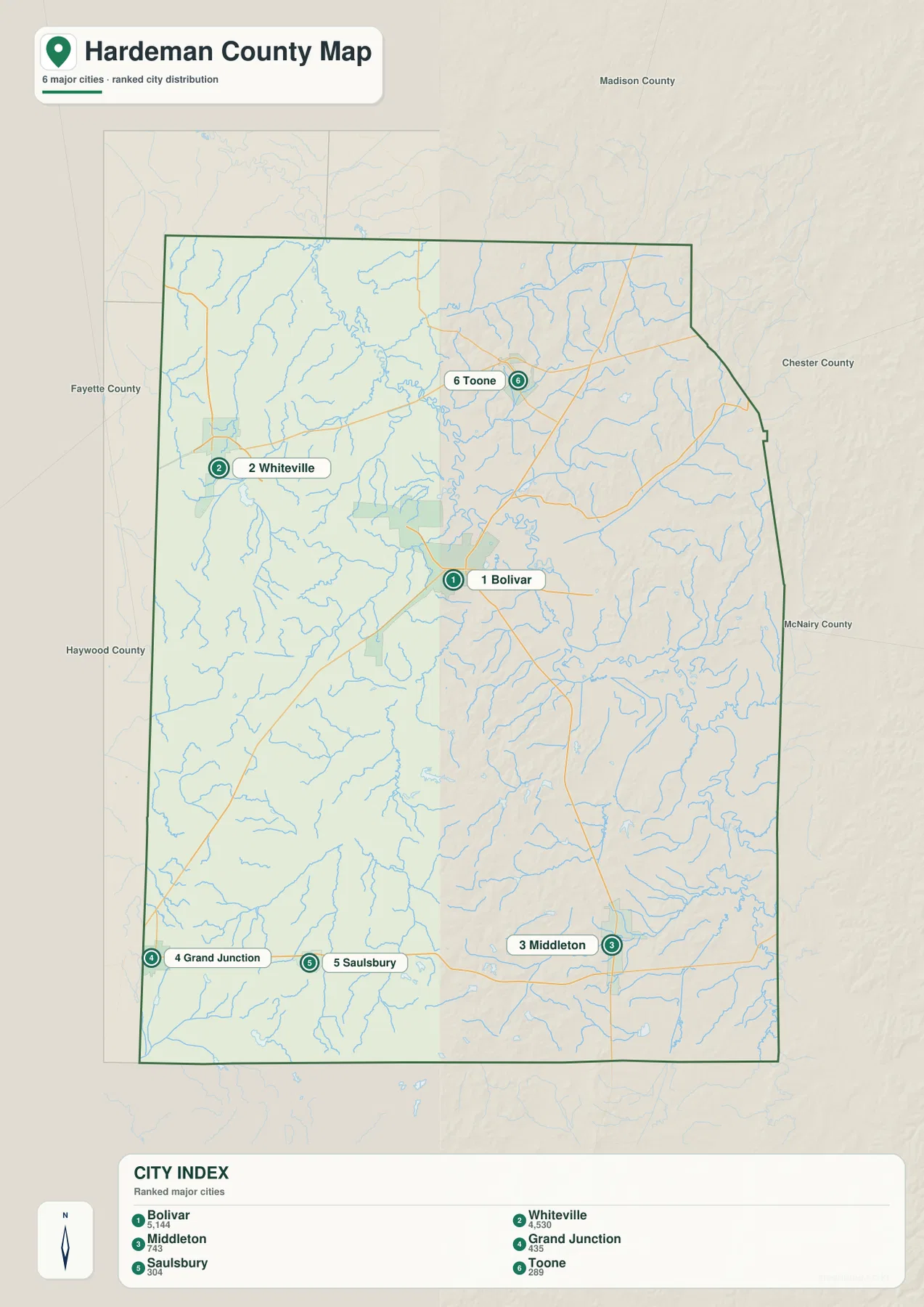
Fayette and Haywood counties appear to the west, Madison County to the north, and Chester and McNairy counties to the east. Those neighboring labels provide useful orientation around the irregular county outline. Whiteville is close to the western side, Toone is nearer the northern side, and Middleton sits much closer to the southeastern county line than Bolivar.
Roads spread from Bolivar toward Whiteville, Toone, and the southern towns
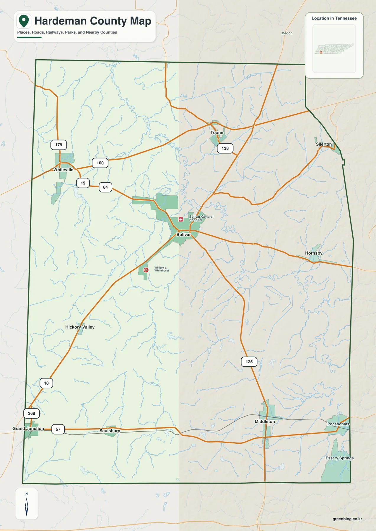
The base map shows Routes 15, 64, and 100 around the Whiteville side. Route 138 appears near Toone in the north, while Route 125 runs south from the Bolivar area toward Middleton. In the southwest, Routes 18 and 368 provide references toward Grand Junction, and Route 57 follows the southern corridor through the Grand Junction–Saulsbury–Middleton side.
Route 179 appears north of Whiteville. These numbered roads are more useful when grouped by destination than when memorized as a list. From Bolivar, the map separates naturally into a western Whiteville direction, a northern Toone direction, and southern routes toward Middleton and the Grand Junction–Saulsbury side.
The base map also labels Hickory Valley, Hornsby, and Silerton. Hickory Valley is a useful southwestern reference near Route 18, Hornsby helps locate the southeastern interior east of Bolivar, and Silerton marks the northeastern edge. The roads bend and spread differently in each area because small creek valleys and rolling uplands repeatedly interrupt a simple straight-line network.
Hatchie River forms the main lowland, while creeks divide the surrounding uplands
Hatchie River is the dominant named water line on the supplied water map. It enters from the north and bends through the central county. Duncan Lake sits near the river in the north, and Clover Creek stretches across the northeastern side. The broad lowland around these waters is also one of the clearest green areas on the elevation map.
Clara Creek occupies a long western valley, while Spring Creek runs through the central-southern area toward the Hatchie corridor. West Fork Spring Creek forms another lower passage in the southwest, with Dry Branch nearby. These streams help explain why some road corridors use long curving valleys instead of crossing the rolling terrain directly.
Cypress Creek is prominent in the southeast. Horseshoe Pond and The Grinnel Pond appear near the central Hatchie corridor, while Lake Lajoie is farther northeast. Lake Hardeman sits in the southern interior, and Frese Pond and Muddy Creek Watershed Lake provide additional southern references. The county therefore contains many smaller water features in addition to its main river.
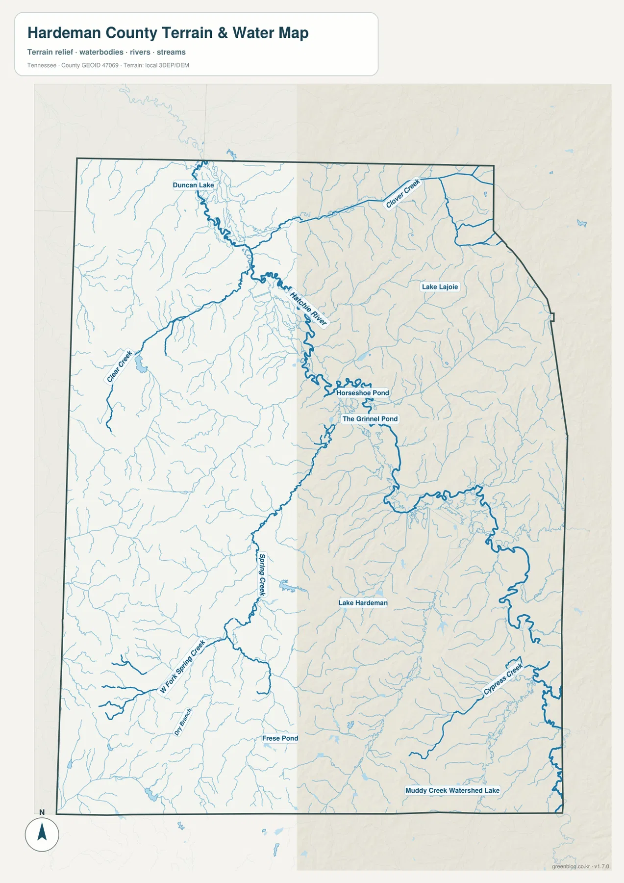
This water layer is intended for geographic reference rather than current water conditions. It does not establish flood limits, safe crossings, navigable access, or property boundaries. Its main value here is showing where the major river and creek valleys sit in relation to Bolivar, the southern towns, and the road network.
A 95–209 m range separates the Hatchie lowland from higher southwestern uplands
The elevation map shows an actual county range of about 95 to 209 meters, with a mean near 140 meters. The lowest green terrain follows the Hatchie River through the north and center. Short ridges and creek valleys rise on both sides, while tan and brown uplands become much more extensive toward the southwest and south.
The southwestern quarter contains some of the strongest higher terrain on the map. Around the Grand Junction and Hickory Valley side, rolling uplands are cut by many narrow drainages. Roads use the gentler spaces between those creek valleys, while the Hatchie corridor remains broader and lower by comparison.
The east and northeast are not as high as the strongest southwestern uplands, but they still contain repeated short ridges. Clover Creek and Cypress Creek occupy lower green corridors, with yellow-green and tan ground between them. Hardeman County is therefore better described as a low central river system surrounded by rolling uplands than as a county that simply rises from west to east or north to south.
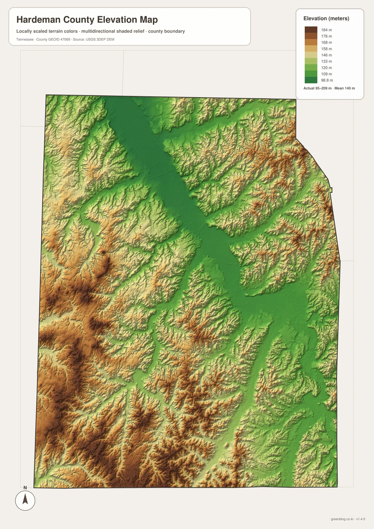
The terrain colors are intended for relative comparison across the county, not for a survey-grade elevation at a specific property. They are useful for matching the low Hatchie, Spring Creek, and Cypress Creek corridors with the roads that use those valleys and with the higher uplands that surround them.
Bolivar, the Hatchie corridor, and the southern towns create three useful map-reading zones
The city map first establishes Bolivar and Whiteville as the two largest ranked places and uses Toone, Middleton, Saulsbury, and Grand Junction to define the outer directions. The base map adds Routes 15, 57, 64, 100, and 125, while the water map places the Hatchie River through the center as the county’s strongest natural reference.
Adding elevation explains why the same road network looks different by area. The Whiteville–Bolivar side includes broad river and creek lowlands, the Grand Junction side becomes more rolling and elevated, and the Middleton side combines Cypress Creek valleys with short upland ridges. Those differences are easier to understand when towns, roads, water, and relief are viewed together.
Use the city map for ranked places and general orientation, the county map for roads and smaller communities, the water map for Hatchie River and its tributaries, and the elevation map for the contrast between the central lowland and the higher southern and southwestern terrain.
Choosing and downloading the A3 JPG maps
The WebP images in the article are convenient for quick viewing, while the JPG originals in the ZIP are better for printing, enlargement, and offline reference. For route notes, use the county map and mark only Bolivar, the destination, and the roads needed. Keep river and creek labels on the water map so they do not cover the road network.
The elevation image is especially useful in color because the Hatchie lowland and higher southwestern uplands are separated by terrain shading. A3 output also provides more room for labels such as Clara Creek, Spring Creek, Cypress Creek, and Routes 15, 57, 64, 100, and 125 than the browser preview.
The downloadable ZIP contains the high-resolution A3 JPG originals for the county, city, water, and elevation maps shown on this page. They can be used for classroom comparison, presentations, route notes, regional study, or personal offline storage when a larger image is more useful than the web preview.
Frequently Asked Questions
How are Bolivar and Whiteville shown on the city map?
Bolivar is ranked first at 5,144 residents and Whiteville second at 4,530. Bolivar is near the center of the county, while Whiteville lies farther west, so the map shows both the population difference and their separate positions.
How different is the Hatchie River lowland from the southwestern uplands?
The elevation map shows roughly 95–209 meters. The Hatchie corridor through the north and center is the lowest broad terrain, while the Grand Junction and Hickory Valley side in the southwest contains much more extensive higher rolling ground.
Sources and reference data
County boundaries and general location can be compared with U.S. Census Bureau TIGER/Line. Local history and county reference material are available from the Tennessee State Library and Archives Hardeman County fact sheet, and regional water information can be compared with the Tennessee Upper Hatchie Watershed reference.
For broader hydrography reference, see USGS National Hydrography. Elevation data can be compared with the USGS 3D Elevation Program. The descriptions on this page are based on the places, roads, water features, and elevation patterns visible in the supplied Hardeman County maps.
Map File Information
Download the high-resolution A3 JPG originals for the Hardeman County county, city, water, and elevation maps shown in this article.
- Included Files: County map, city map, water map, elevation map
- File Type: ZIP containing 4 JPG files
Related Maps
- Alamo to Gadsden: A Crockett County Tennessee Map
- Altamont, Monteagle, and Plateau Valleys — Grundy County Tennessee Map
- Around Chattanooga: Hamilton County Tennessee Map
Green Map creates custom-edited map images using open geographic data sources such as geoBoundaries, Natural Earth, OpenStreetMap, and government open data. These maps are edited visual materials, not raw data files, and are provided for education, documents, presentations, and graphic reference.