Amador County stretches eastward from rolling Sierra Nevada foothills into much higher mountain country, giving the county a strong west-to-east contrast. Most incorporated cities and historic Gold Country communities are concentrated in the western half around Jackson, Sutter Creek, Ione, Plymouth, and Amador City. Farther east, Pine Grove, Pioneer, Red Corral, and Buckhorn follow the main mountain road while town labels become sparse and ridges, streams, and reservoirs take over the map.
You can download the original high-resolution A3 JPG files from this Amador County Map page in one ZIP. The package contains the county reference map, city-distribution map, and terrain-and-water map. No separate elevation map is included in this county package, so the discussion of higher and lower terrain is based on the actual relief shading shown on the water map together with verified Amador County geographic information.
Table of Contents
Jackson sits at the center of Amador County’s western Gold Country towns
Jackson is the county seat and a practical place to begin reading the reference map. Amador County’s official profile identifies Jackson as the seat of government and describes it as a principal commercial center. On the map, Jackson sits close to Sutter Creek, with Amador City, Drytown, and Plymouth extending northward. The short spacing between these names gives the western foothills a much denser settlement pattern than the mountain country to the east.
Highway 49 helps tie those towns together. An official Amador County planning document describes State Route 49 as a north–south route linking Plymouth, Sutter Creek, Amador City, and Jackson along the Mother Lode corridor. Ione lies southwest of that chain near Routes 104 and 124, creating another major western center without sitting directly on the same Highway 49 line.
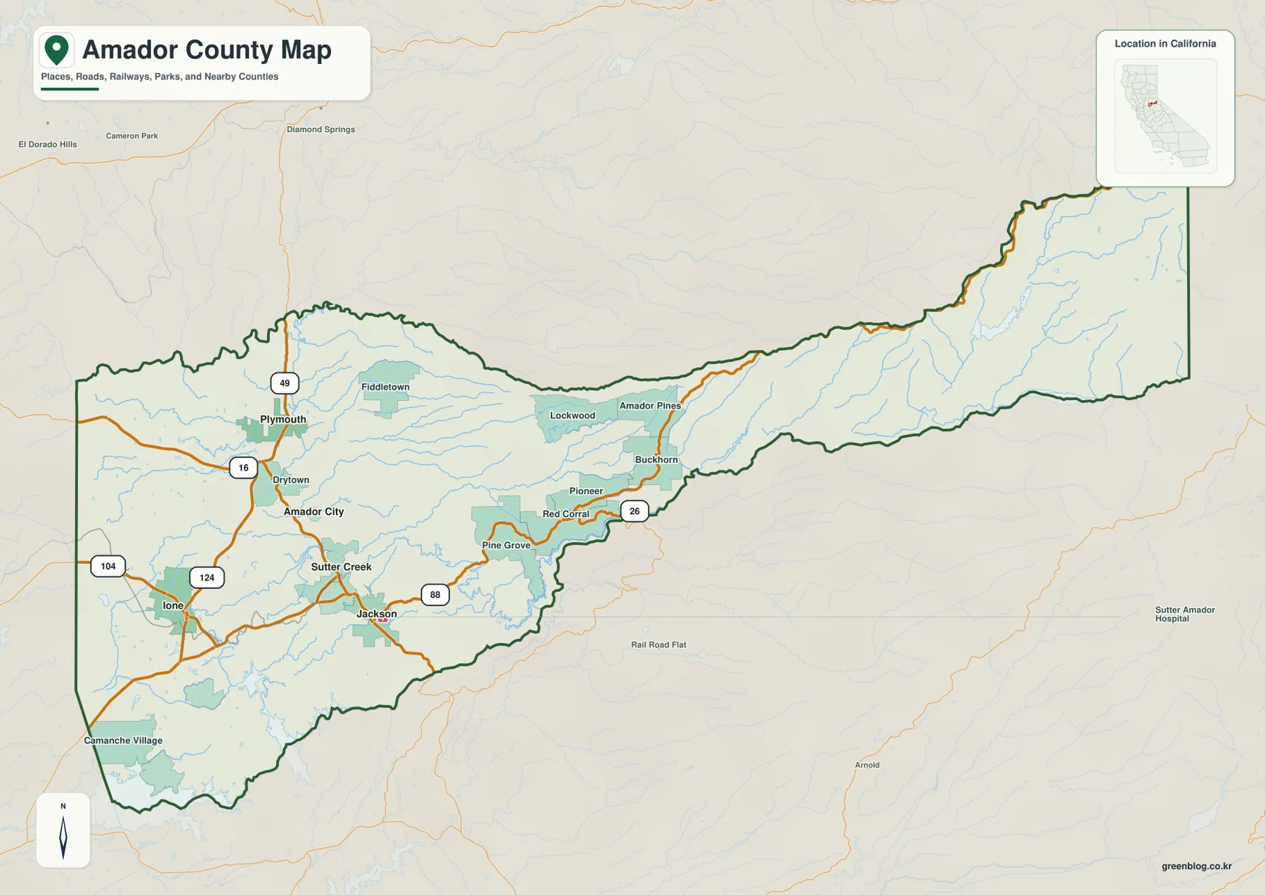
Plymouth lies near the northwestern part of the county, with Fiddletown east of it and Drytown farther south along the foothill road network. Camanche Village is near the southwestern edge. This western cluster can make Amador County look compact at first, but the boundary continues far beyond Jackson and Pine Grove, forming a long eastern extension where developed places become much less frequent.
Highway 88 carries the map from foothill towns into sparsely settled mountain country
East of Jackson, the character of the map changes quickly. Pine Grove appears first, followed by Red Corral, Pioneer, and Buckhorn along the main mountain route. Amador County planning material identifies State Route 88 as the major east–west highway through Jackson, Pine Grove, Pioneer, Red Corral, and Buckhorn on its way across the Sierra Nevada. The county reference map shows that route continuing through a progressively less developed landscape.
Lockwood and Amador Pines sit north of the main corridor, while Pioneer and Red Corral are closer to the through road. Beyond Buckhorn, large town labels nearly disappear. Relief and drainage lines occupy most of the eastern map. The county’s official profile says elevations rise from roughly 250 feet in the western part of Amador County to more than 9,000 feet in the eastern mountains, which explains why the terrain becomes dramatically rougher even though this package does not include a separate numeric elevation map.
This eastward reach is one of the most distinctive parts of Amador County. A visitor looking only at Jackson, Sutter Creek, and Ione might think of the county primarily as a small Gold Country foothill area. The full boundary shows something much larger: the county continues through forested uplands and mountain watersheds almost to the Sierra crest.
Ione ranks first on the supplied city map, while Jackson remains the county seat
The city-distribution graphic ranks five incorporated cities. Ione is shown first at 9,156, followed by Jackson at 5,048, Sutter Creek at 2,702, Plymouth at 1,056, and Amador City at 174. These are comparison values printed on the supplied graphic, not a substitute for the newest Census estimates, so current population work should use an official statistical source.
The geographic pattern matters more than the ranking alone. All five cities appear in the western half of Amador County. Jackson and Sutter Creek are close together, Amador City and Plymouth continue the chain northward, and Ione stands apart to the southwest. None of the incorporated cities shown in this ranked view occupies the long eastern mountain extension.
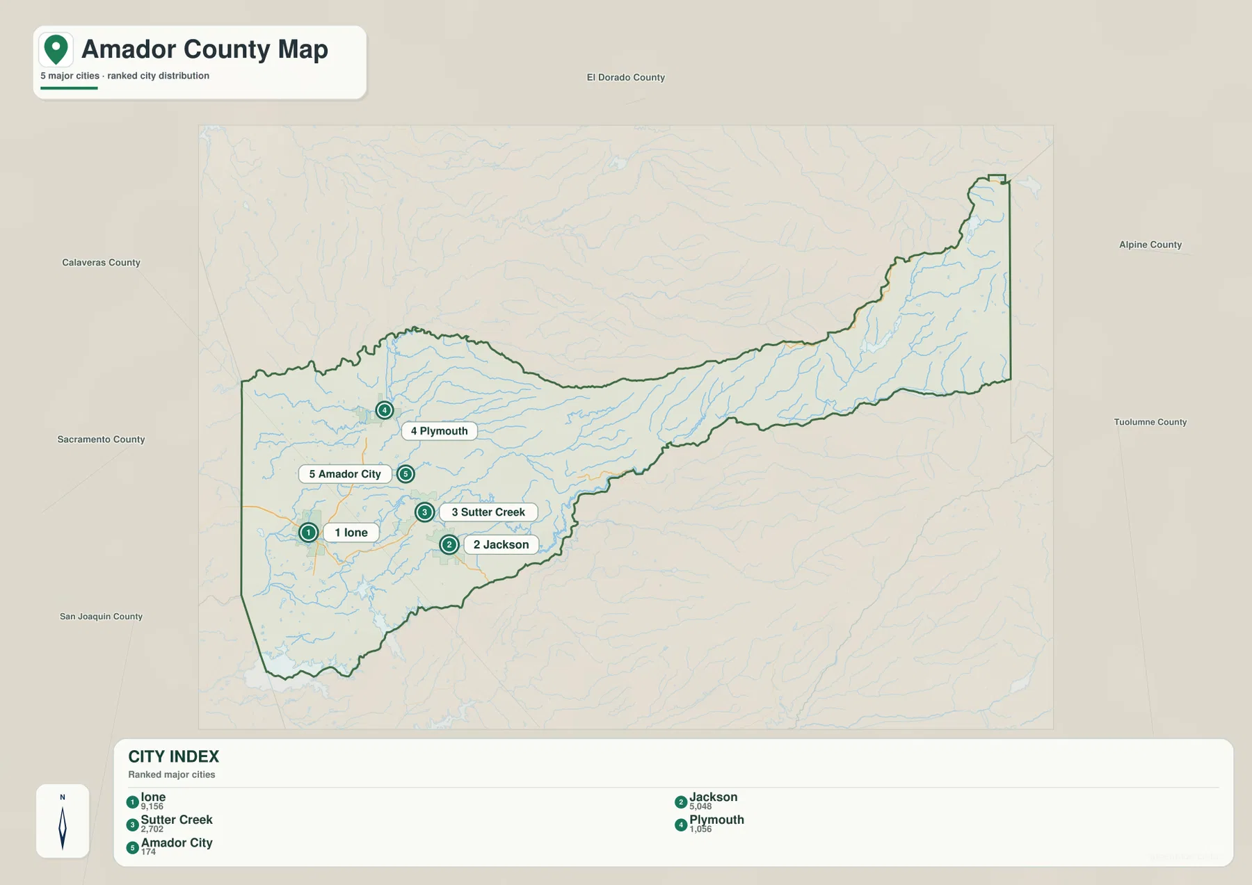
Amador County’s economic-development material also identifies five incorporated cities and describes Jackson as the county seat and a center of trade and government. That distinction is useful because the largest number printed on a city graphic does not automatically identify the administrative center. Use the city map for relative size and placement, and the county reference map for actual road connections and surrounding communities.
The Cosumnes and Mokelumne rivers frame the county from north and south
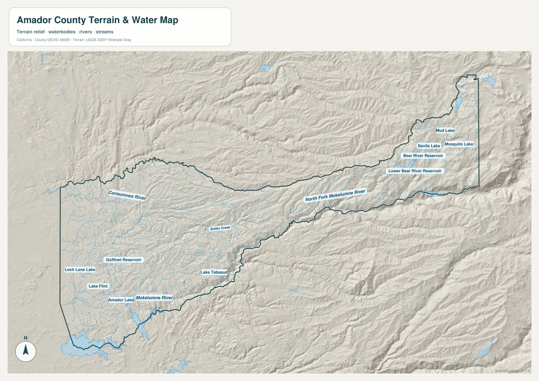
The county’s long shape becomes easier to understand when the major rivers are located. Amador County’s official profile states that the Cosumnes River forms the northern boundary and the Mokelumne River forms the southern boundary. The terrain-and-water map labels the Cosumnes across the north and the Mokelumne system along the southern side, giving the county two strong natural reference lines.
Farther east, the North Fork Mokelumne River is labeled along the mountainous southeastern side. Numerous short tributaries descend through steep terrain before reaching the larger river system. In the western foothills, drainage is more spread out across rolling terrain; in the eastern mountains, channels are confined to deeper, narrower valleys.
These river boundaries also help place the neighboring counties. El Dorado County is to the north, Calaveras County is to the south, and Alpine County meets the narrow eastern end. Sacramento and San Joaquin counties lie on the western side. The city map displays these surrounding county names clearly, while the terrain map shows why the north and south edges often follow natural drainage features rather than simple straight lines.
Sutter Creek and the western reservoirs sit close to the Gold Country settlement belt
The western half contains numerous smaller water features close to the towns. Sutter Creek is labeled through the foothill settlement area, while Goffinet Reservoir and Lake Tabeaud provide useful inland landmarks farther east of the main city cluster. Loch Lane Lake, Lake Flint, and Amador Lake are shown in the southwestern portion closer to the Ione and Camanche side.
These water bodies are useful because they connect the town map with the terrain map. Jackson and Sutter Creek sit within a network of small drainages rather than on a broad flat plain. Ione is farther west and southwest where the hills become gentler, while the terrain grows increasingly broken east of Lake Tabeaud toward Pine Grove and Pioneer.
The water image is a county-scale geographic reference, not a flood-hazard, parcel, navigation, or water-quality map. It is appropriate for locating rivers, reservoirs, lakes, and drainage corridors and comparing them with towns and roads. Current legal, safety, or property decisions require specialized information from the responsible agencies.
Bear River reservoirs and small mountain lakes mark the high eastern end
The far eastern part of the terrain map has almost none of the dense town pattern seen around Jackson. Bear River Reservoir and Lower Bear River Reservoir occupy long mountain valleys, with Devils Lake, Mosquito Lake, and Mud Lake labeled farther north. The surrounding relief is much more rugged, and short streams descend from closely spaced ridges.
The U.S. Forest Service describes Eldorado National Forest as extending from oak foothills on the west to the high Sierra crest, with extensive rivers, lakes, streams, and mountain terrain. Amador County is one of the counties containing portions of the forest. That regional description matches the supplied eastern terrain image, where reservoirs and drainage lines replace the tightly spaced urban labels of the western foothills.
Comparing the road and terrain maps is especially useful here. Jackson, Pine Grove, Pioneer, and Buckhorn provide a chain of recognizable place names on the reference map. Moving through those same locations on the terrain image shows the landscape becoming progressively more rugged until the eastern reservoirs and mountain watersheds dominate the scene.
A west-to-east reading keeps Amador County simple
A good first pass is to begin with Ione, Jackson, Sutter Creek, Amador City, and Plymouth in the western foothills. Highway 49 explains much of the north–south relationship among the Gold Country towns, while the roads around Ione establish the southwestern side. Once those places are familiar, the large amount of empty-looking space east of Jackson becomes easier to interpret.
Next, follow the main eastward route through Pine Grove, Pioneer, and Buckhorn. Switch to the terrain-and-water map and look for the increasingly close ridges, the North Fork Mokelumne River, and the Bear River reservoirs. This two-step approach shows that Amador County is not simply a cluster of historic towns; it is a long county spanning foothills, forests, river valleys, and high Sierra terrain.
Choose the file according to whether you need towns, roads, or mountain water features
The county reference map is the best starting point for Jackson, Ione, Sutter Creek, Plymouth, Pine Grove, Pioneer, major highways, nearby counties, and the boundary. The ranked city map is cleaner when the five incorporated cities are the main subject. The terrain-and-water image provides the strongest view of the Cosumnes and Mokelumne systems, western reservoirs, eastern mountain lakes, and the pronounced change from foothills to Sierra terrain.
For a lesson or regional presentation, the reference and terrain maps work especially well together. The western towns can be shown against rolling foothill drainage, while Pioneer and Buckhorn can be compared with the rougher eastern ridges. The rivers on the north and south sides also make the county’s elongated shape easier to explain without relying on a separate elevation map.
Each downloadable JPG measures 3638 × 2572 pixels and is suitable for A3 landscape printing, enlarging place labels, or placing a map in a report or classroom handout. Keep the original aspect ratio when resizing so roads, rivers, and the county boundary are not distorted. Printer margins vary, so checking one test page before a larger print run is useful.
Frequently Asked Questions
What is the county seat of Amador County, California?
Jackson is the county seat. It sits within the western Gold Country town cluster near Sutter Creek and is a useful starting point for following Highway 49 north and the main Sierra route east toward Pine Grove, Pioneer, and Buckhorn.
Which rivers form the main northern and southern boundaries?
Amador County’s official profile identifies the Cosumnes River as the northern boundary and the Mokelumne River as the southern boundary. The terrain-and-water map also shows the North Fork Mokelumne River along part of the mountainous eastern and southeastern side.
Does this download include a separate elevation map?
No. This Amador County package contains the county reference map, city-distribution map, and terrain-and-water map. The relief image shows the major difference between the western foothills and eastern Sierra mountains, but a separate numeric elevation map is not included.
Map File Information
The ZIP contains the original Amador County reference, city-distribution, and terrain-and-water maps as high-resolution JPG files.
- Included Files: County reference map, city-distribution map, terrain-and-water map
- Printable Size: 3638 × 2572 pixels each
- File Type: Three high-resolution JPG files in one ZIP archive
Related Maps
Sources and References
- Amador County – About – Official county information on Jackson, the Sierra Nevada setting, river boundaries, and the major west-to-east elevation change.
- Amador County Planning Area – Official route information for State Routes 49 and 88 through the county’s towns and Sierra corridor.
- Visit Amador – Towns & Regions – Local information on Jackson, Sutter Creek, Plymouth, Ione, Pioneer, and other Amador County communities.
- U.S. Forest Service – Eldorado National Forest – Official information on the Sierra landscape, forests, streams, reservoirs, and mountain terrain extending into Amador County.
- USGS National Hydrography – Official information about U.S. rivers, streams, lakes, and hydrographic data.
Green Map creates custom-edited map images using open geographic data sources such as geoBoundaries, Natural Earth, OpenStreetMap, and government open data.
These maps are edited visual materials, not raw data files, and are provided for education, documents, presentations, and graphic reference.