The Clark County Arkansas Map files on this page can be downloaded as a ZIP containing four high-resolution JPG originals. The maps focus on different parts of the same county: the general map shows places and major routes, the city map simplifies the settlement pattern, the water map highlights rivers and smaller channels, and the elevation map separates the higher northwest from the lower eastern side. Arkadelphia is the easiest place to use as a reference because it sits near several major routes and close to Caddo Valley, while Gurdon anchors the southern part of the county.
Clark County has a broad spread of named places rather than one tight cluster. Amity is near the northwest corner, Caddo Valley lies north of Arkadelphia, Gum Springs is just to the south, Okolona is farther southwest, and Gurdon is well down in the southern half. The road map makes those relationships clearer with numbered routes such as 30, 8, 26, 53, 67, 128, 182, 283, and 346. The water and elevation maps add another layer: Caddo River crosses the north, Ouachita River appears along the eastern side, Little Missouri River lies in the south, and the mapped elevation spans about 33 to 290 meters with a mean of about 92 meters.
The strongest terrain contrast is visible between the rougher northwestern uplands and the greener, lower ground in the east and southeast. Narrow ridges and valleys are especially noticeable across the western and northern portions of the elevation map. Farther east, the surface becomes broader and lower. That difference is useful when the maps are read together, because several streams and river corridors can be followed through lower parts of the terrain without turning the page into a technical GIS report.
Table of Contents
Arkadelphia is the clearest road reference for the northern half of Clark County
On the general county map, Arkadelphia stands out where several routes meet. Route 30 runs through the Arkadelphia area and continues north toward Caddo Valley and south toward Gum Springs. Route 8 extends west toward Amity, while routes 7 and 128 appear on the eastern side of the county. North of Arkadelphia, route 283 is shown near Caddo Valley. The map is most useful when these roads are treated as orientation markers rather than as a complete driving network.
The southern half has a different road pattern. Gurdon is the most prominent named place there, with routes 53 and 182 close to town and route 67 farther west. Route 51 appears near the southwest side, while Okolona lies northwest of Gurdon. These labels help separate the county into practical reference areas: Arkadelphia and Caddo Valley in the north and northeast, Amity in the northwest, and Gurdon in the south.
The boundary itself is irregular enough that the full county map is valuable even when a reader already knows the town names. A long eastern extension and several stepped northern edges make Clark County difficult to picture as a simple rectangle. The map keeps the county outline, named places, streams, and major route numbers on the same page, making it a good first choice for anyone who needs to understand where a location sits inside the county before moving to a more specialized map.
A useful way to read the road and terrain maps together is to compare the northwest corner with the eastern extension. Around Amity, routes 84 and 346 sit in a higher, more broken landscape, while the eastern side around routes 7 and 128 is much greener on the elevation map. Arkadelphia falls between those two settings, which makes it a practical midpoint for comparing how roads cross different parts of the county.
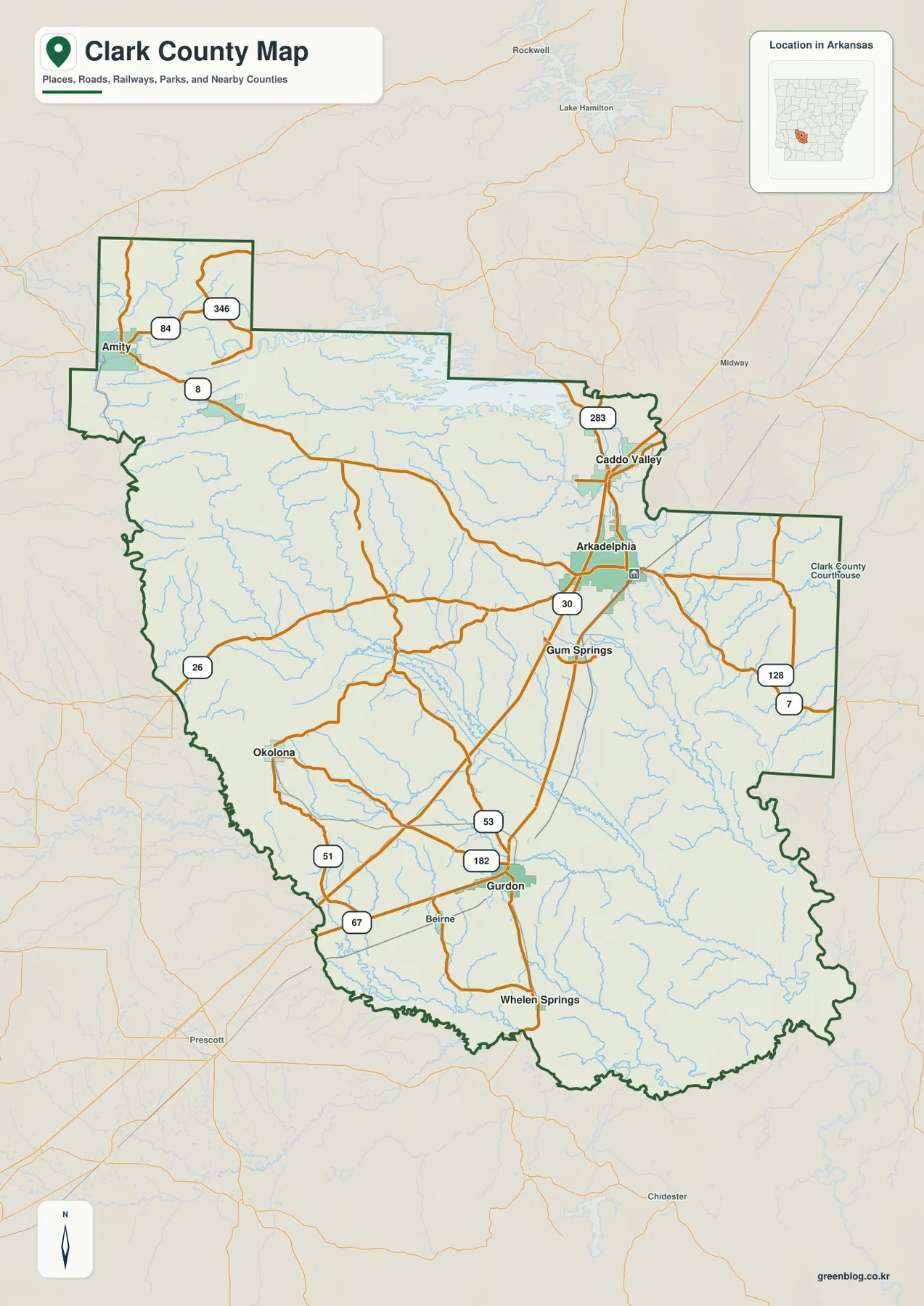
Six ranked places show how settlements are spread from Amity to Gurdon
The city map reduces the visual clutter and highlights six ranked places: Arkadelphia, Gurdon, Caddo Valley, Amity, Okolona, and Gum Springs. Arkadelphia is ranked first and Gurdon second, followed by Caddo Valley and Amity. Okolona and Gum Springs complete the six-place index. The ranking is printed directly on the supplied map, so the page can be read quickly without having to search through the denser road map.
The positions matter as much as the ranking. Arkadelphia and Caddo Valley form a close pair in the northeastern part of the county, with Gum Springs just south of Arkadelphia. Gurdon sits much farther south. Okolona is to the southwest of the main Arkadelphia area, while Amity is isolated near the northwestern edge. This pattern explains why a single “central town” description does not fully capture the county: useful reference points are spread across several directions.
Neighboring county names are also shown around the outside of the city map, including Hot Spring, Dallas, Montgomery, Garland, Pike, Ouachita, and Nevada counties. Those labels help readers place Clark County within the surrounding part of Arkansas. The map does not provide current driving times or turn-by-turn distances, so travel planning should still be checked with an up-to-date road service.
Caddo River, Ouachita River, and Little Missouri River frame three different parts of the county
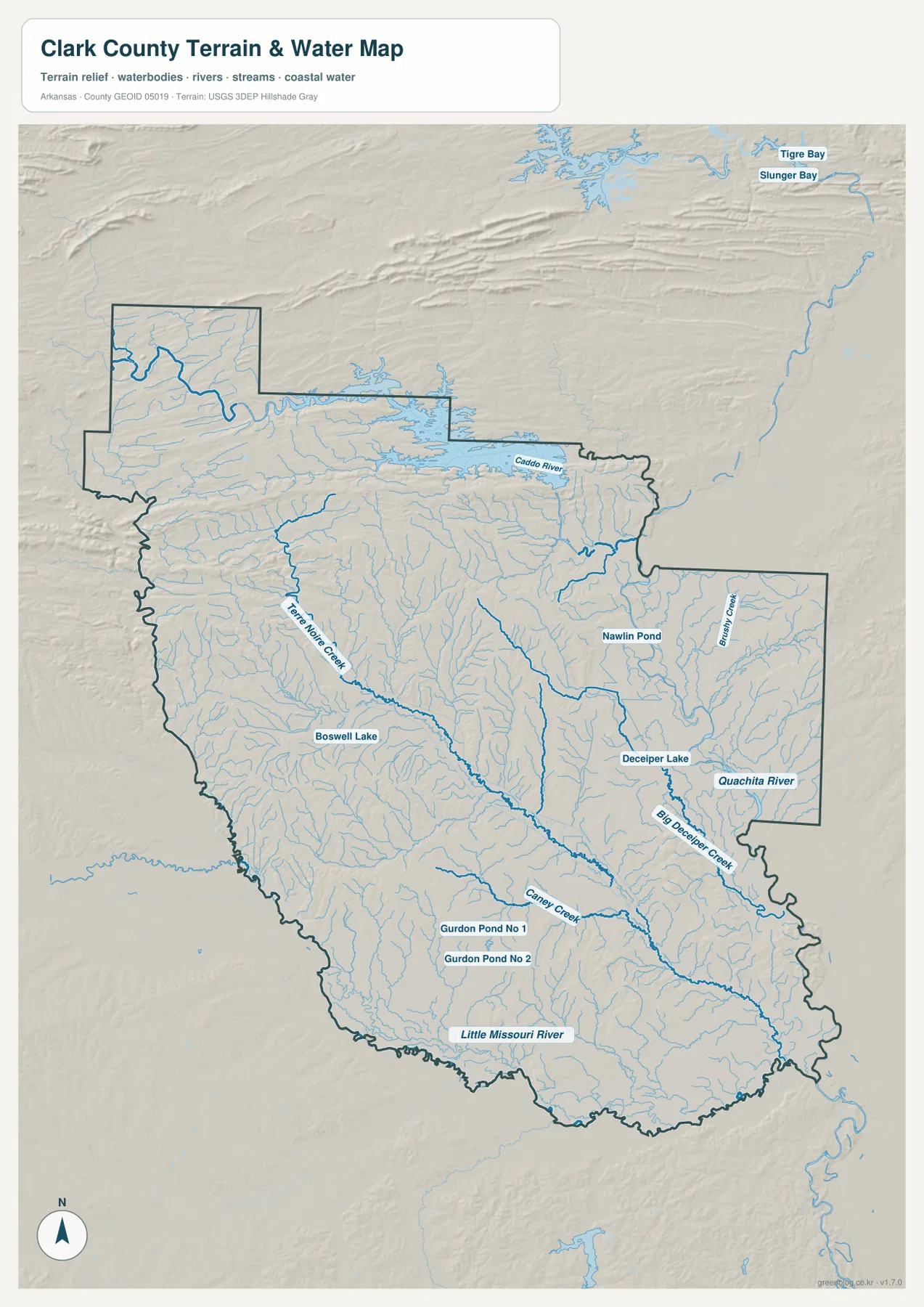
The water map gives Clark County a very different appearance from the road map. Caddo River is the most obvious named river across the northern portion, with many smaller tributaries feeding into the surrounding drainage. Terre Noire Creek runs through the central-western part of the county, and Caney Creek appears farther south. Numerous thin blue tributaries fill the spaces between the larger named channels.
Ouachita River is labeled on the eastern side, while Little Missouri River appears along the southern part of the map. Several smaller named water bodies are also visible, including Boswell Lake, Nawlin Pond, Gurdon Pond No 1, and Gurdon Pond No 2. These names are useful when a reader needs a geographic reference that is not a town or a highway. The map is especially effective for locating a stream in relation to the county outline and the broader terrain.
This is a reference map of waterways, not a flood or navigation product. The blue lines and water bodies indicate mapped rivers, creeks, ponds, and lakes, but they do not show live water levels, flood zones, legal shoreline limits, or safe boating conditions. Those questions require current official data. For general orientation, however, the map clearly shows how the three large named rivers occupy different parts of Clark County.
Elevation rises sharply toward the northwest and stays lower across much of the east
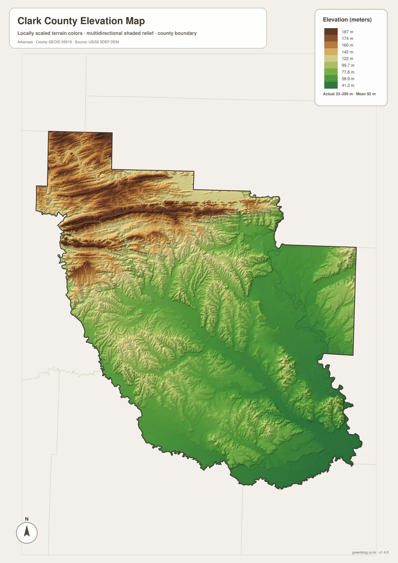
The supplied elevation map reports an actual range of about 33 to 290 meters and a county mean of about 92 meters. The northwest corner contains the strongest brown and tan colors, marking the highest ground on the page. Ridges also extend across much of the northern belt. The eastern section is dominated by green, showing a broad area that is lower than the western uplands.
Across the central and western parts of Clark County, narrow ridges and valleys repeat in a more broken pattern. Farther south, the relief is still visible but the color changes are generally less dramatic than in the northwest. The southeastern side remains mostly low, with smaller ridges interrupting the green surface. This makes the elevation map useful for explaining why two places that look close on a road map may sit in noticeably different terrain.
The elevation surface is designed for county-wide comparison, not for engineering or parcel-level measurement. It is appropriate for seeing the overall difference between higher ridges and lower valleys, but it should not be treated as survey-grade elevation. Construction, drainage design, or other work requiring precise ground heights should use the underlying USGS elevation data and site-specific measurements.
The county outline makes more sense when the neighboring counties are left on the page
The city map labels several neighboring counties outside Clark County: Hot Spring County to the north, Dallas County toward the northeast, Montgomery County to the east, Garland County farther southeast, and Pike, Ouachita, and Nevada counties around the western and southwestern sides. Those labels are useful because Clark County does not have a simple rectangular outline. The Amity area projects northward, the boundary steps down across the upper middle, and a broad eastern section extends beyond the narrower central part of the county.
Reading the boundary together with the town locations gives a better sense of scale. Amity sits close to the northwestern edge, Arkadelphia is near the northeastern half but still well inside the county, and Gurdon is deep in the southern section. Okolona is closer to the western side. This boundary context is especially helpful when a reader is trying to decide whether a road or water feature lies near the edge of Clark County or closer to its interior.
Arkadelphia and Gurdon reveal different details when the four map types are compared
Arkadelphia is road-focused on the general map, ranked first on the city map, and placed between the higher northwestern terrain and the lower eastern ground on the elevation map. The water map shifts attention away from streets and toward the Caddo River to the north and the tributaries crossing the county. That change in emphasis is useful: instead of trying to read every layer at once, a reader can use the same reference town to move from transportation to waterways and relief.
Gurdon provides another clear comparison. Routes 53 and 182 help locate it on the road map, while the city map marks it as the second-ranked place. On the water map, Gurdon Pond No 1 and Gurdon Pond No 2 appear nearby among smaller streams. The elevation map shows the southern area as generally lower than the rugged northwest, although local ridges and valleys remain visible. Together, those views give Gurdon a much clearer setting than a single map could provide.
Choose the map by the question you need to answer
For a first look at Clark County, start with the general map and find Arkadelphia. From there, follow route 30 north toward Caddo Valley and south toward Gum Springs, then look west toward Amity and south toward Gurdon. Once that framework is familiar, the city map gives a cleaner view of the six ranked places without the same amount of road detail.
The water map is the better choice for Caddo River, Ouachita River, Little Missouri River, Terre Noire Creek, and the smaller ponds and tributaries. The elevation map works best after that, because it shows how the higher northwest and lower eastern terrain relate to those waterways. Using the specialized maps separately keeps each task readable instead of forcing roads, settlements, rivers, and relief into one crowded image.
The downloadable ZIP contains the high-resolution JPG originals for all four maps supplied on this page. Each image measures 2572 × 3638 pixels, which gives more room for reading small place names, route numbers, water labels, and terrain colors than the WebP previews. The archive is convenient for printing, classroom use, presentation slides, reports, or personal reference when the full-size files are preferable to screenshots.
Frequently Asked Questions
Which map is best for comparing Arkadelphia, Gurdon, and Amity?
The city map is the quickest choice when you only need relative positions. Arkadelphia is in the northeastern part of the county, Gurdon is much farther south, and Amity is near the northwest corner. Use the general county map alongside it when you also need route numbers and the full boundary.
Can I see Caddo River, Ouachita River, and Little Missouri River on the same map?
Yes. All three are labeled on the supplied water map, with Caddo River in the north, Ouachita River on the eastern side, and Little Missouri River in the south. Smaller features such as Terre Noire Creek, Caney Creek, Boswell Lake, and the Gurdon ponds are also shown. The map is for geographic reference rather than live flood or navigation conditions.
Is the 33–290 meter elevation range suitable for surveying?
No. The elevation map is intended to compare terrain across the whole county and reports an actual mapped range of about 33 to 290 meters with a mean near 92 meters. It is useful for seeing higher ridges and lower valleys, but precise engineering or surveying work should use original USGS data and site measurements.
Map File Information
The ZIP contains high-resolution JPG originals of the county, city, water, and elevation maps supplied on this page.
- Included Files: county map, city map, water map, elevation map
- Printable Size: 2572 × 3638 px each
- File Type: JPG
Related Maps
Sources and reference data
Official boundary, road, and place data can be checked through the U.S. Census Bureau TIGER/Line Shapefiles. Water features are supported by the USGS National Hydrography, and elevation reference data are available from the USGS 3D Elevation Program. The county-specific descriptions on this page are based on the four Clark County maps supplied in the attached package.
Green Map creates custom-edited map images using open geographic data sources such as geoBoundaries, Natural Earth, OpenStreetMap, and government open data.
These maps are edited visual materials, not raw data files, and are provided for education, documents, presentations, and graphic reference.