Karnes County is easier to understand when the towns, roads, waterways, and elevation are viewed together rather than as separate facts. Karnes City sits near the center of the mapped county, Kenedy is immediately to the south, Runge lies to the east, and Falls City is northwest of the county seat. This page provides a Karnes County Map set that lets you compare those locations with the San Antonio River system and the county’s terrain. After reviewing the maps on the page, you can download the A3 high-resolution JPG files together in one ZIP archive.
The four maps emphasize different parts of the same landscape. The general county map is useful for roads and nearby places, the city map simplifies the relationship among the four labeled communities, the water map brings the San Antonio River and its tributaries to the foreground, and the elevation map shows a local range of about 51 to 181 meters with a mean of about 108 meters. Used side by side, they make the county’s long northern extension, central town cluster, branching streams, and higher ridges much easier to distinguish.
Table of Contents
Start with Karnes City and the central road junction
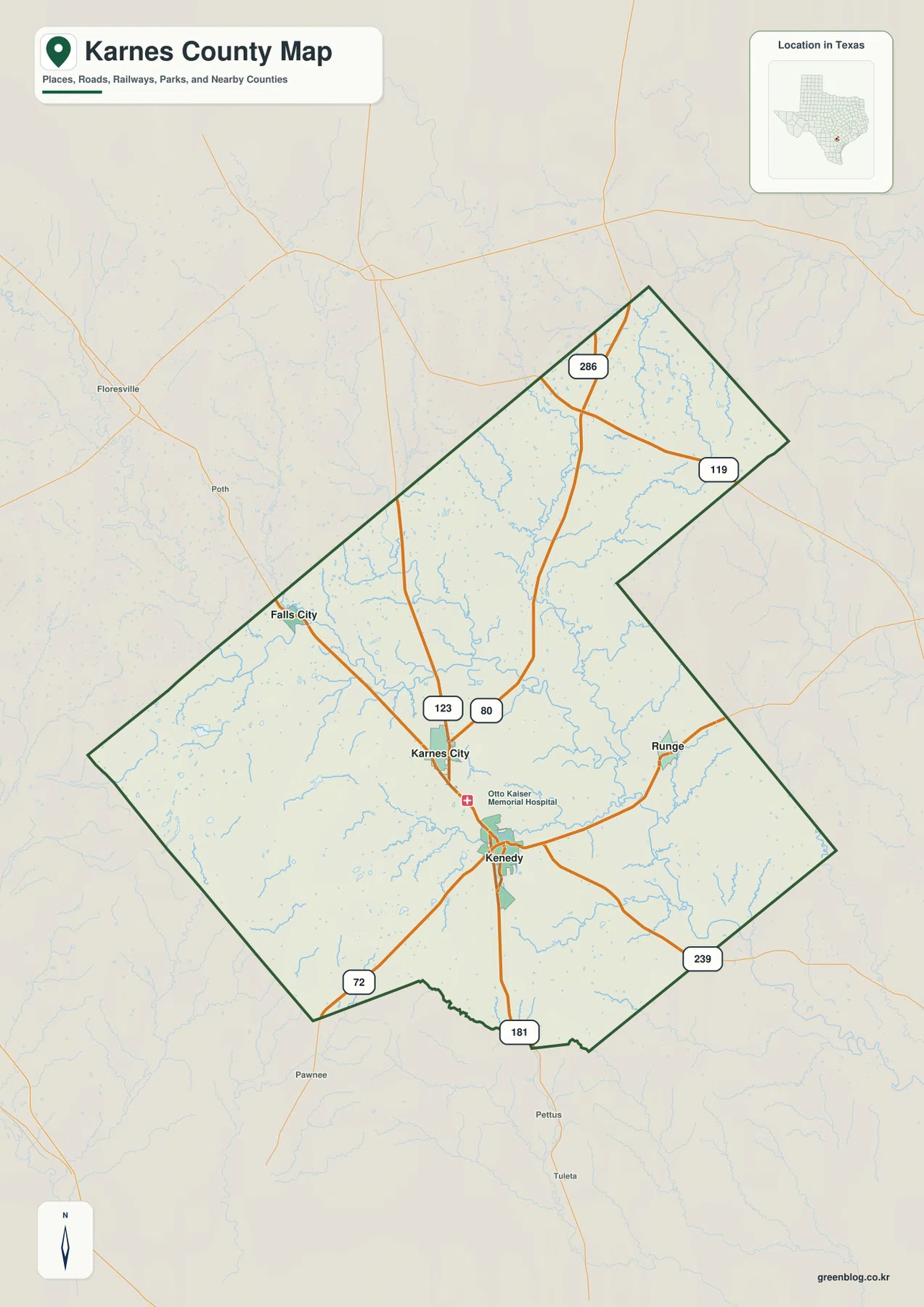
On the general county map, Karnes City is the most practical starting point because several labeled routes come together near the middle of the county. Route numbers 123 and 80 appear close to the city, while the main north-south line continues through Kenedy and reaches the southern boundary near the 181 marker. That arrangement makes the Karnes City–Kenedy pair stand out before you even begin looking at the smaller roads or drainage lines.
The county does not form a simple compact block. Its northern section extends far above the central towns, with route markers 286 and 119 appearing in that upper portion. To the southwest, the 72 marker sits near the county edge, while 239 appears toward the southeast. Falls City is northwest of Karnes City, and Runge is east of the central pair. Outside the boundary, the background map also shows places such as Floresville, Poth, Pawnee, and Pettus, which provide useful orientation when you want to see where a road continues after leaving Karnes County.
Kenedy, Runge, and Falls City show how the towns are spread out
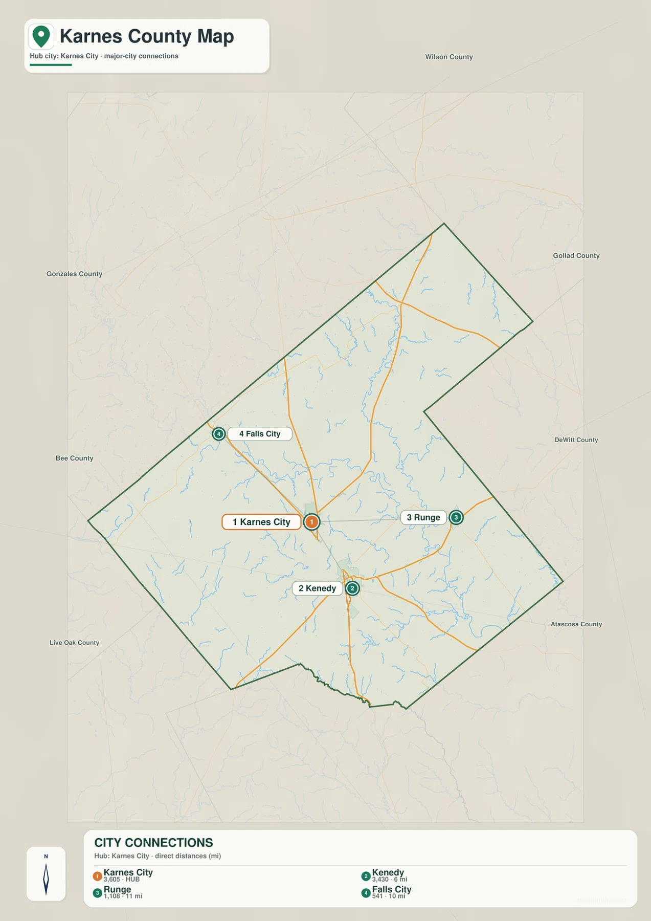
The city connection map removes much of the background detail and makes the settlement pattern easier to see. Karnes City is the hub on this version. Kenedy is only a short distance to the south, Runge is farther east, and Falls City is northwest. The visual separation matters because a reader who sees only a list of town names may assume that they are clustered together. The map makes it clear that the county’s main named communities occupy different sides of the central area.
Neighboring counties also help with orientation. Wilson County is shown to the north, Gonzales County to the west and northwest, Bee County to the west, Live Oak County to the southwest, Atascosa County to the southeast, and DeWitt and Goliad counties along the eastern side. Runge sits closer to the eastern boundary than the other three highlighted towns, while Falls City is positioned toward the northwestern side. That contrast is useful when matching a town with the direction of travel beyond the county line.
Following routes 123, 80, 181, 72, and 239 across the county
The route labels are most useful when they are tied to destinations instead of treated as a list. Around Karnes City, the 123 and 80 markers help identify the central junction area. Moving south toward Kenedy, the strong north-south corridor continues toward the 181 marker at the county’s southern edge. Another line leaves the Kenedy area toward the southwest and reaches the 72 marker, while the road toward the southeast is associated with 239. Runge is connected on the eastern side of this network rather than lying on the same north-south line as Karnes City and Kenedy.
The northern extension is different. It contains fewer highlighted towns but still has clear route references, including 286 and 119. This is one reason the full county map is useful even if your main interest is Karnes City: it shows that the administrative boundary continues a considerable distance north of the central town cluster. For classroom exercises or trip planning, marking a town first and then tracing the route toward a numbered edge point is often more intuitive than trying to memorize the road network all at once.
The San Antonio River and Ecleto Creek organize the water map
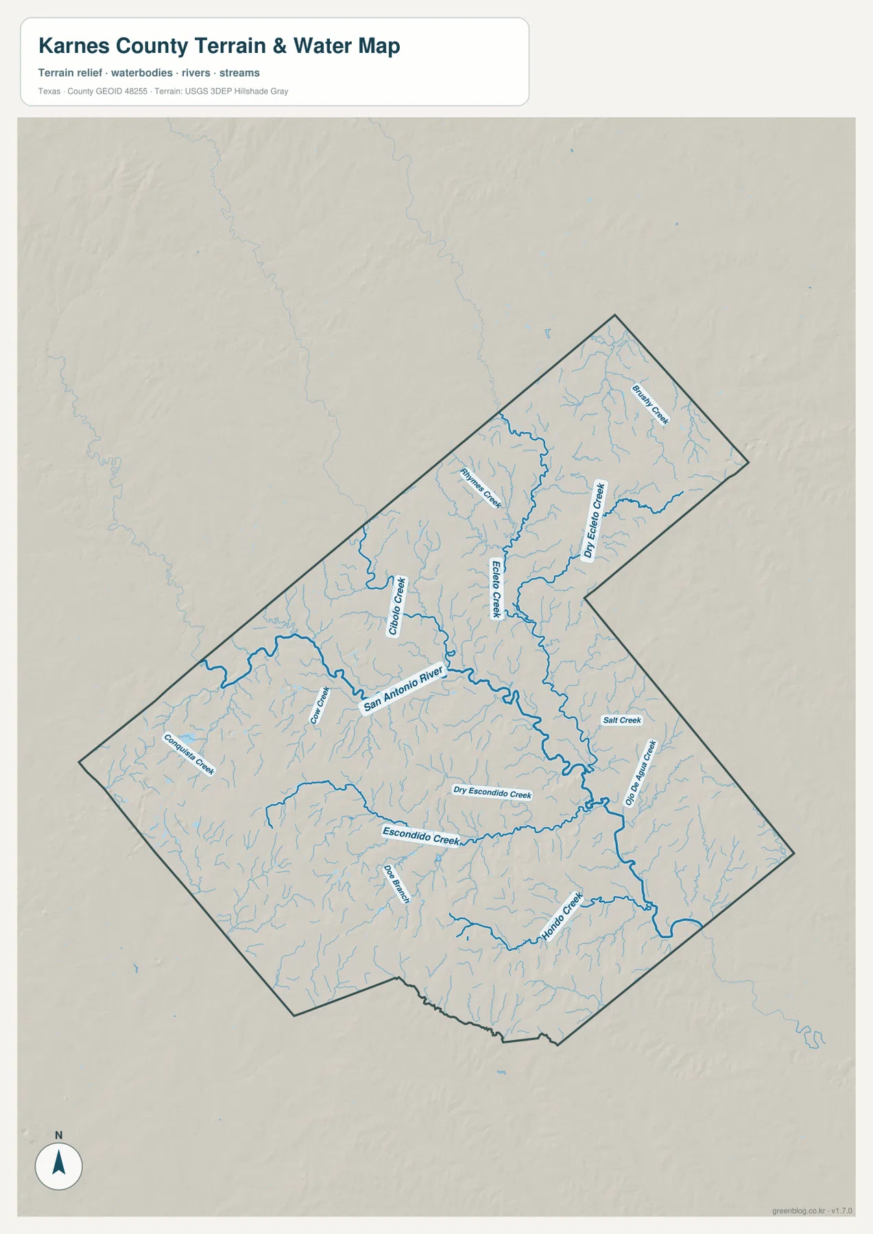
The water map changes the emphasis completely. The San Antonio River is the most prominent channel, winding through the middle of the county and then continuing toward the southeast. Ecleto Creek and Dry Ecleto Creek approach from the northern and northeastern part of the county. The map also labels a number of smaller waterways, including Panther Creek and Cibolo Creek to the west of the Ecleto system, plus Escondido Creek and Dry Escondido Creek farther south. Hondo Creek and Salt Creek are among the additional names visible in the southern and southeastern drainage network.
This dense branching pattern explains why the water version adds information that the road map cannot provide. Small tributaries reach into areas with few town labels, so the county appears much more finely divided when its drainage is shown. Ecleto Creek is especially useful as a geographic reference because it runs southeast and joins the San Antonio River system in Karnes County. The Handbook of Texas also identifies its mouth on the San Antonio River west of Runge, which fits the relationship visible on the supplied water map.
If your goal is simply to locate Karnes City or Kenedy, the water map may contain more detail than you need. If you are comparing terrain, river crossings, or the placement of named creeks, however, it is the clearest of the four files. It also pairs well with the elevation map because the lower channels and valleys become easier to recognize once you know where the main river and tributaries run.
Lower river corridors contrast with higher ridges on the southwest and east
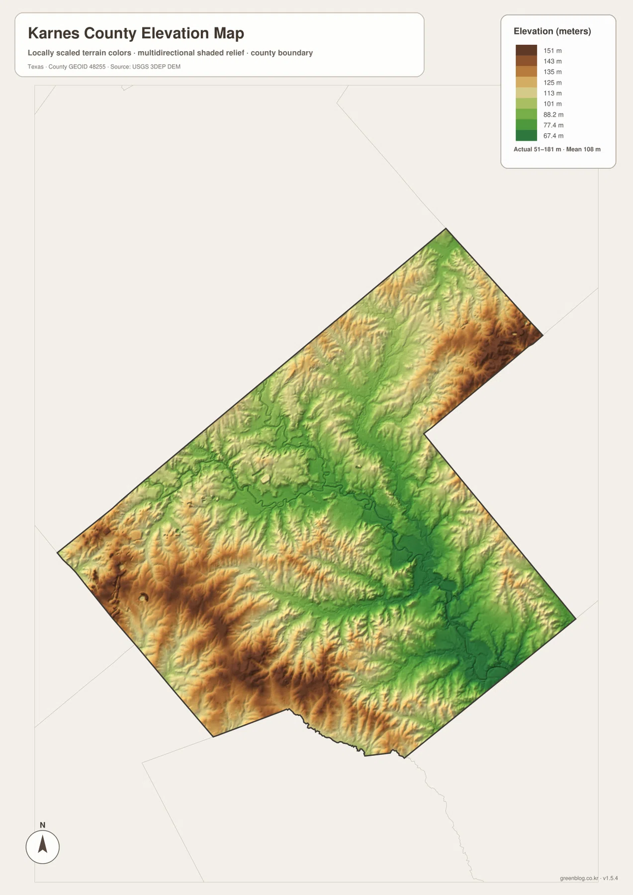
The elevation map uses a locally scaled color range rather than town labels. Its legend reports an actual range of approximately 51 to 181 meters and a mean elevation of about 108 meters. Greens mark the lower parts of the landscape, while tan and brown areas are higher. The broad central river corridor is mostly green, and several narrow low areas branch away from it in shapes that resemble the drainage network on the water map.
The southwest is notably different. Broad brown and orange ridges occupy that part of the county, with smaller valleys cutting through them. Higher ground also appears along portions of the eastern and northeastern sides. The result is not a simple slope from one corner to another; instead, higher ridges surround a network of lower valleys. That is why the shaded relief is more informative here than a single county-wide average elevation would be.
Comparing the water and elevation maps side by side is especially useful in the middle and southern parts of the county. The San Antonio River and its tributaries generally follow the lower green corridors, while the higher brown surfaces stand away from those channels. The maps do not replace detailed surveying or flood information, but they do provide a clear visual explanation of why streams occupy particular low paths through the county.
Choose the map that matches the question you are trying to answer
For a broad location check, start with the general county map because it combines town names, route numbers, streams, the county outline, and nearby places. The city connection map is better when you want a cleaner view of the direction from Karnes City to Kenedy, Runge, or Falls City. It removes much of the surrounding detail, so it works well for a classroom handout or a quick orientation page.
The water map is the better choice for the San Antonio River, Ecleto Creek, Escondido Creek, and the smaller tributaries that spread across the county. The elevation map is designed for a different task: comparing low valleys with higher ridges and seeing the local relief that is difficult to infer from a flat road map. Because all four JPG files are included in the download ZIP, you do not have to choose only one before downloading. You can print the general map for reference and keep the specialized versions for closer comparison.
The A3 format is useful when labels need to remain readable in print or when you want to mark routes, towns, or drainage features by hand. For education, one practical exercise is to locate the four highlighted towns on the city map and then match them to the river and elevation maps. For personal research, the general map can establish the county boundary and road direction before you move to official datasets for property, engineering, flood, or real-time travel decisions. These maps are geographic reference materials, not substitutes for legal surveys or current road advisories.
Frequently Asked Questions
Which towns should I locate first on a Karnes County map?
Start with Karnes City near the center, then find Kenedy just to the south, Runge to the east, and Falls City to the northwest. Those four points give you a simple frame for understanding the road network and the directions toward neighboring counties.
What are the most visible waterways on the supplied water map?
The San Antonio River is the strongest central feature. Ecleto Creek and Dry Ecleto Creek are prominent in the northern half, while Escondido Creek, Dry Escondido Creek, Hondo Creek, Salt Creek, and other smaller tributaries appear farther south and east.
What elevation range does the Karnes County elevation map show?
The supplied elevation map reports an actual range of about 51 to 181 meters and a mean of about 108 meters. Lower green areas follow much of the central drainage network, while higher brown ridges are more noticeable in the southwest and along parts of the eastern side.
Sources and Reference Data
- Karnes County official website — County government and official local information.
- U.S. Census Bureau TIGER/Line Shapefiles — Official geographic files used for boundaries, roads, and related mapping.
- USGS National Hydrography — Federal hydrography data for rivers, streams, and connected water features.
- USGS 3D Elevation Program — Official elevation data and terrain resources.
- Handbook of Texas: Ecleto Creek — Historical and geographic reference for Ecleto Creek and its connection to the San Antonio River.
Map File Information
Download the Karnes County general, city, water, and elevation maps as one ZIP containing four high-resolution A3 JPG files.
- File Type: ZIP with four JPG files
Related Maps
- Atascosa County Texas map
- Wilson County Texas map
- Refugio County Texas map
- San Patricio County Texas map
- Victoria County Texas map
Green Map creates custom-edited map images using open geographic data sources such as geoBoundaries, Natural Earth, OpenStreetMap, and government open data.
These maps are edited visual materials, not raw data files, and are provided for education, documents, presentations, and graphic reference.