Mitchell County sits in southwest Georgia, and the supplied maps make its internal layout easy to follow without treating the county as a single flat shape. Camilla is the central hub and county seat, Pelham lies to the south, Baconton to the north, and Sale City to the east. Along the western and northwestern side, the county boundary bends with the Flint River, while the elevation map shows noticeably higher ground toward the east and southeast.
This page uses four complementary maps to explain those relationships rather than simply listing place names. The county map shows roads, communities, and the boundary; the city map compares Camilla with Pelham, Baconton, and Sale City; the terrain-and-water map traces the Flint River and smaller streams; and the elevation map shows an actual range of about 30 to 123 meters with a mean near 66 meters. You can download all four original high-resolution JPG maps together in one ZIP file after the map guide.
The source material also identifies Mitchell County as an 1857 county and describes agriculture, food processing, the Flint River basin, and regional highways as important parts of its local setting. Rather than expanding those background points into generic county history, the guide below stays close to what the maps actually show: where the towns sit, how the roads spread from Camilla, where the water network becomes dense, and how the terrain rises toward the eastern side.
Table of Contents
Camilla as the road hub in the middle of the county
The general county map immediately centers attention on Camilla. The Mitchell County Courthouse and Sheriff’s Office are labeled nearby, reinforcing its role as the county seat, and several numbered roads spread outward from the same central area. Route labels including 19, 37, 65, 93, 112, and 300 help orient the viewer as roads head north toward Baconton, south toward Pelham, east toward Sale City, and west toward the irregular county edge.
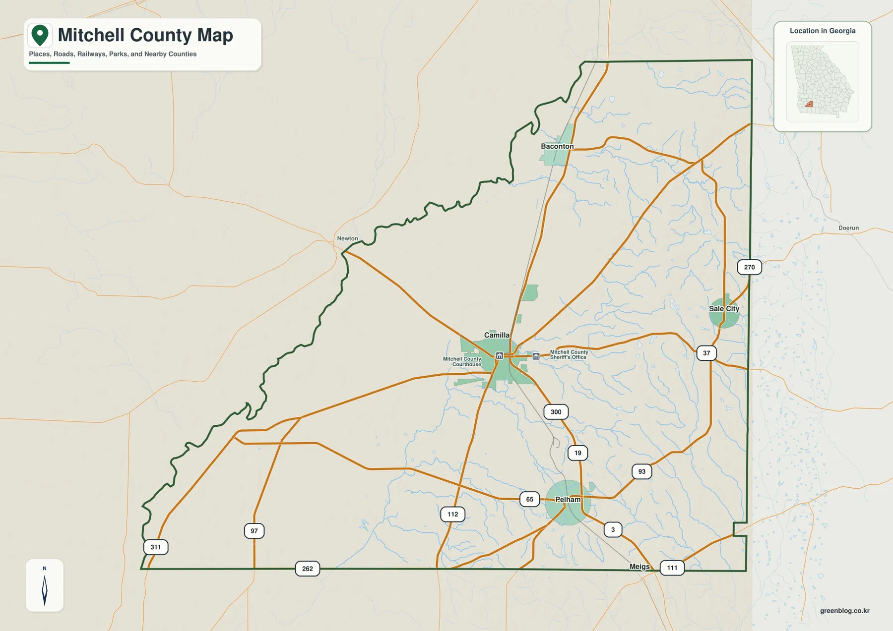
The county outline is especially useful when compared with the water map. The western edge is not a simple straight administrative line; it twists and bends for a long distance, and the Flint River map explains why. The eastern side is much straighter by comparison. Roads continue across the boundary toward nearby places such as Newton, Doerun, and Meigs, so the county map also shows that Mitchell County is connected to surrounding southwest Georgia rather than functioning as an isolated road network.
That makes this map most useful as a county-scale reference, not a parcel or local-street product. It gives enough road detail to understand the main travel directions and enough place labels to establish orientation, but it does not attempt to label every rural road, unincorporated settlement, property boundary, or service location. For a visitor trying to understand where Camilla sits in relation to the rest of the county, the broad road pattern is more informative than a dense street-level display would be.
A north-south town pattern with Sale City off to the east
The city-connections map simplifies the county by treating Camilla as the hub and marking three other named communities around it. Pelham is south of Camilla, Baconton is north, and Sale City sits to the east. The distance panel uses direct, straight-line distances rather than road mileage: Pelham is shown about 9 miles from Camilla, Baconton about 10 miles, and Sale City about 11 miles away. Driving distances will be longer when the road route does not follow a straight line.
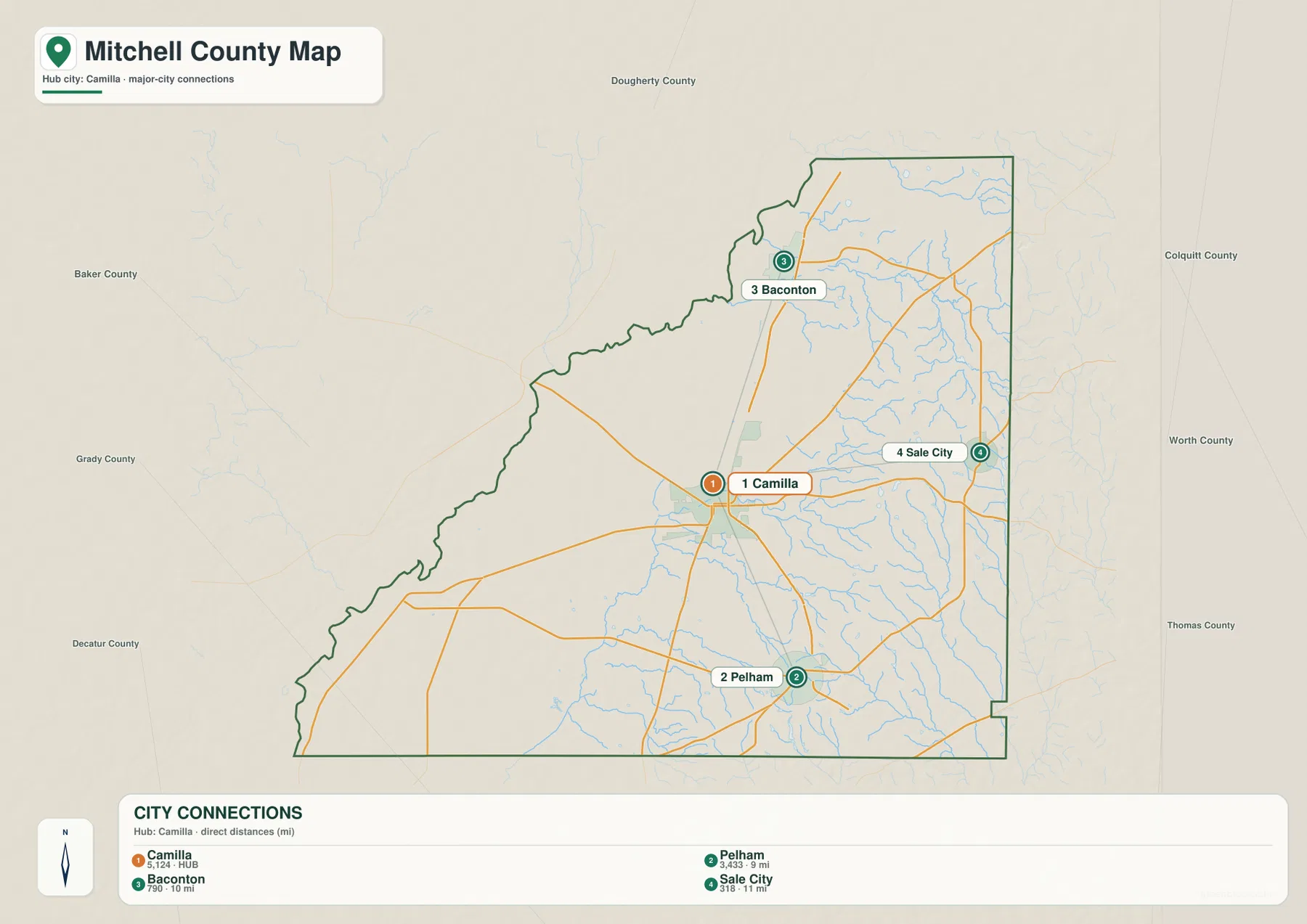
The surrounding county labels add another layer of orientation. Dougherty County appears to the north, Baker County to the northwest, Decatur and Grady counties to the southwest and west, Colquitt and Worth counties to the east, and Thomas County toward the southeast. Those labels help explain why roads leave Mitchell County in several directions and why Camilla and Pelham serve as useful reference points for travel across this part of southwest Georgia.
The settlement pattern is not evenly spaced. Baconton and Pelham form a rough north-south relationship through the central part of the county, while Sale City shifts the pattern eastward. When the city map is compared with the general road map, the difference is clear: the Camilla-to-Pelham and Camilla-to-Baconton connections emphasize a vertical movement through the county, while the Camilla-to-Sale City connection crosses toward the eastern side. This is a better description of the county’s town pattern than simply listing four municipalities in a row.
The Flint River boundary and a finer web of eastern streams
The terrain-and-water map separates Mitchell County into two very different water settings. The Flint River is the dominant feature along the west and northwest, where it follows the county boundary for a long stretch. Its broad meanders match the irregular outline seen on the county map. Outside the county on the western side, labels such as Halls Slough and Sea Pond appear, while many narrower stream lines occupy the interior.
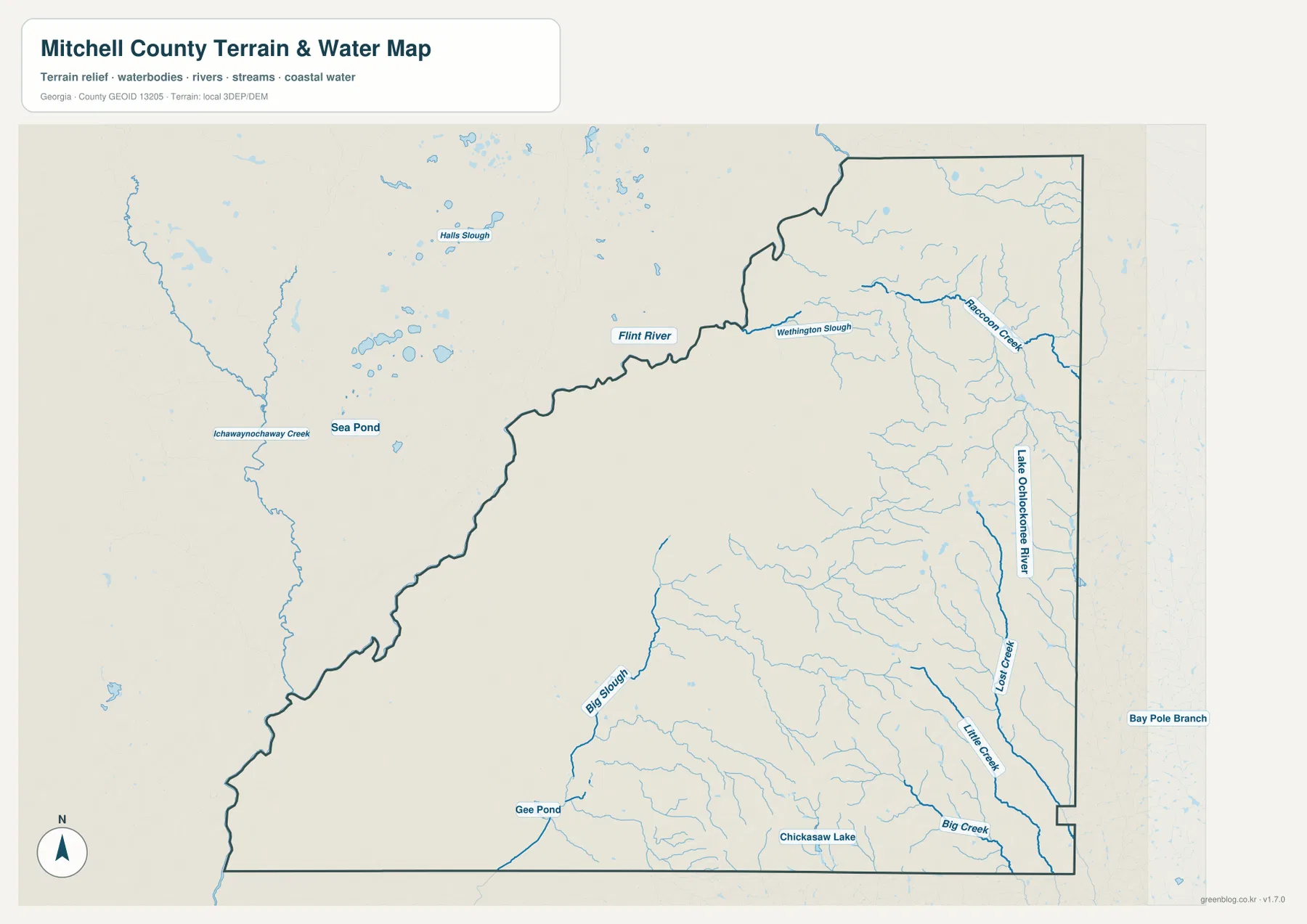
Inside the county, Raccoon Creek is labeled in the northeast, and the southeastern half includes the Lake Ochlockonee River, Long Branch, Little Creek, and Big Creek. Big Slough, Gee Pond, and Chickasaw Lake are also marked in the southern portion. Together, those labels show that the county’s water geography is not defined by the Flint River alone. A large boundary river dominates the western side, but a much finer network of creeks and smaller water features spreads through the interior.
This is a reference map for the locations and relationships of waterways, not a flood-risk, navigation, parcel, or legal-water-boundary product. Its value is in showing where the named streams lie and how their pattern relates to the county outline. The map becomes particularly useful beside the elevation layer because the smaller eastern streams run through the part of Mitchell County where the terrain changes most strongly.
Higher ground builds along the east and southeast
The elevation map gives Mitchell County a much more varied appearance than the road map alone suggests. Its legend reports an actual elevation range of roughly 30 to 123 meters and a mean near 66 meters. Green shades dominate the western and central sections, indicating the lower part of the local range, while yellow, tan, and brown become increasingly common toward the east and especially the southeast.
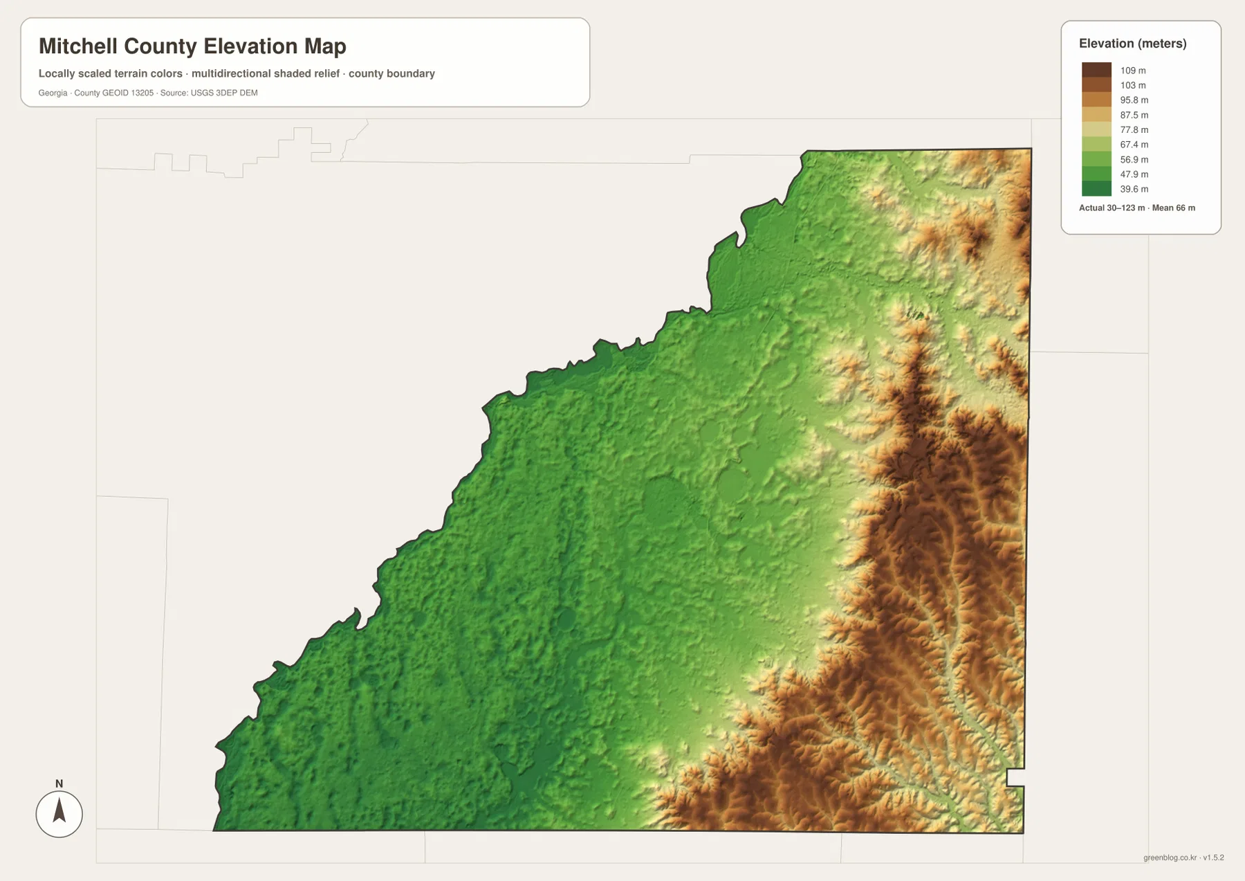
The higher eastern zone is not a single smooth ridge. Shaded relief reveals many smaller ridges, valleys, and branching depressions, creating a rougher texture than the western side. The contrast is strongest when the map is read from west to east: land near the Flint River side is broadly lower, the middle of the county transitions through moderate elevations, and the eastern edge contains much of the highest terrain shown.
The water and elevation maps reinforce one another. The Flint River occupies the low western side, while the more intricate drainage network in the east and southeast crosses terrain with greater relief. The elevation surface is generalized for county-scale comparison, however. It should not be treated as survey-grade or engineering-grade elevation information for construction, drainage design, or exact site measurements. For those tasks, the underlying elevation data or professional survey information is the appropriate source.
What the four maps reveal when read together
Seen together, the maps give Mitchell County a clear geographic structure. Camilla is the central road and administrative hub. Pelham anchors the south, Baconton the north, and Sale City provides an eastern reference point. The Flint River forms much of the irregular western boundary, while a finer pattern of streams fills the eastern half. At the same time, the elevation surface rises from the lower Flint River side toward distinctly higher ground in the east and southeast.
Each map is therefore suited to a different first question. Use the county map when you need roads, the boundary, and named places together. Use the city map when the priority is the direction and straight-line distance from Camilla to Pelham, Baconton, or Sale City. The terrain-and-water map is the better choice for the Flint River and tributary network, while the elevation map makes the west-to-east height contrast much easier to see.
For the strongest geographic reading, pair maps instead of relying on one layer for everything. The general map and water map explain why the western boundary bends so sharply. The water and elevation maps show how the dense eastern drainage lies within the county’s higher and more dissected terrain. The city and road maps clarify why Camilla works as the central reference even though the other towns lie in distinctly different directions.
Frequently Asked Questions
Are the distances from Camilla to Pelham, Baconton, and Sale City driving distances?
No. The city-connections map labels straight-line distances from Camilla. Pelham is shown at about 9 miles, Baconton at about 10 miles, and Sale City at about 11 miles. Actual driving mileage depends on the road route and will generally be longer.
Does the Flint River run through the middle of Mitchell County?
The supplied water map shows the Flint River mainly along the western and northwestern county boundary rather than through the center. Comparing it with the general county map explains why that side of the boundary has a long, irregular, meandering shape.
What is the main elevation difference shown on the map?
The western and central portions are generally lower, while the east and southeast contain much of the highest terrain. The map reports an overall range of about 30 to 123 meters with a mean near 66 meters. Those values are intended for county-scale comparison rather than precise site measurement.
Sources and Reference Links
For county statistics and background, see the U.S. Census Bureau QuickFacts page for Mitchell County and The New Georgia Encyclopedia entry for Mitchell County. Official mapping references include the U.S. Census Bureau TIGER/Line Shapefiles, USGS National Hydrography, and the USGS 3D Elevation Program.
Map File Information
Download the four original high-resolution JPG maps for Mitchell County in one ZIP file. The archive includes the county map, city-connections map, terrain-and-water map, and elevation map for printing, study, and general geographic reference.
- Included Files: Four high-resolution JPG maps
Related Maps
Green Map creates custom-edited map images using open geographic data sources such as geoBoundaries, Natural Earth, OpenStreetMap, and government open data. These maps are edited visual materials, not raw data files, and are provided for education, documents, presentations, and graphic reference.