Monroe County sits in central Georgia, with Forsyth near the middle of the county and roads spreading outward toward Juliette, Bolingbroke, Smarr, Culloden, and neighboring counties. The maps on this page separate that geography into four useful views: county boundaries and roads, the ranked city distribution, waterways, and elevation. If you need the full-size files rather than the WebP previews, you can download one ZIP containing four high-resolution A3 JPG maps.
The county is not shaped like a simple rectangle. Its western side steps outward around the Culloden area, the southeastern edge runs diagonally, and the eastern boundary is much more irregular. Those boundary changes matter because Forsyth, Culloden, Juliette, and Bolingbroke occupy very different parts of the county. The road map makes those relationships easy to locate, while the water and elevation maps explain why the land itself looks more varied than a standard place-name map suggests.
Table of Contents
Forsyth at the center of the county road network
Forsyth is the county seat and the clearest transportation hub on the general county map. I-75 runs through the county and passes Forsyth before continuing toward the southeast, while I-475 appears farther south and east. Route shields for 41, 18, 19, 23, 42, 74, 83, 87, and 341 add another layer of orientation. Rather than forming one dominant east–west line, the roads fan out from the central part of the county toward several different edges.
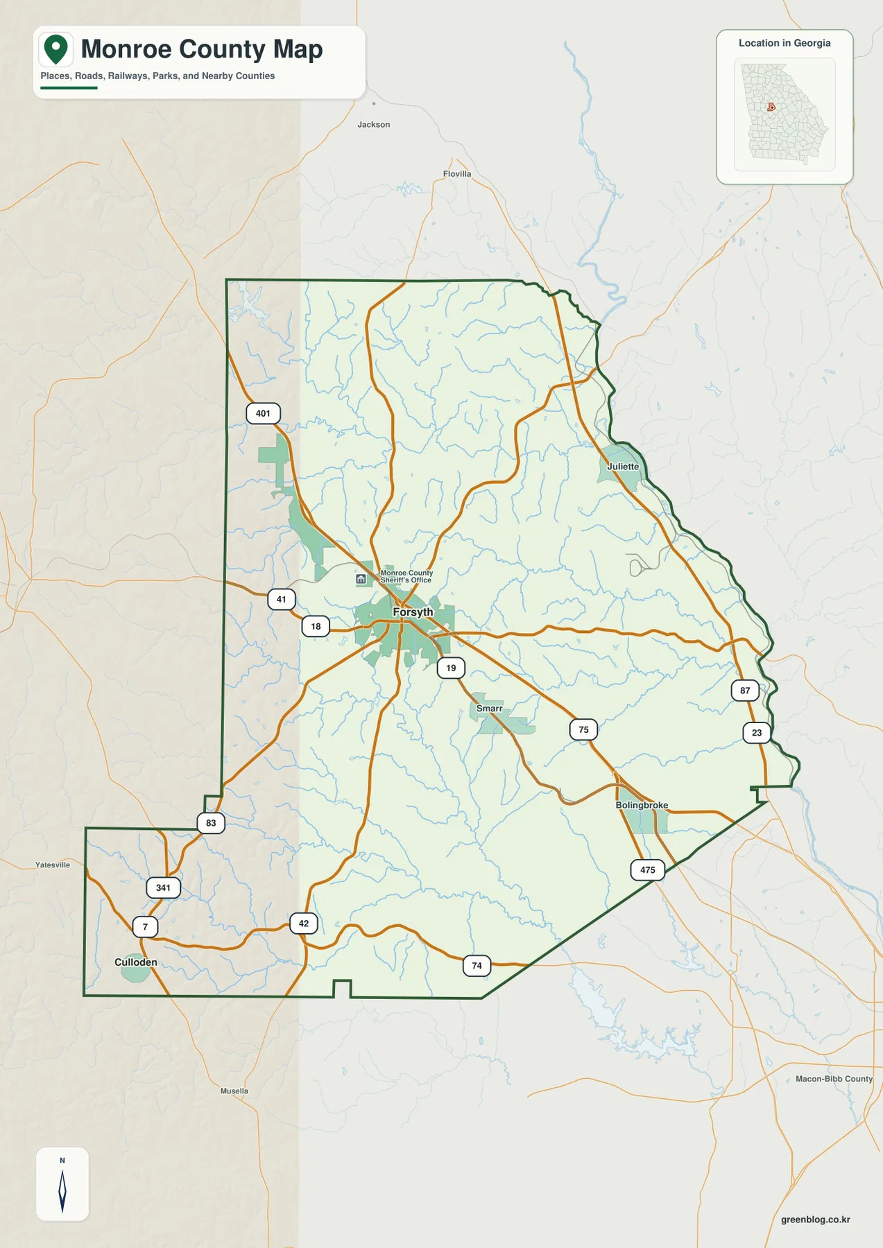
Juliette is labeled close to the northeastern edge of Monroe County, while Bolingbroke appears in the southeast. Smarr is just south of Forsyth, making it one of the closest labeled places to the county seat on this map. Culloden is different: it sits far to the southwest in the county’s projecting western section. That separation is one of the most useful things to notice because a map focused only on Forsyth can make the county feel more compact than it really is.
The surrounding county names on the city map provide a second orientation check. Butts County is north, Jasper County is northeast, Jones County is east, Upson County is southeast, Crawford County is southwest, Lamar County is west, and Bibb County is northwest. These labels help place Monroe County within central Georgia without requiring a separate statewide map. They also make the irregular eastern and southwestern boundaries easier to understand.
Two ranked cities show how far the county stretches southwest
The city map deliberately removes much of the extra labeling and ranks two major cities: Forsyth as number 1 and Culloden as number 2. Forsyth is close to the county’s central road network, whereas Culloden lies near the southwestern end of the boundary. The contrast is useful because it shows that the two principal city labels do not occupy the same central corridor. One is near the middle of the county; the other is well removed from it.
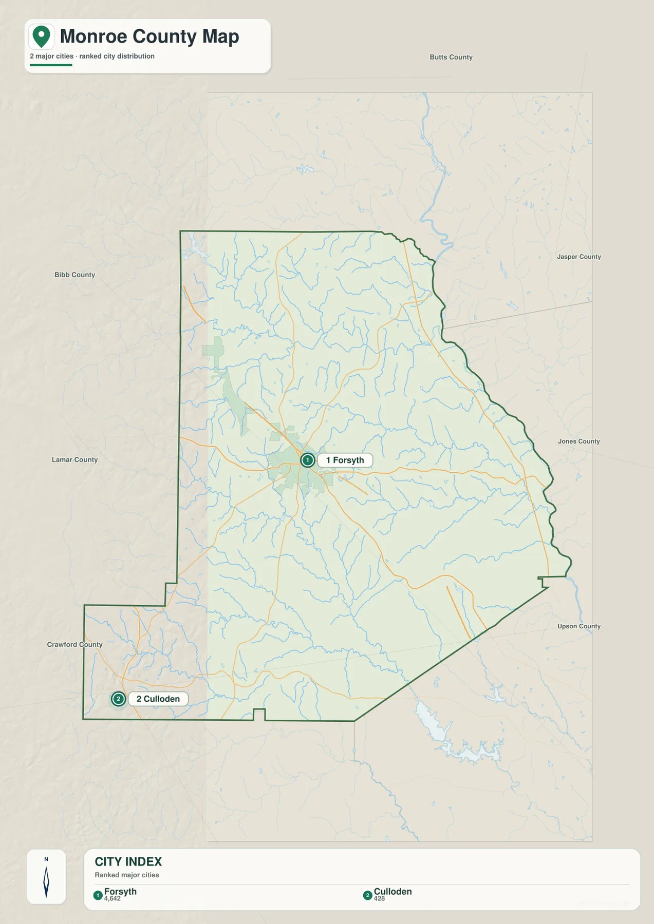
This simplified city view is best used for relative position, not as a complete settlement inventory. The general county map adds Juliette, Smarr, and Bolingbroke, so readers looking for those places should switch back to the first map. The city map also is not a driving-distance chart. It shows where the labeled cities sit inside the county rather than providing turn-by-turn routes or exact road mileage between them.
Forsyth’s role as county seat is supported by the existing county material, which also records Monroe County as having been established in 1821. On the supplied maps, however, the most important practical fact is not the date but the way Forsyth combines the administrative center with the densest group of major road connections. That makes it a natural reference point when comparing locations elsewhere in the county.
Towaliga River and a dense network of named creeks
The terrain-and-water map changes the emphasis completely. Little Towaliga River enters the northwestern part of the county, and Towaliga River runs across the northern interior from west toward the east. Rocky Creek joins the same northern system from the west, while Lee Creek is labeled near the northeastern side. Numerous smaller tributaries fill the spaces between them, so the county does not read as a landscape organized around only one river.
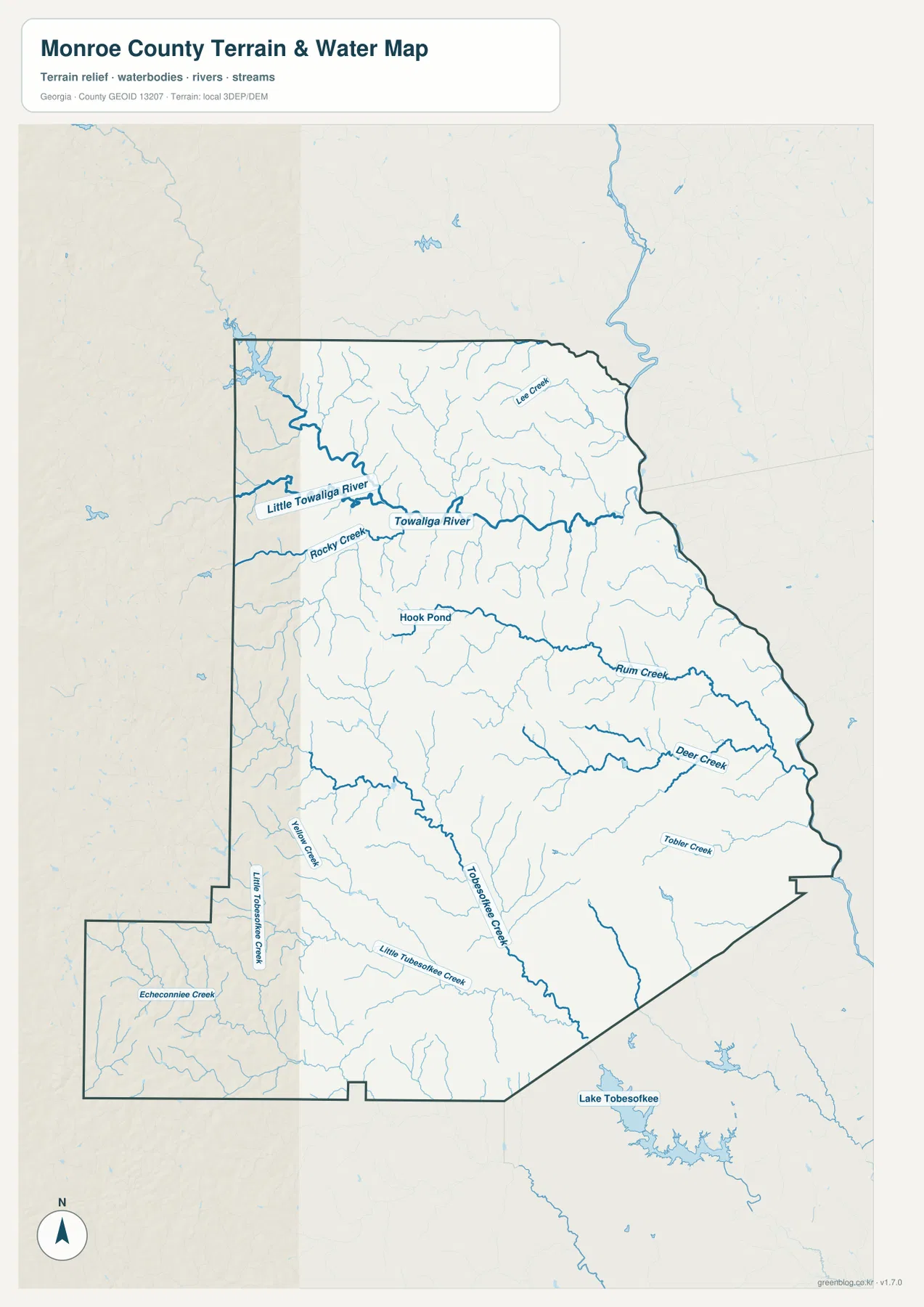
Farther south, the map labels Hook Pond near the central water network and Rum Creek extending eastward. Deer Creek and Tobler Creek appear in the eastern and southeastern half of the county. Tobesofkee Creek and Little Tobesofkee Creek cross the southern interior, while Yellow Creek and Echeconnee Creek add more drainage lines near the southwestern extension around Culloden. Lake Tobesofkee is shown beyond the county boundary to the southeast, which is useful as an outside reference point rather than a feature to treat as being inside Monroe County.
The number of named creeks explains why the blue lines on the general road map are so widespread. Many roads cross small tributaries before reaching the larger Towaliga system. This water map is therefore useful for geographic orientation, outdoor context, and classroom study, but it should not be used as a flood-zone map, property-boundary map, or navigation chart. Those tasks require more specialized and current official data.
Elevation from 112 to 238 meters reveals a higher west
The elevation map reports an actual range of about 112 to 238 meters and a mean elevation of about 166 meters. Brown and orange terrain is concentrated in much of the west and northwest, marking the relatively higher ground. Greens become more common toward the east and northeast, where lower terrain occupies broader areas. The county is not a smooth west-to-east slope, however; narrow low corridors repeatedly cut through higher ground.
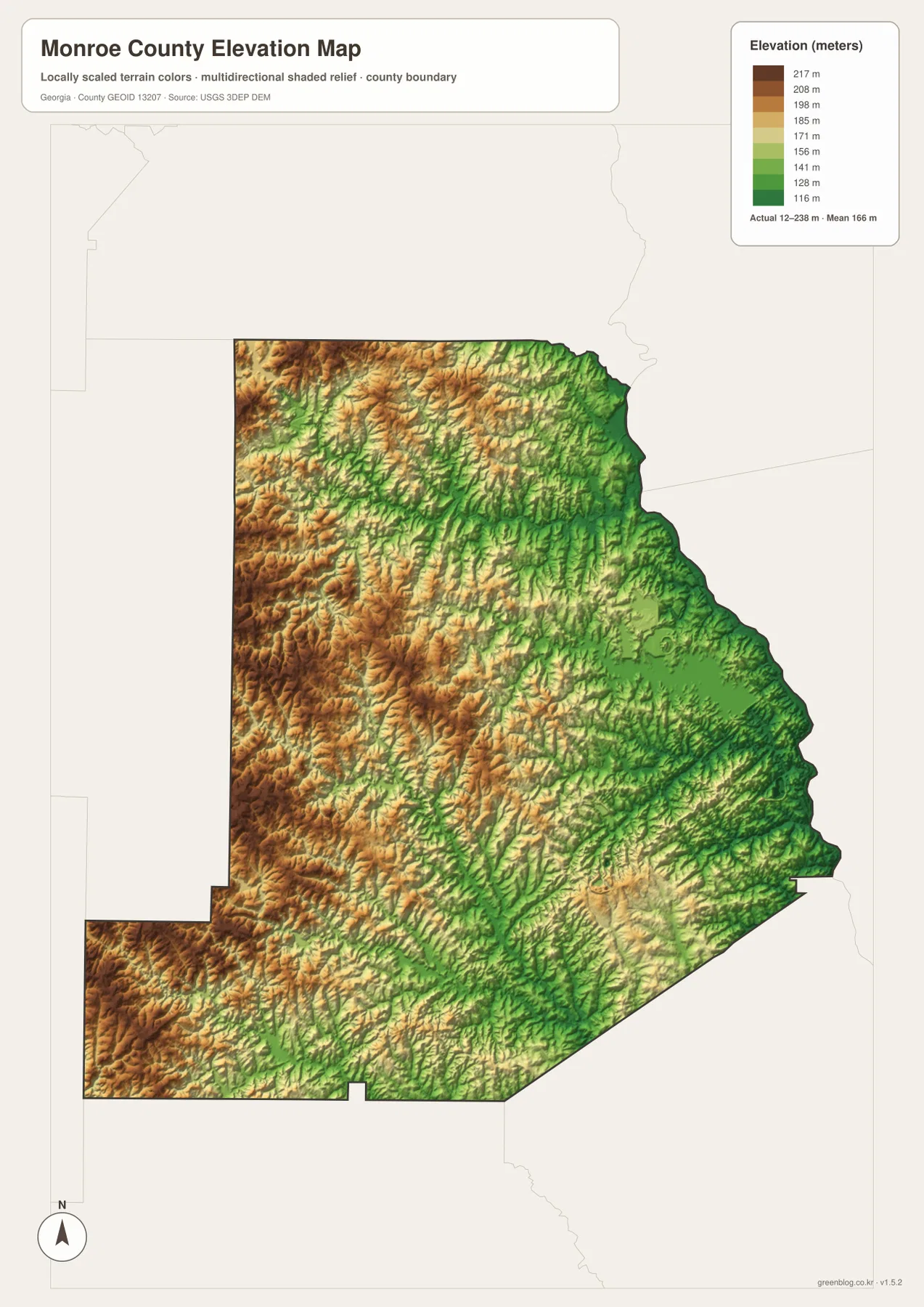
Those narrow green corridors make more sense when compared with the water map. Lower ground follows many of the same valleys occupied by Towaliga River, Rum Creek, Deer Creek, and other streams. The western half contains repeated ridges between those valleys, while the eastern half has larger areas of lower color values. Culloden’s southwestern section is also broken into ridges and creek valleys rather than appearing as one broad flat surface.
This elevation surface is designed to show county-scale differences, not survey-grade heights for a house site, road project, or engineering decision. Its strongest use is comparative: readers can see which parts of Monroe County are relatively high, where drainage valleys cut through the landscape, and how the water network relates to the shape of the terrain.
Comparing the same places across all four maps
Forsyth is a good place to start a cross-map comparison. On the general map it is surrounded by major road connections, and on the city map it is the first-ranked city near the county’s center. Switch to the water map and that same central area is crossed by a much finer network of tributaries. On the elevation map, ridges and low stream valleys alternate around it, showing that the transportation center does not sit on featureless flat land.
Culloden provides a different comparison. Its location in the southwestern projection is obvious on the city and boundary maps. The water map then shows Echeconnee Creek, Little Tobesofkee Creek, Yellow Creek, and nearby tributaries around that portion of the county. The elevation view adds tightly spaced ridges and valleys. Together, those maps show why the southwest is geographically distinct even though it remains part of the same county.
The eastern side can be read the same way. Locate Juliette and Bolingbroke on the general map, follow the Towaliga system and other creeks toward the eastern boundary on the water map, and then compare the wider green lowlands on the elevation map. Using the maps in this order keeps each one focused on what it does best instead of forcing a single map to answer every question.
- Boundary and road map: best for Forsyth, Juliette, Smarr, Bolingbroke, Culloden, route shields, and neighboring-county orientation.
- City map: best for a clean comparison of Forsyth and Culloden within the full county outline.
- Water map: best for Towaliga River, Little Towaliga River, Rocky Creek, Rum Creek, Deer Creek, and the southern creek network.
- Elevation map: best for the 112–238 meter range, higher western ridges, lower eastern terrain, and stream valleys.
Frequently Asked Questions
Where are Forsyth and Culloden on the maps?
Forsyth is near the central part of Monroe County and is the county seat. Culloden lies far to the southwest in the county’s projecting western section. The ranked city map is the clearest view for comparing those two positions, while the general map adds the roads and other labeled places around them.
Which rivers and creeks are labeled in Monroe County?
The supplied water map prominently labels Towaliga River and Little Towaliga River in the northern half, along with Rocky Creek, Lee Creek, Rum Creek, Deer Creek, Tobler Creek, Tobesofkee Creek, Little Tobesofkee Creek, Yellow Creek, and Echeconnee Creek. Smaller tributaries are also shown throughout the county.
What elevation range does the terrain map show?
The map reports an actual range of roughly 112 to 238 meters with a mean near 166 meters. Higher colors are more common in the west and northwest, while lower green terrain is broader toward the east. The map is intended for county-scale comparison and should not replace survey or engineering elevation data.
Map File Information
For larger files than the WebP page previews, download one ZIP containing four high-resolution A3 JPG maps.
- File Type: four JPG files in one ZIP archive
Related Maps
Sources and references
The following sources support county boundaries, hydrography, elevation, and general Monroe County context. For parcel work, flood-risk decisions, surveying, or other precise applications, use the current official dataset designed for that purpose.
- U.S. Census Bureau TIGER/Line Shapefiles
- USGS National Hydrography
- USGS 3D Elevation Program
- U.S. Census Bureau QuickFacts for Monroe County, Georgia
- New Georgia Encyclopedia: Monroe County
Green Map creates custom-edited map images using open geographic data sources such as geoBoundaries, Natural Earth, OpenStreetMap, and government open data. These maps are edited visual materials, not raw data files, and are provided for education, documents, presentations, and graphic reference.